
Maryland Route 312
Encyclopedia
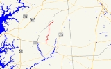
Maryland Route 312 is a state highway
in the U.S. state
of Maryland
. The state highway runs 11.41 miles (18.4 km) from MD 404
near Ridgely
north to MD 313
in Baltimore Corner
. MD 312 traverses northwestern Caroline County
, connecting Ridgely
with Bridgetown. The highway's first section was paved around Ridgely in the 1910s. The highway was completed from MD 404 to Ridgely in the mid 1920s and from north of Ridgely to Baltimore Corner in the late 1920s.
and Denton
. The roadway continues south as county-maintained Log Cabin Road. MD 312 heads north as two-lane Downes Station Road, passing through farmland until it curves to the east and meets MD 480 (Ridgely Road) on a tangent, joining that highway in a concurrency. After MD 776 (Sunset Boulevard), the old alignment of MD 312, splits to the north, MD 312 and MD 480 enter the town of Ridgely and the highway's name changes to Sixth Street. MD 312 leaves MD 480 by turning north onto Central Avenue, a two-lane street with very wide shoulders used for angle or perpendicular parking. The state highway crosses an abandoned rail line after meeting the other end of MD 776 (Railroad Avenue).
MD 312 leaves the town of Ridgely shortly after passing Ridgely Elementary School. The state highway continues north through farmland as Oakland Road, passing by Ridgely Airpark and through the hamlet of Oakland
. MD 312 intersects MD 304
(Bridgetown Road) in Bridgetown and passes through a forested area before reaching its northern terminus at MD 313 (Goldsboro Road) at Baltimore Corner.
.
{|class=wikitable
!Location
!Mile
!Destinations
!Notes
|-
|rowspan=6|Ridgely
|rowspan=2|0.00
|Log Cabin Road south
|rowspan=2|Southern terminus
|-
|
|-
|1.42
|
|South end of concurrency with MD 480
|-
|1.82
|
|
|-
|2.30
| / Central Avenue south – Greensboro
|MD 312 turns north onto Central Avenue; north end of concurrency with MD 480
|-
|2.71
| / Railroad Avenue east
|
|-
|rowspan=1|Bridgetown
|9.09
| / Bridgetown Road – Centreville
|
|-
|rowspan=1|Baltimore Corner
|11.41
|
|Northern terminus
State highway
State highway, state road or state route can refer to one of three related concepts, two of them related to a state or provincial government in a country that is divided into states or provinces :#A...
in the U.S. state
U.S. state
A U.S. state is any one of the 50 federated states of the United States of America that share sovereignty with the federal government. Because of this shared sovereignty, an American is a citizen both of the federal entity and of his or her state of domicile. Four states use the official title of...
of Maryland
Maryland
Maryland is a U.S. state located in the Mid Atlantic region of the United States, bordering Virginia, West Virginia, and the District of Columbia to its south and west; Pennsylvania to its north; and Delaware to its east...
. The state highway runs 11.41 miles (18.4 km) from MD 404
Maryland Route 404
Maryland Route 404 is a major highway on Maryland's Eastern Shore in the United States. It runs from Maryland Route 662 in Wye Mills on the border of Queen Anne's and Talbot Counties, southeast to the Delaware state line in Caroline County, where the road continues as Delaware Route 404 to Nassau...
near Ridgely
Ridgely, Maryland
Ridgely is a town in Caroline County, Maryland, United States. The population was 1,352 at the 2000 census. Its main ZIP code is 21660, but is assigned eight other "216" zip codes due to its status as a home to fulfillment companies that receive and ship mail-in offers. The primary phone exchange...
north to MD 313
Maryland Route 313
Maryland Route 313 is a state highway located on the Eastern Shore of Maryland in the United States. The route runs from U.S. Route 50 in Mardela Springs, Wicomico County north to Maryland Route 213 and Maryland Route 290 in Galena, Kent County...
in Baltimore Corner
Baltimore Corner, Maryland
Baltimore Corner is an unincorporated community on the Eastern Shore of the U.S. state of Maryland, in Caroline County, Maryland, United States. It is near the Queen Anne's County line at the intersection of Maryland Route 313 and 312. It is not to be confused with Baltimore City, located on the...
. MD 312 traverses northwestern Caroline County
Caroline County, Maryland
Caroline County is a wholly rural county located in the U.S. state of Maryland on its Eastern Shore. It is bordered by Queen Anne's County to the north, Talbot County to the west, Dorchester County to the south, Kent County, Delaware, to the east, and Sussex County, Delaware, to the southeast. As...
, connecting Ridgely
Ridgely, Maryland
Ridgely is a town in Caroline County, Maryland, United States. The population was 1,352 at the 2000 census. Its main ZIP code is 21660, but is assigned eight other "216" zip codes due to its status as a home to fulfillment companies that receive and ship mail-in offers. The primary phone exchange...
with Bridgetown. The highway's first section was paved around Ridgely in the 1910s. The highway was completed from MD 404 to Ridgely in the mid 1920s and from north of Ridgely to Baltimore Corner in the late 1920s.
Route description
MD 312 begins at an intersection with MD 404 (Shore Highway) between HillsboroHillsboro, Maryland
Hillsboro is a town in Caroline County, Maryland, United States. The population was 163 at the 2000 census. Daffin House and St. Paul's Episcopal Church were listed on the National Register of Historic Places in 1975.-Geography:...
and Denton
Denton, Maryland
Denton is a town in Caroline County, Maryland, United States. The population was 2,960 at the 2000 census. It is the county seat of Caroline County. Denton is the birthplace of former Delaware governor Sherman W. Tribbitt and author Sophie Kerr, as well as the long time home of former Maryland...
. The roadway continues south as county-maintained Log Cabin Road. MD 312 heads north as two-lane Downes Station Road, passing through farmland until it curves to the east and meets MD 480 (Ridgely Road) on a tangent, joining that highway in a concurrency. After MD 776 (Sunset Boulevard), the old alignment of MD 312, splits to the north, MD 312 and MD 480 enter the town of Ridgely and the highway's name changes to Sixth Street. MD 312 leaves MD 480 by turning north onto Central Avenue, a two-lane street with very wide shoulders used for angle or perpendicular parking. The state highway crosses an abandoned rail line after meeting the other end of MD 776 (Railroad Avenue).
MD 312 leaves the town of Ridgely shortly after passing Ridgely Elementary School. The state highway continues north through farmland as Oakland Road, passing by Ridgely Airpark and through the hamlet of Oakland
Oakland, Caroline County, Maryland
Oakland is an unincorporated community in Caroline County, Maryland, United States.-References:...
. MD 312 intersects MD 304
Maryland Route 304
Maryland Route 304 is a state highway in the U.S. state of Maryland. The state highway runs from Spider Web Road west of Centreville east to MD 312 in Bridgetown. MD 304 connects Centreville with U.S. Route 301 and several small settlements in central Queen Anne's County and northern Caroline,...
(Bridgetown Road) in Bridgetown and passes through a forested area before reaching its northern terminus at MD 313 (Goldsboro Road) at Baltimore Corner.
History
The first section of MD 312 was paved through Ridgely and north about 1 miles (1.6 km) toward Oakland by 1921. That highway was extended to Oakland by 1923. The state highway was constructed between MD 404 at Long's School House Corner and Ridgely in 1924 and 1925. The remainder of the highway through Bridgetown to MD 313 at Baltimore Corner was constructed between 1926 and 1929. MD 312 originally followed Sunset Boulevard and Railroad Avenue through Ridgely, rejoining the present route at Railroad Avenue's intersection with Central Avenue, which headed south as MD 480. In 1953, Sixth Street was completed between Sunset Boulevard and Central Avenue. MD 312 and MD 480, which was later extended west to Hillsboro, were assigned to the new road and MD 312 replaced MD 480 on Central Avenue.Junction list
The entire route is in Caroline CountyCaroline County, Maryland
Caroline County is a wholly rural county located in the U.S. state of Maryland on its Eastern Shore. It is bordered by Queen Anne's County to the north, Talbot County to the west, Dorchester County to the south, Kent County, Delaware, to the east, and Sussex County, Delaware, to the southeast. As...
.
{|class=wikitable
!Location
!Mile
!Destinations
!Notes
|-
|rowspan=6|Ridgely
Ridgely, Maryland
Ridgely is a town in Caroline County, Maryland, United States. The population was 1,352 at the 2000 census. Its main ZIP code is 21660, but is assigned eight other "216" zip codes due to its status as a home to fulfillment companies that receive and ship mail-in offers. The primary phone exchange...
|rowspan=2|0.00
|Log Cabin Road south
|rowspan=2|Southern terminus
|-
|
|-
|1.42
|
|South end of concurrency with MD 480
|-
|1.82
|
|
|-
|2.30
| / Central Avenue south – Greensboro
Greensboro, Maryland
Greensboro is a town located on the banks of the Choptank River in Caroline County, Maryland. The population was 1,632 at the 2000 census. The ZIP code is 21639. The primary phone exchange is 482 and the area code is 410...
|MD 312 turns north onto Central Avenue; north end of concurrency with MD 480
|-
|2.71
| / Railroad Avenue east
|
|-
|rowspan=1|Bridgetown
|9.09
| / Bridgetown Road – Centreville
Centreville, Maryland
Centreville is an incorporated town in Queen Anne's County, Maryland, United States. Incorporated in 1794, it is the county seat of Queen Anne's County. The population was 1,970 at the 2000 census. The ZIP code is 21617 and the area code is 410. The local telephone exchange is 758...
|
|-
|rowspan=1|Baltimore Corner
Baltimore Corner, Maryland
Baltimore Corner is an unincorporated community on the Eastern Shore of the U.S. state of Maryland, in Caroline County, Maryland, United States. It is near the Queen Anne's County line at the intersection of Maryland Route 313 and 312. It is not to be confused with Baltimore City, located on the...
|11.41
|
|Northern terminus