
Maryland Route 14
Encyclopedia
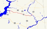
Maryland Route 14 is a state highway
in the U.S. state
of Maryland
. The state highway runs 11.51 miles (18.5 km) from MD 16
in Secretary
east to MD 313
in Eldorado
. MD 14 connects those two towns with the towns of East New Market
and Brookview
in northern Dorchester County
. The state highway also shares a concurrency
with MD 331
between the communities of Rhodesdale
and Shiloh Church. The sections of MD 14 between East New Market and Eldorado were constructed between 1911 and 1914. The highway through Secretary was constructed in the late 1920s. The portion of MD 14 east of Shiloh Church was first marked as part of U.S. Route 213 (US 213) in 1927. In the early 1930s, US 213 was rerouted through Vienna
; as a result, MD 14 was extended to its present eastern terminus in Eldorado.
over Cabin Creek, before leaving the town. The state highway's name changes to Secretary East New Market Road as the road turns southeast toward the second town. MD 14 passes through East New Market on Academy Road and Railroad Avenue, with the name change occurring at the center of town at the highway's second intersection with MD 16, known at this point as Main Street. After intersecting MD 392
(East New Market Bypass) and crossing the Seaford Line of the Maryland and Delaware Railroad
, MD 14 leaves the town limits of East New Market.
MD 14 continues east as East New Market Rhodesdale Road. The state highway passes North Dorchester High School before the western intersection with MD 331 (Shiloh Church Hurlock Road) in the hamlet of Shiloh Church. MD 14 and MD 331 head east in a concurrency to the community of Rhodesdale, where MD 331 splits to the southeast toward Vienna as Rhodesdale Vienna Road. MD 14 crosses an unused rail line owned by Delmarva Power and Light Company and continues east as Rhodesdale Eldorado Road. The state highway curves northeast and briefly passes through the town of Brookview before crossing Marshyhope Creek
. Shortly after crossing the creek, MD 14 reaches its eastern terminus at MD 313 in the town of Eldorado. MD 313 continues northeast as Eldorado Road and southeast as Sharptown Road.
at Vienna the previous year. By 1933, US 213 was relocated through Vienna and MD 14's eastern terminus was moved from Shiloh Church to Eldorado. MD 14's concurrency with US 213 became a concurrency with MD 331 in 1939 when the two latter highways swapped corridors due to the completion of the new Choptank River Bridge in 1935.
.
{| class=wikitable
!Location
!Mile
!Destinations
!Notes
|-
|rowspan=1|Secretary
|0.00
|
|Western terminus
|-
|rowspan=2|East New Market
|3.24
|
|
|-
|3.72
|
|
|-
|rowspan=1|Shiloh Church
|6.37
|
|West end of concurrency with MD 331; original eastern terminus of MD 14
|-
|rowspan=1|Rhodesdale
|8.41
|
|East end of concurrency with MD 331
|-
|rowspan=1|Eldorado
|11.51
|
|Eastern terminus
State highway
State highway, state road or state route can refer to one of three related concepts, two of them related to a state or provincial government in a country that is divided into states or provinces :#A...
in the U.S. state
U.S. state
A U.S. state is any one of the 50 federated states of the United States of America that share sovereignty with the federal government. Because of this shared sovereignty, an American is a citizen both of the federal entity and of his or her state of domicile. Four states use the official title of...
of Maryland
Maryland
Maryland is a U.S. state located in the Mid Atlantic region of the United States, bordering Virginia, West Virginia, and the District of Columbia to its south and west; Pennsylvania to its north; and Delaware to its east...
. The state highway runs 11.51 miles (18.5 km) from MD 16
Maryland Route 16
Maryland Route 16 is a state highway in the U.S. state of Maryland. The state highway runs from Taylors Island east to the Delaware state line in Hickman, where the highway continues as Delaware Route 16...
in Secretary
Secretary, Maryland
Secretary is a town in Dorchester County, Maryland, United States. The population was 503 at the 2000 census.-Geography:Secretary is located at ....
east to MD 313
Maryland Route 313
Maryland Route 313 is a state highway located on the Eastern Shore of Maryland in the United States. The route runs from U.S. Route 50 in Mardela Springs, Wicomico County north to Maryland Route 213 and Maryland Route 290 in Galena, Kent County...
in Eldorado
Eldorado, Maryland
Eldorado is a town in Dorchester County, Maryland, United States. The population was 60 at the 2000 census.-History:Rehoboth was listed on the National Register of Historic Places in 1972...
. MD 14 connects those two towns with the towns of East New Market
East New Market, Maryland
East New Market is a town located in Dorchester County, Maryland. As of the 2000 census, the town had a total population of 167. The zip code is 21631.-Geography:East New Market is located at ....
and Brookview
Brookview, Maryland
Brookview is a town in Dorchester County, Maryland, United States. The population was 65 at the 2000 census.-Geography:Brookview is located at ....
in northern Dorchester County
Dorchester County, Maryland
Dorchester County is a county located in the U.S. state of Maryland on its Eastern Shore. It is bordered by the Choptank River to the north, Talbot County to the northwest, Caroline County to the northeast, Wicomico County to the southeast, Sussex County, Delaware, to the east, and the Chesapeake...
. The state highway also shares a concurrency
Concurrency (road)
A concurrency, overlap, or coincidence in a road network is an instance of one physical road bearing two or more different highway, motorway, or other route numbers...
with MD 331
Maryland Route 331
Maryland Route 331 is a state highway on the Eastern Shore of Maryland in the United States. The route runs from Vienna in Dorchester County northwest to Easton in Talbot County, intersecting U.S. Route 50 at both ends. MD 331 is a two-lane undivided road most of its length that passes mostly...
between the communities of Rhodesdale
Rhodesdale, Maryland
Rhodesdale is an unincorporated community in Dorchester County, Maryland, United States.-References:...
and Shiloh Church. The sections of MD 14 between East New Market and Eldorado were constructed between 1911 and 1914. The highway through Secretary was constructed in the late 1920s. The portion of MD 14 east of Shiloh Church was first marked as part of U.S. Route 213 (US 213) in 1927. In the early 1930s, US 213 was rerouted through Vienna
Vienna, Maryland
Vienna is a town in Dorchester County, Maryland, United States. The population was 280 at the 2000 census.-History:Vienna was founded in 1706. It thrived on trade, shipbuilding and tobacco farming. Throughout the next century, the British would raid the town repeatedly, and also during the War of...
; as a result, MD 14 was extended to its present eastern terminus in Eldorado.
Route description
MD 14 begins at an intersection with MD 16 (Mt. Holly Road) a short distance west of East New Market. The state highway heads north as Secretary Road in a straight line before curving to the east and crossing the Warwick River, where the highway's name changes to Main Street and the route enters the town of Secretary. MD 14 intersects Poplar Street, which leads to the Suicide BridgeSuicide Bridge
Suicide Bridge is a novel by Iain Sinclair.The book examines the characters of William Blake's Jerusalem as influenced by their psychogeography.The book mixes poetry with prose essays.-External links:*, militant esthetix, Ben Watson...
over Cabin Creek, before leaving the town. The state highway's name changes to Secretary East New Market Road as the road turns southeast toward the second town. MD 14 passes through East New Market on Academy Road and Railroad Avenue, with the name change occurring at the center of town at the highway's second intersection with MD 16, known at this point as Main Street. After intersecting MD 392
Maryland Route 392
Maryland Route 392 is a state highway in the U.S. state of Maryland. The state highway runs from MD 16 in East New Market east to the Delaware state line in Reliance, where the highway continues east as Delaware Route 20 . MD 392 connects East New Market with Hurlock as well as Seaford,...
(East New Market Bypass) and crossing the Seaford Line of the Maryland and Delaware Railroad
Maryland and Delaware Railroad
The Maryland and Delaware Railroad Company is a Class III short-line railroad, formed in 1977 to operate several branch lines of the former Penn Central Railroad in both Maryland and Delaware. These branches were omitted from the system plan for Conrail in 1976 and would have been discontinued...
, MD 14 leaves the town limits of East New Market.
MD 14 continues east as East New Market Rhodesdale Road. The state highway passes North Dorchester High School before the western intersection with MD 331 (Shiloh Church Hurlock Road) in the hamlet of Shiloh Church. MD 14 and MD 331 head east in a concurrency to the community of Rhodesdale, where MD 331 splits to the southeast toward Vienna as Rhodesdale Vienna Road. MD 14 crosses an unused rail line owned by Delmarva Power and Light Company and continues east as Rhodesdale Eldorado Road. The state highway curves northeast and briefly passes through the town of Brookview before crossing Marshyhope Creek
Marshyhope Creek
Marshyhope Creek is a tributary of the Nanticoke River on the Delmarva Peninsula. It rises in Kent County, Delaware, and runs through Caroline County, Maryland, and Dorchester County, Maryland....
. Shortly after crossing the creek, MD 14 reaches its eastern terminus at MD 313 in the town of Eldorado. MD 313 continues northeast as Eldorado Road and southeast as Sharptown Road.
History
The first section of MD 14 to be constructed as a modern highway was between East New Market and Shiloh Church in 1911. The next two sections were constructed as part of the major north–south highway of the Eastern Shore; the Shiloh Church–Brookview segment was built in 1912 and the Brookview-Eldorado portion was completed in 1914. When route numbers were first assigned in 1927, MD 14 was placed on the western section and US 213 was marked on the two eastern sections. MD 14 between Secretary and East New Market was constructed in 1926 and 1927. The final section between the western junction with MD 16 and Secretary was paved in 1929 and 1930. While the modern bridge over Marshyhope Creek at Brookview was completed in 1932, it served a lighter traffic load than the previous bridge because of the opening of a new bridge over the Nanticoke RiverNanticoke River
The Nanticoke River is a major tributary of the Chesapeake Bay on the Delmarva Peninsula. It rises in southern Kent County, Delaware, flows through Sussex County, Delaware, and forms the boundary between Dorchester County, Maryland and Wicomico County, Maryland. The river course proceeds southwest...
at Vienna the previous year. By 1933, US 213 was relocated through Vienna and MD 14's eastern terminus was moved from Shiloh Church to Eldorado. MD 14's concurrency with US 213 became a concurrency with MD 331 in 1939 when the two latter highways swapped corridors due to the completion of the new Choptank River Bridge in 1935.
Junction list
The entire route is in Dorchester CountyDorchester County, Maryland
Dorchester County is a county located in the U.S. state of Maryland on its Eastern Shore. It is bordered by the Choptank River to the north, Talbot County to the northwest, Caroline County to the northeast, Wicomico County to the southeast, Sussex County, Delaware, to the east, and the Chesapeake...
.
{| class=wikitable
!Location
!Mile
!Destinations
!Notes
|-
|rowspan=1|Secretary
Secretary, Maryland
Secretary is a town in Dorchester County, Maryland, United States. The population was 503 at the 2000 census.-Geography:Secretary is located at ....
|0.00
|
|Western terminus
|-
|rowspan=2|East New Market
East New Market, Maryland
East New Market is a town located in Dorchester County, Maryland. As of the 2000 census, the town had a total population of 167. The zip code is 21631.-Geography:East New Market is located at ....
|3.24
|
|
|-
|3.72
|
|
|-
|rowspan=1|Shiloh Church
|6.37
|
|West end of concurrency with MD 331; original eastern terminus of MD 14
|-
|rowspan=1|Rhodesdale
Rhodesdale, Maryland
Rhodesdale is an unincorporated community in Dorchester County, Maryland, United States.-References:...
|8.41
|
|East end of concurrency with MD 331
|-
|rowspan=1|Eldorado
Eldorado, Maryland
Eldorado is a town in Dorchester County, Maryland, United States. The population was 60 at the 2000 census.-History:Rehoboth was listed on the National Register of Historic Places in 1972...
|11.51
|
|Eastern terminus