
Maryland Route 480
Encyclopedia
Maryland Route 480 is a state highway
in the U.S. state
of Maryland
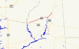
. Known for most of its length as Ridgely Road, the state highway runs 9.08 miles (14.6 km) from MD 404
in Hillsboro
east to MD 313
in Greensboro
. MD 480 passes through Ridgely
, where it has a concurrency with MD 312
. The state highway was constructed between Ridgely and Greensboro in the early 1930s. MD 480 was rerouted in both towns in the early 1950s before being extended west to Hillsboro in the late 1950s.
at a distance until the highway enters Greensboro, where its name changes again to Main Street. MD 480 intersects MD 314
(Sunset Avenue) in the center of the town. The state highway traverses an S-curve and passes Greensboro Elementary School before reaching its northern terminus at MD 313 (Greensboro Road).
.
{|class=wikitable
!Location
!Mile
!Destinations
!Notes
|-
|rowspan=2|Hillsboro
|rowspan=2|0.00
|Ridgely Road south
|rowspan=2|Western terminus
|-
|
|-
|rowspan=3|Ridgely
|2.50
|
|West end of concurrency with MD 312
|-
|2.90
|
|
|-
|3.38
| / Central Avenue south
|East end of concurrency with MD 312
|-
|rowspan=2|Greensboro
|8.21
|
|
|-
|9.08
|
|Eastern terminus
State highway
State highway, state road or state route can refer to one of three related concepts, two of them related to a state or provincial government in a country that is divided into states or provinces :#A...
in the U.S. state
U.S. state
A U.S. state is any one of the 50 federated states of the United States of America that share sovereignty with the federal government. Because of this shared sovereignty, an American is a citizen both of the federal entity and of his or her state of domicile. Four states use the official title of...
of Maryland
Maryland
Maryland is a U.S. state located in the Mid Atlantic region of the United States, bordering Virginia, West Virginia, and the District of Columbia to its south and west; Pennsylvania to its north; and Delaware to its east...
. Known for most of its length as Ridgely Road, the state highway runs 9.08 miles (14.6 km) from MD 404
Maryland Route 404
Maryland Route 404 is a major highway on Maryland's Eastern Shore in the United States. It runs from Maryland Route 662 in Wye Mills on the border of Queen Anne's and Talbot Counties, southeast to the Delaware state line in Caroline County, where the road continues as Delaware Route 404 to Nassau...
in Hillsboro
Hillsboro, Maryland
Hillsboro is a town in Caroline County, Maryland, United States. The population was 163 at the 2000 census. Daffin House and St. Paul's Episcopal Church were listed on the National Register of Historic Places in 1975.-Geography:...
east to MD 313
Maryland Route 313
Maryland Route 313 is a state highway located on the Eastern Shore of Maryland in the United States. The route runs from U.S. Route 50 in Mardela Springs, Wicomico County north to Maryland Route 213 and Maryland Route 290 in Galena, Kent County...
in Greensboro
Greensboro, Maryland
Greensboro is a town located on the banks of the Choptank River in Caroline County, Maryland. The population was 1,632 at the 2000 census. The ZIP code is 21639. The primary phone exchange is 482 and the area code is 410...
. MD 480 passes through Ridgely
Ridgely, Maryland
Ridgely is a town in Caroline County, Maryland, United States. The population was 1,352 at the 2000 census. Its main ZIP code is 21660, but is assigned eight other "216" zip codes due to its status as a home to fulfillment companies that receive and ship mail-in offers. The primary phone exchange...
, where it has a concurrency with MD 312
Maryland Route 312
Maryland Route 312 is a state highway in the U.S. state of Maryland. The state highway runs from MD 404 near Ridgely north to MD 313 in Baltimore Corner. MD 312 traverses northwestern Caroline County, connecting Ridgely with Bridgetown. The highway's first section was paved around Ridgely in...
. The state highway was constructed between Ridgely and Greensboro in the early 1930s. MD 480 was rerouted in both towns in the early 1950s before being extended west to Hillsboro in the late 1950s.
Route description
MD 480 begins at an intersection with MD 404 in Hillsboro. Ridgely Road continues south toward the center of Hillsboro. MD 480 heads northeast through farmland until it meets MD 312 (Downes Station Road) on the outskirts of Ridgely. The two state highways continue northeast, with MD 776 (Sunset Boulevard) splitting to the north immediately before the road enters the town limits of Ridgely, where its name temporarily changes to Sixth Street and the highway passes Martin Sutton Memorial Park. The concurrency of MD 480 and MD 312 ends where the latter highway heads north into the center of town on Central Avenue. MD 480 heads east out of town, continuing straight through farmland. After traversing Forge Branch, the state highway veers to the northeast, paralleling the Choptank RiverChoptank River
The Choptank River is a major tributary of the Chesapeake Bay on the Delmarva Peninsula. Running for , it rises in Kent County, Delaware, runs through Caroline County, Maryland and forms much of the border between Talbot County, Maryland on the north, and Caroline County and Dorchester County on...
at a distance until the highway enters Greensboro, where its name changes again to Main Street. MD 480 intersects MD 314
Maryland Route 314
Maryland Route 314 is a state highway in the U.S. state of Maryland. The state highway runs from the beginning of state maintenance in Greensboro east to the Delaware state line at Whiteleysburg, where the highway continues east as Delaware Route 12 . What is now MD 314 was paved in Greensboro...
(Sunset Avenue) in the center of the town. The state highway traverses an S-curve and passes Greensboro Elementary School before reaching its northern terminus at MD 313 (Greensboro Road).
History
MD 480 was under construction from Ridgely to Greensboro by 1932 and completed in 1933. The state highway originally followed Central Avenue in Ridgely south from MD 312, then turned east onto Sixth Street toward Greensboro. In Greensboro, MD 480 had its eastern terminus at present-day MD 314. MD 480 north to its present eastern terminus and MD 314 east across the Choptank River were originally part of MD 313. When MD 313 bypassed Greensboro in 1950, MD 480 was extended north through Greensboro to its present terminus. When the Ridgely Cutoff was completed in 1953, MD 312 replaced MD 480 on Central Avenue. MD 480's western terminus was the intersection of Central Avenue and Sixth Street until MD 480 was extended west to MD 404 in Hillsboro in 1959.Junction list
The entire route is in Caroline CountyCaroline County, Maryland
Caroline County is a wholly rural county located in the U.S. state of Maryland on its Eastern Shore. It is bordered by Queen Anne's County to the north, Talbot County to the west, Dorchester County to the south, Kent County, Delaware, to the east, and Sussex County, Delaware, to the southeast. As...
.
{|class=wikitable
!Location
!Mile
!Destinations
!Notes
|-
|rowspan=2|Hillsboro
Hillsboro, Maryland
Hillsboro is a town in Caroline County, Maryland, United States. The population was 163 at the 2000 census. Daffin House and St. Paul's Episcopal Church were listed on the National Register of Historic Places in 1975.-Geography:...
|rowspan=2|0.00
|Ridgely Road south
|rowspan=2|Western terminus
|-
|
|-
|rowspan=3|Ridgely
Ridgely, Maryland
Ridgely is a town in Caroline County, Maryland, United States. The population was 1,352 at the 2000 census. Its main ZIP code is 21660, but is assigned eight other "216" zip codes due to its status as a home to fulfillment companies that receive and ship mail-in offers. The primary phone exchange...
|2.50
|
|West end of concurrency with MD 312
|-
|2.90
|
|
|-
|3.38
| / Central Avenue south
|East end of concurrency with MD 312
|-
|rowspan=2|Greensboro
Greensboro, Maryland
Greensboro is a town located on the banks of the Choptank River in Caroline County, Maryland. The population was 1,632 at the 2000 census. The ZIP code is 21639. The primary phone exchange is 482 and the area code is 410...
|8.21
|
|
|-
|9.08
|
|Eastern terminus