
Maryland Route 290
Encyclopedia
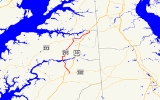
Maryland Route 290 is a state highway
in the U.S. state
of Maryland
. The state highway runs 17.2 miles (27.7 km) from MD 300
at Dudley Corners north to MD 299
in Sassafras
. MD 290 roughly parallels U.S. Route 301
(US 301), which it intersects twice, as it connects the communities of Crumpton
in northern Queen Anne's County
and Chesterville
and Galena
in eastern Kent County
. MD 290 in Queen Anne's County was constructed as MD 301 in the early to mid 1920s. In Kent County, a portion south of Galena was built in the late 1910s; MD 290 was extended south to Crumpton in the late 1920s. MD 290 assumed the course of MD 301 in 1940 to avoid a number conflict with US 301. MD 290 was extended east from Galena to Sassafras in the late 1940s.
(McGinnes Road). The state highway passes through the town of Crumpton before crossing the Chester River into Kent County.
MD 290 heads north as Crumpton Road until the state highway turns east for a short concurrency
with MD 291
(River Road). MD 290 turns north and intersects MD 444
(Locust Grove Road) and Chesterville Bridge Road within Chesterville, where the name of the highway changes to Chesterville Road. The state highway crosses the Chestertown Branch of the Northern Line of the Maryland and Delaware Railroad
at the hamlet of Lambson. MD 290 intersects Irelands Corner Road, the old alignment of MD 313
, before joining MD 313 (Massey Galena Road) in a concurrency into the town of Galena, where the highway becomes Main Street. North–south Main Street intersects east–west Cross Street in the center of town next to the town hall. MD 213
heads west toward Chestertown and north toward Cecilton, MD 313 has its northern terminus, and MD 290 turns east toward Sassafras. MD 290 becomes Galena Sassafras Road and crosses Mill Creek, Swantown Creek, and Jacobs Creek before meeting US 301 for the second time at a diamond interchange
. A short distance east of US 301, MD 290 reaches its northern terminus at MD 299 near the village of Sassafras. MD 299 heads south as Massey Road and northeast as a continuation of Galena Sassafras Road.
The first section of MD 290 in Kent County was paved as a state-aid road between Galena and the railroad crossing at Lambson between 1915 and 1919. The highway was extended south from Lambson to the Chester River in 1929 and 1930. MD 290 was extended south over MD 301's course to Dudley Corners in 1940 to remove a number conflict with US 301, which was extended north from Virginia to Baltimore the same year.
The portion of MD 290 between Galena and Sassafras was constructed between 1946 and 1948. MD 290 was extended north through Galena and east along the new road to its present northern terminus at MD 299 in 1949. A modern bridge was constructed at Crumpton in 1951. When the Blue Star Memorial Highway was completed in Queen Anne's and Kent counties in 1956, interchanges were constructed at both junctions with MD 290. MD 290 was widened between Dudley Corners and Crumpton and between Galena and Sassafras in 1956. At the same time, MD 290 was realigned south of Galena in conjunction with the relocation of MD 313 to bypass Irelands Corner.
!County
!Location
!Mile
!Destinations
!Notes
|-
|rowspan=4|Queen Anne's
|rowspan=3|Dudley Corners
|rowspan=2|0.00
|Benton Corners Road south
|rowspan=2|Southern terminus
|-
|
|-
|1.21
|, Wilmington
|Interchange
|-
|Crumpton
|3.69
|
|
|-
|colspan=2|
|4.80
|colspan=2 align=center|Bridge over Chester River
|-
|rowspan=7|Kent
|rowspan=3|Chesterville
|5.91
|
|South end of concurrency with MD 291
|-
|6.58
|
|North end of concurrency with MD 291
|-
|7.56
| / Chesterville Bridge Road east
|
|-
|rowspan=2|Galena
|12.04
|
|South end of concurrency with MD 313
|-
|12.76
|
|North end of concurrency with MD 313; MD 290 turns east at this intersection
|-
|rowspan=2|Sassafras
|16.84
|, Wilmington
|Diamond interchange
|-
|17.20
|
|Northern terminus
State highway
State highway, state road or state route can refer to one of three related concepts, two of them related to a state or provincial government in a country that is divided into states or provinces :#A...
in the U.S. state
U.S. state
A U.S. state is any one of the 50 federated states of the United States of America that share sovereignty with the federal government. Because of this shared sovereignty, an American is a citizen both of the federal entity and of his or her state of domicile. Four states use the official title of...
of Maryland
Maryland
Maryland is a U.S. state located in the Mid Atlantic region of the United States, bordering Virginia, West Virginia, and the District of Columbia to its south and west; Pennsylvania to its north; and Delaware to its east...
. The state highway runs 17.2 miles (27.7 km) from MD 300
Maryland Route 300
Maryland Route 300 is a state highway in the U.S. state of Maryland. Known for most of its length as Sudlersville Road, the state highway runs from MD 213 in Church Hill east to the Delaware state line, where the highway continues as Delaware Route 300...
at Dudley Corners north to MD 299
Maryland Route 299
Maryland Route 299 is a state highway in the U.S. state of Maryland. The state highway runs from MD 313 and MD 330 in Massey in eastern Kent County north to U.S. Route 301 near Warwick in far southern Cecil County. MD 299 was constructed from Massey to the Sassafras River around 1930 and from...
in Sassafras
Sassafras, Maryland
Sassafras is an unincorporated community in Kent County, Maryland, United States.-References:...
. MD 290 roughly parallels U.S. Route 301
U.S. Route 301 in Maryland
U.S. Route 301 in Maryland is a major highway that runs from Delaware to the Governor Harry W. Nice Memorial Bridge into Virginia. It passes through three of Maryland's four main regions: the Eastern Shore, the Baltimore-Washington Metropolitan Area, and Southern Maryland...
(US 301), which it intersects twice, as it connects the communities of Crumpton
Crumpton, Maryland
Crumpton is an unincorporated community in Queen Anne's County, Maryland, United States. Crumpton is located along the Chester River west-southwest of Millington. Crumpton has a post office with ZIP code 21628....
in northern Queen Anne's County
Queen Anne's County, Maryland
Queen Anne's County is a county located on the Eastern Shore of the U.S. state of Maryland.As of 2010, the population was 47,798. Its county seat and most populous municipality is Centreville. The census-designated place of Stevensville is the county's most populous place...
and Chesterville
Chesterville, Maryland
Chesterville is an unincorporated community in Kent County, Maryland, United States.-References:...
and Galena
Galena, Maryland
Galena is a town in Kent County, Maryland, United States. The population was 428 at the 2000 census.-Geography:Galena is located at .According to the United States Census Bureau, the town has a total area of , all of it land....
in eastern Kent County
Kent County, Maryland
Kent County is a county located in the U.S. state of Maryland, on its Eastern Shore. It was named for the county of Kent in England. Its county seat is Chestertown. In 2010, the county population was 20,197...
. MD 290 in Queen Anne's County was constructed as MD 301 in the early to mid 1920s. In Kent County, a portion south of Galena was built in the late 1910s; MD 290 was extended south to Crumpton in the late 1920s. MD 290 assumed the course of MD 301 in 1940 to avoid a number conflict with US 301. MD 290 was extended east from Galena to Sassafras in the late 1940s.
Route description
MD 290 begins at an intersection with MD 300 (Sudlersville Road) in the hamlet of Dudley Corners. Benton Corners Road heads south from the intersection as a county highway. MD 290 heads north as Dudley Corner Road, a two-lane road that heads north through farmland. After crossing Red Lion Branch, the state highway passes through an interchange with US 301 (Blue Star Memorial Highway). MD 290 passes through the hamlet of Pondtown before reaching an intersection with MD 544Maryland Route 544
Maryland Route 544 is a state highway in the U.S. state of Maryland. Known as McGinnes Road, the state highway runs from MD 213 in Kingstown east to MD 313 in Unicorn. MD 544, which spans the northern tier of Queen Anne's County, is officially separated into two sections, MD 544 and MD 544A,...
(McGinnes Road). The state highway passes through the town of Crumpton before crossing the Chester River into Kent County.
MD 290 heads north as Crumpton Road until the state highway turns east for a short concurrency
Concurrency (road)
A concurrency, overlap, or coincidence in a road network is an instance of one physical road bearing two or more different highway, motorway, or other route numbers...
with MD 291
Maryland Route 291
Maryland Route 291 is a state highway in the U.S. state of Maryland. The state highway runs from MD 20 in Chestertown east to the Delaware state line east of Millington, where the highway continues east as Delaware Route 6...
(River Road). MD 290 turns north and intersects MD 444
Maryland Route 444
Maryland Route 444 is a state highway in the U.S. state of Maryland. The state highway runs from MD 290 in Chesterville north to the end of state maintenance in Kentmore Park. MD 444 connects Chesterville and Kentmore Park with Locust Grove on MD 213. The state highway was constructed in the...
(Locust Grove Road) and Chesterville Bridge Road within Chesterville, where the name of the highway changes to Chesterville Road. The state highway crosses the Chestertown Branch of the Northern Line of the Maryland and Delaware Railroad
Maryland and Delaware Railroad
The Maryland and Delaware Railroad Company is a Class III short-line railroad, formed in 1977 to operate several branch lines of the former Penn Central Railroad in both Maryland and Delaware. These branches were omitted from the system plan for Conrail in 1976 and would have been discontinued...
at the hamlet of Lambson. MD 290 intersects Irelands Corner Road, the old alignment of MD 313
Maryland Route 313
Maryland Route 313 is a state highway located on the Eastern Shore of Maryland in the United States. The route runs from U.S. Route 50 in Mardela Springs, Wicomico County north to Maryland Route 213 and Maryland Route 290 in Galena, Kent County...
, before joining MD 313 (Massey Galena Road) in a concurrency into the town of Galena, where the highway becomes Main Street. North–south Main Street intersects east–west Cross Street in the center of town next to the town hall. MD 213
Maryland Route 213
Maryland Route 213 is a state highway located on the Eastern Shore of Maryland in the United States. The route runs from Maryland Route 662 in Wye Mills, Queen Anne's County north to the Pennsylvania border in Cecil County, where it continues into that state as Pennsylvania Route 841...
heads west toward Chestertown and north toward Cecilton, MD 313 has its northern terminus, and MD 290 turns east toward Sassafras. MD 290 becomes Galena Sassafras Road and crosses Mill Creek, Swantown Creek, and Jacobs Creek before meeting US 301 for the second time at a diamond interchange
Diamond interchange
A diamond interchange is a common type of road junction, used where a freeway crosses a minor road. The freeway itself is grade-separated from the minor road, one crossing the other over a bridge...
. A short distance east of US 301, MD 290 reaches its northern terminus at MD 299 near the village of Sassafras. MD 299 heads south as Massey Road and northeast as a continuation of Galena Sassafras Road.
History
The highway between Dudley Corners and Crumpton was marked as one of the original state roads destined for improvement by the Maryland State Roads Commission in 1909. However, work on the highway was postponed indefinitely since it was not considered an essential part of the state road system. The short segment between MD 544 and Crumpton was paved as a state-aid road by 1921. The Crumpton–Dudley Corners highway was finally constructed in 1924 and 1925. This highway was designated MD 301.The first section of MD 290 in Kent County was paved as a state-aid road between Galena and the railroad crossing at Lambson between 1915 and 1919. The highway was extended south from Lambson to the Chester River in 1929 and 1930. MD 290 was extended south over MD 301's course to Dudley Corners in 1940 to remove a number conflict with US 301, which was extended north from Virginia to Baltimore the same year.
The portion of MD 290 between Galena and Sassafras was constructed between 1946 and 1948. MD 290 was extended north through Galena and east along the new road to its present northern terminus at MD 299 in 1949. A modern bridge was constructed at Crumpton in 1951. When the Blue Star Memorial Highway was completed in Queen Anne's and Kent counties in 1956, interchanges were constructed at both junctions with MD 290. MD 290 was widened between Dudley Corners and Crumpton and between Galena and Sassafras in 1956. At the same time, MD 290 was realigned south of Galena in conjunction with the relocation of MD 313 to bypass Irelands Corner.
Junction list
{| class=wikitable!County
!Location
!Mile
!Destinations
!Notes
|-
|rowspan=4|Queen Anne's
Queen Anne's County, Maryland
Queen Anne's County is a county located on the Eastern Shore of the U.S. state of Maryland.As of 2010, the population was 47,798. Its county seat and most populous municipality is Centreville. The census-designated place of Stevensville is the county's most populous place...
|rowspan=3|Dudley Corners
|rowspan=2|0.00
|Benton Corners Road south
|rowspan=2|Southern terminus
|-
|
|-
|1.21
|, Wilmington
Wilmington, Delaware
Wilmington is the largest city in the state of Delaware, United States, and is located at the confluence of the Christina River and Brandywine Creek, near where the Christina flows into the Delaware River. It is the county seat of New Castle County and one of the major cities in the Delaware Valley...
|Interchange
|-
|Crumpton
Crumpton, Maryland
Crumpton is an unincorporated community in Queen Anne's County, Maryland, United States. Crumpton is located along the Chester River west-southwest of Millington. Crumpton has a post office with ZIP code 21628....
|3.69
|
|
|-
|colspan=2|
|4.80
|colspan=2 align=center|Bridge over Chester River
Chester River
The Chester River is a major tributary of the Chesapeake Bay on the Delmarva Peninsula. It is about long, and its watershed encompasses , which includes of land. Thus the total watershed area is 20% water. It forms the border between Kent County and Queen Anne's County, Maryland, with its...
|-
|rowspan=7|Kent
Kent County, Maryland
Kent County is a county located in the U.S. state of Maryland, on its Eastern Shore. It was named for the county of Kent in England. Its county seat is Chestertown. In 2010, the county population was 20,197...
|rowspan=3|Chesterville
Chesterville, Maryland
Chesterville is an unincorporated community in Kent County, Maryland, United States.-References:...
|5.91
|
|South end of concurrency with MD 291
|-
|6.58
|
|North end of concurrency with MD 291
|-
|7.56
| / Chesterville Bridge Road east
|
|-
|rowspan=2|Galena
Galena, Maryland
Galena is a town in Kent County, Maryland, United States. The population was 428 at the 2000 census.-Geography:Galena is located at .According to the United States Census Bureau, the town has a total area of , all of it land....
|12.04
|
|South end of concurrency with MD 313
|-
|12.76
|
|North end of concurrency with MD 313; MD 290 turns east at this intersection
|-
|rowspan=2|Sassafras
Sassafras, Maryland
Sassafras is an unincorporated community in Kent County, Maryland, United States.-References:...
|16.84
|, Wilmington
Wilmington, Delaware
Wilmington is the largest city in the state of Delaware, United States, and is located at the confluence of the Christina River and Brandywine Creek, near where the Christina flows into the Delaware River. It is the county seat of New Castle County and one of the major cities in the Delaware Valley...
|Diamond interchange
|-
|17.20
|
|Northern terminus