
Maryland Route 302
Encyclopedia
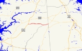
Maryland Route 302 is a state highway
in the U.S. state
of Maryland
. Known for most of its length as Barclay Road, the state highway runs 10.21 miles (16.4 km) from U.S. Route 301
(US 301) west of Barclay
east to the Delaware
state line east of Templeville
, where the highway continues east as Delaware Route 11
(DE 11). MD 302 follows the Queen Anne's
–Caroline
county line for part of its length near Templeville. The county line road is considered to be in Caroline County for maintenance purposes. MD 302 was first paved in Barclay in the early 1920s and from Templeville to the state line in the late 1920s. The gap between Barclay and Templeville was filled in the late 1930s. MD 302 was extended west toward Church Hill
in the late 1940s and to US 301 in the mid 1960s.
and intersects MD 313
(Goldsboro Road). The state highway becomes Barclay Road again upon leaving the town limits and passes through a mix of farmland and forest. The state highway runs atop the Queen Anne's–Caroline county line starting just before the intersection with Woodyard Road. MD 302 passes through the town of Templeville, where the highway intersects MD 454
(Crown Stone Road). East of the town, shortly after crossing Beaver Dam Ditch, MD 302 reaches its eastern terminus at the Delaware state line. The highway continues east as DE 11 (Arthursville Road) toward Hartly.
{|class=wikitable
!County
!Location
!Mile
!Intersection
!Notes
|-
|rowspan=3|Queen Anne's
|rowspan=2|
|rowspan=2|0.00
|Hall Road west – Church Hill
|rowspan=2|Western terminus
|-
|, Wilmington
|-
|Barclay
|3.48
|
|
|-
|rowspan=2|Caroline
|rowspan=2|Templeville
|9.10
|, Dover
|
|-
|10.21
| – Hartly, DE
|Eastern terminus; Delaware
state line
State highway
State highway, state road or state route can refer to one of three related concepts, two of them related to a state or provincial government in a country that is divided into states or provinces :#A...
in the U.S. state
U.S. state
A U.S. state is any one of the 50 federated states of the United States of America that share sovereignty with the federal government. Because of this shared sovereignty, an American is a citizen both of the federal entity and of his or her state of domicile. Four states use the official title of...
of Maryland
Maryland
Maryland is a U.S. state located in the Mid Atlantic region of the United States, bordering Virginia, West Virginia, and the District of Columbia to its south and west; Pennsylvania to its north; and Delaware to its east...
. Known for most of its length as Barclay Road, the state highway runs 10.21 miles (16.4 km) from U.S. Route 301
U.S. Route 301 in Maryland
U.S. Route 301 in Maryland is a major highway that runs from Delaware to the Governor Harry W. Nice Memorial Bridge into Virginia. It passes through three of Maryland's four main regions: the Eastern Shore, the Baltimore-Washington Metropolitan Area, and Southern Maryland...
(US 301) west of Barclay
Barclay, Maryland
Barclay is a town in Queen Anne's County, Maryland, in the United States. As of the 2000 census, the town population was 143.-Geography:Barclay is located at ....
east to the Delaware
Delaware
Delaware is a U.S. state located on the Atlantic Coast in the Mid-Atlantic region of the United States. It is bordered to the south and west by Maryland, and to the north by Pennsylvania...
state line east of Templeville
Templeville, Maryland
Templeville is a town in Caroline County and in Queen Anne's County, Maryland, United States. The population was 80 at the 2000 census. It was known as Bullock Town until the name was changed in 1847...
, where the highway continues east as Delaware Route 11
Delaware Route 11
Delaware Route 11 is a state highway in Kent County, Delaware. It runs from Maryland Route 302 at the Maryland border near Templeville, Maryland to Delaware Route 300 near Kenton, Delaware. The road, which is known as Arthursville Road its entire length, passes through the farmland of western Kent...
(DE 11). MD 302 follows the Queen Anne's
Queen Anne's County, Maryland
Queen Anne's County is a county located on the Eastern Shore of the U.S. state of Maryland.As of 2010, the population was 47,798. Its county seat and most populous municipality is Centreville. The census-designated place of Stevensville is the county's most populous place...
–Caroline
Caroline County, Maryland
Caroline County is a wholly rural county located in the U.S. state of Maryland on its Eastern Shore. It is bordered by Queen Anne's County to the north, Talbot County to the west, Dorchester County to the south, Kent County, Delaware, to the east, and Sussex County, Delaware, to the southeast. As...
county line for part of its length near Templeville. The county line road is considered to be in Caroline County for maintenance purposes. MD 302 was first paved in Barclay in the early 1920s and from Templeville to the state line in the late 1920s. The gap between Barclay and Templeville was filled in the late 1930s. MD 302 was extended west toward Church Hill
Church Hill, Maryland
Church Hill is a town in Queen Anne's County, Maryland, United States. The population was 530 at the 2000 census. Joshua Seney was born near Church Hill, and is buried on his property near the town.-Geography:...
in the late 1940s and to US 301 in the mid 1960s.
Route description
MD 302 begins at an intersection with US 301 (Blue Star Memorial Highway) about midway between Church Hill and Barclay. Hall Road continues west as a county highway toward Church Hill. MD 302 heads east as two-lane Barclay Road through farmland. The state highway crosses Red Lion Branch just before entering the town of Barclay, where the highway's name changes to Church Street. MD 302 crosses the Centreville Branch of the Northern Line of the Maryland and Delaware RailroadMaryland and Delaware Railroad
The Maryland and Delaware Railroad Company is a Class III short-line railroad, formed in 1977 to operate several branch lines of the former Penn Central Railroad in both Maryland and Delaware. These branches were omitted from the system plan for Conrail in 1976 and would have been discontinued...
and intersects MD 313
Maryland Route 313
Maryland Route 313 is a state highway located on the Eastern Shore of Maryland in the United States. The route runs from U.S. Route 50 in Mardela Springs, Wicomico County north to Maryland Route 213 and Maryland Route 290 in Galena, Kent County...
(Goldsboro Road). The state highway becomes Barclay Road again upon leaving the town limits and passes through a mix of farmland and forest. The state highway runs atop the Queen Anne's–Caroline county line starting just before the intersection with Woodyard Road. MD 302 passes through the town of Templeville, where the highway intersects MD 454
Maryland Route 454
Maryland Route 454 is a state highway in the U.S. state of Maryland. Known for most of its length as Crown Stone Road, the state highway runs from the Delaware state line in Marydel, where the highway continues east as Delaware Route 8 , north to MD 302 in Templeville. MD 454 was built in the...
(Crown Stone Road). East of the town, shortly after crossing Beaver Dam Ditch, MD 302 reaches its eastern terminus at the Delaware state line. The highway continues east as DE 11 (Arthursville Road) toward Hartly.
History
The first section of MD 302 was about 1 miles (1.6 km) east from MD 313 in Barclay paved in 1923. A second, unconnected section was completed between Templeville and the Delaware state line in 1930. The gap between Barclay and Templeville was filled in 1939. MD 302 was extended west about 2 miles (3.2 km) toward Church Hill in 1949. The state highway reached its present length when it was extended to US 301 in 1966.Junction list
MD 302 follows the Queen Anne's–Caroline county line from just west of Woodyard Road near Templeville and the Delaware state line. The county line portion is considered to be in Caroline County for maintenance purposes.{|class=wikitable
!County
!Location
!Mile
!Intersection
!Notes
|-
|rowspan=3|Queen Anne's
Queen Anne's County, Maryland
Queen Anne's County is a county located on the Eastern Shore of the U.S. state of Maryland.As of 2010, the population was 47,798. Its county seat and most populous municipality is Centreville. The census-designated place of Stevensville is the county's most populous place...
|rowspan=2|
|rowspan=2|0.00
|Hall Road west – Church Hill
Church Hill, Maryland
Church Hill is a town in Queen Anne's County, Maryland, United States. The population was 530 at the 2000 census. Joshua Seney was born near Church Hill, and is buried on his property near the town.-Geography:...
|rowspan=2|Western terminus
|-
|, Wilmington
Wilmington, Delaware
Wilmington is the largest city in the state of Delaware, United States, and is located at the confluence of the Christina River and Brandywine Creek, near where the Christina flows into the Delaware River. It is the county seat of New Castle County and one of the major cities in the Delaware Valley...
|-
|Barclay
Barclay, Maryland
Barclay is a town in Queen Anne's County, Maryland, in the United States. As of the 2000 census, the town population was 143.-Geography:Barclay is located at ....
|3.48
|
|
|-
|rowspan=2|Caroline
Caroline County, Maryland
Caroline County is a wholly rural county located in the U.S. state of Maryland on its Eastern Shore. It is bordered by Queen Anne's County to the north, Talbot County to the west, Dorchester County to the south, Kent County, Delaware, to the east, and Sussex County, Delaware, to the southeast. As...
|rowspan=2|Templeville
Templeville, Maryland
Templeville is a town in Caroline County and in Queen Anne's County, Maryland, United States. The population was 80 at the 2000 census. It was known as Bullock Town until the name was changed in 1847...
|9.10
|, Dover
Dover, Delaware
The city of Dover is the capital and second largest city in the U.S. state of Delaware. It is also the county seat of Kent County, and the principal city of the Dover, Delaware Metropolitan Statistical Area, which encompasses all of Kent County. It is located on the St. Jones River in the Delaware...
|
|-
|10.21
| – Hartly, DE
Hartly, Delaware
Hartly is a town in Kent County, Delaware, United States. It is part of the Dover, Delaware Metropolitan Statistical Area. The population was 74 at the 2010 census, making it the least populous municipality in Delaware.-Geography:Hartly is located at ....
|Eastern terminus; Delaware
Delaware
Delaware is a U.S. state located on the Atlantic Coast in the Mid-Atlantic region of the United States. It is bordered to the south and west by Maryland, and to the north by Pennsylvania...
state line