

Low Bradfield
Encyclopedia
Low Bradfield is a village within the Civil Parish of Bradfield in South Yorkshire
, England. It is situated within the boundary of the city of Sheffield
in the upper part of the Loxley Valley
, 6¼ miles west-northwest of the city centre and just inside the northeast boundary of the Peak District
National Park. Low Bradfield and the surrounding area is noted for its attractive countryside which draws many visitors from the more urban parts of Sheffield. At weekends the village can become quite crowded, especially when there is a match on the village cricket
pitch. Low Bradfield which stands in the shadow of Agden Reservoir
has a sister village High Bradfield
which is located at a higher altitude, ½ mile to the northeast. The two villages are joined by the steep Woodfall Lane.
ring cairn
on Broomhead Moors, three miles to the northwest of Low Bradfield. This is believed to be a ritual or burial site from over 4,000 years ago. On the ridge between Bradfield Dale and the Ewden Valley is the Bar Dike, a 492 yards long trench with a rampart on its southern side which is 10 feet high in places. The dike is believed to have marked the boundary between different Dark Ages tribes in the period following the withdrawal of The Romans
from Britain.
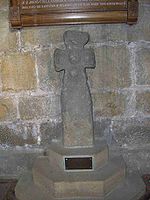
settlement within the Low Bradfield area with the discovery in 1870 of a Saxon cross in a field near the site of the former Cross Inn not far from the village centre. It has been examined by Sheffield University's
Phil Sidebottom who has compared it to similar crosses found in Staffordshire
that were put up in the middle of the 10th century. He says the cross’s hammer head design confirms that it dates to just before the Norman conquest
. The cross can now be seen in the nave
of St. Nicholas' Church
at High Bradfield.
it is inconceivable that it was not settled at that time and is believed to one of 16 unnamed Berewicks (an outlying part of a large manor
) within Hallamshire
that are mentioned. The hamlet of Low Bradfield grew up around the manorial corn mill which was established on the banks of the River Loxley
in the shadow of the local church
and castle at High Bradfield. The village developed as a farming community with much of the surrounding countryside set aside by the Norman lords as a deer hunting park. The Howard family
showed little interest in hunting and the deer were finally removed from the park in the 16th century.
when the Dale Dyke Dam
broke on March 11th, 1864. The original dam wall stood almost one mile west of the village. There was only one fatality in the village mainly because word had spread throughout the immediate area that there was a leak in the earth embankment and the community was partly prepared for the tragedy. The only death was a one day old infant, the offspring of Mr and Mrs Dawson, despite this the village was extensively damaged. Two stone bridges were swept away, as was the corn mill, blacksmith
’s shop, schoolroom, schoolmaster's house and a farmhouse. Samuel Harrison described the flood damage at Low Bradfield thus: “The destruction at Lower Bradfield is so thorough that the rock is torn up from under the foundation of the buildings.”
are situated close to the centre of the village. Fair House is a grade II* listed building and is one of the oldest structures in the area dating from the 1630s and was originally called Swinden House. Nether Farm is Grade II listed and dates from the 1820s. There are several other farms in the outlying areas. One of the great attractions to people from outside the village is the large centrally located recreation ground known as the Ibbotson Memorial Field which is a popular site for picnics and family visits and also serves as the village cricket ground, drawing large crowds to games on summer weekends. The field was named after the Ibbotson family who have lived in Low Bradfield for several centuries. The local tennis
and bowls
clubs also have facilities at the field.
There are several other notable buildings in the village. The former Wesleyan chapel on Mill Lee Road was built in 1817 and now serves as the offices for Bradfield Parish Council. Just across the road is another former Wesleyan chapel which was built in 1899 to replace its counterpart. It closed in 1993 and was sold for residential use. Also on Mill Lee Road are the former water board
filter houses which filtered water from the Agden, Dale Dike and Strines
reservoirs in Bradfield Dale. The filter houses were built in 1913 and extended in 1953 before being closed in 1995 when a new water treatment works was opened in the Loxley Valley. The buildings are derelict and unused at present. The Bradfield village hall, situated on the Memorial Field was completely rebuilt recently and re-opened in 2006.
There is just one public house
in the village, the Plough. There was a second pub called the Cross Inn which was situated at the foot of Woodfall Lane but this closed in the late 1970s and is now a private house. Just across the road is the village shop which is also the local post office
. The former Low Bradfield School is now a private residence which was built in 1867 to replace a school that was washed away in the flood of 1864 in a different part of the village. The school closed in 1985 with its pupils being transferred to nearby Dungworth School.
built a folly
tower overlooking Strines Reservoir
in 1927 known as Boot's Folly, it is a prominent landmark for miles around. Another ancient residence in the dale is Hallfield House
which dates from the Elizabethan era
and was the seat of the Greaveses, a very old Hallamshire
family. The dale also includes the Strines Inn public house.
South Yorkshire
South Yorkshire is a metropolitan county in the Yorkshire and the Humber region of England. It has a population of 1.29 million. It consists of four metropolitan boroughs: Barnsley, Doncaster, Rotherham, and City of Sheffield...
, England. It is situated within the boundary of the city of Sheffield
Sheffield
Sheffield is a city and metropolitan borough of South Yorkshire, England. Its name derives from the River Sheaf, which runs through the city. Historically a part of the West Riding of Yorkshire, and with some of its southern suburbs annexed from Derbyshire, the city has grown from its largely...
in the upper part of the Loxley Valley
River Loxley
The River Loxley is a river in the City of Sheffield South Yorkshire, England. Its source is a series of streams which rise some to the north-west of Sheffield on Bradfield Moors, and converge at Low Bradfield...
, 6¼ miles west-northwest of the city centre and just inside the northeast boundary of the Peak District
Peak District
The Peak District is an upland area in central and northern England, lying mainly in northern Derbyshire, but also covering parts of Cheshire, Greater Manchester, Staffordshire, and South and West Yorkshire....
National Park. Low Bradfield and the surrounding area is noted for its attractive countryside which draws many visitors from the more urban parts of Sheffield. At weekends the village can become quite crowded, especially when there is a match on the village cricket
Cricket
Cricket is a bat-and-ball game played between two teams of 11 players on an oval-shaped field, at the centre of which is a rectangular 22-yard long pitch. One team bats, trying to score as many runs as possible while the other team bowls and fields, trying to dismiss the batsmen and thus limit the...
pitch. Low Bradfield which stands in the shadow of Agden Reservoir
Agden Reservoir
Agden Reservoir is a water storage reservoir, situated at grid reference , west of the centre of Sheffield, South Yorkshire, England. It is owned by Yorkshire Water which is part of the Kelda Group...
has a sister village High Bradfield
High Bradfield
High Bradfield is a small village located north west of the centre of Sheffield in South Yorkshire, England at Grid Reference and within the city's boundaries...
which is located at a higher altitude, ½ mile to the northeast. The two villages are joined by the steep Woodfall Lane.
History
Early history
The earliest historical signs of settlement in the Bradfield area is an early to mid Bronze AgeBronze Age
The Bronze Age is a period characterized by the use of copper and its alloy bronze as the chief hard materials in the manufacture of some implements and weapons. Chronologically, it stands between the Stone Age and Iron Age...
ring cairn
Stone circle
A stone circle is a monument of standing stones arranged in a circle. Such monuments have been constructed across the world throughout history for many different reasons....
on Broomhead Moors, three miles to the northwest of Low Bradfield. This is believed to be a ritual or burial site from over 4,000 years ago. On the ridge between Bradfield Dale and the Ewden Valley is the Bar Dike, a 492 yards long trench with a rampart on its southern side which is 10 feet high in places. The dike is believed to have marked the boundary between different Dark Ages tribes in the period following the withdrawal of The Romans
Roman Empire
The Roman Empire was the post-Republican period of the ancient Roman civilization, characterised by an autocratic form of government and large territorial holdings in Europe and around the Mediterranean....
from Britain.
Anglo-Saxon cross
There is evidence of Anglo-SaxonAnglo-Saxon
Anglo-Saxon may refer to:* Anglo-Saxons, a group that invaded Britain** Old English, their language** Anglo-Saxon England, their history, one of various ships* White Anglo-Saxon Protestant, an ethnicity* Anglo-Saxon economy, modern macroeconomic term...
settlement within the Low Bradfield area with the discovery in 1870 of a Saxon cross in a field near the site of the former Cross Inn not far from the village centre. It has been examined by Sheffield University's
University of Sheffield
The University of Sheffield is a research university based in the city of Sheffield in South Yorkshire, England. It is one of the original 'red brick' universities and is a member of the Russell Group of leading research intensive universities...
Phil Sidebottom who has compared it to similar crosses found in Staffordshire
Staffordshire
Staffordshire is a landlocked county in the West Midlands region of England. For Eurostat purposes, the county is a NUTS 3 region and is one of four counties or unitary districts that comprise the "Shropshire and Staffordshire" NUTS 2 region. Part of the National Forest lies within its borders...
that were put up in the middle of the 10th century. He says the cross’s hammer head design confirms that it dates to just before the Norman conquest
Norman conquest of England
The Norman conquest of England began on 28 September 1066 with the invasion of England by William, Duke of Normandy. William became known as William the Conqueror after his victory at the Battle of Hastings on 14 October 1066, defeating King Harold II of England...
. The cross can now be seen in the nave
Nave
In Romanesque and Gothic Christian abbey, cathedral basilica and church architecture, the nave is the central approach to the high altar, the main body of the church. "Nave" was probably suggested by the keel shape of its vaulting...
of St. Nicholas' Church
Church of St. Nicholas, Bradfield
The Church of St. Nicholas, Bradfield is situated in the small village of High Bradfield which is located north west of the centre of the city of Sheffield in South Yorkshire, England. It is one of only five Grade One Listed buildings in Sheffield...
at High Bradfield.
Norman development
While Bradfied is not documented in the Domesday BookDomesday Book
Domesday Book , now held at The National Archives, Kew, Richmond upon Thames in South West London, is the record of the great survey of much of England and parts of Wales completed in 1086...
it is inconceivable that it was not settled at that time and is believed to one of 16 unnamed Berewicks (an outlying part of a large manor
Manorialism
Manorialism, an essential element of feudal society, was the organizing principle of rural economy that originated in the villa system of the Late Roman Empire, was widely practiced in medieval western and parts of central Europe, and was slowly replaced by the advent of a money-based market...
) within Hallamshire
Hallamshire
Hallamshire is the historical name for an area of South Yorkshire, England, in the current city of Sheffield.The origin of the name is uncertain. The English Place-Name Society describe "Hallam" originating from a formation meaning "on the rocks"...
that are mentioned. The hamlet of Low Bradfield grew up around the manorial corn mill which was established on the banks of the River Loxley
River Loxley
The River Loxley is a river in the City of Sheffield South Yorkshire, England. Its source is a series of streams which rise some to the north-west of Sheffield on Bradfield Moors, and converge at Low Bradfield...
in the shadow of the local church
Church of St. Nicholas, Bradfield
The Church of St. Nicholas, Bradfield is situated in the small village of High Bradfield which is located north west of the centre of the city of Sheffield in South Yorkshire, England. It is one of only five Grade One Listed buildings in Sheffield...
and castle at High Bradfield. The village developed as a farming community with much of the surrounding countryside set aside by the Norman lords as a deer hunting park. The Howard family
Howard family
The Howard family is an English aristocratic family founded by John Howard who was created Duke of Norfolk by Plantagenet monarch Richard III of England in 1483. However, John was also the eldest grandson of the 1st Duke of 1st creation...
showed little interest in hunting and the deer were finally removed from the park in the 16th century.
Great Sheffield Flood
Low Bradfield was the first populated place to be flooded by the Great Sheffield FloodGreat Sheffield Flood
Not to be confused with the floods in Sheffield in 2007.The Great Sheffield Flood was a flood that devastated parts of Sheffield, England, on 11 March 1864, when the Dale Dyke Dam broke.- Collapse of Dale Dyke Dam :...
when the Dale Dyke Dam
Dale Dike Reservoir
Dale Dike Reservoir or Dale Dyke Reservoir , famous for causing the Great Sheffield Flood, is in the north-east Peak District, in the City of Sheffield South Yorkshire, England, a mile west of Bradfield, eight miles from the centre of Sheffield, on the Dale Dike, a tributary of the River...
broke on March 11th, 1864. The original dam wall stood almost one mile west of the village. There was only one fatality in the village mainly because word had spread throughout the immediate area that there was a leak in the earth embankment and the community was partly prepared for the tragedy. The only death was a one day old infant, the offspring of Mr and Mrs Dawson, despite this the village was extensively damaged. Two stone bridges were swept away, as was the corn mill, blacksmith
Blacksmith
A blacksmith is a person who creates objects from wrought iron or steel by forging the metal; that is, by using tools to hammer, bend, and cut...
’s shop, schoolroom, schoolmaster's house and a farmhouse. Samuel Harrison described the flood damage at Low Bradfield thus: “The destruction at Lower Bradfield is so thorough that the rock is torn up from under the foundation of the buildings.”
Present day
Low Bradfield continues its tradition as a farming community into the present day. Cross Farm, Nether Farm and Fair House FarmFair House Farmhouse
Fair House Farmhouse is a 17th century building situated on Annet Lane in the village of Low Bradfield within the boundary of the City of Sheffield in South Yorkshire, England...
are situated close to the centre of the village. Fair House is a grade II* listed building and is one of the oldest structures in the area dating from the 1630s and was originally called Swinden House. Nether Farm is Grade II listed and dates from the 1820s. There are several other farms in the outlying areas. One of the great attractions to people from outside the village is the large centrally located recreation ground known as the Ibbotson Memorial Field which is a popular site for picnics and family visits and also serves as the village cricket ground, drawing large crowds to games on summer weekends. The field was named after the Ibbotson family who have lived in Low Bradfield for several centuries. The local tennis
Tennis
Tennis is a sport usually played between two players or between two teams of two players each . Each player uses a racket that is strung to strike a hollow rubber ball covered with felt over a net into the opponent's court. Tennis is an Olympic sport and is played at all levels of society at all...
and bowls
Bowls
Bowls is a sport in which the objective is to roll slightly asymmetric balls so that they stop close to a smaller "jack" or "kitty". It is played on a pitch which may be flat or convex or uneven...
clubs also have facilities at the field.
There are several other notable buildings in the village. The former Wesleyan chapel on Mill Lee Road was built in 1817 and now serves as the offices for Bradfield Parish Council. Just across the road is another former Wesleyan chapel which was built in 1899 to replace its counterpart. It closed in 1993 and was sold for residential use. Also on Mill Lee Road are the former water board
Water board
A water board is a regional organisation that has very different functions from one country to another, ranging from flood control, water resources management, water charging and financing, and bulk water supply.-Philippines:The...
filter houses which filtered water from the Agden, Dale Dike and Strines
Strines Reservoir
Strines Reservoir is a water storage reservoir situated at , it lies west of the centre of Sheffield in South Yorkshire, England.-Construction:...
reservoirs in Bradfield Dale. The filter houses were built in 1913 and extended in 1953 before being closed in 1995 when a new water treatment works was opened in the Loxley Valley. The buildings are derelict and unused at present. The Bradfield village hall, situated on the Memorial Field was completely rebuilt recently and re-opened in 2006.
There is just one public house
Public house
A public house, informally known as a pub, is a drinking establishment fundamental to the culture of Britain, Ireland, Australia and New Zealand. There are approximately 53,500 public houses in the United Kingdom. This number has been declining every year, so that nearly half of the smaller...
in the village, the Plough. There was a second pub called the Cross Inn which was situated at the foot of Woodfall Lane but this closed in the late 1970s and is now a private house. Just across the road is the village shop which is also the local post office
Post office
A post office is a facility forming part of a postal system for the posting, receipt, sorting, handling, transmission or delivery of mail.Post offices offer mail-related services such as post office boxes, postage and packaging supplies...
. The former Low Bradfield School is now a private residence which was built in 1867 to replace a school that was washed away in the flood of 1864 in a different part of the village. The school closed in 1985 with its pupils being transferred to nearby Dungworth School.
Bradfield Dale
The area to the west of the village is a rural area known as Bradfield Dale and contains the three reservoirs of Agden, Dale Dike and Strines which were constructed in the 1860s. The many construction workers who came into the dale prompted the Haychatter Farm to open a public house on its premises known as the Reservoir Inn and then the Haychatter which remained open until 2003. The dale contains Sugworth Hall which dates from a least the 16th century although the building has been much changed since then. Eminent families who have lived there include the Hooles and the Boots. Charles BootCharles Boot
Charles Boot of Sheffield, England was the creator and builder of Pinewood Studios on the estate of Heatherden Hall at Iver Heath in the parish of Iver in Buckinghamshire, England.- Basic biography :...
built a folly
Folly
In architecture, a folly is a building constructed primarily for decoration, but either suggesting by its appearance some other purpose, or merely so extravagant that it transcends the normal range of garden ornaments or other class of building to which it belongs...
tower overlooking Strines Reservoir
Strines Reservoir
Strines Reservoir is a water storage reservoir situated at , it lies west of the centre of Sheffield in South Yorkshire, England.-Construction:...
in 1927 known as Boot's Folly, it is a prominent landmark for miles around. Another ancient residence in the dale is Hallfield House
Hallfield House
Hallfield House is a Grade II listed building situated in Bradfield Dale, west of the village of Low Bradfield, near Sheffield in England.-History:...
which dates from the Elizabethan era
Elizabethan era
The Elizabethan era was the epoch in English history of Queen Elizabeth I's reign . Historians often depict it as the golden age in English history...
and was the seat of the Greaveses, a very old Hallamshire
Hallamshire
Hallamshire is the historical name for an area of South Yorkshire, England, in the current city of Sheffield.The origin of the name is uncertain. The English Place-Name Society describe "Hallam" originating from a formation meaning "on the rocks"...
family. The dale also includes the Strines Inn public house.