
High Bradfield
Encyclopedia
Sheffield
Sheffield is a city and metropolitan borough of South Yorkshire, England. Its name derives from the River Sheaf, which runs through the city. Historically a part of the West Riding of Yorkshire, and with some of its southern suburbs annexed from Derbyshire, the city has grown from its largely...
in South Yorkshire
South Yorkshire
South Yorkshire is a metropolitan county in the Yorkshire and the Humber region of England. It has a population of 1.29 million. It consists of four metropolitan boroughs: Barnsley, Doncaster, Rotherham, and City of Sheffield...
, England at Grid Reference and within the city's boundaries. The village lies just within the Peak District
Peak District
The Peak District is an upland area in central and northern England, lying mainly in northern Derbyshire, but also covering parts of Cheshire, Greater Manchester, Staffordshire, and South and West Yorkshire....
National Park, 1.3 miles (2 km) inside the parks north eastern border and is situated at an altitude of 260 metres (850 feet) and has extensive views across Bradfield Dale towards Derwent Edge
Derwent Edge
Derwent Edge is a Millstone Grit escarpment that lies above the Upper Derwent Valley in the Peak District National Park in the English county of Derbyshire...
and the Dark Peak
Dark Peak
The Dark Peak is the higher, wilder northern part of the Peak District in England.It gets its name because , the underlying limestone is covered by a cap of Millstone Grit which means that in winter the soil is almost always saturated with water...
. The most striking feature of the village is the Church of St. Nicholas, Bradfield
Church of St. Nicholas, Bradfield
The Church of St. Nicholas, Bradfield is situated in the small village of High Bradfield which is located north west of the centre of the city of Sheffield in South Yorkshire, England. It is one of only five Grade One Listed buildings in Sheffield...
, a Grade One Listed building originally dating from 1109. The name Bradfield translates from the Old English language as “Broad stretch of open countryside” and the area around the village is predominately grazing land with dairy and sheep farming dominating. High Bradfield has a sister village, Low Bradfield
Low Bradfield
Low Bradfield is a village within the in South Yorkshire, England. It is situated within the boundary of the city of Sheffield in the upper part of the Loxley Valley, 6¼ miles west-northwest of the city centre and just inside the northeast boundary of the Peak District National Park...
which lies less than 0.7 miles (1 km) to the south west but at a considerably lower altitude down in the upper Loxley valley. The two villages are linked by the steep Woodfall Lane.

History
High Bradfield, which was formerly known as kirkton, is not mentioned in the Domesday BookDomesday Book
Domesday Book , now held at The National Archives, Kew, Richmond upon Thames in South West London, is the record of the great survey of much of England and parts of Wales completed in 1086...
, but it may have been one of the 16 hamlets recorded in the manor of Hallam
Hallamshire
Hallamshire is the historical name for an area of South Yorkshire, England, in the current city of Sheffield.The origin of the name is uncertain. The English Place-Name Society describe "Hallam" originating from a formation meaning "on the rocks"...
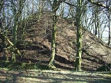
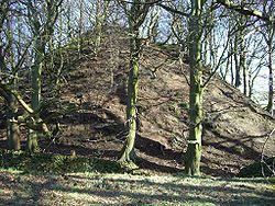
. On the northwest edge of the village, close to the church, is Bailey Hill, an approximately 10.5 metres (34.4 ft) high man-made conical mound that is a Scheduled Ancient Monument
Scheduled Ancient Monument
In the United Kingdom, a scheduled monument is a 'nationally important' archaeological site or historic building, given protection against unauthorized change. The various pieces of legislation used for legally protecting heritage assets from damage and destruction are grouped under the term...
. The date and purpose of its construction are unknown, though it has been interpreted as a Saxon fort, a Norman
Normans
The Normans were the people who gave their name to Normandy, a region in northern France. They were descended from Norse Viking conquerors of the territory and the native population of Frankish and Gallo-Roman stock...
Motte-and-bailey
Motte-and-bailey
A motte-and-bailey is a form of castle, with a wooden or stone keep situated on a raised earthwork called a motte, accompanied by an enclosed courtyard, or bailey, surrounded by a protective ditch and palisade...
castle, or a place of public village assembly. David Hey says there is no doubt that Bailey Hill is a motte-and-bailey castle calling it "One of the best preserved and most dramatic motte-and-baileys in Yorkshire." Excavations from 1720 revealed squared stones that had been produced by using tools. The eastern and southern flanks of the bailey is enclosed by a 95 metre long curving earthwork while to the west it is protected by steep slopes. About 500 metres (1,640.4 ft) to the southeast of the village is Castle Hill, a site is marked on old maps as a “supposed Saxon encampment” The site occupies a rocky ridge at the head of a high escarpment partially enclosed by ring work. The date or purpose of construction of this site is also unknown although it has been speculated that it was used a look out post.
The parish church, St Nicholas Church, is a Gothic Perpendicular style church dating from the 1480s. It incorporates elements of an earlier church that may have been built in the 12th century, and it may stand on the site of an Anglo-Saxon place of worship.
The Enclosure Act of the early 19th century altered the appearance of the countryside around High Bradfield as the profusion of stones in the soil resulted in many small fields in the area. Around the same time many people in the Bradfield area were influenced by the Industrial Revolution
Industrial Revolution
The Industrial Revolution was a period from the 18th to the 19th century where major changes in agriculture, manufacturing, mining, transportation, and technology had a profound effect on the social, economic and cultural conditions of the times...
and moved to nearby Sheffield to improve their standard of living. The Bradfield Parish workhouse was based in High Bradfield between 1759 and 1847, the building is still there today and stands across the road from the Old Horns pub on Jane Street, it is a private house today.
Present day
The present day village is still dominated by farming. Church Farm is a large dairy farm which supplies a large amount of milk for the surrounding area. Watt House Farm is also a dairy farm but is unique in that it is the home of the Bradfield Brewery, which is based in a converted barn on the farm. It brews several beers including Farmers Blonds and Pale Ale as well as some seasonal specials. There is one Public housePublic house
A public house, informally known as a pub, is a drinking establishment fundamental to the culture of Britain, Ireland, Australia and New Zealand. There are approximately 53,500 public houses in the United Kingdom. This number has been declining every year, so that nearly half of the smaller...
in the village the Old Horns Inn.