

List of Ohio covered bridges
Encyclopedia
This is a list of Ohio covered bridges. There are over 125 historic wooden covered bridge
s in the U.S. state
of Ohio
. Many are still in use. Ashtabula County
has 17 covered bridges, including a lattice truss bridge. Fairfield County
has 18 covered bridges.. The Smolen-Gulf Bridge, at 613 feet, is the longest in both Ohio and the United States. The West Liberty Covered Bridge
, at 18 feet, is the shortest in both.
Covered bridge
A covered bridge is a bridge with enclosed sides and a roof, often accommodating only a single lane of traffic. Most covered bridges are wooden; some newer ones are concrete or metal with glass sides...
s in the U.S. state
U.S. state
A U.S. state is any one of the 50 federated states of the United States of America that share sovereignty with the federal government. Because of this shared sovereignty, an American is a citizen both of the federal entity and of his or her state of domicile. Four states use the official title of...
of Ohio
Ohio
Ohio is a Midwestern state in the United States. The 34th largest state by area in the U.S.,it is the 7th‑most populous with over 11.5 million residents, containing several major American cities and seven metropolitan areas with populations of 500,000 or more.The state's capital is Columbus...
. Many are still in use. Ashtabula County
Ashtabula County, Ohio
Ashtabula County is the northeasternmost county in the state of Ohio. As of 2010, the population was 101,497, its county seat is Jefferson. The county is named for a Native American word meaning "river of many fish"....
has 17 covered bridges, including a lattice truss bridge. Fairfield County
Fairfield County, Ohio
Fairfield County is a county located in the state of Ohio, United States. As of 2010, the population was 146,156. Its county seat is Lancaster. Its name is a reference to the Fairfield area of the original Lancaster....
has 18 covered bridges.. The Smolen-Gulf Bridge, at 613 feet, is the longest in both Ohio and the United States. The West Liberty Covered Bridge
West Liberty Covered Bridge
The West Liberty Covered Bridge is a covered bridge which carries West Liberty Street across Cowles Creek in Geneva, Ohio, United States. At , it has been called the shortest covered bridge in the United States...
, at 18 feet, is the shortest in both.
List of Covered Bridges
| Name | Image | Location (in Ohio Ohio Ohio is a Midwestern state in the United States. The 34th largest state by area in the U.S.,it is the 7th‑most populous with over 11.5 million residents, containing several major American cities and seven metropolitan areas with populations of 500,000 or more.The state's capital is Columbus... ) |
Year Built | Notes |
|---|---|---|---|---|
| Adams Covered Bridge Adams Covered Bridge Adams Covered Bridge is a registered historic structure near Malta, Ohio, listed in the National Register on 1999-02-05. This wooden covered bridge was built in 1875.... |
Malta Malta, Ohio Malta is a village in Morgan County, Ohio, United States. The population was 696 at the 2000 census.-Geography:Malta is located at... , Morgan County Morgan County, Ohio **----... |
1875 | Also called San Toy Covered Bridge | |
| Armstrong Covered Bridge | Cambridge Cambridge, Ohio As of the census of 2000, there were 11,520 people, 4,924 households, and 2,954 families residing in the city. The population density was 2,055.1 people per square mile . There were 5,585 housing units of an average density of 996.3 per square mile... , Guernsey County Guernsey County, Ohio Guernsey County is a county located in the state of Ohio. As of 2010, the population was 40,087. Its county seat is Cambridge and is named for the Isle of Guernsey in the English Channel, from which many of the county's early settlers came.... |
1849 | Also called Clio Covered Bridge. Located in Cambridge Park | |
| Baker Covered Bridge | West Rushville, Fairfield County Fairfield County, Ohio Fairfield County is a county located in the state of Ohio, United States. As of 2010, the population was 146,156. Its county seat is Lancaster. Its name is a reference to the Fairfield area of the original Lancaster.... |
1871 | also called R.F. Baker Bridge | |
| Ballard Road Covered Bridge | Jasper Township, Greene County Greene County, Ohio Greene County is a county located in the state of Ohio, United States. The population was 161,573 in the 2010 Census. Its county seat is Xenia, and it was named for General Nathanael Greene, an officer in the Revolutionary War. Greene County was established on March 24, 1803.Greene County is part... |
1883 | ||
| Barkhurst Mill Covered Bridge | Marion Township Marion Township, Morgan County, Ohio Marion Township is one of the fourteen townships of Morgan County, Ohio, United States. The 2000 census found 1,336 people in the township, 1,031 of whom lived in the unincorporated portions of the township.-Geography:... , Morgan County Morgan County, Ohio **----... |
1872 | also known as Williams Covered Bridge | |
| Bay Covered Bridge | McArthur McArthur, Ohio McArthur is a village in Vinton County, Ohio, United States. The population was 1,888 at the 2000 census. It is the county seat of Vinton County.-Geography:McArthur is located at .... , Vinton County Vinton County, Ohio Vinton County is a county located in the state of Ohio, United States. As of the 2010 census, the population was 13,435. , the least populous in the state. Its county seat is McArthur. The county is named for Samuel Finley Vinton, a 19th-century United States Congressman from... |
1876 | also known as Tinker Covered Bridge | |
| Bell Covered Bridge | Barlow Township Barlow Township, Washington County, Ohio Barlow Township is one of the twenty-two townships of Washington County, Ohio, United States. The 2000 census found 2,417 people in the township.-Geography:Located in the western part of the county, it borders the following townships:... , Washington County Washington County, Ohio Washington County is a county located in the state of Ohio. As of the 2010 census, the population was 61,778. Its county seat is Marietta. The county, the oldest in the state, is named for George Washington. Washington County is included in the Parkersburg-Marietta-Vienna, West Virginia-Ohio... |
1888 | ||
| Benetka Road Covered Bridge Benetka Road Covered Bridge Benetka Road Bridge is a covered bridge spanning the Ashtabula River in Ashtabula County, Ohio, United States. The bridge, one of currently 16 drivable bridges in the county, is a single span Town truss design, with laminated arches being added during its renovation in 1985... |
Gageville, Ashtabula County Ashtabula County, Ohio Ashtabula County is the northeasternmost county in the state of Ohio. As of 2010, the population was 101,497, its county seat is Jefferson. The county is named for a Native American word meaning "river of many fish".... |
1900 | Over the Ashtabula River | |
| Bigelow Bridge Bigelow Bridge Bigelow Bridge is one of six historic covered bridges in Union County, Ohio. It crosses over the Little Darby Creek, at , on Axe Handle Road, just north of Ohio State Route 161 between Irwin and Chuckery.... |
Over the Little Darby Creek, Union County Union County, Ohio Union County is a county located in the US state of Ohio. As of the 2010 census, the population was 52,300. Increasingly becoming more of a suburban county, the population was estimated at 47,234 in 2007 by the U.S. Census Bureau... |
1873 | also called Little Darby Covered Bridge | |
| Blackwood Covered Bridge Covered bridges of southeast Ohio -Athens County:Athens County features three of these preserved structures:*Blackwood Covered BridgeThis is a bridge over the Middle Branch of the Shade River in Lodi Township. It is on Blackwood Road just east of its intersection with Zion Road . It is approximately seventy feet long... |
! |
Over the Middle Branch of the Shade River Shade River The Shade River is a tributary of the Ohio River in southeastern Ohio in the United States. Via the Ohio River, it is part of the watershed of the Mississippi River, draining an area of on the unglaciated portion of the Allegheny Plateau. The Shade River is long, or including its west... , Athens County Athens County, Ohio As of the census of 2000, there were 62,223 people, 22,501 households, and 12,713 families residing in the county. The population density was 123 people per square mile . There were 24,901 housing units at an average density of 49 per square mile... |
||
| Bridge of Dreams Bridge of Dreams The Bridge of Dreams is a 370 foot covered bridge located near Brinkhaven, Ohio. Originally built in the 1920s as a railroad bridge, and covered in 1998. It is the second longest covered bridge in Ohio after the Smolen–Gulf Bridge, and third longest covered bridge in the United States.-History:The... |
Brinkhaven, Knox County Knox County, Ohio Knox County is a county located in the state of Ohio, United States. As of 2010, the population was 60,921. Its county seat is Mount Vernon and is named for Henry Knox, an officer in the American Revolutionary War who was later the first Secretary of War.... |
1998 | Over the Mohican River Mohican River The Mohican River is a principal tributary of the Walhonding River, about 40 miles long, in north-central Ohio in the United States. Via the Walhonding, Muskingum and Ohio Rivers, it is part of the watershed of the Mississippi River, draining an area of 999 square miles .The Mohican River is... |
|
| Brown Bridge | New Hope, Brown County Brown County, Ohio As of the census of 2000, there were 42,285 people, 15,555 households, and 11,790 families residing in the county. The population density was 86 people per square mile . There were 17,193 housing units at an average density of 35 per square mile... |
1880 | Over the White Oak Creek | |
| Brubaker Bridge | Gratis, Preble County Preble County, Ohio As of the census of 2000, there were 42,337 people, 16,001 households, and 12,144 families residing in the county. The population density was 100 people per square mile . There were 17,186 housing units at an average density of 40 per square mile... |
1887 | Over Sims Run Creek | |
| Buckeye Bridge | Millersport, Fairfield County Fairfield County, Ohio Fairfield County is a county located in the state of Ohio, United States. As of 2010, the population was 146,156. Its county seat is Lancaster. Its name is a reference to the Fairfield area of the original Lancaster.... |
|||
| Burgstresser Bridge | Canal Winchester, Franklin County Franklin County, Ohio Franklin County is a county located in the state of Ohio, United States. In 2010 the population was 1,163,414, making it the second largest county in Ohio and the 34th largest county in population in the United States. Franklin County is also the largest in the eight-county Columbus, Ohio... |
1887 | Over Walnut Creek | |
| Caine Road Covered Bridge Caine Road Covered Bridge Caine Road Bridge is a covered bridge spanning the west branch of the Ashtabula River in Pierpont Township, Ashtabula County, Ohio, United States. The bridge, built in honor of Ashtabula County’s 175th anniversary, and one of currently 16 drivable bridges in the county, is a single span Pratt... |
_covered_bridge_1.jpg) |
Pierpont Township, Ashtabula County Ashtabula County, Ohio Ashtabula County is the northeasternmost county in the state of Ohio. As of 2010, the population was 101,497, its county seat is Jefferson. The county is named for a Native American word meaning "river of many fish".... |
1986 | Over the West Branch of the Ashtabula River |
| Charlton Mill Road Bridge | Wilberforce, Greene County Greene County, Ohio Greene County is a county located in the state of Ohio, United States. The population was 161,573 in the 2010 Census. Its county seat is Xenia, and it was named for General Nathanael Greene, an officer in the Revolutionary War. Greene County was established on March 24, 1803.Greene County is part... |
1883 | Over Massies Creek | |
| Christman Bridge | Eaton, Preble County Preble County, Ohio As of the census of 2000, there were 42,337 people, 16,001 households, and 12,144 families residing in the county. The population density was 100 people per square mile . There were 17,186 housing units at an average density of 40 per square mile... |
1895 | Over Sevenmile Creek | |
| Dixon Branch Covered Bridge | 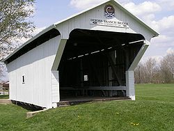 |
Lewisburg, Preble County Preble County, Ohio As of the census of 2000, there were 42,337 people, 16,001 households, and 12,144 families residing in the county. The population density was 100 people per square mile . There were 17,186 housing units at an average density of 40 per square mile... |
1887 | Moved from Salem Road (1/4 mile south) over Twin Creek |
| Doyle Road Covered Bridge Doyle Road Covered Bridge Doyle Road Bridge is a covered bridge spanning Mill Creek in Jefferson Township, Ashtabula County, Ohio, United States. The bridge, one of 16 drivable bridges in the county, is a single span Town truss design, with laminated arches added during its renovation in 1987... |
_covered_bridge_2.jpg) |
Jefferson, Ashtabula County Ashtabula County, Ohio Ashtabula County is the northeasternmost county in the state of Ohio. As of 2010, the population was 101,497, its county seat is Jefferson. The county is named for a Native American word meaning "river of many fish".... |
1876 | Over Mill Creek |
| Glen Helen Covered Bridge |  |
Yellow Springs, Greene County Greene County, Ohio Greene County is a county located in the state of Ohio, United States. The population was 161,573 in the 2010 Census. Its county seat is Xenia, and it was named for General Nathanael Greene, an officer in the Revolutionary War. Greene County was established on March 24, 1803.Greene County is part... |
1886 | also called Cemetery Road Covered Bridge, moved to Little Miami River in 1975 |
| Geeting Covered Bridge |  |
Lewisburg, Preble County Preble County, Ohio As of the census of 2000, there were 42,337 people, 16,001 households, and 12,144 families residing in the county. The population density was 100 people per square mile . There were 17,186 housing units at an average density of 40 per square mile... |
1894 | Over Price Creek |
| George Miller Road Covered Bridge | Byrd Township, Brown County Brown County, Ohio As of the census of 2000, there were 42,285 people, 15,555 households, and 11,790 families residing in the county. The population density was 86 people per square mile . There were 17,193 housing units at an average density of 35 per square mile... |
1879 | Over the West Fork of Eagle Creek | |
| Germantown Covered Bridge | Germantown, Montgomery County Montgomery County, Ohio Montgomery County is a county located in the state of Ohio, United States. The population was 535,153 in the 2010 Census. It was named in honor of Richard Montgomery, an American Revolutionary War general killed in 1775 while attempting to capture Quebec City, Canada. The county seat is Dayton... |
1865 | Bowstring suspension bridge of iron over Little Twin Creek | |
| Giddings Road Covered Bridge Giddings Road Covered Bridge Giddings Road Bridge is a covered bridge spanning Mill Creek in Jefferson Township, Ashtabula County, Ohio, United States. The bridge, one of currently 16 drivable bridges in the county, is a single span Pratt truss design, built with funding from an ODOT Timber Grant... |
_covered_bridge_1.jpg) |
Jefferson Township, Ashtabula County Ashtabula County, Ohio Ashtabula County is the northeasternmost county in the state of Ohio. As of 2010, the population was 101,497, its county seat is Jefferson. The county is named for a Native American word meaning "river of many fish".... |
1995 | Over Mill Creek |
| Graham Road Covered Bridge Graham Road Covered Bridge Graham Road Bridge is a covered bridge which formerly spanned the west branch of the Ashtabula River in Pierpont Township, Ashtabula County, Ohio, United States... |
Pierpont Township, Ashtabula County Ashtabula County, Ohio Ashtabula County is the northeasternmost county in the state of Ohio. As of 2010, the population was 101,497, its county seat is Jefferson. The county is named for a Native American word meaning "river of many fish".... |
1867 (restored 1913) | Defunct bridge; formerly spanned the west bank of the Ashtabula River, currently located at an Ashtabula County MetroPark. | |
| Hanaway Covered Bridge | Madison Township, Fairfield County Fairfield County, Ohio Fairfield County is a county located in the state of Ohio, United States. As of 2010, the population was 146,156. Its county seat is Lancaster. Its name is a reference to the Fairfield area of the original Lancaster.... |
1901 | also called Clearport Covered Bridge, Over Clear Creek | |
| Harpersfield Covered Bridge Harpersfield Covered Bridge Harpersfield Bridge is a covered bridge spanning the Grand River in Harpersfield Township, Ashtabula County, Ohio, United States. This double-span Howe truss bridge, one of currently 16 drivable covered bridges in the county, is the second longest covered bridge in Ohio at 228 feet... |
_covered_bridge_1.jpg) |
Harperfield, Ashtabula County Ashtabula County, Ohio Ashtabula County is the northeasternmost county in the state of Ohio. As of 2010, the population was 101,497, its county seat is Jefferson. The county is named for a Native American word meaning "river of many fish".... |
1868 | Over the Grand River |
| Harshman Bridge | Eaton, Preble County Preble County, Ohio As of the census of 2000, there were 42,337 people, 16,001 households, and 12,144 families residing in the county. The population density was 100 people per square mile . There were 17,186 housing units at an average density of 40 per square mile... |
1894 | Over Four Mile Creek | |
| Hartman Number Two Covered Bridge | Lockville, Fairfield County Fairfield County, Ohio Fairfield County is a county located in the state of Ohio, United States. As of 2010, the population was 146,156. Its county seat is Lancaster. Its name is a reference to the Fairfield area of the original Lancaster.... |
1888 | also called Lockville Park Covered Bridge, Over the Ohio Canal | |
| Island Run Bridge | York Township, Morgan County Morgan County, Ohio **----... |
1867 | also called Helmick Run Covered Bridge, Multiple Kingpost bridge over Island Run | |
| Jediah Hill Covered Bridge |  |
Springfield Township Springfield Township, Hamilton County, Ohio Springfield Township is one of the twelve townships of Hamilton County, Ohio, United States. The 2000 census found 37,587 people in the township.-Geography:Located in the northern part of the county, it has the following borders:... , Hamilton County Hamilton County, Ohio As of 2000, there were 845,303 people, 346,790 households, and 212,582 families residing in the county. The population density was 2,075 people per square mile . There were 373,393 housing units at an average density of 917 per square mile... |
1850 | |
| John Bright Covered Bridge | Lancaster, Fairfield County Fairfield County, Ohio Fairfield County is a county located in the state of Ohio, United States. As of 2010, the population was 146,156. Its county seat is Lancaster. Its name is a reference to the Fairfield area of the original Lancaster.... |
1881 | Over Fetters Run | |
| Johnston Covered Bridge | Revenge, Madison Township, Fairfield County Fairfield County, Ohio Fairfield County is a county located in the state of Ohio, United States. As of 2010, the population was 146,156. Its county seat is Lancaster. Its name is a reference to the Fairfield area of the original Lancaster.... |
1887 | Howe truss over Clear creek | |
| Jon Raab Covered Bridge | Colfax, Fairfield County Fairfield County, Ohio Fairfield County is a county located in the state of Ohio, United States. As of 2010, the population was 146,156. Its county seat is Lancaster. Its name is a reference to the Fairfield area of the original Lancaster.... |
1891 | ||
| Kidwell Covered Bridge Covered bridges of southeast Ohio -Athens County:Athens County features three of these preserved structures:*Blackwood Covered BridgeThis is a bridge over the Middle Branch of the Shade River in Lodi Township. It is on Blackwood Road just east of its intersection with Zion Road . It is approximately seventy feet long... |
Over Sunday Creek Sunday Creek Sunday Creek is a tributary of the Hocking River, 27.2 miles long, in southeastern Ohio in the United States. Via the Hocking and Ohio Rivers, it is part of the watershed of the Mississippi River, draining 139 square miles in a mainly rural area of the Allegheny Plateau region... near Redtown, Ohio Redtown, Ohio Redtown is an unincorporated community in Athens County, Ohio, United States. Redtown is located at the intersection of State Routes 13 and 685. The community is north of Chauncey and south of Jacksonville.... |
|||
| Lockport Covered Bridge | Lockport, Williams County Williams County, Ohio Williams County is a county located in the U.S. state of Ohio. As of 2010, the population was 37,642. Its county seat is Bryan and is named for David Williams, one of the captors of John André in the American Revolutionary War.-Geography:According to the U.S... |
1999 | ||
| Lynchburg Covered Bridge Lynchburg Covered Bridge The Lynchburg Covered Bridge is a historic wooden covered bridge that spans the east fork of the Little Miami River in Lynchburg, Ohio. It, also, has the distinction, following a recent repair and restoration project, of being the only such covered bridge in North America to have been converted to... |
 |
Lynchburg Lynchburg, Ohio Lynchburg is a village in Clinton and Highland counties in the U.S. state of Ohio. The population was 1,350 at the 2000 census.-Geography:Lynchburg is located at .... , Highland Highland County, Ohio As of the census of 2000, there were 40,875 people, 15,587 households, and 11,394 families residing in the county. The population density was 74 people per square mile . There were 17,583 housing units at an average density of 32 per square mile... and Clinton Clinton County, Ohio Clinton County is a county located in the state of Ohio, United States. As of the 2010 census, the population was 42,040. The 2008 Census Population Estimate places the figure at 43,200. It is named for former U.S. Vice-President George Clinton... Counties |
1870 | Spans the east fork of the Little Miami River Little Miami River The Little Miami River is a Class I tributary of the Ohio River that flows through five counties in southwestern Ohio in the United States. The Little Miami joins the Ohio River east of Cincinnati. It forms parts of the borders between Hamilton and Clermont counties and between Hamilton and Warren... |
| McCafferty Road Covered Bridge | Vera Cruz, Brown County Brown County, Ohio As of the census of 2000, there were 42,285 people, 15,555 households, and 11,790 families residing in the county. The population density was 86 people per square mile . There were 17,193 housing units at an average density of 35 per square mile... |
1877 | Over the East Fork of the Little Miami River | |
| McCleery Covered Bridge | Lancaster, Fairfield County Fairfield County, Ohio Fairfield County is a county located in the state of Ohio, United States. As of 2010, the population was 146,156. Its county seat is Lancaster. Its name is a reference to the Fairfield area of the original Lancaster.... |
1864 | ||
| Mechanicsville Road Covered Bridge Mechanicsville Road Covered Bridge Mechanicsville Road Bridge is a covered bridge spanning the Grand River in Austinburg Township, Ashtabula County, Ohio, United States. The bridge, one of currently 16 drivable bridges in the county, is the longest single span covered bridge in the county, and is believed to be the oldest in the... |
_covered_bridge_1.jpg) |
Mechanicsville, Ashtabula County Ashtabula County, Ohio Ashtabula County is the northeasternmost county in the state of Ohio. As of 2010, the population was 101,497, its county seat is Jefferson. The county is named for a Native American word meaning "river of many fish".... |
1867 | Over the Grand River |
| Middle Road Covered Bridge Middle Road Covered Bridge Middle Road Bridge is a covered bridge spanning Conneaut Creek in Conneaut, Ashtabula County, Ohio, United States. The bridge, one of currently 16 drivable bridges in the county, is a single span Howe truss design. Built in 1868, it was reconstructed in 1984 with the help of three volunteers and... |
Conneaut, Ashtabula County Ashtabula County, Ohio Ashtabula County is the northeasternmost county in the state of Ohio. As of 2010, the population was 101,497, its county seat is Jefferson. The county is named for a Native American word meaning "river of many fish".... |
1868 | Over Conneaut Creek | |
| Mink Hollow Covered Bridge | Madison Township, Fairfield County Fairfield County, Ohio Fairfield County is a county located in the state of Ohio, United States. As of 2010, the population was 146,156. Its county seat is Lancaster. Its name is a reference to the Fairfield area of the original Lancaster.... |
1887 | Over Arney Run | |
| Mull Covered Bridge | Fremont, Sandusky County Sandusky County, Ohio Sandusky County is a county in the U.S. state of Ohio. As of the 2010 census, the population was 60,944. Its county seat is Fremont and it is named for a native word meaning "water" .... |
1851 | Over Wolf Creek, Made obsolete by new bridge in 1962 and closed to traffic. | |
| Netcher Road Covered Bridge Netcher Road Covered Bridge Netcher Road Bridge is a covered bridge spanning water in Jefferson Township, Ashtabula County, Ohio, United States. The bridge, one of the newest and one of currently 16 drivable covered bridges in the county, is a single span constructed of timber arches with inverted Haupt walls, in a... |
Jefferson Township, Ashtabula County Ashtabula County, Ohio Ashtabula County is the northeasternmost county in the state of Ohio. As of 2010, the population was 101,497, its county seat is Jefferson. The county is named for a Native American word meaning "river of many fish".... |
1999 | ||
| New Hope Covered Bridge | New Hope, Brown County Brown County, Ohio As of the census of 2000, there were 42,285 people, 15,555 households, and 11,790 families residing in the county. The population density was 86 people per square mile . There were 17,193 housing units at an average density of 35 per square mile... |
1878 | Replaced the 1872 bridge over White Oak Creek | |
| North Pole Road Covered Bridge | Ripley, Brown County Brown County, Ohio As of the census of 2000, there were 42,285 people, 15,555 households, and 11,790 families residing in the county. The population density was 86 people per square mile . There were 17,193 housing units at an average density of 35 per square mile... |
1875 | also called Iron Bridge, Over Eagle Creek | |
| Olin's Covered Bridge Olin's Covered Bridge Olin's Bridge, or Olin Bridge, is a covered bridge that carries Dewey Road over the Ashtabula River in Plymouth Township, Ashtabula County, Ohio, United States. The bridge, one of currently 16 drivable bridges in the county, is a single span Town truss design, and is currently the only bridge in... |
Ashtabula, Ashtabula County Ashtabula County, Ohio Ashtabula County is the northeasternmost county in the state of Ohio. As of 2010, the population was 101,497, its county seat is Jefferson. The county is named for a Native American word meaning "river of many fish".... |
1873 | also called Dewey Road Covered Bridge, Over the Ashtabula River | |
| Palos Covered Bridge Covered bridges of southeast Ohio -Athens County:Athens County features three of these preserved structures:*Blackwood Covered BridgeThis is a bridge over the Middle Branch of the Shade River in Lodi Township. It is on Blackwood Road just east of its intersection with Zion Road . It is approximately seventy feet long... |
Over Sunday Creek Sunday Creek Sunday Creek is a tributary of the Hocking River, 27.2 miles long, in southeastern Ohio in the United States. Via the Hocking and Ohio Rivers, it is part of the watershed of the Mississippi River, draining 139 square miles in a mainly rural area of the Allegheny Plateau region... in Trimble Township Trimble Township, Athens County, Ohio Trimble Township is one of the fourteen townships of Athens County, Ohio, United States. The 2000 census found 4,710 people in the township, 1,728 of whom lived in the unincorporated portions of the township.-Geography:... |
|||
| Pugh's Mill Covered Bridge Pugh's Mill Covered Bridge (Butler County, Ohio) Pugh's Mill Covered Bridge is a registered historic structure near Oxford, Ohio, listed in the National Register on 1975-06-05. This wooden bridge was built in 1869 over Four Mile Creek and is the only remaining covered bridge in Butler County, Ohio.-External links:**- Notes :... |
 |
Oxford Oxford, Ohio Oxford is a city in northwestern Butler County, Ohio, United States, in the southwestern portion of the state. It lies in Oxford Township, originally called the College Township. The population was 21,943 at the 2000 census. This college town was founded as a home for Miami University. Oxford... , Butler County Butler County, Ohio Butler County is a county located in the state of Ohio, United States. As of 2010, the population was 368,130. Its county seat is Hamilton. It is named for General Richard Butler, who died in 1791 fighting Indians in northern Ohio. Butler's army marched out of Fort Hamilton, where the city of... |
1869 | also called Black Covered Bridge, Over Four Mile (Talawanda) Creek |
| Riverdale Road Covered Bridge Riverdale Road Covered Bridge Riverdale Road Bridge is a covered bridge spanning the Grand River in Morgan Township, Ashtabula County, Ohio, United States. The bridge, one of currently 16 drivable bridges in the county, is a single span Town truss design. During its renovation in 1981, the floor was rebuilt and glue-laminated... |
_covered_bridge_1.jpg) |
Rock Creek, Ashtabula County Ashtabula County, Ohio Ashtabula County is the northeasternmost county in the state of Ohio. As of 2010, the population was 101,497, its county seat is Jefferson. The county is named for a Native American word meaning "river of many fish".... |
1874 | Over the Grand River |
| Roberts Covered Bridge | Eaton, Preble County Preble County, Ohio As of the census of 2000, there were 42,337 people, 16,001 households, and 12,144 families residing in the county. The population density was 100 people per square mile . There were 17,186 housing units at an average density of 40 per square mile... |
1829 | Over Sevenmile Creek | |
| Rock Mill Covered Bridge | Rock Mill, Fairfield County Fairfield County, Ohio Fairfield County is a county located in the state of Ohio, United States. As of 2010, the population was 146,156. Its county seat is Lancaster. Its name is a reference to the Fairfield area of the original Lancaster.... |
1901 | Over the Hocking River | |
| Roley School Covered Bridge | Lancaster, Fairfield County Fairfield County, Ohio Fairfield County is a county located in the state of Ohio, United States. As of 2010, the population was 146,156. Its county seat is Lancaster. Its name is a reference to the Fairfield area of the original Lancaster.... |
1899 | At the county fair ground. | |
| Root Road Covered Bridge Root Road Covered Bridge Root Road Bridge is a covered bridge spanning the west branch of the Ashtabula River in Monroe Township, Ashtabula County, Ohio, United States. The bridge, one of currently 16 drivable bridges in the county, is a single span Town truss design. During its renovation in 1982-83, the bridge was... |
_covered_bridge_1.jpg) |
Keloggsville, Ashtabula County Ashtabula County, Ohio Ashtabula County is the northeasternmost county in the state of Ohio. As of 2010, the population was 101,497, its county seat is Jefferson. The county is named for a Native American word meaning "river of many fish".... |
1868 | Over the West Branch of the Ashtabula River |
| Scofield Covered Bridge | Brown County Brown County, Ohio As of the census of 2000, there were 42,285 people, 15,555 households, and 11,790 families residing in the county. The population density was 86 people per square mile . There were 17,193 housing units at an average density of 35 per square mile... |
1875 | Multiple kingpost with arch over Beetle Creek. | |
| Shryer Covered Bridge | west of Baltimore, Fairfield County Fairfield County, Ohio Fairfield County is a county located in the state of Ohio, United States. As of 2010, the population was 146,156. Its county seat is Lancaster. Its name is a reference to the Fairfield area of the original Lancaster.... |
1891 | ||
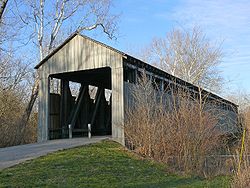
| Smolen-Gulf Bridge | 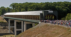 |
Ashtabula, Ashtabula County Ashtabula County, Ohio Ashtabula County is the northeasternmost county in the state of Ohio. As of 2010, the population was 101,497, its county seat is Jefferson. The county is named for a Native American word meaning "river of many fish".... |
2008 | also called "Number Seventeen", Modified Pratt Truss over the Ashtabula River |
| South Denmark Road Covered Bridge South Denmark Road Covered Bridge South Denmark Road Bridge is a covered bridge spanning Mill Creek in Denmark Township, Ashtabula County, Ohio, United States. The bridge, one of currently 16 drivable bridges in the county, is a single span Town truss design. Bypassed in 1975, the bridge still remains open to light traffic... |
_covered_bridge_1.jpg) |
Denmark Corner, Ashtabula County Ashtabula County, Ohio Ashtabula County is the northeasternmost county in the state of Ohio. As of 2010, the population was 101,497, its county seat is Jefferson. The county is named for a Native American word meaning "river of many fish".... |
1868 | Over Mill Creek |
| Stevenson Road Covered Bridge | Xenia, Greene County Greene County, Ohio Greene County is a county located in the state of Ohio, United States. The population was 161,573 in the 2010 Census. Its county seat is Xenia, and it was named for General Nathanael Greene, an officer in the Revolutionary War. Greene County was established on March 24, 1803.Greene County is part... |
1877 | Over Massies Creek | |
| State Road Covered Bridge State Road Covered Bridge State Road Bridge is a covered bridge spanning Conneaut Creek in Monroe Township, Ashtabula County, Ohio, United States. The bridge, one of currently 16 drivable bridges in the county, is a single span Town truss design. Constructed of of southern pine and oak, it features a window which extends... |
_covered_bridge_4.jpg) |
Conneaut, Ashtabula County Ashtabula County, Ohio Ashtabula County is the northeasternmost county in the state of Ohio. As of 2010, the population was 101,497, its county seat is Jefferson. The county is named for a Native American word meaning "river of many fish".... |
1983 | Over Conneaut Creek |
| Walter F. Ehrnfelt Bridge | Strongsville Strongsville, Ohio As of the census of 2000, there were 43,858 people, 16,209 households, and 12,383 families residing in the city. The population density was 1,779.6 people per square mile . There were 16,863 housing units at an average density of 684.2 per square mile... , Cuyahoga County Cuyahoga County, Ohio Cuyahoga County is a county located in the state of Ohio, United States. It is the most populous county in Ohio; as of the 2010 census, the population was 1,280,122. Its county seat is Cleveland. Cuyahoga County is part of Greater Cleveland, a metropolitan area, and Northeast Ohio, a... |
1983 | Over East Branch of the Rocky River Rocky River (Ohio) The Rocky River is a relatively short river which forms the western boundaries of the cities of Cleveland and Lakewood, Ohio. The city of Rocky River, on the west bank bordering Lakewood, is named after the river... in the Mill Stream Run reservation of the Cleveland Metroparks Cleveland Metroparks Cleveland Metroparks is an extensive system of nature preserves in Greater Cleveland, Ohio. The various reservations, which largely encircle the city of Cleveland, tend to follow the rivers and creeks that flow through the region... |
|
| Warnke Bridge | 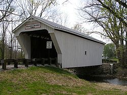 |
West Sonora, Preble County Preble County, Ohio As of the census of 2000, there were 42,337 people, 16,001 households, and 12,144 families residing in the county. The population density was 100 people per square mile . There were 17,186 housing units at an average density of 40 per square mile... |
1895 | Over Swamp Creek |
| West Liberty Covered Bridge West Liberty Covered Bridge The West Liberty Covered Bridge is a covered bridge which carries West Liberty Street across Cowles Creek in Geneva, Ohio, United States. At , it has been called the shortest covered bridge in the United States... |
Geneva, Ashtabula County Ashtabula County, Ohio Ashtabula County is the northeasternmost county in the state of Ohio. As of 2010, the population was 101,497, its county seat is Jefferson. The county is named for a Native American word meaning "river of many fish".... |
1867 | Over Cowles Creek | |
| Windsor Mills Covered Bridge Windsor Mills Covered Bridge Windsor Mills Bridge, also known as Wiswell Road Bridge or Warner Hollow Road Bridge, is a covered bridge that carries Covered Bridge Lane, formerly Wiswell Road, across Phelps Creek in Windsor Township, Ashtabula County, Ohio, United States. The bridge, one of currently 16 drivable bridges in the... |
_covered_bridge_1.jpg) |
Windsor Mills, Ashtabula County Ashtabula County, Ohio Ashtabula County is the northeasternmost county in the state of Ohio. As of 2010, the population was 101,497, its county seat is Jefferson. The county is named for a Native American word meaning "river of many fish".... |
1867 | also known as Wiswell Road Bridge or Warner Hollow Road Bridge, Town Truss over Phelps Creek |
| Zeller-Smith Covered Bridge | Pickerington, Fairfield County Fairfield County, Ohio Fairfield County is a county located in the state of Ohio, United States. As of 2010, the population was 146,156. Its county seat is Lancaster. Its name is a reference to the Fairfield area of the original Lancaster.... |
1906 | also called Sycamore Park Covered Bridge | |
| Arlington Boulevard Covered Bridge (Town lattice truss) | Newton Falls, Trumbull County Trumbull County, Ohio As of the census of 2000, there were 225,116 people, 89,020 households, and 61,690 families residing in the county. The population density was 365 people per square mile . There were 95,117 housing units at an average density of 154 per square mile... |
1831 | also called Newton Falls Covered Bridge, Over East Branch Mahoning River. (the second oldest covered bridge in Ohio) | |
See also
- List of Ashtabula County covered bridges
- List of Ohio-related topics
- Covered bridges of southeast OhioCovered bridges of southeast Ohio-Athens County:Athens County features three of these preserved structures:*Blackwood Covered BridgeThis is a bridge over the Middle Branch of the Shade River in Lodi Township. It is on Blackwood Road just east of its intersection with Zion Road . It is approximately seventy feet long...