
.gif)
Rocky River (Ohio)
Encyclopedia

River
A river is a natural watercourse, usually freshwater, flowing towards an ocean, a lake, a sea, or another river. In a few cases, a river simply flows into the ground or dries up completely before reaching another body of water. Small rivers may also be called by several other names, including...
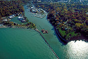
which forms the western boundaries of the cities of Cleveland
Cleveland, Ohio
Cleveland is a city in the U.S. state of Ohio and is the county seat of Cuyahoga County, the most populous county in the state. The city is located in northeastern Ohio on the southern shore of Lake Erie, approximately west of the Pennsylvania border...
and Lakewood, Ohio
Lakewood, Ohio
Lakewood is a city in Cuyahoga County, Ohio, United States. It is part of the Greater Cleveland Metropolitan Area, and borders the city of Cleveland. The population was 52,131 at the 2010 making it the third largest city in Cuyahoga County, behind Cleveland and Parma .Lakewood, one of Cleveland's...
. The city of Rocky River
Rocky River, Ohio
Rocky River is an affluent western suburb of Cleveland, Ohio, United States located in Cuyahoga County approximately nine miles west of Public Square in downtown Cleveland. The city is named for the river that forms its eastern border...
, on the west bank bordering Lakewood, is named after the river. The Rocky River was ranked by Field & Stream as one of the top steelhead trout rivers in the world, and has also been featured on ESPN.
Watershed
The river itself is formed by the confluence of the East and West Branches in North OlmstedNorth Olmsted, Ohio
-Business:Moen Incorporated, a fixture and faucet company, is headquartered in North Olmsted. CommutAir, a regional airline, has its operations center in North Olmsted....
at Cedar Point Hill (unrelated to the theme park
Cedar Point
Cedar Point is a 364 acre amusement park located in Sandusky, Ohio, United States on a narrow peninsula jutting into Lake Erie. Cedar Point is the only amusement park with four roller coasters that are taller than...
of the same name north of Sandusky
Sandusky, Ohio
Sandusky is a city in the U.S. state of Ohio and the county seat of Erie County. It is located in northern Ohio and is situated on the shores of Lake Erie, almost exactly half-way between Toledo to the west and Cleveland to the east....
), just west of Cleveland-Hopkins International Airport.
The headwaters of the larger West Branch are predominantly located in Medina County, and flows and northward through, among other locales, the town of Olmsted Falls
Olmsted Falls, Ohio
-External links:***...
. The East Branch first begins in the Cleveland suburb of North Royalton
North Royalton, Ohio
As of the census of 2000, there were 28,647 people, 11,250 households, and 7,695 families residing in the city. The population density was 1,345.9 people per square mile . There were 11,754 housing units at an average density of 552.2 per square mile...
, near State Rd. and Wallings Rd. Flow here is actually to the south, through Richfield
Richfield Township, Summit County, Ohio
Richfield Township is one of the nine townships of Summit County, Ohio, United States. The 2000 census found 5,424 people in the township, 2,138 of whom lived in the unincorporated portions of the township.-Geography:...
and Hinckley
Hinckley Township, Medina County, Ohio
Hinckley Township is one of the seventeen townships of Medina County, Ohio, United States, located in the northeast corner of the county. The 2000 census found 6,753 people in the township.-Geography:...
Townships. The East Branch wraps around Whipp's Ledges in Hinckley Township, and begins its north-northwest journey. Hinckley Lake is actually the East Branch Rocky, impounded in the late 1920s/early 1930s. On its course back through southwestern Cuyahoga County
Cuyahoga County, Ohio
Cuyahoga County is a county located in the state of Ohio, United States. It is the most populous county in Ohio; as of the 2010 census, the population was 1,280,122. Its county seat is Cleveland. Cuyahoga County is part of Greater Cleveland, a metropolitan area, and Northeast Ohio, a...
, the East Branch is an important local feature in the cities of Strongsville
Strongsville, Ohio
As of the census of 2000, there were 43,858 people, 16,209 households, and 12,383 families residing in the city. The population density was 1,779.6 people per square mile . There were 16,863 housing units at an average density of 684.2 per square mile...
and Berea
Berea, Ohio
- History :The first European settlers were originally from Connecticut. Berea fell within Connecticut's Western Reserve and was surveyed and divided into townships and ranges by one Gideon Granger, a gentleman who served as Postmaster General under President Thomas Jefferson...
.
The lower portions of both branches and the mainstem Rocky River flow through a V-shaped valley; the valley and the river are part of the Cleveland Metroparks
Cleveland Metroparks
Cleveland Metroparks is an extensive system of nature preserves in Greater Cleveland, Ohio. The various reservations, which largely encircle the city of Cleveland, tend to follow the rivers and creeks that flow through the region...
system. The Rocky River valley is heavily forested, and a parkway
Parkway
The term parkway has several distinct principal meanings and numerous synonyms around the world, for either a type of landscaped area or a type of road.Type of landscaped area:...
along the river provides access to many different activities available in the park. Given the heavy population density of Cleveland and its older suburb
Suburb
The word suburb mostly refers to a residential area, either existing as part of a city or as a separate residential community within commuting distance of a city . Some suburbs have a degree of administrative autonomy, and most have lower population density than inner city neighborhoods...
s, many of which border on the valley, the valley provides a popular location for recreational activities that would be difficult in other parts of the city.
Pollution
Unlike other rivers in Northeast Ohio, the Rocky is largely free from industrial pollutionPollution
Pollution is the introduction of contaminants into a natural environment that causes instability, disorder, harm or discomfort to the ecosystem i.e. physical systems or living organisms. Pollution can take the form of chemical substances or energy, such as noise, heat or light...
and maintains a rustic character that is surprising, given its proximity to Cleveland and its suburbs. This is because most of its sources are in agricultural and suburban areas, which results in natural organic pollution and sewage, resulting in higher bacteria levels than rivers downstream from industrial discharges.
Crossings and tributaries
Lake Erie
Lake Erie is the fourth largest lake of the five Great Lakes in North America, and the tenth largest globally. It is the southernmost, shallowest, and smallest by volume of the Great Lakes and therefore also has the shortest average water residence time. It is bounded on the north by the...
, at times approaching 150 feet (45.7 m) below the ground level on either side of the valley. This depth has required several high-level and low-level bridge
Bridge
A bridge is a structure built to span physical obstacles such as a body of water, valley, or road, for the purpose of providing passage over the obstacle...
s to cross the valley between Lakewood
Lakewood, Ohio
Lakewood is a city in Cuyahoga County, Ohio, United States. It is part of the Greater Cleveland Metropolitan Area, and borders the city of Cleveland. The population was 52,131 at the 2010 making it the third largest city in Cuyahoga County, behind Cleveland and Parma .Lakewood, one of Cleveland's...
and Rocky River
Rocky River, Ohio
Rocky River is an affluent western suburb of Cleveland, Ohio, United States located in Cuyahoga County approximately nine miles west of Public Square in downtown Cleveland. The city is named for the river that forms its eastern border...
and between Cleveland
Cleveland, Ohio
Cleveland is a city in the U.S. state of Ohio and is the county seat of Cuyahoga County, the most populous county in the state. The city is located in northeastern Ohio on the southern shore of Lake Erie, approximately west of the Pennsylvania border...
and Fairview Park
Fairview Park, Ohio
-Demographics:As of the census of 2000, there were 420,690 people, 7,856 households, and 4,713 families residing in the city. The population density was 3,742.2 people per square mile . There were 8,152 housing units at an average density of 1,736.1 per square mile...
.
Several of the low-level bridges which cross the river within the valley are subject to closure and flooding during and after heavy storms, but these low-level bridges are mostly used by local traffic on the Valley Parkway which follows Rocky River's course, and crossing it several times.
From North mouth upstream to South source:
| ID National Bridge Inventory The National Bridge Inventory is a database, compiled by the Federal Highway Administration, with information on all bridges and tunnels in the United States that have roads passing above or below. This is similar to the grade crossing identifier number database compiled by the Federal Railroad... |
Name |
GNIS Geographic Names Information System The Geographic Names Information System is a database that contains name and locative information about more than two million physical and cultural features located throughout the United States of America and its territories. It is a type of gazetteer... |
Coordinates Geographic coordinate system A geographic coordinate system is a coordinate system that enables every location on the Earth to be specified by a set of numbers. The coordinates are often chosen such that one of the numbers represent vertical position, and two or three of the numbers represent horizontal position... |
Elevation Elevation The elevation of a geographic location is its height above a fixed reference point, most commonly a reference geoid, a mathematical model of the Earth's sea level as an equipotential gravitational surface .... |
Year Built |
Length |
Carries |
|---|---|---|---|---|---|---|---|
| West Channel Rocky River | [ 1072305] | 41°29′11"N 81°50′7"W | 581 feet (177.1 m) | ||||
| 1800639 | Clifton Park-West Lake | 1964 | 1139 feet (347.2 m) |  U.S. Route 6 U.S. Route 6U.S. Route 6 U.S. Route 6 , also called the Grand Army of the Republic Highway, a name that honors an American Civil War veterans association, is a main route of the U.S. Highway system, running east-northeast from Bishop, California to Provincetown, Massachusetts. Until 1964, it continued south from Bishop to... ,  Ohio State Route 2, Ohio State Route 2, Ohio State Route 254 Ohio State Route 254Ohio State Route 254 State Route 254 is an east–west state route in northern Ohio. The route begins at State Route 57 in Lorain and ends at U.S. Route 20 in Lakewood. SR 254 intersects Interstate 90 twice, both times near its endpoints... |
|||
| Nickel Plate Road | Norfolk Southern Railway Norfolk Southern Railway The Norfolk Southern Railway is a Class I railroad in the United States, owned by the Norfolk Southern Corporation. With headquarters in Norfolk, Virginia, the company operates 21,500 route miles in 22 eastern states, the District of Columbia and the province of Ontario, Canada... |
||||||
| 1801074 | Detroit Avenue | [ 1073890] | 41°28′57"N 81°49′52"W | 568 feet (173.1 m) | 1980 | 640 feet (195.1 m) |  U.S. Route 6A U.S. Route 6AU.S. Route 6A U.S. Route 6A or U.S. Route 6 Alternate may refer to:*U.S. Route 6A *U.S. Route 6 Alternate *U.S. Route 6A... ,  U.S. Route 20 U.S. Route 20U.S. Route 20 U.S. Route 20 is an east–west United States highway. As the "0" in its route number implies, US 20 is a coast-to-coast route. Spanning , it is the longest road in the United States, and the route sparsely parallels Interstate 90... ,  Ohio State Route 113 Ohio State Route 113 |
| Valley Parkway | |||||||
| 1808567 | 1971 | 839 feet (255.7 m) |  I-90 I-90Interstate 90 Interstate 90 is the longest Interstate Highway in the United States at . It is the northernmost coast-to-coast interstate, and parallels US 20 for the most part. Its western terminus is in Seattle, at Edgar Martinez Drive S. near Safeco Field and CenturyLink Field, and its eastern terminus is in... |
||||
| 1830147 | Hilliard Avenue | 1925 | 860 feet (262.1 m) | former U.S. Route 20 U.S. Route 20 U.S. Route 20 is an east–west United States highway. As the "0" in its route number implies, US 20 is a coast-to-coast route. Spanning , it is the longest road in the United States, and the route sparsely parallels Interstate 90... , Cuyahoga County Route 69 |
|||
| old Valley Parkway ford | |||||||
| Valley Parkway | |||||||
| Valley Parkway | |||||||
| 1801325 | Lorain Road | 1935 | 1230 feet (374.9 m) |  Ohio State Route 10 Ohio State Route 10 |
|||
| Old Lorain Road | |||||||
| 1831623 | Puritas Road | 1977 | 195 feet (59.4 m) | Cuyahoga County Route 189 | |||
| 1812831 | 1970 | 1571 feet (478.8 m) |  I-480 I-480Interstate 480 (Ohio) Interstate 480 is a loop highway that connects the Ohio Turnpike with suburban Cleveland, Ohio. The highway is officially designated the Outerbelt South Freeway, but it is rarely referred to by that name.... |
||||
| 1802046 | Brookpark Road | 1933 | 1919 feet (584.9 m) |  Ohio State Route 17 Ohio State Route 17 |
|||
| Abram Creek | [ 1037303] | 41°25′4"N 81°51′59"W | 640 feet (195.1 m) | ||||
| Valley Parkway | |||||||
| 1830643 | Cedar Point Road | 1929 | 62 feet (18.9 m) | Cuyahoga County Route 193 | |||
| West Branch Rocky River | [ 1067044] | 41°24′23"N 81°53′13"W | 659 feet (200.9 m) | ||||
| East Branch Rocky River | [ 1066697] | 41°24′22"N 81°53′14"W | 656 feet (199.9 m) | ||||