

List of Ashtabula County covered bridges
Encyclopedia

Covered bridge
A covered bridge is a bridge with enclosed sides and a roof, often accommodating only a single lane of traffic. Most covered bridges are wooden; some newer ones are concrete or metal with glass sides...
s in Ashtabula County
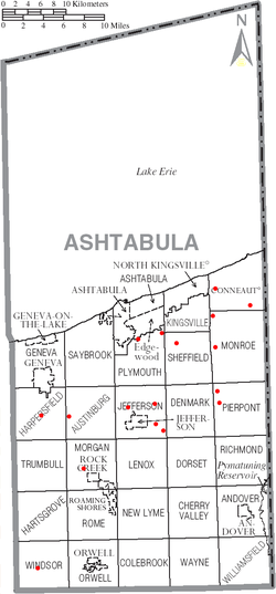
Ashtabula County, Ohio
Ashtabula County is the northeasternmost county in the state of Ohio. As of 2010, the population was 101,497, its county seat is Jefferson. The county is named for a Native American word meaning "river of many fish"....
, Ohio
Ohio
Ohio is a Midwestern state in the United States. The 34th largest state by area in the U.S.,it is the 7th‑most populous with over 11.5 million residents, containing several major American cities and seven metropolitan areas with populations of 500,000 or more.The state's capital is Columbus...
, USA
United States
The United States of America is a federal constitutional republic comprising fifty states and a federal district...
. Ashtabula County has the most public covered bridges – currently 17 – of any county in Ohio, with six having been newly constructed since 1983. Self-driven tours of the bridges can be had any time of the year by following signs posted in the county.
Public, drivable covered bridges
| Crossing | Built | Coordinates |
|---|---|---|
| Benetka Road Covered Bridge Benetka Road Covered Bridge Benetka Road Bridge is a covered bridge spanning the Ashtabula River in Ashtabula County, Ohio, United States. The bridge, one of currently 16 drivable bridges in the county, is a single span Town truss design, with laminated arches being added during its renovation in 1985... |
~1900 | 41°50′55.104"N 80°41′21.948"W |
| Caine Road Covered Bridge Caine Road Covered Bridge Caine Road Bridge is a covered bridge spanning the west branch of the Ashtabula River in Pierpont Township, Ashtabula County, Ohio, United States. The bridge, built in honor of Ashtabula County’s 175th anniversary, and one of currently 16 drivable bridges in the county, is a single span Pratt... |
1986 | 41°45′53.46"N 80°37′3.648"W |
| Creek Road Covered Bridge Creek Road Covered Bridge Creek Road Bridge is a covered bridge spanning Conneaut Creek in Conneaut, Ashtabula County, Ohio, United States. The bridge, one of currently 16 drivable bridges in the county, is a single span Town truss design... |
1994 | 41°55′10.884"N 80°36′34.812"W |
| Doyle Road Covered Bridge Doyle Road Covered Bridge Doyle Road Bridge is a covered bridge spanning Mill Creek in Jefferson Township, Ashtabula County, Ohio, United States. The bridge, one of 16 drivable bridges in the county, is a single span Town truss design, with laminated arches added during its renovation in 1987... |
1868 | 41°45′43.632"N 80°47′24.612"W |
| Giddings Road Covered Bridge Giddings Road Covered Bridge Giddings Road Bridge is a covered bridge spanning Mill Creek in Jefferson Township, Ashtabula County, Ohio, United States. The bridge, one of currently 16 drivable bridges in the county, is a single span Pratt truss design, built with funding from an ODOT Timber Grant... |
1995 | 41°45′53.424"N 80°43′57.36"W |
| Harpersfield Covered Bridge Harpersfield Covered Bridge Harpersfield Bridge is a covered bridge spanning the Grand River in Harpersfield Township, Ashtabula County, Ohio, United States. This double-span Howe truss bridge, one of currently 16 drivable covered bridges in the county, is the second longest covered bridge in Ohio at 228 feet... |
1868 | 41.75589°N 80.94433°W |
| Mechanicsville Road Covered Bridge Mechanicsville Road Covered Bridge Mechanicsville Road Bridge is a covered bridge spanning the Grand River in Austinburg Township, Ashtabula County, Ohio, United States. The bridge, one of currently 16 drivable bridges in the county, is the longest single span covered bridge in the county, and is believed to be the oldest in the... |
1867 | 41°45′16.632"N 80°53′52.584"W |
| Middle Road Covered Bridge Middle Road Covered Bridge Middle Road Bridge is a covered bridge spanning Conneaut Creek in Conneaut, Ashtabula County, Ohio, United States. The bridge, one of currently 16 drivable bridges in the county, is a single span Howe truss design. Built in 1868, it was reconstructed in 1984 with the help of three volunteers and... |
1868 | 41°54′7.488"N 80°32′49.092"W |
| Netcher Road Covered Bridge Netcher Road Covered Bridge Netcher Road Bridge is a covered bridge spanning water in Jefferson Township, Ashtabula County, Ohio, United States. The bridge, one of the newest and one of currently 16 drivable covered bridges in the county, is a single span constructed of timber arches with inverted Haupt walls, in a... |
1998 | 41°44′13.416"N 80°43′54.084"W |
| Olin's Covered Bridge Olin's Covered Bridge Olin's Bridge, or Olin Bridge, is a covered bridge that carries Dewey Road over the Ashtabula River in Plymouth Township, Ashtabula County, Ohio, United States. The bridge, one of currently 16 drivable bridges in the county, is a single span Town truss design, and is currently the only bridge in... |
1873 | 41°51′45.648"N 80°43′15.204"W |
| Riverdale Road Covered Bridge Riverdale Road Covered Bridge Riverdale Road Bridge is a covered bridge spanning the Grand River in Morgan Township, Ashtabula County, Ohio, United States. The bridge, one of currently 16 drivable bridges in the county, is a single span Town truss design. During its renovation in 1981, the floor was rebuilt and glue-laminated... |
1874 | 41°40′23.808"N 80°52′18.66"W |
| Root Road Covered Bridge Root Road Covered Bridge Root Road Bridge is a covered bridge spanning the west branch of the Ashtabula River in Monroe Township, Ashtabula County, Ohio, United States. The bridge, one of currently 16 drivable bridges in the county, is a single span Town truss design. During its renovation in 1982-83, the bridge was... |
1868 | 41°50′0.0342"N 80°37′12.2844"W |
| South Denmark Road Covered Bridge South Denmark Road Covered Bridge South Denmark Road Bridge is a covered bridge spanning Mill Creek in Denmark Township, Ashtabula County, Ohio, United States. The bridge, one of currently 16 drivable bridges in the county, is a single span Town truss design. Bypassed in 1975, the bridge still remains open to light traffic... |
1895 | 41°43′1.956"N 80°41′25.332"W |
| Smolen–Gulf Bridge | 2008 | 41°51′19.584"N 80°45′43.74"W |
| State Road Covered Bridge State Road Covered Bridge State Road Bridge is a covered bridge spanning Conneaut Creek in Monroe Township, Ashtabula County, Ohio, United States. The bridge, one of currently 16 drivable bridges in the county, is a single span Town truss design. Constructed of of southern pine and oak, it features a window which extends... |
1983 | 41°53′11.4"N 80°37′14.412"W |
| West Liberty Covered Bridge West Liberty Covered Bridge The West Liberty Covered Bridge is a covered bridge which carries West Liberty Street across Cowles Creek in Geneva, Ohio, United States. At , it has been called the shortest covered bridge in the United States... |
2010–2011 | 41°47′56.94"N 80°56′54.6"W |
| Windsor Mills Covered Bridge Windsor Mills Covered Bridge Windsor Mills Bridge, also known as Wiswell Road Bridge or Warner Hollow Road Bridge, is a covered bridge that carries Covered Bridge Lane, formerly Wiswell Road, across Phelps Creek in Windsor Township, Ashtabula County, Ohio, United States. The bridge, one of currently 16 drivable bridges in the... |
1867 | 41°31′59.448"N 80°57′50.112"W |
Former and other bridges
- Graham Road BridgeGraham Road Covered BridgeGraham Road Bridge is a covered bridge which formerly spanned the west branch of the Ashtabula River in Pierpont Township, Ashtabula County, Ohio, United States...
- The South Ridge Road Covered Bridge spanned the Conneaut CreekConneaut CreekConneaut Creek is a tributary of Lake Erie in northwestern Pennsylvania and northeastern Ohio in the United States. Via Lake Erie, the Niagara River and Lake Ontario, it is part of the watershed of the St...
in KingsvilleKingsville, OhioKingsville is a census-designated place in central Kingsville Township, Ashtabula County, Ohio, United States. Although it is unincorporated, it has a post office, with the ZIP code of 44048...
. - In Kellogsville there were four covered bridges over the Ashtabula RiverAshtabula RiverThe Ashtabula River is a river located northeast of Cleveland in Ohio. The river flows into Lake Erie at the city of Ashtabula, Ohio. It is 40 mi in length and drains 137 mi² .-Name:...
within four miles of each other. - The Pierpont Covered Bridge was north of PierpontPierpont, OhioPierpont is an unincorporated community in central Pierpont Township, Ashtabula County, Ohio, United States. Although it is unincorporated, it has a post office, with the ZIP code of 44082. It lies at the intersection of State Routes 7 and 167.-References:...
on State Route 7. - The Callender Road Covered Bridge, lost in the flood of 1913, spanned the Grand RiverGrand River (Ohio)The Grand River is a tributary of Lake Erie, 102.7 miles long, in northeastern Ohio in the United States. Via Lake Erie, the Niagara River and Lake Ontario, it is part of the watershed of the St. Lawrence River, which flows to the Atlantic Ocean...
near Rock CreekRock Creek, OhioRock Creek is a village in Ashtabula County, Ohio, United States. The population was 584 at the 2000 census.The principal village festival is the Ox Roast...
. - The Muller Covered Bridge in JeffersonJefferson, OhioJefferson is a village in Ashtabula County, Ohio, United States. The population was 3,572 at the 2000 census. It is the county seat of Ashtabula County. Modern-day Jefferson sports the world's only perambulator museum and a historical complex including several restored 18th century buildings....
. - A two-lane covered bridge was located on State Route 45 in Rock Creek; after a century it was replaced in 1948.
- The Old Route 7 Covered Bridge, over the Conneaut Creek in what is now ConneautConneaut, OhioAs of the census of 2000, there were 12,485 people, 5,038 households, and 3,410 families residing in the city. The population density was 473.4 people per square mile . There were 5,710 housing units at an average density of 216.5 per square mile...
was built in 1867 and replaced in 1925. - The Twin Covered Bridges of Farnham spanned the Conneaut Creek in what is now Conneaut.
- The Kelloggsville Covered Bridge spanned the Ashtabula River south of Kelloggsville.
- The Prim's Sawmill Covered Bridge.
- The Forman Road Covered Bridge in Eagleville (near AustinburgAustinburg, OhioAustinburg is a census-designated place in northern Austinburg Township, Ashtabula County, Ohio, United States. Although it is unincorporated, it has a post office, with the ZIP code of 44010. It lies at the intersection of State Routes 45 and 307....
) is now part of Covered Bridge Pizza in North KingsvilleNorth Kingsville, OhioNorth Kingsville is a village in Ashtabula County, Ohio, United States. The population was 2,658 at the 2000 census.-Geography:North Kingsville is located at ....
and AndoverAndover, OhioAndover is a village located in the south-east of Ashtabula County, Ohio, United States. The population was 1,269 at the 2000 census.The closest village to the Ohio side of Pymatuning State Park, the settlement supports a regional tourism industry...
; In 1974, the 123-ft. Town lattice structure, which had been built in 1862 was sold for $5.00, cut in half, dismantled, and reassembled in the two locations. - The Fobes Road Covered Bridge or Shaunghum Covered Bridge was a 118-foot Town lattice structure that carried Fobes Road over the Grand River in Ashtabula County, Ohio. Built in 1911, the bridge was unique in that it was built without abutments, but rather sat on wooden pilings. In the 1960s a runaway truck struck the south portal of the bridge, causing severe damage that forced the bridge's permanent closure. In May 1971, the bridge was deliberately burned by Ashtabula County officials. WGCB No. 35-04-21.
- The Furnace Road Covered Bridge spanned Conneaut Creek in Conneaut.
- The Crooked Gulf Covered Bridge was the first one one to span the Ashtabula River.
- The Wayne Township Covered Bridge was on U.S. Route 322.
- The South Windsor Covered Bridge carried South Windsor Road across the Grand River in Windsor Township, Ashtabula County Ohio. Built in 1870, the 90-foot Town lattice structure was destroyed by fire on the night of October 2, 1970. The fire was determined to be an act of arson, during which the perpetrator(s) piled tires within the bridge and set them afire. WGCB No. 35-04-26.
Ashtabula County has had 62 covered bridges.