

List of National Natural Landmarks in Pennsylvania
Encyclopedia
From List of National Natural Landmarks, these are the National Natural Landmark
s in Pennsylvania
. There are 27 in total, X are lakes or pond, Y are forests, Z are other.
National Natural Landmark
The National Natural Landmark program recognizes and encourages the conservation of outstanding examples of the natural history of the United States. It is the only natural areas program of national scope that identifies and recognizes the best examples of biological and geological features in...
s in Pennsylvania
Pennsylvania
The Commonwealth of Pennsylvania is a U.S. state that is located in the Northeastern and Mid-Atlantic regions of the United States. The state borders Delaware and Maryland to the south, West Virginia to the southwest, Ohio to the west, New York and Ontario, Canada, to the north, and New Jersey to...
. There are 27 in total, X are lakes or pond, Y are forests, Z are other.
| Name | Image | Date | Location | County | Description | |
|---|---|---|---|---|---|---|
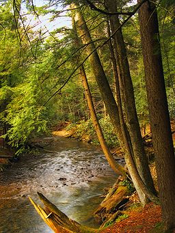
| 1 | Bear Meadows Natural Area Bear Meadows Natural Area Bear Meadows Natural Area is located in Centre County, Pennsylvania, USA, four miles south of Boalsburg, within Rothrock State Forest in the Appalachian Mountains. The area contains a bog surrounded by steep mountains and hiking trails... |
1965 | Four miles south of Boalsburg Boalsburg, Pennsylvania Boalsburg is a census-designated place in Centre County, Pennsylvania, United States. It is part of the State College, Pennsylvania Metropolitan Statistical Area. The population was 3,578 at the 2000 census. The village claims to be the birthplace of Memorial Day. The name Boalsburg comes from... , within Rothrock State Forest Rothrock State Forest Rothrock State Forest is a Pennsylvania state forest in Pennsylvania Bureau of Forestry District #5. The main offices are located in Huntingdon in Huntingdon County, Pennsylvania in the United States.... 40.406111°N 77.173889°W |
Centre Centre County, Pennsylvania Centre County is a county located in the U.S. state of Pennsylvania. It is part of the State College, Pennsylvania Metropolitan Statistical Area. As of 2010, the population was 153,990.... |
||
| 2 | Box Huckleberry Site Hoverter and Sholl Box Huckleberry Natural Area Hoverter and Sholl Box Huckleberry Natural Area is a natural area in Perry County, Pennsylvania, near New Bloomfield, which protects a colony of box huckleberry over 1,000 years old. The smallest Natural Area in Pennsylvania, it is administered as part of Tuscarora State Forest... |
New Bloomfield 40.406111°N 77.173889°W | Perry Perry County, Pennsylvania As of the census of 2000, there were 43,602 people, 16,695 households, and 12,320 families residing in the county. The population density was 79 people per square mile . There were 18,941 housing units at an average density of 34 per square mile... |
A 10 acres (4 ha) natural area which preserves a rare colony of box huckleberry over 1,000 years old. Part of Tuscarora State Forest Tuscarora State Forest Tuscarora State Forest is a Pennsylvania state forest in Pennsylvania Bureau of Forestry District #3. The main office is located in Blain in Perry County, Pennsylvania in the United States.... . |
||
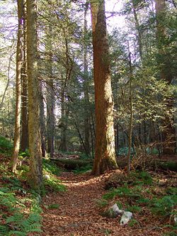
| 3 | Cook Forest Cook Forest State Park Cook Forest State Park is a Pennsylvania state park in Farmington Township, Clarion County, Barnett Township, Forest County and Barnett Township, Jefferson County, Pennsylvania in the United States. The park is a heavily wooded area of rolling hills and mountains along the Clarion River in... |
 |
Clarion Clarion, Pennsylvania Clarion is a borough in Clarion County in the U.S. state of Pennsylvania, about 100 miles north-northeast of Pittsburgh and part of the Pittsburgh DMA. Clarion was settled in 1839 and incorporated in 1841. In the past, the surrounding area produced natural gas, oil, lumber and coal. Merely 2,004... 41.323611°N 79.163889°W |
Clarion Clarion County, Pennsylvania As of the census of 2000, there were 41,765 people, 16,052 households, and 10,738 families residing in the county. The population density was 69 people per square mile . There were 19,426 housing units at an average density of 32 per square mile... , Forest Forest County, Pennsylvania Forest County is a county located in the U.S. state of Pennsylvania. As of 2010, the population is 7,716. Forest County is famous as a rural retreat. Nearly 75% of all dwellings in the county are second or vacation homes . Forest County does not have a single traffic light, the only county in the... , Jefferson Jefferson County, Pennsylvania Jefferson County is a county located in the U.S. state of Pennsylvania. In 2010, its population was 45,200. It was established on March 26, 1804, from part of Lycoming County and named for then-President Thomas Jefferson. Its county seat is Brookville... |
A 8500 acres (3,440 ha) state park notable for its spectacular stands of old-growth Eastern White Pine Eastern White Pine Pinus strobus, commonly known as the eastern white pine, is a large pine native to eastern North America, occurring from Newfoundland west to Minnesota and southeastern Manitoba, and south along the Appalachian Mountains to the northern edge of Georgia.It is occasionally known as simply white pine,... and Eastern Hemlock Eastern Hemlock Tsuga canadensis, also known as eastern or Canadian hemlock, and in the French-speaking regions of Canada as pruche du Canada, is a coniferous tree native to eastern North America. It ranges from northeastern Minnesota eastward through southern Quebec to Nova Scotia, and south in the Appalachian... , many from around 1644. |
|
| 4 | Ferncliff Peninsula Natural Area Ferncliff Peninsula Natural Area Ferncliff Peninsula Natural Area is a peninsula with a unique habitat with many rare and unusual, for Pennsylvania, plants. It is part of Ohiopyle State Park, near Ohiopyle, Pennsylvania. It was declared a National Natural Landmark in November 1973 and was named a State Park Natural Area in 1992... |
1973 | Ohiopyle Ohiopyle, Pennsylvania Ohiopyle is a borough in Fayette County, Pennsylvania, United States. The population was 77 at the 2000 census. While Ohiopyle has a tiny year-round population, it is often filled with tourists on the weekend, who come take advantage of outdoor recreation... 39.867555°N 79.498229°W |
Fayette Fayette County, Pennsylvania Fayette County is a county located in the U.S. state of Pennsylvania. As of the2010 census, the population was 136,606. The county is part of the Pittsburgh Metropolitan Statistical Area.... |
Part of Ohiopyle State Park Ohiopyle State Park Ohiopyle State Park is a Pennsylvania state park on in Dunbar, Henry Clay and Stewart Townships, Fayette County, Pennsylvania in the United States. The focal point of the park is the more than of the Youghiogheny River Gorge that passes through the park. The river provides some of the best... , this peninsula is formed by a meander Meander A meander in general is a bend in a sinuous watercourse. A meander is formed when the moving water in a stream erodes the outer banks and widens its valley. A stream of any volume may assume a meandering course, alternately eroding sediments from the outside of a bend and depositing them on the... in the Youghiogheny River Youghiogheny River The Youghiogheny River , or the Yough for short, is a tributary of the Monongahela River in the U.S. states of West Virginia, Maryland, and Pennsylvania... . It is a good example of a late successional forests in the Allegheny Mountain Allegheny Mountain Allegheny Mountain may refer to:* The Allegheny Mountains range in the eastern United States** Mountains within the range, including:***Allegheny Mountain — or "Alleghany" — demarcating much of the border between the two states... s |
|
| 6 | Florence Jones Reineman Wildlife Sanctuary | 1973 | Near Carlisle Carlisle, Pennsylvania Carlisle is a borough in and the county seat of Cumberland County, Pennsylvania, United States. The name is traditionally pronounced with emphasis on the second syllable. Carlisle is located within the Cumberland Valley, a highly productive agricultural region. As of the 2010 census, the borough... 40°16′0"N 77°16′0"W |
Cumberland Cumberland County, Pennsylvania Cumberland County is a county located in the U.S. state of Pennsylvania and is one of three counties comprising the Harrisburg–Carlisle Metropolitan Statistical Area. As of 2010, the population was 235,406.-History:... , Perry Perry County, Pennsylvania As of the census of 2000, there were 43,602 people, 16,695 households, and 12,320 families residing in the county. The population density was 79 people per square mile . There were 18,941 housing units at an average density of 34 per square mile... |
||
| 7 | Pine Creek Gorge Pine Creek Gorge Pine Creek Gorge, also known as, The Grand Canyon of Pennsylvania, is situated in approximately 160,000 acres of the Tioga State Forest in the U.S. State of Pennsylvania along Pine Creek. The Canyon begins south of Ansonia, near Wellsboro, along U.S. Route 6 and continues for approximately... |
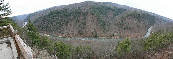 |
1968 | Situated in approximately 160,000 acres (650 km²) of the Tioga State Forest Tioga State Forest Tioga State Forest is a Pennsylvania State Forest in District #16. The main offices are located in Wellsboro in Tioga County, Pennsylvania in the United States.... , the Canyon begins south of Ansonia, near Wellsboro Wellsboro, Pennsylvania Wellsboro is a borough in Tioga County, Pennsylvania, 52 miles northwest of Williamsport. Early in the twentieth century, Wellsboro was the shipping point and trade center for a large area... , along U.S. Route 6 U.S. Route 6 U.S. Route 6 , also called the Grand Army of the Republic Highway, a name that honors an American Civil War veterans association, is a main route of the U.S. Highway system, running east-northeast from Bishop, California to Provincetown, Massachusetts. Until 1964, it continued south from Bishop to... and continues for approximately 47 miles (76 km) south. 41.271667°N 77.326944°W |
Tioga Tioga County, Pennsylvania Tioga County is a county located in the U.S. state of Pennsylvania. As of the 2010 census, the population was 41,981. Tioga County was created on March 26, 1804, from part of Lycoming County and named for the Tioga River. Its county seat is Wellsboro.... , Lycoming Lycoming County, Pennsylvania -Appalachian Mountains and Allegheny Plateau:Lycoming County is divided between the Appalachian Mountains in the south, the dissected Allegheny Plateau in the north and east, and the valley of the West Branch Susquehanna River between these.-West Branch Susquehanna River:The West Branch of the... |
Known as the "Grand Canyon of Pennsylvania", a deep gorge Canyon A canyon or gorge is a deep ravine between cliffs often carved from the landscape by a river. Rivers have a natural tendency to reach a baseline elevation, which is the same elevation as the body of water it will eventually drain into. This forms a canyon. Most canyons were formed by a process of... carved by glacial Glacier A glacier is a large persistent body of ice that forms where the accumulation of snow exceeds its ablation over many years, often centuries. At least 0.1 km² in area and 50 m thick, but often much larger, a glacier slowly deforms and flows due to stresses induced by its weight... meltwater Meltwater Meltwater is the water released by the melting of snow or ice, including glacial ice and ice shelfs over oceans. Meltwater is often found in the ablation zone of glaciers, where the rate of snow cover is reducing... . The maximum depth of the canyon Canyon A canyon or gorge is a deep ravine between cliffs often carved from the landscape by a river. Rivers have a natural tendency to reach a baseline elevation, which is the same elevation as the body of water it will eventually drain into. This forms a canyon. Most canyons were formed by a process of... is 1,450 feet (442 m) at Waterville, near the southern end. At Leonard Harrison Leonard Harrison State Park Leonard Harrison State Park is a Pennsylvania state park in Tioga County, Pennsylvania, in the United States. It is on the east rim of the Pine Creek Gorge, also known as the Grand Canyon of Pennsylvania, which is deep and nearly across here. It also serves as headquarters for the adjoining... and Colton Point State Park Colton Point State Park Colton Point State Park is a Pennsylvania state park in Tioga County, Pennsylvania, in the United States. It is on the west side of the Pine Creek Gorge, also known as the Grand Canyon of Pennsylvania, which is deep and nearly across at this location. The park extends from the creek in the... s, the depth is more than 800 feet and from rim to rim is approximately 4,000 feet (1200 m). |
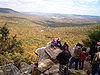
| 8 | Hawk Mountain Sanctuary Hawk Mountain Hawk Mountain is a mountain ridge, part of the Blue Mountain Ridge in the Appalachian Mountain chain, located in central-eastern Pennsylvania near Reading and Allentown. The area includes 13,000 acres of protected private and public land, including the 2,600 acre Hawk Mountain Sanctuary.The River... |
 |
1965 | 40.645556°N 75.98°W | Berks Berks County, Pennsylvania -Demographics:As of the census of 2000, there were 373,638 people, 141,570 households, and 98,532 families residing in the county. The population density was 435 people per square mile . There were 150,222 housing units at an average density of 175 per square mile... |
A privately-owned sanctuary on an Appalachian ridge, known as an excellent vantage point for hawk Hawk The term hawk can be used in several ways:* In strict usage in Australia and Africa, to mean any of the species in the subfamily Accipitrinae, which comprises the genera Accipiter, Micronisus, Melierax, Urotriorchis and Megatriorchis. The large and widespread Accipiter genus includes goshawks,... migrations. |
| 9 | Hearts Content Scenic Area Hearts Content National Scenic Area Hearts Content National Scenic Area is a tract of old-growth forest in Warren County, northwestern Pennsylvania. It represents one of the few remaining old-growth forests in the northeastern United States that contain white pine... |
1973 or 1977 | 41.691°N 79.254°W | Warren Warren County, Pennsylvania Warren County is a county located in the U.S. state of Pennsylvania. As of 2010, the population was 41,815. It was formed in 1800 from parts of Allegheny and Lycoming counties; attached to Crawford County until 1805 and then to Venango County until Warren was formally organized in 1819. Its county... |
||
| 10 | Hemlocks Natural Area | 1972 | Within Tuscarora State Forest Tuscarora State Forest Tuscarora State Forest is a Pennsylvania state forest in Pennsylvania Bureau of Forestry District #3. The main office is located in Blain in Perry County, Pennsylvania in the United States.... 40.2384178°N 77.6413785°W |
Perry Perry County, Pennsylvania As of the census of 2000, there were 43,602 people, 16,695 households, and 12,320 families residing in the county. The population density was 79 people per square mile . There were 18,941 housing units at an average density of 34 per square mile... |
||
| 11 | Hickory Run Boulder Field Hickory Run State Park Hickory Run State Park is a Pennsylvania state park in Kidder and Penn Forest Townships in Carbon County, Pennsylvania in the United States. The park is spread across the Pocono Mountains... |
1967 | Kidder and Penn Forest 41.036111°N 75.683889°W | Carbon Carbon County, Pennsylvania As of the census of 2000, there were 58,802 people, 23,701 households, and 16,424 families residing in the county. The population density was 154 people per square mile . There were 30,492 housing units at an average density of 80 per square mile... |
||
| 12 | Lake Lacawac | 1968 | Near the southwestern portion of Lake Wallenpaupack Lake Wallenpaupack Lake Wallenpaupack is a reservoir in Pennsylvania, USA. It was created in 1926 by PPL, the Pennsylvania Power & Light Company, for hydroelectric purposes. It is located near Hawley, on the border of Pike and Wayne counties in northeastern Pennsylvania... 41.382289°N 75.292078°W |
Wayne Wayne County, Pennsylvania As of the census of 2000, there were 47,722 people, 18,350 households, and 12,936 families residing in the county. The population density was 65 people per square mile . There were 30,593 housing units at an average density of 42 per square mile... |
||
| 13 | McConnells Mill State Park McConnells Mill State Park McConnells Mill State Park is a Pennsylvania state park in Perry and Slippery Rock Townships, Lawrence County, Pennsylvania in the United States. The park features a deep scenic gorge with the restored watermill and a covered bridge at the bottom, accessible by a roadway that winds between large,... |
 |
1972 | Perry Perry Township, Lawrence County, Pennsylvania Perry Township is a township in Lawrence County, Pennsylvania, United States. The population was 1,930 at the 2000 census.-Geography:According to the United States Census Bureau, the township has a total area of 18.5 square miles , of which, 18.4 square miles of it is land and... and Slippery Rock Slippery Rock Township, Lawrence County, Pennsylvania Slippery Rock Township is a township in Lawrence County, Pennsylvania, United States. The population was 3,179 at the 2000 census.-History:... Townships40.926667°N 80.19°W |
Lawrence Lawrence County, Pennsylvania Lawrence County is a county located in the U.S. state of Pennsylvania. In 2010, its population was 91,108. The county was added to the Pittsburgh Metropolitan Statistical Area in 2003. The county seat is New Castle.... |
|
| 14 | Monroe Border Fault | 1980 | Near Riegelsville Riegelsville, Pennsylvania Riegelsville is a borough in Bucks County, Pennsylvania, United States. The population was 868 at the 2010 census.-History:Benjamin Riegel founded Riegelsville. The original, and now historic, that he built in 1838 still stands. This historic stone inn has offered food and lodging to Bucks County... 40.579756°N 75.197556°W |
Bucks Bucks County, Pennsylvania - Industry and commerce :The boroughs of Bristol and Morrisville were prominent industrial centers along the Northeast Corridor during World War II. Suburban development accelerated in Lower Bucks in the 1950s with the opening of Levittown, Pennsylvania, the second such "Levittown" designed by... |
||
| 15 | Nay Aug Park Gorge and Waterfall Nay Aug Park Nay Aug Park is the largest park in Scranton, Pennsylvania, United States. An amusement park on the site closed in the 1990s, but a small amusement area still operates near the swimming pool complex... |
1989 | Scranton Scranton, Pennsylvania Scranton is a city in the northeastern part of Pennsylvania, United States. It is the county seat of Lackawanna County and the largest principal city in the Scranton/Wilkes-Barre metropolitan area. Scranton had a population of 76,089 in 2010, according to the U.S... 41.401389°N 75.642778°W |
Lackawanna Lackawanna County, Pennsylvania As of the census of 2000, there were 213,295 people, 86,218 households, and 55,783 families residing in the county. The population density was 465 people per square mile . There were 95,362 housing units at an average density of 208 per square mile... |
||
| 16 | Nottingham Park Serpentine Barrens | Nottingham Nottingham, Pennsylvania Nottingham is an unincorporated community located in West Nottingham Township, Chester County, Pennsylvania. The community is located at the intersection of U.S. 1 and Pennsylvania Route 272 near the border with East Nottingham Township a short distance north of the Maryland border. It is home to... 39.740507°N 76.039112°W |
Chester Chester County, Pennsylvania -State parks:*French Creek State Park*Marsh Creek State Park*White Clay Creek Preserve-Demographics:As of the 2010 census, the county was 85.5% White, 6.1% Black or African American, 0.2% Native American or Alaskan Native, 3.9% Asian, 0.0% Native Hawaiian, 1.8% were two or more races, and 2.4% were... |
A 651 acres (263 ha) county park on one of the largest outcrops of serpentine in the eastern US, which creates a savanna Savanna A savanna, or savannah, is a grassland ecosystem characterized by the trees being sufficiently small or widely spaced so that the canopy does not close. The open canopy allows sufficient light to reach the ground to support an unbroken herbaceous layer consisting primarily of C4 grasses.Some... -like habitat with a number of unusual flora. |
||
| 17 | Presque Isle Presque Isle State Park Presque Isle State Park is a Pennsylvania state park on an arching sandy peninsula that juts into Lake Erie, west of the city of Erie, in Millcreek Township, Erie County, Pennsylvania, in the United States. The peninsula sweeps northeastward, surrounding Presque Isle Bay along the park's... |
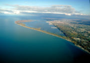 |
1967 | West of the city of Erie Erie, Pennsylvania Erie is a city located in northwestern Pennsylvania in the United States. Named for the lake and the Native American tribe that resided along its southern shore, Erie is the state's fourth-largest city , with a population of 102,000... , in Millcreek Township Millcreek Township, Erie County, Pennsylvania Millcreek Township is a township in Erie County, Pennsylvania, United States. The population was 53,515 at the 2010 census. It is the largest suburb of Erie, Pennsylvania and the sixth-largest municipality in the state; larger than the cities of Altoona and Harrisburg.Millcreek Township is home to... 42.163056°N 80.100833°W |
Erie Erie County, Pennsylvania Erie County is a county located in the U.S. state of Pennsylvania. As of 2010, the population was 280,566. Its county seat is the City of Erie.- Geography :... |
|
| 18 | Reynolds Spring and Algerine Swamp Bogs | 1974 | Primarily within Tioga State Forest Tioga State Forest Tioga State Forest is a Pennsylvania State Forest in District #16. The main offices are located in Wellsboro in Tioga County, Pennsylvania in the United States.... 41.5509021°N 77.4974807°W |
Tioga Tioga County, Pennsylvania Tioga County is a county located in the U.S. state of Pennsylvania. As of the 2010 census, the population was 41,981. Tioga County was created on March 26, 1804, from part of Lycoming County and named for the Tioga River. Its county seat is Wellsboro.... , Lycoming Lycoming County, Pennsylvania -Appalachian Mountains and Allegheny Plateau:Lycoming County is divided between the Appalachian Mountains in the south, the dissected Allegheny Plateau in the north and east, and the valley of the West Branch Susquehanna River between these.-West Branch Susquehanna River:The West Branch of the... |
||
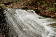
| 19 | The Glens Natural Area Ricketts Glen State Park Ricketts Glen State Park is a Pennsylvania state park on in Columbia, Luzerne, and Sullivan counties in Pennsylvania in the United States. Ricketts Glen is a National Natural Landmark known for its old-growth forest and 24 named waterfalls along Kitchen Creek, which flows down the Allegheny... |
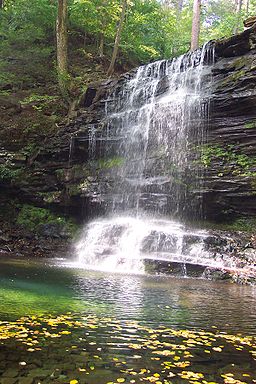 |
1968 | Sugarloaf Sugarloaf Township, Columbia County, Pennsylvania Sugarloaf Township is a township in Columbia County, Pennsylvania, United States. The population was 885 at the 2000 census.-Geography:According to the United States Census Bureau, the township has a total area of 25.9 square miles , of which, 25.9 square miles of it is land and... , Fairmount, Ross Ross Township, Luzerne County, Pennsylvania Ross Township is a township in Luzerne County, Pennsylvania, United States. The population was 2,742 at the 2000 census.-Geography:According to the United States Census Bureau, the township has a total area of 43.7 square miles , of which, 43.2 square miles of it is land and... , Colley, and Davidson 41°19′34"N 76°16′46"W |
Columbia Columbia County, Pennsylvania As of the census of 2000, there were 64,151 people, 24,915 households, and 16,568 families residing in the county. The population density was 132 people per square mile . There were 27,733 housing units at an average density of 57 per square mile... , Sullivan Sullivan County, Pennsylvania Sullivan County is a county located in the U.S. state of Pennsylvania. As of 2010, the population is 6,428. Sullivan County was created on March 15, 1847, from part of Lycoming County and named for Charles Sullivan, leader of the Pennsylvania Senate... , Luzerne Luzerne County, Pennsylvania - Demographics :As of the 2010 census, the county was 90.7% White, 3.4% Black or African American, 0.2% Native American, 1.0% Asian, 3.3% were of some other race, and 1.5% were two or more races. 6.7% of the population was of Hispanic or Latino ancestry... |
|
| 20 | Snyder Middleswarth Natural Area Snyder Middleswarth Natural Area Snyder Middleswarth Natural Area is a 500 acre National Natural Landmark within Bald Eagle State Forest in Spring Township, Snyder County, Pennsylvania in the United States. It is named for two Pennsylvania politicians from Snyder County: Simon Snyder and Ner Alexander Middleswarth... |
 |
1967 | Within Bald Eagle State Forest Bald Eagle State Forest Bald Eagle State Forest is a Pennsylvania state forest in Pennsylvania Bureau of Forestry District #7. The main office is located in Laurelton in Union County, Pennsylvania, in the United States. The forest is found in Centre, Clinton, Mifflin, Snyder, and Union Counties... in Spring Township Spring Township, Snyder County, Pennsylvania Spring Township is a township in Snyder County, Pennsylvania, United States. The population was 1,563 at the 2000 census.-Geography:According to the United States Census Bureau, the township has a total area of 37.0 square miles , of which, 37.0 square miles of it is land and... 40.81°N 77.283056°W |
Snyder Snyder County, Pennsylvania Snyder County is a county located in the U.S. state of Pennsylvania. As of 2010, the population was 39,702. Snyder County was formed in 1855 from parts of Union County... |
|
| 21 | Susquehanna Water Gaps | 1968 | About four miles south of Liverpool Liverpool, Pennsylvania Liverpool is a borough in Perry County, Pennsylvania, United States, about from Harrisburg. It is part of the Harrisburg–Carlisle Metropolitan Statistical Area... ; about a mile south of Millersburg Millersburg, Pennsylvania Millersburg is a borough in Dauphin County, Pennsylvania, United States. The population was 2,562 at the 2000 census. It is part of the Harrisburg–Carlisle Metropolitan Statistical Area.-Geography:... ; south to Harrisburg40.5209177°N 76.9788665°W |
Cumberland Cumberland County, Pennsylvania Cumberland County is a county located in the U.S. state of Pennsylvania and is one of three counties comprising the Harrisburg–Carlisle Metropolitan Statistical Area. As of 2010, the population was 235,406.-History:... , Dauphin Dauphin County, Pennsylvania Dauphin County is a county in the U.S. state of Pennsylvania and is one of the three counties comprising the Harrisburg–Carlisle Metropolitan Statistical Area. As of 2010 census, the population was 268,100. The county includes the city of Harrisburg, which has served as the state capital... , Perry Perry County, Pennsylvania As of the census of 2000, there were 43,602 people, 16,695 households, and 12,320 families residing in the county. The population density was 79 people per square mile . There were 18,941 housing units at an average density of 34 per square mile... |
Millions of years of erosive rock create impressive landforms of unique geologic heritage and outstanding natural beauty, as the Susquehanna River Susquehanna River The Susquehanna River is a river located in the northeastern United States. At long, it is the longest river on the American east coast that drains into the Atlantic Ocean, and with its watershed it is the 16th largest river in the United States, and the longest river in the continental United... cuts through five ridges of the Appalachian Mountains Appalachian Mountains The Appalachian Mountains #Whether the stressed vowel is or ,#Whether the "ch" is pronounced as a fricative or an affricate , and#Whether the final vowel is the monophthong or the diphthong .), often called the Appalachians, are a system of mountains in eastern North America. The Appalachians... north of Harrisburg. |
|
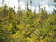
| 22 | Tamarack Swamp | 1973 | About seven miles north of Renovo Renovo, Pennsylvania Renovo is a borough in Clinton County, Pennsylvania, northwest of Lock Haven. Deposits of bituminous coal and fire clay are in the region. In 1900, 4,082 people lived there, and in 1910, 4,621 lived there... 41.4234°N 77.83944°W |
Clinton Clinton County, Pennsylvania As of the census of 2000, there were 37,914 people, 14,773 households, and 9,927 families residing in the county. The population density was 43 people per square mile . There were 18,166 housing units at an average density of 20 per square mile... |
||
| 23 | Tannersville Cranberry Bog Tannersville Cranberry Bog The Tannersville Cranberry Bog or Cranberry Swamp, is a sphagnum bog on the Cranberry Creek in Tannersville, Pennsylvania. It is the southernmost boreal bog east of the Mississippi River, containing many black spruce and tamarack trees at the southern limit of their ranges. Technically, it can be... |
 |
1974 | Tannersville Tannersville, Pennsylvania The village of Tannersville, in Pocono Township, Pennsylvania, is the site of the popular Camelback Water Beach & Ski Area. It is in the Eastern Standard time zone. Elevation is . As of 2000, the population of Tannersville was 2,784.... 41°2′24"N 75°18′21.6"W |
Monroe Monroe County, Pennsylvania -National protected areas:* Delaware Water Gap National Recreation Area * Middle Delaware National Scenic River -Demographics:As of the census of 2010, there are 176,567 people, 49,454 households, and 36,447 families residing in the county. The population density was 228 people per square mile... |
|
| 24 | John Heinz National Wildlife Refuge at Tinicum John Heinz National Wildlife Refuge at Tinicum The John Heinz National Wildlife Refuge at Tinicum is a 1000 acre National Wildlife Refuge spanning Philadelphia and Delaware counties in Pennsylvania. Located in Tinicum Township, the refuge is adjacent to the Philadelphia International Airport. Established in 1972 as the Tinicum National... |
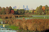 |
1965 | Located in Tinicum Township Tinicum Township, Delaware County, Pennsylvania Tinicum Township, more popularly known as "Tinicum Island" or "The Island", a census-designated place and township in Delaware County, Pennsylvania, United States. The population was 4,353 at the 2000 census. Included within the township's boundaries are the communities of Essington and Lester... , the refuge is adjacent to the Philadelphia International Airport Philadelphia International Airport Philadelphia International Airport is a major airport in Philadelphia, Pennsylvania, United States, and is the largest airport in the Delaware Valley region and in Pennsylvania... 39.885866°N 75.262356°W |
Philadelphia Philadelphia County, Pennsylvania -History:Tribes of Lenape were the first known occupants in the area which became Philadelphia County. The first European settlers were Swedes and Finns who arrived in 1638. The Netherlands seized the area in 1655, but permanently lost control to England in 1674... , Delaware Delaware County, Pennsylvania Delaware County is a county located in the U.S. state of Pennsylvania. As of 2010, the population was 558,979, making it Pennsylvania's fifth most populous county, behind Philadelphia, Allegheny, Montgomery, and Bucks counties.... |
|
| 25 | Tionesta Scenic and Research Natural Areas Tionesta Scenic and Research Natural Areas The Tionesta Scenic and Research Natural Areas are adjacent protected areas in the Allegheny National Forest of northwestern Pennsylvania. They cover a combined of the Allegheny Plateau and contain some of old-growth forest representative of the area... |
1973 | Located approximately seven miles west of Kane Kane, Pennsylvania Kane is a borough in McKean County, Pennsylvania, east by south of Erie. It was founded in 1863 by Civil War general Thomas L. Kane at an elevated site 2210 feet above sea level. In the early part of the twentieth century, Kane had large glassworks, bottle works, lumber mills, and manufactures of... 41.645°N 78.941°W |
Warren Warren County, Pennsylvania Warren County is a county located in the U.S. state of Pennsylvania. As of 2010, the population was 41,815. It was formed in 1800 from parts of Allegheny and Lycoming counties; attached to Crawford County until 1805 and then to Venango County until Warren was formally organized in 1819. Its county... , McKean McKean County, Pennsylvania As of the census of 2000, there were 45,936 people, 18,024 households, and 12,094 families residing in the county. The population density was 47 people per square mile . There were 21,644 housing units at an average density of 22 per square mile... |
||
| 26 | Titus and Wattsburg Bogs | 1977 | Approximately four miles to the southeast of Wattsburg Wattsburg, Pennsylvania Wattsburg is a borough in Erie County, Pennsylvania, United States. The population was 378 at the 2000 census. It is part of the Erie Metropolitan Statistical Area.Wattsburg is along the banks of French Creek .... 41.9433882°N 79.7631068°W |
Erie Erie County, Pennsylvania Erie County is a county located in the U.S. state of Pennsylvania. As of 2010, the population was 280,566. Its county seat is the City of Erie.- Geography :... |
||
| 27 | Wissahickon Valley |  |
1964 | Located within Fairmount Park Fairmount Park Fairmount Park is the municipal park system of Philadelphia, Pennsylvania. It consists of 63 parks, with , all overseen by the Philadelphia Department of Parks and Recreation, successor to the Fairmount Park Commission in 2010.-Fairmount Park proper:... 40.016056°N 75.205744°W |
Montgomery Montgomery County, Pennsylvania Montgomery County is a county located in the U.S. state of Pennsylvania, in the United States. As of 2010, the population was 799,874, making it the third most populous county in Pennsylvania . The county seat is Norristown.The county was created on September 10, 1784, out of land originally part... , Philadelphia Philadelphia County, Pennsylvania -History:Tribes of Lenape were the first known occupants in the area which became Philadelphia County. The first European settlers were Swedes and Finns who arrived in 1638. The Netherlands seized the area in 1655, but permanently lost control to England in 1674... |
Tributary of the Schuylkill River Schuylkill River The Schuylkill River is a river in Pennsylvania. It is a designated Pennsylvania Scenic River.The river is about long. Its watershed of about lies entirely within the state of Pennsylvania. The source of its eastern branch is in the Appalachian Mountains at Tuscarora Springs, near Tamaqua in... which it joins in Fairmount Park Fairmount Park Fairmount Park is the municipal park system of Philadelphia, Pennsylvania. It consists of 63 parks, with , all overseen by the Philadelphia Department of Parks and Recreation, successor to the Fairmount Park Commission in 2010.-Fairmount Park proper:... , Philadelphia, near Germantown. Runs through Fort Washington State Park Fort Washington State Park Fort Washington State Park is a Pennsylvania state park in Springfield and Whitemarsh Townships, Montgomery County, Pennsylvania in the United States. The park is noted for the springtime flowering of dogwood trees, and is popular with families for picnics and hiking... |