
Slippery Rock Township, Lawrence County, Pennsylvania
Encyclopedia
Slippery Rock Township is a township
in Lawrence County
, Pennsylvania
, United States
. The population was 3,179 at the 2000 census
.
, Ellwood
and Pittsburgh in 1908 by the Pittsburgh, Harmony, Butler and New Castle Railway
, an interurban
trolley line. The line closed on 15 June 1931 and the trolleys were replaced by buses.
, the township has a total area of 30.2 mi2, of which, 30.1 mi2 of it is land and 0.1 mi2 of it (0.26%) is water.
Located within Slippery Rock Township is McConnells Mill State Park
along the Slippery Rock Creek
Gorge.
of 2000, there were 3,179 people, 1,203 households, and 916 families residing in the township. The population density
was 105.5 people per square mile (40.7/km²). There were 1,285 housing units at an average density of 42.7/sq mi (16.5/km²). The racial makeup of the township was 99.18% White, 0.06% African American, 0.19% Native American, 0.13% Asian, 0.13% from other races
, and 0.31% from two or more races. Hispanic or Latino of any race were 0.38% of the population.
There were 1,203 households out of which 34.2% had children under the age of 18 living with them, 66.6% were married couples
living together, 6.7% had a female householder with no husband present, and 23.8% were non-families. 20.5% of all households were made up of individuals and 9.4% had someone living alone who was 65 years of age or older. The average household size was 2.64 and the average family size was 3.06.
In the township the population was spread out with 25.2% under the age of 18, 7.1% from 18 to 24, 27.8% from 25 to 44, 26.5% from 45 to 64, and 13.4% who were 65 years of age or older. The median age was 39 years. For every 100 females there were 98.7 males. For every 100 females age 18 and over, there were 99.7 males.
The median income for a household in the township was $38,651, and the median income for a family was $43,382. Males had a median income of $35,192 versus $21,458 for females. The per capita income
for the township was $16,160. About 4.5% of families and 5.8% of the population were below the poverty line, including 5.2% of those under age 18 and 9.4% of those age 65 or over.
Township (Pennsylvania)
A township in the Commonwealth of Pennsylvania, a state of the United States of America, is one of four types of municipalities in the state . Townships were established based on convenient geographical boundaries and vary in size from six to forty square miles...
in Lawrence County
Lawrence County, Pennsylvania
Lawrence County is a county located in the U.S. state of Pennsylvania. In 2010, its population was 91,108. The county was added to the Pittsburgh Metropolitan Statistical Area in 2003. The county seat is New Castle....
, Pennsylvania
Pennsylvania
The Commonwealth of Pennsylvania is a U.S. state that is located in the Northeastern and Mid-Atlantic regions of the United States. The state borders Delaware and Maryland to the south, West Virginia to the southwest, Ohio to the west, New York and Ontario, Canada, to the north, and New Jersey to...
, United States
United States
The United States of America is a federal constitutional republic comprising fifty states and a federal district...
. The population was 3,179 at the 2000 census
United States Census, 2000
The Twenty-second United States Census, known as Census 2000 and conducted by the Census Bureau, determined the resident population of the United States on April 1, 2000, to be 281,421,906, an increase of 13.2% over the 248,709,873 persons enumerated during the 1990 Census...
.
History
The township was linked to New CastleNew Castle, Pennsylvania
New Castle is a city in Lawrence County, Pennsylvania, United States, northwest of Pittsburgh and near the Pennsylvania-Ohio border just east of Youngstown, Ohio; in 1910, the total population was 36,280; in 1920, 44,938; and in 1940, 47,638. The population has fallen to 26,309 according to the...
, Ellwood
Ellwood City, Pennsylvania
Ellwood City is a borough in Beaver and Lawrence counties in the U.S. state of Pennsylvania. Ellwood City is 30 miles northwest of Pittsburgh and some 8 miles south by southeast of New Castle...
and Pittsburgh in 1908 by the Pittsburgh, Harmony, Butler and New Castle Railway
Pittsburgh, Harmony, Butler and New Castle Railway
The Pittsburgh, Harmony, Butler and New Castle Railway, commonly called the Harmony Line, was a broad gauge interurban streetcar line connecting Pittsburgh, Pennsylvania, United States to Butler and New Castle via Harmony and a split at Evans City...
, an interurban
Interurban
An interurban, also called a radial railway in parts of Canada, is a type of electric passenger railroad; in short a hybrid between tram and train. Interurbans enjoyed widespread popularity in the first three decades of the twentieth century in North America. Until the early 1920s, most roads were...
trolley line. The line closed on 15 June 1931 and the trolleys were replaced by buses.
Geography
According to the United States Census BureauUnited States Census Bureau
The United States Census Bureau is the government agency that is responsible for the United States Census. It also gathers other national demographic and economic data...
, the township has a total area of 30.2 mi2, of which, 30.1 mi2 of it is land and 0.1 mi2 of it (0.26%) is water.
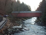
Located within Slippery Rock Township is McConnells Mill State Park
McConnells Mill State Park
McConnells Mill State Park is a Pennsylvania state park in Perry and Slippery Rock Townships, Lawrence County, Pennsylvania in the United States. The park features a deep scenic gorge with the restored watermill and a covered bridge at the bottom, accessible by a roadway that winds between large,...
along the Slippery Rock Creek
Slippery Rock Creek
Slippery Rock Creek is a small stream in Western Pennsylvania, a tributary of Connoquenessing Creek. From its source in Hilliards in Butler County, it flows through McConnells Mill State Park before flowing into the Connoquenessing in Ellwood City. Then, the Connoquenessing flows into the Beaver...
Gorge.
Demographics
As of the censusCensus
A census is the procedure of systematically acquiring and recording information about the members of a given population. It is a regularly occurring and official count of a particular population. The term is used mostly in connection with national population and housing censuses; other common...
of 2000, there were 3,179 people, 1,203 households, and 916 families residing in the township. The population density
Population density
Population density is a measurement of population per unit area or unit volume. It is frequently applied to living organisms, and particularly to humans...
was 105.5 people per square mile (40.7/km²). There were 1,285 housing units at an average density of 42.7/sq mi (16.5/km²). The racial makeup of the township was 99.18% White, 0.06% African American, 0.19% Native American, 0.13% Asian, 0.13% from other races
Race (United States Census)
Race and ethnicity in the United States Census, as defined by the Federal Office of Management and Budget and the United States Census Bureau, are self-identification data items in which residents choose the race or races with which they most closely identify, and indicate whether or not they are...
, and 0.31% from two or more races. Hispanic or Latino of any race were 0.38% of the population.
There were 1,203 households out of which 34.2% had children under the age of 18 living with them, 66.6% were married couples
Marriage
Marriage is a social union or legal contract between people that creates kinship. It is an institution in which interpersonal relationships, usually intimate and sexual, are acknowledged in a variety of ways, depending on the culture or subculture in which it is found...
living together, 6.7% had a female householder with no husband present, and 23.8% were non-families. 20.5% of all households were made up of individuals and 9.4% had someone living alone who was 65 years of age or older. The average household size was 2.64 and the average family size was 3.06.
In the township the population was spread out with 25.2% under the age of 18, 7.1% from 18 to 24, 27.8% from 25 to 44, 26.5% from 45 to 64, and 13.4% who were 65 years of age or older. The median age was 39 years. For every 100 females there were 98.7 males. For every 100 females age 18 and over, there were 99.7 males.
The median income for a household in the township was $38,651, and the median income for a family was $43,382. Males had a median income of $35,192 versus $21,458 for females. The per capita income
Per capita income
Per capita income or income per person is a measure of mean income within an economic aggregate, such as a country or city. It is calculated by taking a measure of all sources of income in the aggregate and dividing it by the total population...
for the township was $16,160. About 4.5% of families and 5.8% of the population were below the poverty line, including 5.2% of those under age 18 and 9.4% of those age 65 or over.