
McConnells Mill State Park
Encyclopedia
McConnells Mill State Park is a 2546 acres (1,030.3 ha) Pennsylvania state park in Perry
and Slippery Rock Township
s, Lawrence County, Pennsylvania
in the United States. The park features a deep scenic gorge with the restored watermill
and a covered bridge
at the bottom, accessible by a roadway that winds between large, room-sized boulder
s on the hillside. McConnells Mill State Park is along the Slippery Rock Creek
just southwest of the intersection of US 422 and US 19.
McConnells Mill State Park was chosen by the Pennsylvania Department of Conservation and Natural Resources
(DCNR) and its Bureau of Parks as one of "Twenty Must-See Pennsylvania State Parks".
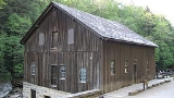
on Slippery Rock Creek in 1852. The mill was destroyed by fire in 1868 and was quickly rebuilt. Ownership of the mill was transferred to the park's namesake, Thomas McConnell in 1875. He replaced the waterwheel with water turbines and the grindstone
s with rolling mills. This made McConnell's Mill one of the first rolling mills in the country. The mill processed oats
, corn
, buckwheat
and wheat
until it was closed in 1928. Ownership of the land transferred from Thomas H. Hartman to the Western Pennsylvania Conservancy
in 1942. The conservancy then transferred the land to the Commonwealth of Pennsylvania in 1957 when McConnells Mill State Park was formally dedicated.
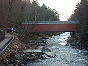
The McConnell's Mill Covered Bridge
was built in 1874. It is a Howe truss bridge. One of two covered bridges in Lawrence County, it is owned by the county, but is located on state land at McConnells Mill State Park. The bridge is listed in the National Register of Historic Places
.
s in the park, including a pair that lead to a waterfall
(with an old limestone
kiln
next to it). A recent addition to the trail system is North Country Trail
. There are two Climbing
/Rappelling areas. Both are only recommended for "equipped and experienced climbers". The more difficult of the two is at Breakneck Bridge.
boating is very popular on this part of Slippery Rock Creek
and it is rated a Class II-III, on the International Scale of River Difficulty
, depending on water conditions. Boating usually begins at the U.S. Route 422 bridge at Rose Point, outside the park boundary and passes under Eckert Bridge within the park before ending at Harris Bridge. There is a portage at the dam at the Old Mill. It is illegal to "run" the dam. All boaters are required to wear life jackets that are approved by the United States Coast Guard
.
 Hunting is permitted in much of McConnells Mill State Park. Hunters are expected to follow the rules and regulations of the Pennsylvania Game Commission
. The common game species are ruffed grouse
, squirrels
, turkey
, white-tailed deer
, and rabbits
. The hunting of groundhog
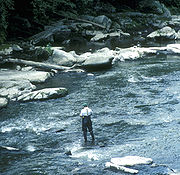
s is not permitted at the park. The Pennsylvania Fish and Boat Commission
assures that anglers will have plenty of chances to catch fish by stocking
trout
and bass
in the waters of Slippery Rock Creek.
, mud and sand were compressed. This part of Pennsylvania was a coastal area at the time. The layers of bedrock were built into mountains as the continental plates shifted. The layers of bedrock had different strengths. Some of the layers eroded quickly and others eroded at a much slower pace. The various erosion rates account of the variety of geologic features at McConnells Mill State Park. The geology of the park was also heavily influenced by the glacial effects of the ice age
: a large glacial lake
(water that was held in place by a glacier), broke about 140,000 years ago. This break in the glacial dam caused a dramatic change in the flow of the water. The lake that had previously drained in a northward direction was now draining to the south. The drastic change in direction and very high volume of water flow created Slippery Rock Creek Gorge.
ecoregion
.
Perry Township, Lawrence County, Pennsylvania
Perry Township is a township in Lawrence County, Pennsylvania, United States. The population was 1,930 at the 2000 census.-Geography:According to the United States Census Bureau, the township has a total area of 18.5 square miles , of which, 18.4 square miles of it is land and...
and Slippery Rock Township
Slippery Rock Township, Lawrence County, Pennsylvania
Slippery Rock Township is a township in Lawrence County, Pennsylvania, United States. The population was 3,179 at the 2000 census.-History:...
s, Lawrence County, Pennsylvania
Pennsylvania
The Commonwealth of Pennsylvania is a U.S. state that is located in the Northeastern and Mid-Atlantic regions of the United States. The state borders Delaware and Maryland to the south, West Virginia to the southwest, Ohio to the west, New York and Ontario, Canada, to the north, and New Jersey to...
in the United States. The park features a deep scenic gorge with the restored watermill
Watermill
A watermill is a structure that uses a water wheel or turbine to drive a mechanical process such as flour, lumber or textile production, or metal shaping .- History :...
and a covered bridge
Covered bridge
A covered bridge is a bridge with enclosed sides and a roof, often accommodating only a single lane of traffic. Most covered bridges are wooden; some newer ones are concrete or metal with glass sides...
at the bottom, accessible by a roadway that winds between large, room-sized boulder
Boulder
In geology, a boulder is a rock with grain size of usually no less than 256 mm diameter. While a boulder may be small enough to move or roll manually, others are extremely massive....
s on the hillside. McConnells Mill State Park is along the Slippery Rock Creek
Slippery Rock Creek
Slippery Rock Creek is a small stream in Western Pennsylvania, a tributary of Connoquenessing Creek. From its source in Hilliards in Butler County, it flows through McConnells Mill State Park before flowing into the Connoquenessing in Ellwood City. Then, the Connoquenessing flows into the Beaver...
just southwest of the intersection of US 422 and US 19.
McConnells Mill State Park was chosen by the Pennsylvania Department of Conservation and Natural Resources
Pennsylvania Department of Conservation and Natural Resources
The Pennsylvania Department of Conservation and Natural Resources , established on July 1, 1995, is the agency in the U.S. State of Pennsylvania responsible for maintaining and preserving the state's 117 state parks and 20 state forests; providing information on the state's natural resources; and...
(DCNR) and its Bureau of Parks as one of "Twenty Must-See Pennsylvania State Parks".
McConnell's Mill
Daniel Kennedy opened a gristmillGristmill
The terms gristmill or grist mill can refer either to a building in which grain is ground into flour, or to the grinding mechanism itself.- Early history :...
on Slippery Rock Creek in 1852. The mill was destroyed by fire in 1868 and was quickly rebuilt. Ownership of the mill was transferred to the park's namesake, Thomas McConnell in 1875. He replaced the waterwheel with water turbines and the grindstone
Millstone
Millstones or mill stones are used in windmills and watermills, including tide mills, for grinding wheat or other grains.The type of stone most suitable for making millstones is a siliceous rock called burrstone , an open-textured, porous but tough, fine-grained sandstone, or a silicified,...
s with rolling mills. This made McConnell's Mill one of the first rolling mills in the country. The mill processed oats
OATS
OATS - Open Source Assistive Technology Software - is a source code repository or "forge" for assistive technology software. It was launched in 2006 with the goal to provide a one-stop “shop” for end users, clinicians and open-source developers to promote and develop open source assistive...
, corn
Maize
Maize known in many English-speaking countries as corn or mielie/mealie, is a grain domesticated by indigenous peoples in Mesoamerica in prehistoric times. The leafy stalk produces ears which contain seeds called kernels. Though technically a grain, maize kernels are used in cooking as a vegetable...
, buckwheat
Buckwheat
Buckwheat refers to a variety of plants in the dicot family Polygonaceae: the Eurasian genus Fagopyrum, the North American genus Eriogonum, and the Northern Hemisphere genus Fallopia. Either of the latter two may be referred to as "wild buckwheat"...
and wheat
Wheat
Wheat is a cereal grain, originally from the Levant region of the Near East, but now cultivated worldwide. In 2007 world production of wheat was 607 million tons, making it the third most-produced cereal after maize and rice...
until it was closed in 1928. Ownership of the land transferred from Thomas H. Hartman to the Western Pennsylvania Conservancy
Western Pennsylvania Conservancy
The Western Pennsylvania Conservancy , headquartered in Pittsburgh, has been around for more than 75 years and exists to protect the water, land and life of western Pennsylvania. Half of all the land that has been protected by land trusts in Pennsylvania has been conserved by the Western...
in 1942. The conservancy then transferred the land to the Commonwealth of Pennsylvania in 1957 when McConnells Mill State Park was formally dedicated.
Covered bridge
The McConnell's Mill Covered Bridge
McConnell's Mill Covered Bridge
The McConnell's Mill Covered Bridge is a wooden covered bridge in Slippery Rock Township, Lawrence County, Pennsylvania, United States. It spans the Slippery Rock Creek in McConnells Mill State Park, southeast of Rose Point, Built in 1874, the bridge is a Howe truss built on stone foundations and...
was built in 1874. It is a Howe truss bridge. One of two covered bridges in Lawrence County, it is owned by the county, but is located on state land at McConnells Mill State Park. The bridge is listed in the National Register of Historic Places
National Register of Historic Places
The National Register of Historic Places is the United States government's official list of districts, sites, buildings, structures, and objects deemed worthy of preservation...
.
Hiking and rock climbing
There are several trailTrail
A trail is a path with a rough beaten or dirt/stone surface used for travel. Trails may be for use only by walkers and in some places are the main access route to remote settlements...
s in the park, including a pair that lead to a waterfall
Waterfall
A waterfall is a place where flowing water rapidly drops in elevation as it flows over a steep region or a cliff.-Formation:Waterfalls are commonly formed when a river is young. At these times the channel is often narrow and deep. When the river courses over resistant bedrock, erosion happens...
(with an old limestone
Limestone
Limestone is a sedimentary rock composed largely of the minerals calcite and aragonite, which are different crystal forms of calcium carbonate . Many limestones are composed from skeletal fragments of marine organisms such as coral or foraminifera....
kiln
Kiln
A kiln is a thermally insulated chamber, or oven, in which a controlled temperature regime is produced. Uses include the hardening, burning or drying of materials...
next to it). A recent addition to the trail system is North Country Trail
North Country Trail
The North Country National Scenic Trail , which stretches approximately from Crown Point in eastern New York to Lake Sakakawea in central North Dakota in the United States, is the longest of the eleven National Scenic Trails authorized by Congress...
. There are two Climbing
Climbing
Climbing is the activity of using one's hands and feet to ascend a steep object. It is done both for recreation and professionally, as part of activities such as maintenance of a structure, or military operations.Climbing activities include:* Bouldering: Ascending boulders or small...
/Rappelling areas. Both are only recommended for "equipped and experienced climbers". The more difficult of the two is at Breakneck Bridge.
- Alpha Pass Trail is a "moderate" 1.5 miles (2.4 km) hiking trail that is marked with blue blazes. The trail is part of the North Country TrailNorth Country TrailThe North Country National Scenic Trail , which stretches approximately from Crown Point in eastern New York to Lake Sakakawea in central North Dakota in the United States, is the longest of the eleven National Scenic Trails authorized by Congress...
. The section in the park begins at the Alpha Pass scenic view. It then runs along the east bank of Slippery Rock Creek to the Old Mill.
- Hells Hollow Trail is an "easy" 0.5 mile (0.80467 km) hiking trail that begins at the Hells Hollow parking area and follows Hell Run to the restored lime kiln and on to Hells Hollow Falls.
- Kildoo Trail is a "moderate" 2 miles (3.2 km) hiking trail loop. It begins and ends at the McConnells Mill Covered Bridge and follows the banks of Slippery Rock Creek. The western portion of the trail is marked with blue blazes and is also part of the North Country Trail.
- Slippery Rock Gorge Trail is a "moderate" to "difficult" trail that is part of the North Country TrailNorth Country TrailThe North Country National Scenic Trail , which stretches approximately from Crown Point in eastern New York to Lake Sakakawea in central North Dakota in the United States, is the longest of the eleven National Scenic Trails authorized by Congress...
in some places and is marked with blue blazes. The trail passes through several different geological areas. The first portion of the trail is in the upper end of Hell Run Valley. The trail then descends into Slippery Rock Gorge and onto an alluvial flood plain at the bottom of the gorge. From the flood plain, the trail ascends the gorge and descends once again before following the main creek bank to its terminus at Eckert Bridge.
Whitewater Boating
WhitewaterWhitewater
Whitewater is formed in a rapid, when a river's gradient increases enough to disturb its laminar flow and create turbulence, i.e. form a bubbly, or aerated and unstable current; the frothy water appears white...
boating is very popular on this part of Slippery Rock Creek
Slippery Rock Creek
Slippery Rock Creek is a small stream in Western Pennsylvania, a tributary of Connoquenessing Creek. From its source in Hilliards in Butler County, it flows through McConnells Mill State Park before flowing into the Connoquenessing in Ellwood City. Then, the Connoquenessing flows into the Beaver...
and it is rated a Class II-III, on the International Scale of River Difficulty
International Scale of River Difficulty
The International Scale of River Difficulty is a standardized scale used to rate the safety of a stretch of river, or a single rapid. The grade reflects the technical difficulty and skill level required associated with the section of river...
, depending on water conditions. Boating usually begins at the U.S. Route 422 bridge at Rose Point, outside the park boundary and passes under Eckert Bridge within the park before ending at Harris Bridge. There is a portage at the dam at the Old Mill. It is illegal to "run" the dam. All boaters are required to wear life jackets that are approved by the United States Coast Guard
United States Coast Guard
The United States Coast Guard is a branch of the United States Armed Forces and one of the seven U.S. uniformed services. The Coast Guard is a maritime, military, multi-mission service unique among the military branches for having a maritime law enforcement mission and a federal regulatory agency...
.
Hunting and fishing
Pennsylvania Game Commission
The Pennsylvania Game Commission is the state agency responsible for wildlife conservation and management in Pennsylvania in the United States...
. The common game species are ruffed grouse
Ruffed Grouse
The Ruffed Grouse is a medium-sized grouse occurring in forests from the Appalachian Mountains across Canada to Alaska. It is non-migratory.The Ruffed Grouse is frequently referred to as a "partridge"...
, squirrels
Eastern Gray Squirrel
The eastern gray squirrel is a tree squirrel in the genus Sciurus native to the eastern and midwestern United States, and to the southerly portions of the eastern provinces of Canada...
, turkey
Wild Turkey
The Wild Turkey is native to North America and is the heaviest member of the Galliformes. It is the same species as the domestic turkey, which derives from the South Mexican subspecies of wild turkey .Adult wild turkeys have long reddish-yellow to grayish-green...
, white-tailed deer
White-tailed Deer
The white-tailed deer , also known as the Virginia deer or simply as the whitetail, is a medium-sized deer native to the United States , Canada, Mexico, Central America, and South America as far south as Peru...
, and rabbits
Eastern Cottontail
The eastern cottontail is a New World cottontail rabbit, a member of the family Leporidae. It is one of the most common rabbit species in North America.-Distribution:...
. The hunting of groundhog
Groundhog
The groundhog , also known as a woodchuck, whistle-pig, or in some areas as a land-beaver, is a rodent of the family Sciuridae, belonging to the group of large ground squirrels known as marmots. Other marmots, such as the yellow-bellied and hoary marmots, live in rocky and mountainous areas, but...
s is not permitted at the park. The Pennsylvania Fish and Boat Commission
Pennsylvania Fish and Boat Commission
The Pennsylvania Fish and Boat Commission is the state agency responsible for the regulation of all fishing and boating in the Commonwealth of Pennsylvania...
assures that anglers will have plenty of chances to catch fish by stocking
Fish stocking
Fish stocking is the practice of raising fish in a hatchery and releasing them into a river, lake, or the ocean to supplement existing populations, or to create a population where none exists...
trout
Trout
Trout is the name for a number of species of freshwater and saltwater fish belonging to the Salmoninae subfamily of the family Salmonidae. Salmon belong to the same family as trout. Most salmon species spend almost all their lives in salt water...
and bass
Bass (fish)
Bass is a name shared by many different species of popular gamefish. The term encompasses both freshwater and marine species. All belong to the large order Perciformes, or perch-like fishes, and in fact the word bass comes from Middle English bars, meaning "perch."-Types of basses:*The temperate...
in the waters of Slippery Rock Creek.
Geology
The bedrock at McConnells Mill State Park was formed over 300,000,000 years ago as layers of peatPeat
Peat is an accumulation of partially decayed vegetation matter or histosol. Peat forms in wetland bogs, moors, muskegs, pocosins, mires, and peat swamp forests. Peat is harvested as an important source of fuel in certain parts of the world...
, mud and sand were compressed. This part of Pennsylvania was a coastal area at the time. The layers of bedrock were built into mountains as the continental plates shifted. The layers of bedrock had different strengths. Some of the layers eroded quickly and others eroded at a much slower pace. The various erosion rates account of the variety of geologic features at McConnells Mill State Park. The geology of the park was also heavily influenced by the glacial effects of the ice age
Ice age
An ice age or, more precisely, glacial age, is a generic geological period of long-term reduction in the temperature of the Earth's surface and atmosphere, resulting in the presence or expansion of continental ice sheets, polar ice sheets and alpine glaciers...
: a large glacial lake
Glacial lake
A glacial lake is a lake with origins in a melted glacier. Near the end of the last glacial period, roughly 10,000 years ago, glaciers began to retreat. A retreating glacier often left behind large deposits of ice in hollows between drumlins or hills. As the ice age ended, these melted to create...
(water that was held in place by a glacier), broke about 140,000 years ago. This break in the glacial dam caused a dramatic change in the flow of the water. The lake that had previously drained in a northward direction was now draining to the south. The drastic change in direction and very high volume of water flow created Slippery Rock Creek Gorge.
Environment
McConnells Mill State Park lies within the Appalachian mixed mesophytic forestsAppalachian mixed mesophytic forests
The Appalachian mixed mesophytic forests are an ecoregion of mesophytic plants west of the Appalachian Mountains in the southeastern United States.-Setting:...
ecoregion
Ecoregion
An ecoregion , sometimes called a bioregion, is an ecologically and geographically defined area that is smaller than an ecozone and larger than an ecosystem. Ecoregions cover relatively large areas of land or water, and contain characteristic, geographically distinct assemblages of natural...
.
Nearby state parks
The following state parks are within 30 miles (48.3 km) of McConnells Mill State Park:- Jennings Environmental Education CenterJennings Environmental Education CenterJennings Environmental Education Center is a Pennsylvania state park in Brady Township, Butler County, Pennsylvania in the United States. It is north of Butler on Pennsylvania Route 528. The center contains a relict prairie of , the only publicly protected prairie ecosystem in Pennsylvania...
(Butler CountyButler County, Pennsylvania-Demographics:As of the census of 2000, there were 174,083 people, 65,862 households, and 46,827 families residing in the county. The population density was 221 people per square mile . There were 69,868 housing units at an average density of 89 per square mile...
) - Moraine State ParkMoraine State ParkMoraine State Park is a Pennsylvania state park on in Brady, Clay, Franklin, Muddy Creek, and Worth townships in Butler County, Pennsylvania, in the United States. The main feature of the park is its man-made lake, Lake Arthur, formed by impounding Muddy Creek, which is and is used for...
(Butler County)