
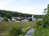
Cherry Tree, Pennsylvania
Encyclopedia
Cherry Tree is a borough in Indiana County
, Pennsylvania
, United States
. The population was 443 at the 2000 census.
where the river is fed by Cush Cushion Creek.
Cherry Tree was originally known as "Canoe Place" because its location marked the spot where the West Branch of the Susquehanna River was no longer navigable and canoes would have to portage
. The latter settlement was known as "Newman's Mills" and later "Grant Post Office". The current name was officially adopted in 1907 but had been in use informally by local residents for many years before that time.
Cherry Tree was named for a large cherry tree that stood at the confluence of Cush Cushion Creek and the West Branch of the Susquehanna River. The tree marked the eastern boundary of the territory acquired by the Penn family from the Six Nations of the Iroquois
at the Treaty of Fort Stanwix
on November 5, 1769. The boundary, called the "purchase line
", extended from the cherry tree westward to the current site of Kittanning, Pennsylvania
on the Allegheny River
. The tree was later used as a boundary marker
for Indiana
, Clearfield
, and Cambria
counties.
Cherry Tree was a center of the lumber
industry in the later 19th century.
According to the United States Census Bureau
, the borough has a total area of 0.5 square miles (1.3 km²), all of it land.
of 2000, there were 443 people, 142 households, and 111 families residing in the borough. The population density
was 833.4 people per square mile (322.7/km²). There were 157 housing units at an average density of 295.3 per square mile (114.4/km²). The racial makeup of the borough was 99.32% White and 0.68% African American. Hispanic or Latino of any race were 0.68% of the population.
There were 142 households out of which 33.1% had children under the age of 18 living with them, 64.8% were married couples
living together, 7.0% had a female householder with no husband present, and 21.8% were non-families. 16.9% of all households were made up of individuals and 9.2% had someone living alone who was 65 years of age or older. The average household size was 2.86 and the average family size was 3.24.
In the borough the population was spread out with 23.7% under the age of 18, 8.8% from 18 to 24, 28.0% from 25 to 44, 21.4% from 45 to 64, and 18.1% who were 65 years of age or older. The median age was 37 years. For every 100 females there were 100.5 males. For every 100 females age 18 and over, there were 95.4 males.
The median income for a household in the borough was $26,607, and the median income for a family was $31,625. Males had a median income of $23,667 versus $17,344 for females. The per capita income
for the borough was $11,742. About 17.8% of families and 20.3% of the population were below the poverty line, including 26.3% of those under age 18 and 24.3% of those age 65 or over.
Indiana County, Pennsylvania
-Government and politics:As of November 2008, there are 58,077 registered voters in Indiana County .* Democratic: 26,653 * Republican: 24,159 * Other Parties: 7,265 -County commissioners:*Rodney Ruddock, Chairman, Republican...
, Pennsylvania
Pennsylvania
The Commonwealth of Pennsylvania is a U.S. state that is located in the Northeastern and Mid-Atlantic regions of the United States. The state borders Delaware and Maryland to the south, West Virginia to the southwest, Ohio to the west, New York and Ontario, Canada, to the north, and New Jersey to...
, United States
United States
The United States of America is a federal constitutional republic comprising fifty states and a federal district...
. The population was 443 at the 2000 census.
History
Cherry Tree is situated mostly in a valley near the headwaters of West Branch of the Susquehanna RiverWest Branch Susquehanna River
The West Branch Susquehanna River is one of the two principal branches, along with the North Branch, of the Susquehanna River in the northeastern United States. The North Branch, which rises in upstate New York, is generally regarded as the extension of the main branch, with the shorter West Branch...
where the river is fed by Cush Cushion Creek.
Cherry Tree was originally known as "Canoe Place" because its location marked the spot where the West Branch of the Susquehanna River was no longer navigable and canoes would have to portage
Portage
Portage or portaging refers to the practice of carrying watercraft or cargo over land to avoid river obstacles, or between two bodies of water. A place where this carrying occurs is also called a portage; a person doing the carrying is called a porter.The English word portage is derived from the...
. The latter settlement was known as "Newman's Mills" and later "Grant Post Office". The current name was officially adopted in 1907 but had been in use informally by local residents for many years before that time.
Cherry Tree was named for a large cherry tree that stood at the confluence of Cush Cushion Creek and the West Branch of the Susquehanna River. The tree marked the eastern boundary of the territory acquired by the Penn family from the Six Nations of the Iroquois
Iroquois
The Iroquois , also known as the Haudenosaunee or the "People of the Longhouse", are an association of several tribes of indigenous people of North America...
at the Treaty of Fort Stanwix
Treaty of Fort Stanwix
The Treaty of Fort Stanwix was an important treaty between North American Indians and the British Empire. It was signed in 1768 at Fort Stanwix, located in present-day Rome, New York...
on November 5, 1769. The boundary, called the "purchase line
Purchase line
The Purchase Line is the name commonly given to the line dividing Indian from British Colonial lands established in the Treaty of Fort Stanwix of 1768 in western Pennsylvania...
", extended from the cherry tree westward to the current site of Kittanning, Pennsylvania
Kittanning, Pennsylvania
Kittanning is a borough and the county seat of Armstrong County, Pennsylvania in the United States. It is situated northeast of Pittsburgh, along the east bank of the Allegheny River. The name means "at the great stream" in the Delaware language...
on the Allegheny River
Allegheny River
The Allegheny River is a principal tributary of the Ohio River; it is located in the Eastern United States. The Allegheny River joins with the Monongahela River to form the Ohio River at the "Point" of Point State Park in Downtown Pittsburgh, Pennsylvania...
. The tree was later used as a boundary marker
Boundary marker
A boundary marker, boundary stone or border stone is a robust physical marker that identifies the start of a land boundary or the change in a boundary, especially a change in a direction of a boundary...
for Indiana
Indiana County, Pennsylvania
-Government and politics:As of November 2008, there are 58,077 registered voters in Indiana County .* Democratic: 26,653 * Republican: 24,159 * Other Parties: 7,265 -County commissioners:*Rodney Ruddock, Chairman, Republican...
, Clearfield
Clearfield County, Pennsylvania
Clearfield County is a county located in the U.S. state of Pennsylvania. As of 2010, the population was 81,642.Clearfield County was created on March 26, 1804, from parts of Huntingdon and Lycoming Counties but was administered as part of Centre County until 1812...
, and Cambria
Cambria County, Pennsylvania
Cambria County is a county located in the U.S. state of Pennsylvania. It comprises the Johnstown, Pennsylvania, Metropolitan Statistical Area. As of 2010, the population was 143,679....
counties.
Cherry Tree was a center of the lumber
Lumber
Lumber or timber is wood in any of its stages from felling through readiness for use as structural material for construction, or wood pulp for paper production....
industry in the later 19th century.
Geography
Cherry Tree is located at 40°43′35"N 78°48′27"W (40.726420, -78.807558) in the eastern corner of Indiana County where it intersects with Clearfield and Cambria Counties.According to the United States Census Bureau
United States Census Bureau
The United States Census Bureau is the government agency that is responsible for the United States Census. It also gathers other national demographic and economic data...
, the borough has a total area of 0.5 square miles (1.3 km²), all of it land.
Demographics
As of the censusCensus
A census is the procedure of systematically acquiring and recording information about the members of a given population. It is a regularly occurring and official count of a particular population. The term is used mostly in connection with national population and housing censuses; other common...
of 2000, there were 443 people, 142 households, and 111 families residing in the borough. The population density
Population density
Population density is a measurement of population per unit area or unit volume. It is frequently applied to living organisms, and particularly to humans...
was 833.4 people per square mile (322.7/km²). There were 157 housing units at an average density of 295.3 per square mile (114.4/km²). The racial makeup of the borough was 99.32% White and 0.68% African American. Hispanic or Latino of any race were 0.68% of the population.
There were 142 households out of which 33.1% had children under the age of 18 living with them, 64.8% were married couples
Marriage
Marriage is a social union or legal contract between people that creates kinship. It is an institution in which interpersonal relationships, usually intimate and sexual, are acknowledged in a variety of ways, depending on the culture or subculture in which it is found...
living together, 7.0% had a female householder with no husband present, and 21.8% were non-families. 16.9% of all households were made up of individuals and 9.2% had someone living alone who was 65 years of age or older. The average household size was 2.86 and the average family size was 3.24.
In the borough the population was spread out with 23.7% under the age of 18, 8.8% from 18 to 24, 28.0% from 25 to 44, 21.4% from 45 to 64, and 18.1% who were 65 years of age or older. The median age was 37 years. For every 100 females there were 100.5 males. For every 100 females age 18 and over, there were 95.4 males.
The median income for a household in the borough was $26,607, and the median income for a family was $31,625. Males had a median income of $23,667 versus $17,344 for females. The per capita income
Per capita income
Per capita income or income per person is a measure of mean income within an economic aggregate, such as a country or city. It is calculated by taking a measure of all sources of income in the aggregate and dividing it by the total population...
for the borough was $11,742. About 17.8% of families and 20.3% of the population were below the poverty line, including 26.3% of those under age 18 and 24.3% of those age 65 or over.