
Landmarks of the Nebraska Territory
Encyclopedia
Landmark
s of the Nebraska Territory
were important to settlers on the Oregon
, California
and Mormon
trail
s. While the majority of the landmarks were close to the Platte River
, others were spread across the state.
Kansas at Gage County
. They continue east/northeasterly across present-day Nebraska. The Mormon Trail
entered the Nebraska Territory at Cutler's Park
, across the Missouri River
from Kanesville, Iowa. It continued easterly along the Elkhorn
and Platte
River
s.
Landmark
This is a list of landmarks around the world.Landmarks may be split into two categories - natural phenomena and man-made features, like buildings, bridges, statues, public squares and so forth...
s of the Nebraska Territory
Nebraska Territory
The Territory of Nebraska was an organized incorporated territory of the United States that existed from May 30, 1854, until March 1, 1867, when the final extent of the territory was admitted to the Union as the State of Nebraska. The Nebraska Territory was created by the Kansas–Nebraska Act of 1854...
were important to settlers on the Oregon
Oregon Trail
The Oregon Trail is a historic east-west wagon route that connected the Missouri River to valleys in Oregon and locations in between.After 1840 steam-powered riverboats and steamboats traversing up and down the Ohio, Mississippi and Missouri rivers sped settlement and development in the flat...
, California
California Trail
The California Trail was an emigrant trail of about across the western half of the North American continent from Missouri River towns to what is now the state of California...
and Mormon
Mormon Trail
The Mormon Trail or Mormon Pioneer Trail is the 1,300 mile route that members of The Church of Jesus Christ of Latter-day Saints traveled from 1846 to 1868...
trail
Trail
A trail is a path with a rough beaten or dirt/stone surface used for travel. Trails may be for use only by walkers and in some places are the main access route to remote settlements...
s. While the majority of the landmarks were close to the Platte River
Platte River
The Platte River is a major river in the state of Nebraska and is about long. Measured to its farthest source via its tributary the North Platte River, it flows for over . The Platte River is a tributary of the Missouri River, which in turn is a tributary of the Mississippi River which flows to...
, others were spread across the state.
The trails
Landmarks in the Nebraska Territory were often related to their proximity to the several trails that crossed the area. The Oregon and California Trails entered the Territory from the Kansas TerritoryKansas Territory
The Territory of Kansas was an organized incorporated territory of the United States that existed from May 30, 1854, until January 29, 1861, when the eastern portion of the territory was admitted to the Union as the State of Kansas....
Kansas at Gage County
Gage County, Nebraska
-History:Gage County was formed with land taken from the Oto in an 1854 treaty. It was named after the minister William D. Gage.-Demographics:As of the census of 2000, there were 22,993 people, 9,316 households, and 6,204 families residing in the county. The population density was 27 people per...
. They continue east/northeasterly across present-day Nebraska. The Mormon Trail
Mormon Trail
The Mormon Trail or Mormon Pioneer Trail is the 1,300 mile route that members of The Church of Jesus Christ of Latter-day Saints traveled from 1846 to 1868...
entered the Nebraska Territory at Cutler's Park
Cutler's Park
Cutler's Park was briefly the headquarter camp of The Church of Jesus Christ of Latter-day Saints established by 2500 members as they were making their way westward to the Rocky Mountains...
, across the Missouri River
Missouri River
The Missouri River flows through the central United States, and is a tributary of the Mississippi River. It is the longest river in North America and drains the third largest area, though only the thirteenth largest by discharge. The Missouri's watershed encompasses most of the American Great...
from Kanesville, Iowa. It continued easterly along the Elkhorn
Elkhorn River
The Elkhorn River originates in the eastern Sandhills of Nebraska and is one of the largest tributaries of the Platte River, flowing and joining the Platte just southwest of Omaha, approximately 1 mile south and 3 miles west of Gretna.Located in northeast and north-central Nebraska, the Elkhorn...
and Platte
Platte River
The Platte River is a major river in the state of Nebraska and is about long. Measured to its farthest source via its tributary the North Platte River, it flows for over . The Platte River is a tributary of the Missouri River, which in turn is a tributary of the Mississippi River which flows to...
River
River
A river is a natural watercourse, usually freshwater, flowing towards an ocean, a lake, a sea, or another river. In a few cases, a river simply flows into the ground or dries up completely before reaching another body of water. Small rivers may also be called by several other names, including...
s.
Landmarks
| Landmarks of the Nebraska Territory (East-to-west order) | ||
|---|---|---|
| Name | Nearest town | Details |
| Audubon Spring Creek Prairie | Denton Denton, Nebraska Denton is a village in Lancaster County, Nebraska, United States. It is part of the Lincoln, Nebraska Metropolitan Statistical Area. The population was 189 at the 2000 census.-Geography:Denton is located at .... |
|
| Rock Creek Station Rock Creek Station Rock Creek Station was a stagecoach and Pony Express station in southeastern Nebraska, near the present-day village of Endicott.-History:Rock Creek Station was established in 1857 along the Oregon Trail and California Trail, along the west bank of Rock Creek. The station was a supply center and... |
Endicott Endicott, Nebraska Endicott is a village in Jefferson County, Nebraska, United States. The population was 139 at the 2000 census.-Geography:Endicott is located at .... |
A Pony Express Station and now a State Historical Park. Setting of an 1861 gunfight between David McCanles and Wild Bill Hickok Wild Bill Hickok James Butler Hickok , better known as Wild Bill Hickok, was a folk hero of the American Old West. His skills as a gunfighter and scout, along with his reputation as a lawman, provided the basis for his fame, although some of his exploits are fictionalized.Hickok came to the West as a stagecoach... . |
| Oak Grove Station | Oak Oak, Nebraska Oak is a village in Nuckolls County, Nebraska, United States. The population was 60 at the 2000 census.-Geography:Oak is located at .According to the United States Census Bureau, the village has a total area of , all of it land.... |
A Pony Express station is marked by a monument commemorating an 1864 Indian battle called the Little Blue Raid. |
| Simonton-Smith wagon train attack site | Hastings Hastings, Nebraska Hastings is a city in and the county seat of Adams County, Nebraska, United States. It is the principal city of the Hastings, Nebraska Micropolitan Statistical Area, which consists of Adams and Clay counties. The population was 24,907 at the 2010 census... |
First fatal action of the Indian War of 1864. |
| Spring Ranch | Pauline | A stagecoach stop, trading post and village. |
| Susan Hail Grave | Kenesaw Kenesaw, Nebraska Kenesaw is a village in Adams County, Nebraska, United States. The population was 873 at the 2000 census. It is part of the Hastings, Nebraska Micropolitan Statistical Area.-Geography:Kenesaw is located at .... |
Died 2 June 1852, probably of cholera. Many emigrants, including William Woodhams, described her grave. Her grief stricken husband returned to St. Joseph for a tombstone and moved it by wheelbarrow back to this location. |
| Fort Kearny Fort Kearny Fort Kearny was a historic outpost of the United States Army founded in 1848 in the western U.S. during the middle and late 19th century. The outpost was located along the Oregon Trail near present-day Kearney, Nebraska, which took its name from the fort .-Origins and various missions of the... (Fort Childs) |
Kearney Kearney, Nebraska Kearney is a city in and the county seat of Buffalo County, Nebraska, United States. The population was 30,787 at the 2010 census. It is home to the University of Nebraska-Kearney.... |
An open fort made of sod and adobe, and located south of the Platte River. |
| Midway Station | Gothenburg Gothenburg, Nebraska Gothenburg is a city in Dawson County, Nebraska, United States. It is part of the Lexington, Nebraska Micropolitan Statistical Area. The population was 3,619 at the 2000 census.-History:... |
Built in 1855 as a trading post before being used as an Overland stage station and Pony Express Pony Express The Pony Express was a fast mail service crossing the Great Plains, the Rocky Mountains, and the High Sierra from St. Joseph, Missouri, to Sacramento, California, from April 3, 1860 to October 1861... station. Mark Twain Mark Twain Samuel Langhorne Clemens , better known by his pen name Mark Twain, was an American author and humorist... referenced it in his 1872 novel, Roughing It Roughing It Roughing It is a book of semi-autobiographical travel literature written by American humorist Mark Twain. It was written during 1870–71 and published in 1872 as a prequel to his first book Innocents Abroad... , as did Charles Dawson Charles Dawson Charles Dawson was an amateur British archaeologist who is credited and blamed with discoveries that turned out to be imaginative frauds, including that of the Piltdown Man , which he presented in 1912... and Mattes & Henderson. |
| Cottonwood Springs | Maxwell Maxwell, Nebraska Maxwell is a village in Lincoln County, Nebraska, United States. It is part of the North Platte, Nebraska Micropolitan Statistical Area. The population was 315 at the 2000 census.-Geography:Maxwell is located at .... |
The only good water along the trails in either direction. |
| Fort McPherson Fort McPherson Fort McPherson was a U.S. Army military base located in East Point, Georgia, on the southwest edge of the City of Atlanta, Ga. It was the headquarters for the U.S. Army Installation Management Command, Southeast Region; the U.S. Army Forces Command; the U.S. Army Reserve Command; the U.S... |
Maxwell | Important during the Indian Wars. Among the dead at the Fort McPherson National Cemetery Fort McPherson National Cemetery Fort McPherson National Cemetery is a United States National Cemetery, located south of the village of Maxwell in Lincoln County, Nebraska. It encompasses , and as of the end of 2005, it had 8,355 interments.- History :... is Spotted Horse. Also a monument to the 1854 Grattan Massacre Grattan massacre The Grattan Massacre was the opening conflict of the First Sioux War, fought between United States Army and Lakota Sioux warriors on August 19, 1854. It occurred east of Fort Laramie, Nebraska Territory, in present-day Goshen County, Wyoming... . |
| O'Fallon's Bluff | Sutherland Sutherland, Nebraska Sutherland is a village in Lincoln County, Nebraska, United States. It is part of the North Platte, Nebraska Micropolitan Statistical Area. The population was 1,129 at the 2000 census.-Geography:Sutherland is located at .... |
On the south bank of the South Platte River, location of a stage station and military post. |
| Beauvais Trading Post (Starr Ranch) | Brule Brule, Nebraska Brule is a village in Keith County, Nebraska, United States. The population was 372 at the 2000 census. The village is named after the Brule Sioux, who camped at that location.- History :... |
An 1859 trading post was established by Geminien P. Beauvais, and the famous pre-1859 Upper Crossing or Old California Crossing. |
| California Crossing | Brule | A South Platte River South Platte River The South Platte River is one of the two principal tributaries of the Platte River and itself a major river of the American Midwest and the American Southwest/Mountain West, located in the U.S. states of Colorado and Nebraska... crossing. |
| Windlass Hill and Ash Hollow State Historical Park Ash Hollow State Historical Park Ash Hollow State Historical Park is located near Lewellen, Nebraska. The park comprises two attractions, located . from each other: Ash Hollow Cave and Windlass Hill.-Ash Hollow Cave:... |
Big Springs Big Springs, Nebraska Big Springs is a village in Deuel County, Nebraska, United States. The population was 418 at the 2000 census.-Geography:Big Springs is located at .... - Lewellen Lewellen, Nebraska Lewellen is a village in Garden County, Nebraska, United States. The population was 282 at the 2000 census.-Geography:Lewellen is located at .According to the United States Census Bureau, the village has a total area of , all land.... -area |
|
| Rachel Pattison Grave at Ash Hollow Cemetery | Lewellen | |
| John Hollman Grave | Oshkosh Oshkosh, Nebraska Oshkosh is a city in Garden County, Nebraska, United States. The population was 887 at the 2000 census. It is the county seat of Garden County.-Geography:Oshkosh is located at .... |
|
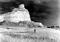
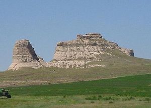
| Courthouse and Jail Rocks Courthouse and Jail Rocks Courthouse and Jail Rocks are two rock formations located near Bridgeport, Nebraska.The Oregon-California Trail, the Mormon Trail, the Pony Express Trail and the Sidney-Deadwood Trail all ran near the rocks. The pair of rock formations served as a landmark along the trails for many pioneers... |
Bridgeport Bridgeport, Nebraska Bridgeport is a city in Morrill County, Nebraska, United States. The population was 1,594 at the 2000 census. It is the county seat of Morrill County.-Geography:Bridgeport is located at .... |
Courthouse Rock is a sandstone outcropping south of the Oregon Trail. A smaller feature to the east is called the Jail Rock. |
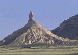
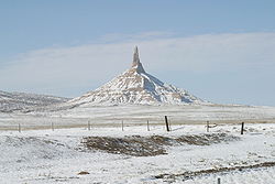
| Chimney Rock National Historic Site Chimney Rock National Historic Site Chimney Rock is a prominent geological rock formation in Morrill County in western Nebraska. Rising nearly 300 feet above the surrounding North Platte River valley, the peak of Chimney Rock is above sea level. During the middle 19th century it served as a landmark along the Oregon Trail, the... |
Bayard Bayard, Nebraska Bayard is a city in Morrill County, Nebraska, United States. The population was 1,247 at the 2000 census.-Geography:Bayard is located at .According to the United States Census Bureau, the city has a total area of , all of it land.... |
A clay and sandstone column resembling a tall factory chimney that is over 300 feet (91 m) today. |
| Rebecca Winter's Grave site Rebecca Winters (pioneer) Rebecca Burdick Winters was a Mormon pioneer who with her family left the eastern United States to emigrate to Utah with other Latter-day Saints. In August 1852, en route to Utah, she died of cholera near present day Scottsbluff, Nebraska... |
Scottsbluff Scottsbluff, Nebraska Scottsbluff is a city in Scotts Bluff County, Nebraska, United States. The population was 15,039 at the 2010 census. Scottsbluff is the largest city in the Nebraska Panhandle, and the 13th largest city in Nebraska.... |
Rebecca Winters of the Mormon pioneers died enroute to Salt Lake City. |
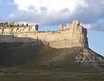
| Scotts Bluff | Gering Gering, Nebraska Gering is a city in Scotts Bluff County, Nebraska, United States. It is part of the Scottsbluff, Nebraska Micropolitan Statistical Area. The population was 7,751 at the 2000 census. It is the county seat of Scotts Bluff County.... |
A bluff over the North Platte River North Platte River The North Platte River is a major tributary of the Platte River and is approximately long counting its many curves, It travels about distance. Its course lies in the U.S... , now within Scotts Bluff National Monument Scotts Bluff National Monument Scotts Bluff National Monument in western Nebraska includes an important 19th century landmark on the Oregon Trail and Mormon Trail. The National Monument contains multiple bluffs located on the south side of the North Platte River; it is named for one prominent bluff called Scotts Bluff, which... . |
| Mitchell Pass Mitchell Pass Mitchell Pass is a gap which after 1851 replaced Robidoux Pass as a way through the Wildcat Hills on the Emigrant Trail near Scottsbluff, Nebraska. Mitchell Pass, immediately south of Scotts Bluff and directly west of Gering, Nebraska, eliminated a detour to the south more distant from the North... |
Gering | A gap in the Wildcat Hills Wildcat Hills The Wildcat Hills are an escarpment between the North Platte River and Pumpkin Creek in the western Nebraska Panhandle. Located in Banner, Morrill, and Scotts Bluff counties, the high tableland between the streams has been eroded by wind and water into a region of forested buttes, ridges and... used by travelers on the Emigrant Trail Emigrant Trail The Emigrant Trails were the northern networks of overland wagon trails throughout the American West, used by emigrants from the eastern United States to settle lands west of the Interior Plains during the overland migrations of the mid-19th century... after 1851 after improvement by the United States Army Corps of Engineers United States Army Corps of Engineers The United States Army Corps of Engineers is a federal agency and a major Army command made up of some 38,000 civilian and military personnel, making it the world's largest public engineering, design and construction management agency... , now within Scotts Bluff National Monument Scotts Bluff National Monument Scotts Bluff National Monument in western Nebraska includes an important 19th century landmark on the Oregon Trail and Mormon Trail. The National Monument contains multiple bluffs located on the south side of the North Platte River; it is named for one prominent bluff called Scotts Bluff, which... . |
| Pierre D. Papin Grave | Gering | Pierre was a well known trapper who died at nearby Fort John in May 1853. |
| Robidoux Trading Post | Gering | Small log trading post was established by Joseph E. Robidoux in late 1848. |