

Courthouse and Jail Rocks
Encyclopedia
Bridgeport, Nebraska
Bridgeport is a city in Morrill County, Nebraska, United States. The population was 1,594 at the 2000 census. It is the county seat of Morrill County.-Geography:Bridgeport is located at ....
.
The Oregon-California Trail
Oregon Trail
The Oregon Trail is a historic east-west wagon route that connected the Missouri River to valleys in Oregon and locations in between.After 1840 steam-powered riverboats and steamboats traversing up and down the Ohio, Mississippi and Missouri rivers sped settlement and development in the flat...
, the Mormon Trail
Mormon Trail
The Mormon Trail or Mormon Pioneer Trail is the 1,300 mile route that members of The Church of Jesus Christ of Latter-day Saints traveled from 1846 to 1868...
, the Pony Express
Pony Express
The Pony Express was a fast mail service crossing the Great Plains, the Rocky Mountains, and the High Sierra from St. Joseph, Missouri, to Sacramento, California, from April 3, 1860 to October 1861...
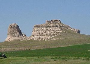
Trail and the Sidney-Deadwood Trail all ran near the rocks. The pair of rock formations served as a landmark along the trails for many pioneers traveling west in the 19th century. Many travelers would stray as much as five miles (8 km) from the Oregon Trail just to get a glimpse of the rocks.
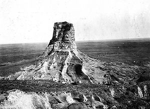
Hundreds of westward-bound emigrants mentioned Courthouse Rock (originally also McFarlan's Castle) in their travel logs and journals. The name "Courthouse" was first used in 1837. In 1845, one traveler described the rock as "resembling the ruins of an old castle [which] rises abruptly from the plain....It is difficult to look upon it and not believe that art had something to do with its construction. The voyagers have called it the Courthouse; but it looks infinitely more like the Capitol."
Courthouse and Jail Rocks, which rise 400 feet (121 m) above the North Platte Valley
North Platte River
The North Platte River is a major tributary of the Platte River and is approximately long counting its many curves, It travels about distance. Its course lies in the U.S...
, are composed of Brule clay, Gering sandstone and volcanic ash
Volcanic ash
Volcanic ash consists of small tephra, which are bits of pulverized rock and glass created by volcanic eruptions, less than in diameter. There are three mechanisms of volcanic ash formation: gas release under decompression causing magmatic eruptions; thermal contraction from chilling on contact...
. The rock formations are listed in the National Register of Historic Places
National Register of Historic Places
The National Register of Historic Places is the United States government's official list of districts, sites, buildings, structures, and objects deemed worthy of preservation...
and in the Nebraska Natural Areas Register.
The formation was the site of a rare microburst event on May 19, 2009, where wind speeds were sustained at over 60 mph for approximately 15 minutes, including several bursts over 80 mph and an incredible burst of 91 mph. This event was documented by a meteorologist on-site and a Weather Channel film crew.
The formation is the site of the annual Panhandle Astronomy Club's, Western Nebraska Star Gaze star party in June, since 2005. Chosen because it is a good dark site, close to Bridgeport with a nice view of the surrounding terrain.
See also
- Landmarks of the Nebraska TerritoryLandmarks of the Nebraska TerritoryLandmarks of the Nebraska Territory were important to settlers on the Oregon, California and Mormon trails. While the majority of the landmarks were close to the Platte River, others were spread across the state.-The trails:...
- Chimney Rock National Historic SiteChimney Rock National Historic SiteChimney Rock is a prominent geological rock formation in Morrill County in western Nebraska. Rising nearly 300 feet above the surrounding North Platte River valley, the peak of Chimney Rock is above sea level. During the middle 19th century it served as a landmark along the Oregon Trail, the...
- ButteButteA butte is a conspicuous isolated hill with steep, often vertical sides and a small, relatively flat top; it is smaller than mesas, plateaus, and table landform tables. In some regions, such as the north central and northwestern United States, the word is used for any hill...