

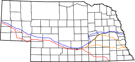
Platte River
Encyclopedia
The Platte River is a major river
in the state of Nebraska
and is about 310 mi (498.9 km) long. Measured to its farthest source via its tributary the North Platte River
, it flows for over 1050 miles (1,689.8 km). The Platte River is a tributary of the Missouri River
, which in turn is a tributary of the Mississippi River
which flows to the Gulf of Mexico
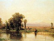
. The Platte over most of its length is a muddy, broad, shallow, meandering stream with a swampy bottom and many islands—a braided stream. These characteristics made it too difficult even for canoe travel, and it was never used as a major transportation route by European-American trappers or explorers.
The Platte is one of the most significant tributary systems in the watershed
of the Missouri, draining a large portion of the central Great Plains
in Nebraska
and the eastern Rocky Mountains
in Colorado
and Wyoming
. The river valley played an important role in the westward expansion of the United States, providing the route for several major emigrant trails, including the Oregon
, California
, Mormon
and Bozeman
trails. The first Europeans to see the Platte were French
explorers and fur trappers about 1714; they first called it the Nebraskier (Nebraska), a transliteration of the name given by the Otoe
people, meaning "flat water".
by the confluence of the North Platte
and the South Platte River
s, which both arise from snowmelt in the eastern Rockies east of the Continental Divide
.
In central north Colorado is the North Park (Colorado basin) valley, ringed by mountains of 12,000 feet (3,700 m) height; this is where the North Platte River
originates. The head of the North Platte River
is essentially all of Jackson County
; its boundaries are the continental divide on the east and south and the mountain drainage peaks on the east—the north boundary is the state of Wyoming. The nearest Colorado town is Walden
, the county seat. The rugged Rocky Mountains Continental Divide surrounding Jackson County have at least twelve peaks over 11,000 feet (3,400 m) in height. From Jackson County, the North Platte flows north about 200 miles (321.9 km) out of the Routt National Forest and North Park near what is now Walden to Casper, Wyoming
. Shortly after passing Casper, the North Platte turns to the east-southeast and flows about 350 miles (563.3 km) to the city of North Platte, Nebraska
. In Colorado and Wyoming, the North Platte is narrower and much swifter flowing than it is in Nebraska, where it becomes a slow flowing, shallow braided stream.
The North Platte River
has been dammed about eight times for water storage and irrigation purposes in Wyoming and Nebraska as it flows to its confluence with the South Platte River
. The upper reaches of the river in the Rockies in Colorado and Wyoming are popular for recreation rafting and lure and fly fishing
for rainbow
, brown
, cutthroat trout
and other sport fish. In western Nebraska, the banks and riverbed of the North Platte provide a green oasis amid an otherwise semi-arid region of North America. Today, by the time the North Platte reaches Paxton, Nebraska
it is much smaller due to the extensive water taken from it for irrigation. Historically, the North Platte River used to be up to a mile wide (1.6 km) in many places, as evidenced by the old streambed and historic written records.
The South Platte River
drainage includes about 28000 mi2 in the north east corner of Colorado, parts of southeastern Wyoming in the vicinity of the city of Cheyenne
and a small part of the southwest corner of Nebraska. The South Platte drains a large part of the Front Range
mountains east of the continental divide. The part of the river labeled the South Platte is formed in Park County, Colorado
, located southwest of Denver, in the South Park
grassland basin and mountains east of the continental divide. It is formed by the confluence of the South Fork South Platte River
and Middle Fork South Platte River
, approximately 15 miles (24.1 km) southeast of Fairplay, Colorado
. After the South and Middle fork join, the South Platte flows east-southeast till it exits Elevenmile Reservoir; it turns almost ninety degrees to skirt the west side of Pikes Peak
and flows roughly east-northeast about 100 miles (160.9 km) through Denver and on to Greeley, Colorado
. From Greeley, the South Platte turns east and flows about 200 miles (321.9 km) to its confluence with the North Platte River near the city of North Platte, Nebraska
.
The South Platte River
has been dammed about twenty times for water storage, drinking water and irrigation purposes in Colorado as it flows to its confluence with the North Platte River. The total number of dams in the South Platte drainage may exceed 1,000 as nearly all major streams have at least one dam on them. The South Platte River serves as the principal source of water for arid eastern Colorado. The South Platte River valley provided a major emigration path to Denver. The wagon trails followed the south side of the Platte/North Platte River. Wagon trains were ferried or waded in low water years across the swampy-bottomed South Platte River in several places to stay on the south side of the North Platte River where the trails were located. Miners who later went on to Denver followed the South Platte River trail into Colorado.
 After the North Platte and the South Platte rivers join to form the Platte River, over most of its length it is a muddy, broad, shallow, meandering stream with a swampy bottom and many islands—a braided stream. Its muddy water, many shallow channels and islands and ever-changing mud bars made it too difficult for even canoe travel; it was never used as a major water transportation route. The Platte flows in a large arc, east-southeast to near Fort Kearny
and then east-northeast, across Nebraska south of Grand Island
and on to Columbus
. The Platte River is joined from the north by the about 70 miles (112.7 km) long Loup River
about 5 miles (8 km) southeast of Columbus. During pioneer days, a Loup River ferry crossed the river. From Columbus, the Platte flows almost due east about 50 miles (80.5 km) past North Bend
and then on to Fremont
.
Near Fremont, the Platte bends south and then east around the location of Omaha
in a large "L" turn. Near Fremont the Platte turns sharply and flows south-southeast about 10 miles (16.1 km) to about Waterloo, Nebraska
--located about 20 miles (32.2 km) west of Omaha. Near Waterloo the Platte turns even more and heads almost due south for about 10 miles (16.1 km). About 30 miles (48.3 km) east-southeast of Waterloo and about 30 miles (48.3 km) from the Platte's confluence with the Missouri River
, the Platte is joined from the north by the Elkhorn River
. The Elkhorn, a 290 miles (466.7 km) long river, originates in the eastern Sandhills of Nebraska
and is one of the largest tributaries of the Platte River. The Elkhorn joins the Platte on its south-bound path just southwest of Omaha, approximately 1 mile (2 km) south and 3 miles (5 km) west of Gretna
. The pioneers leaving from near Omaha (established 1854) or Council Bluffs, Iowa
(established 1846) used the Mormon Trail
north of the Platte River and had to ferry across the Elkhorn. After the Union Pacific railroad was constructed west from Omaha in 1866, it had to build a major bridge across the Elkhorn. After the confluence of the Elkhorn and the Platte River, the Platte continues southward, about 7 miles (11.3 km) miles before it turns sharply and heads almost due East for about 20 miles (32.2 km) before its confluence with the Missouri River
. Sarpy County
is shaped like a crescent, being bounded on the east by the Missouri River, on the south and west by the Platte, and on the north by Douglas County
which contains Omaha. The Platte-Missouri River
confluence is about 10 miles (16.1 km) south of Omaha.
Including the North Platte River
, the Platte River stretches over 850 miles (1,367.9 km), with a drainage basin of about 90000 square miles (233,098.9 km²). The mean annual flow is estimated at 3240 cuft/s. The Platte drains one of the most arid areas of the Great Plains
with a flow that is considerably lower than rivers of comparable length in North America. For much of its length, it is a classic wide, muddy and shallow braided stream which in the lower reaches flows in a floodplain bordered by bluffs. During pioneer days, the common humorous description was that the Platte was "a mile wide at the mouth, but only six inches deep." 49ers said it was "too thick to drink, too thin to plow". In western Nebraska, the banks and riverbed of the Platte provide a green oasis amid an otherwise semi-arid region of North America. The central Platte River valley is an important stopover for migratory water birds, such as the Whooping Crane
and Sandhill Crane
, in their yearly traversal of the Central Flyway
. A decent map of the Platte and other rivers in Nebraska is at the geology.com site.
Since the mid-20th century, this river has shrunk significantly. This reduction in size is attributed in part to its waters being used for irrigation, and to a much greater extent to the waters diverted and used by the growing population of Colorado, which has outstripped the ability of its groundwater to sustain them.
 Varying cultures of indigenous peoples
lived intermittently along the Platte for thousands of years before European exploration. Historical tribes claimed various territories in the region. The Indian tribes typically visited different areas in different seasons, as they followed the bison
herds for hunting periods. The introduction of horses, which had escaped from early Spanish explorers in the 1540s, dramatically changed life in the Great Plains. Indian tribes could more easily follow the buffalo herds as they migrated from north to south and back. Before 1870, herds of several 100,000 buffalo
periodically migrated across the Platte in following seasonal pasture. The animals often waded or swam across the Platte. The first-known Europe
an to see the Platte was the French explorer Étienne de Veniard, sieur de Bourgmont
in 1714, who named it the Nebraskier, after its Oto
name, meaning "flat water". The French later applied the French
word plate (meaning flat, and pronounced plat, or platte) to the river.
Occupied by various Indian tribes for part of each year, the Platte River territory had been claimed by both Spanish
and French
explorers trying to rule the Great Plains
. Spain had "claimed" all of the Great Plains after Coronado's 1541-42 expedition. Jose Naranjo
, an African-Hopi
who served as a Spanish scout and explorer in the Southwest
, was a war captain of the Spanish Indian auxiliaries. By 1714 (the same year the French explorers "discovered" the Platte), he and a small exploration group from the south had reportedly already reached the Platte three times. He later guided the 1720 Villasur expedition
to the area in a Spanish effort to stop French expansion onto the Great Plains. Naranjo and Villasur's party made the most northern of Spanish exploration
trips into the central plains. A Pawnee
and Otoe
Indian attack defeated the Spanish forces; the survivors returned to Santa Fe, New Mexico
, and the Spanish left the Great Plains to the American Indians.
As a result of the Seven Years War (1756–1763) (called the French and Indian War
in America), the French ceded all of their lands in North America east of the Mississippi River to the British. The Spanish took over lands west of the Mississippi River. Since there were few fur-bearing
animals on the Platte of interest to the fur traders, the French and British explorers and fur trappers ignored the Platte territory for some time. During the course of the Napoleonic Wars
(1803–1815), France briefly reacquired the land west of the Mississippi River from Spain.
In 1804, Napoleon sold the area west of the Mississippi River
to the United States in the Louisiana Purchase
; the US roughly doubled its area at a cost of about $15,000,000. In 1820 the U.S. Army ordered Major Stephen H. Long to explore and map the area around the Platte. Long reported the area as a great American "desert," ignoring that the "desert" provided habitat for more than a million buffalo and numerous American Indians had long lived in the area. As a result of his and other reports, the United States initially had little interest in settling the land on the plains. The next "good" land was believed to be in Oregon
or California
, especially the coastal areas, and those were the destinations of most emigrant traffic. The Mormons
settled Utah
, largely due to religious persecution in eastern areas. Various gold and silver strikes attracted further emigration to nearly all western states.
The Native American trail west along the Platte, North Platte River and Sweetwater River
was first written about after its discovery in 1811 by Wilson Price Hunt of the Astor Expedition
. He was returning to the Missouri River
posts from the newly established Fort Astoria
on the Columbia River
near the Pacific Ocean. Because few American trappers and settlers were then in the contested Oregon Territory
, his trail discovery was little used and nearly forgotten.
In 1823 Jedediah Smith
and several trappers "rediscovered" the route. The trail along the Platte, North Platte and Sweetwater rivers became a major route of fur traders to their summer Rocky Mountain Rendezvous. In 1824 fur trappers and traders directing mule trains carrying trade goods and supplies for the mountain men
were some of the first European-American parties to use the trail. On their return trip, the fur traders carried out for furs destined for eastern markets. The fur trade route was used to about 1840.
By about 1832, the fur traders had improved the trail along the Platte, North Platte, and Sweetwater rivers to a rough wagon trail from the Missouri River to the Green River
in Wyoming, where most of the Rocky Mountain Rendezvous were held. In 1834 Benjamin Bonneville
, a United States Army officer on leave, led an expedition to the west financed by John Jacob Astor
. They took wagons along the Platte, North Platte and Sweetwater River trail to the Green River in present-day Wyoming. The notable author Washington Irving
wrote an account of Bonneville's explorations in the west that made him well-known in the United States.
 Following the fur traders, the major emigration trails established along the north and south banks of the Platte and North Platte River were the Oregon
(1843–1869), California
(1843–1869), Mormon
(1847–1869) and the Bozeman
(1863–68) trails. This network of trails, sometimes called the Emigrant Trails or the Great Platte River Road
, all went west along both sides of the Platte River. The route along the Platte River included all these emigration trails and was developed as an important trail route used by migrant wagon train
s for westward United States expansion after 1841. The settlement of the Oregon boundary dispute
with Britain in 1846, the conclusion of the Mexican American War in 1848, and the California Gold Rush
in 1849 and other gold and silver strikes rapidly attracted increased emigrant traffic west.
The Platte River in the future state of Nebraska and the North Platte River
in Wyoming typically had many channels and islands. The waterways were often too shallow, crooked, muddy and unpredictable for even a canoe to travel far. The Platte River valley provided an easily passable wagon corridor; it sloped gradually up in height as it went almost due west from the Missouri. The Platte route had access to water, grass, buffalo and buffalo 'chips,' which the Indians and emigrants used as fuel for fires. Long Native American use had created trails on both sides of the muddy, about 1 miles (1.6 km) wide and shallow (2 inches (5.1 cm) to 60 inches (152.4 cm)) Platte River. The Platte's water was silty and bad tasting, but it was usable if no other water was available. Emigrants learned to let it sit in a bucket for an hour or so to settle most of the silt. The trail(s) through the Platte River Valley extended about 450 miles (724.2 km) in the present state of Nebraska
. Nearly all the trails from the Missouri converged on the Platte River at or before Fort Kearny
in mid-state Nebraska. Historians have estimated about 400,000 emigrants followed the trails along the Platte.
The Pony Express
, operational from 1860–61, and the First Transcontinental Telegraph
, completed in 1861, both followed the earlier emigrant trails along the Platte. The completion of the telegraph put the Pony Express out of business as it could provide much faster east-west communication. In 1866 the Union Pacific
portion of the first transcontinental railroad was constructed along the Platte River as it started west from Omaha. In the 20th century, the Lincoln Highway
and later Interstate 80
were constructed through the Platte valley; the highways parallel the Platte and the North Platte through much of Nebraska.
Many of Nebraska’s larger cities originated on or near the Platte River, as it was the first path of transportation. These include Omaha (est. 1854), Fort Kearny (est. 1848), Grand Island
(est. 1857) and North Platte
(est. 1869). In 1859 settlers built the first irrigation
ditch to divert water from the Platte for farming.
, a primary North-South corridor for migratory birds from their summer nesting grounds in the north (Alaska
and Canada
), south for the winter, and the return in the spring. The Central Flyway
bird species include trumpeter swan
s, tundra swans, over one million Canadian geese, Greater White-fronted Geese, Sandhill Crane
s, Canvasback ducks and others. Other species such as bald eagles, heron
s and several species of duck
s migrate through the Platte River area but over shorter distances. The Whooping Crane
, Piping Plover
, and the Interior Least Tern are birds using the flyway which have been classified as endangered and are protected under the Platte River Endangered Species Partnership.
Common plants in the Platte River area are Big and Little Bluestem, switch grass, and cottonwood trees. White-tail deer, many types of catfish, Canada geese, and bald eagles attract fans. The Platte River area has long supported many animals but recently, due to urbanization and farming causing loss of habitat, the numbers have declined. Canadian geese have adapted to the farm fields and scavenge a large part of their fare from unharvested grain; many have taken up residence at suburban office parks and stopped seasonal migrations.
 The Platte River flowing through an arid part of the mid-west has been widely overused. Unfortunately, the claims on the Platte River water have exceeded the supply of water in drier years. The criteria for water over appropriation, according to the final reading of LB 962, is that if the river basin, sub basin, or reach is subject to an interstate cooperative agreement among three or more states and if, prior to such date, the department has declared a moratorium on the issuance of new surface water appropriations in such river basin, sub basin or reach and has requested each natural resource district with jurisdiction in the affected area in such river basin, sub basin or reach either to close or to continue in effect a previously adopted closure of all or part of such river basin, sub basin, or reach to the issuance of additional water well permits in accordance with subdivision. Most of the Platte River basin is currently considered as overappropriated.
Beginning in 2004, a number of Nebraska stakeholders embarked upon the Platte River Cooperative Hydrology Study (COHYST). Conducted with assistance from the United States Geological Survey and the Natural Resources Conservation Service, this study attempts to arrive at a better understanding of the geology and hydrology of the Platte River basin from the Colorado and Wyoming borders to Columbus, including the Loup basin. This improved understanding could be used to develop policies for management of the river system, both for human use and for the sake of the basin's endangered species. As of October 2009, the study is still ongoing.
, James A. Michener
's epic novel about the West from prehistoric to modern times, the second chapter is about the geological history of the Platte River tributary. The river as stopover for sandhill crane
s plays an important part in Richard Powers
' 2006 novel The Echo Maker
.
The South Park episode "The Tooth Fairy Tale 2000" features Kenny being thrown into the Platte River with concrete shoes on.
River
A river is a natural watercourse, usually freshwater, flowing towards an ocean, a lake, a sea, or another river. In a few cases, a river simply flows into the ground or dries up completely before reaching another body of water. Small rivers may also be called by several other names, including...
in the state of Nebraska
Nebraska
Nebraska is a state on the Great Plains of the Midwestern United States. The state's capital is Lincoln and its largest city is Omaha, on the Missouri River....
and is about 310 mi (498.9 km) long. Measured to its farthest source via its tributary the North Platte River
North Platte River
The North Platte River is a major tributary of the Platte River and is approximately long counting its many curves, It travels about distance. Its course lies in the U.S...
, it flows for over 1050 miles (1,689.8 km). The Platte River is a tributary of the Missouri River
Missouri River
The Missouri River flows through the central United States, and is a tributary of the Mississippi River. It is the longest river in North America and drains the third largest area, though only the thirteenth largest by discharge. The Missouri's watershed encompasses most of the American Great...
, which in turn is a tributary of the Mississippi River
Mississippi River
The Mississippi River is the largest river system in North America. Flowing entirely in the United States, this river rises in western Minnesota and meanders slowly southwards for to the Mississippi River Delta at the Gulf of Mexico. With its many tributaries, the Mississippi's watershed drains...
which flows to the Gulf of Mexico
Gulf of Mexico
The Gulf of Mexico is a partially landlocked ocean basin largely surrounded by the North American continent and the island of Cuba. It is bounded on the northeast, north and northwest by the Gulf Coast of the United States, on the southwest and south by Mexico, and on the southeast by Cuba. In...
. The Platte over most of its length is a muddy, broad, shallow, meandering stream with a swampy bottom and many islands—a braided stream. These characteristics made it too difficult even for canoe travel, and it was never used as a major transportation route by European-American trappers or explorers.
The Platte is one of the most significant tributary systems in the watershed
Drainage basin
A drainage basin is an extent or an area of land where surface water from rain and melting snow or ice converges to a single point, usually the exit of the basin, where the waters join another waterbody, such as a river, lake, reservoir, estuary, wetland, sea, or ocean...
of the Missouri, draining a large portion of the central Great Plains
Great Plains
The Great Plains are a broad expanse of flat land, much of it covered in prairie, steppe and grassland, which lies west of the Mississippi River and east of the Rocky Mountains in the United States and Canada. This area covers parts of the U.S...
in Nebraska
Nebraska
Nebraska is a state on the Great Plains of the Midwestern United States. The state's capital is Lincoln and its largest city is Omaha, on the Missouri River....
and the eastern Rocky Mountains
Rocky Mountains
The Rocky Mountains are a major mountain range in western North America. The Rocky Mountains stretch more than from the northernmost part of British Columbia, in western Canada, to New Mexico, in the southwestern United States...
in Colorado
Colorado
Colorado is a U.S. state that encompasses much of the Rocky Mountains as well as the northeastern portion of the Colorado Plateau and the western edge of the Great Plains...
and Wyoming
Wyoming
Wyoming is a state in the mountain region of the Western United States. The western two thirds of the state is covered mostly with the mountain ranges and rangelands in the foothills of the Eastern Rocky Mountains, while the eastern third of the state is high elevation prairie known as the High...
. The river valley played an important role in the westward expansion of the United States, providing the route for several major emigrant trails, including the Oregon
Oregon Trail
The Oregon Trail is a historic east-west wagon route that connected the Missouri River to valleys in Oregon and locations in between.After 1840 steam-powered riverboats and steamboats traversing up and down the Ohio, Mississippi and Missouri rivers sped settlement and development in the flat...
, California
California Trail
The California Trail was an emigrant trail of about across the western half of the North American continent from Missouri River towns to what is now the state of California...
, Mormon
Mormon Trail
The Mormon Trail or Mormon Pioneer Trail is the 1,300 mile route that members of The Church of Jesus Christ of Latter-day Saints traveled from 1846 to 1868...
and Bozeman
Bozeman Trail
The Bozeman Trail was an overland route connecting the gold rush territory of Montana to the Oregon Trail. Its most important period was from 1863-1868. The flow of pioneers and settlers through territory of American Indians provoked their resentment and caused attacks. The U.S. Army undertook...
trails. The first Europeans to see the Platte were French
France
The French Republic , The French Republic , The French Republic , (commonly known as France , is a unitary semi-presidential republic in Western Europe with several overseas territories and islands located on other continents and in the Indian, Pacific, and Atlantic oceans. Metropolitan France...
explorers and fur trappers about 1714; they first called it the Nebraskier (Nebraska), a transliteration of the name given by the Otoe
Otoe
Otoe may refer to*Otoe tribe, a Native American people*Otoe-Missouria Tribe of Indians, a federally recognized tribe in Oklahoma*Otoe, Nebraska*Otoe County, Nebraska...
people, meaning "flat water".
Headwaters
The Platte River is formed in western Nebraska east of the city of North Platte, NebraskaNorth Platte, Nebraska
North Platte is a city in and the county seat of Lincoln County, Nebraska, United States. It is located in the southwestern part of the state, along Interstate 80, at the confluence of the North and South Platte Rivers forming the Platte River...
by the confluence of the North Platte
North Platte River
The North Platte River is a major tributary of the Platte River and is approximately long counting its many curves, It travels about distance. Its course lies in the U.S...
and the South Platte River
South Platte River
The South Platte River is one of the two principal tributaries of the Platte River and itself a major river of the American Midwest and the American Southwest/Mountain West, located in the U.S. states of Colorado and Nebraska...
s, which both arise from snowmelt in the eastern Rockies east of the Continental Divide
Continental Divide
The Continental Divide of the Americas, or merely the Continental Gulf of Division or Great Divide, is the name given to the principal, and largely mountainous, hydrological divide of the Americas that separates the watersheds that drain into the Pacific Ocean from those river systems that drain...
.
In central north Colorado is the North Park (Colorado basin) valley, ringed by mountains of 12,000 feet (3,700 m) height; this is where the North Platte River
North Platte River
The North Platte River is a major tributary of the Platte River and is approximately long counting its many curves, It travels about distance. Its course lies in the U.S...
originates. The head of the North Platte River
North Platte River
The North Platte River is a major tributary of the Platte River and is approximately long counting its many curves, It travels about distance. Its course lies in the U.S...
is essentially all of Jackson County
Jackson County, Colorado
Jackson County is the fourth-least densely populated of the Colorado 64 counties of the U.S. state of Colorado. The county population was 1,577 at the 2000 Census. The county seat and the only municipality in the county is the Town of Walden.- History :...
; its boundaries are the continental divide on the east and south and the mountain drainage peaks on the east—the north boundary is the state of Wyoming. The nearest Colorado town is Walden
Walden, Colorado
The Town of Walden is a Statutory Town that is the county seat of, and the only incorporated municipality in, Jackson County, Colorado, United States. It is situated in the center of a large open valley called North Park. People from Walden and the surrounding area refer to themselves as "North...
, the county seat. The rugged Rocky Mountains Continental Divide surrounding Jackson County have at least twelve peaks over 11,000 feet (3,400 m) in height. From Jackson County, the North Platte flows north about 200 miles (321.9 km) out of the Routt National Forest and North Park near what is now Walden to Casper, Wyoming
Casper, Wyoming
Casper is the county seat of Natrona County, Wyoming, United States.. Casper is the second-largest city in Wyoming , according to the 2010 census, with a population of 55,316...
. Shortly after passing Casper, the North Platte turns to the east-southeast and flows about 350 miles (563.3 km) to the city of North Platte, Nebraska
North Platte, Nebraska
North Platte is a city in and the county seat of Lincoln County, Nebraska, United States. It is located in the southwestern part of the state, along Interstate 80, at the confluence of the North and South Platte Rivers forming the Platte River...
. In Colorado and Wyoming, the North Platte is narrower and much swifter flowing than it is in Nebraska, where it becomes a slow flowing, shallow braided stream.
The North Platte River
North Platte River
The North Platte River is a major tributary of the Platte River and is approximately long counting its many curves, It travels about distance. Its course lies in the U.S...
has been dammed about eight times for water storage and irrigation purposes in Wyoming and Nebraska as it flows to its confluence with the South Platte River
South Platte River
The South Platte River is one of the two principal tributaries of the Platte River and itself a major river of the American Midwest and the American Southwest/Mountain West, located in the U.S. states of Colorado and Nebraska...
. The upper reaches of the river in the Rockies in Colorado and Wyoming are popular for recreation rafting and lure and fly fishing
Fly fishing
Fly fishing is an angling method in which an artificial 'fly' is used to catch fish. The fly is cast using a fly rod, reel, and specialized weighted line. Casting a nearly weightless fly or 'lure' requires casting techniques significantly different from other forms of casting...
for rainbow
Rainbow trout
The rainbow trout is a species of salmonid native to tributaries of the Pacific Ocean in Asia and North America. The steelhead is a sea run rainbow trout usually returning to freshwater to spawn after 2 to 3 years at sea. In other words, rainbow trout and steelhead trout are the same species....
, brown
Brown trout
The brown trout and the sea trout are fish of the same species....
, cutthroat trout
Cutthroat trout
The cutthroat trout is a species of freshwater fish in the salmon family of order Salmoniformes. It is one of the many fish species colloquially known as trout...
and other sport fish. In western Nebraska, the banks and riverbed of the North Platte provide a green oasis amid an otherwise semi-arid region of North America. Today, by the time the North Platte reaches Paxton, Nebraska
Paxton, Nebraska
Paxton is a village in Keith County, Nebraska, United States. The population was 614 at the 2000 census.-Geography:According to the United States Census Bureau, the village has a total area of , all of it land.-Demographics:...
it is much smaller due to the extensive water taken from it for irrigation. Historically, the North Platte River used to be up to a mile wide (1.6 km) in many places, as evidenced by the old streambed and historic written records.
The South Platte River
South Platte River
The South Platte River is one of the two principal tributaries of the Platte River and itself a major river of the American Midwest and the American Southwest/Mountain West, located in the U.S. states of Colorado and Nebraska...
drainage includes about 28000 mi2 in the north east corner of Colorado, parts of southeastern Wyoming in the vicinity of the city of Cheyenne
Cheyenne, Wyoming
Cheyenne is the capital and most populous city of the U.S. state of Wyoming and the county seat of Laramie County. It is the principal city of the Cheyenne, Wyoming, Metropolitan Statistical Area which encompasses all of Laramie County. The population is 59,466 at the 2010 census. Cheyenne is the...
and a small part of the southwest corner of Nebraska. The South Platte drains a large part of the Front Range
Front Range
The Front Range is a mountain range of the Southern Rocky Mountains of North America located in the north-central portion of the U.S. State of Colorado and southeastern portion of the U.S. State of Wyoming. It is the first mountain range encountered moving west along the 40th parallel north across...
mountains east of the continental divide. The part of the river labeled the South Platte is formed in Park County, Colorado
Park County, Colorado
Park County is the 17th most extensive of the 64 counties of the State of Colorado of the United States. The county was named after the large geographic region known as South Park, which was named by early fur traders and trappers in the area. The geographic center of the State of Colorado is...
, located southwest of Denver, in the South Park
South Park (Colorado basin)
South Park is a high intermontane grassland basin, approximately 10,000 ft in elevation, in the Rocky Mountains of central Colorado. It encompasses approximately 1,000 square miles around the headwaters of the South Platte River in Park County approximately 60 mi southwest of Denver...
grassland basin and mountains east of the continental divide. It is formed by the confluence of the South Fork South Platte River
South Fork South Platte River
The South Fork South Platte River is a tributary of the South Platte River, approximately long, in central Colorado in the United States. It is located near the headwaters of the South Platte in Park County, Colorado and drains part of the intermontane grassland basin of South Park...
and Middle Fork South Platte River
Middle Fork South Platte River
The Middle Fork South Platte River is a tributary of the South Platte River, approximately long, located in central Colorado in the United States...
, approximately 15 miles (24.1 km) southeast of Fairplay, Colorado
Fairplay, Colorado
The Town of Fairplay is a statutory town that is the county seat and the most populous town of Park County, Colorado, United States. Fairplay is located in South Park at an elevation of . The town is the fifth-highest incorporated place in the State of Colorado. The population was 610 at the...
. After the South and Middle fork join, the South Platte flows east-southeast till it exits Elevenmile Reservoir; it turns almost ninety degrees to skirt the west side of Pikes Peak
Pikes Peak
Pikes Peak is a mountain in the Front Range of the Rocky Mountains, west of Colorado Springs, Colorado, in El Paso County in the United States of America....
and flows roughly east-northeast about 100 miles (160.9 km) through Denver and on to Greeley, Colorado
Greeley, Colorado
The City of Greeley is a Home Rule Municipality that is the county seat and the most populous city of Weld County, Colorado, United States. Greeley is located in the region known as Northern Colorado. Greeley is situated north-northeast of the Colorado State Capitol in Denver. According to the...
. From Greeley, the South Platte turns east and flows about 200 miles (321.9 km) to its confluence with the North Platte River near the city of North Platte, Nebraska
North Platte, Nebraska
North Platte is a city in and the county seat of Lincoln County, Nebraska, United States. It is located in the southwestern part of the state, along Interstate 80, at the confluence of the North and South Platte Rivers forming the Platte River...
.
The South Platte River
South Platte River
The South Platte River is one of the two principal tributaries of the Platte River and itself a major river of the American Midwest and the American Southwest/Mountain West, located in the U.S. states of Colorado and Nebraska...
has been dammed about twenty times for water storage, drinking water and irrigation purposes in Colorado as it flows to its confluence with the North Platte River. The total number of dams in the South Platte drainage may exceed 1,000 as nearly all major streams have at least one dam on them. The South Platte River serves as the principal source of water for arid eastern Colorado. The South Platte River valley provided a major emigration path to Denver. The wagon trails followed the south side of the Platte/North Platte River. Wagon trains were ferried or waded in low water years across the swampy-bottomed South Platte River in several places to stay on the south side of the North Platte River where the trails were located. Miners who later went on to Denver followed the South Platte River trail into Colorado.
Main stem
Fort Kearny
Fort Kearny was a historic outpost of the United States Army founded in 1848 in the western U.S. during the middle and late 19th century. The outpost was located along the Oregon Trail near present-day Kearney, Nebraska, which took its name from the fort .-Origins and various missions of the...
and then east-northeast, across Nebraska south of Grand Island
Grand Island, Nebraska
Grand Island is a city in and the county seat of Hall County, Nebraska, United States. The population was 48,520 at the 2010 census.Grand Island is home to the Nebraska Law Enforcement Training Center which is the sole agency responsible for training law enforcement officers throughout the state,...
and on to Columbus
Columbus, Nebraska
Columbus is a city in east central Nebraska, United States. Its population was 22,111 at the 2010 census. It is the county seat of Platte County.-Pre-settlement history:...
. The Platte River is joined from the north by the about 70 miles (112.7 km) long Loup River
Loup River
The Loup River is a tributary of the Platte River, approximately long, in central Nebraska in the United States. The river drains a sparsely populated rural agricultural area on the eastern edge of the Great Plains southeast of the Sandhills...
about 5 miles (8 km) southeast of Columbus. During pioneer days, a Loup River ferry crossed the river. From Columbus, the Platte flows almost due east about 50 miles (80.5 km) past North Bend
North Bend, Nebraska
North Bend is a city in Dodge County, Nebraska, United States. The population was 1,213 at the 2000 census.-Geography:North Bend is located at . It lies on the north bank of the Platte River, at the intersection of U.S. Highway 30 and Nebraska Highway 79...
and then on to Fremont
Fremont, Nebraska
Fremont is a city in and the county seat of Dodge County, Nebraska, United States, near Omaha in the eastern part of the state. The population was 26,397 at the 2010 census....
.
Near Fremont, the Platte bends south and then east around the location of Omaha
Omaha, Nebraska
Omaha is the largest city in the state of Nebraska, United States, and is the county seat of Douglas County. It is located in the Midwestern United States on the Missouri River, about 20 miles north of the mouth of the Platte River...
in a large "L" turn. Near Fremont the Platte turns sharply and flows south-southeast about 10 miles (16.1 km) to about Waterloo, Nebraska
Waterloo, Nebraska
Waterloo is a village in Douglas County, Nebraska, United States. The population was 459 at the 2000 census.-Geography:Waterloo is located at ....
--located about 20 miles (32.2 km) west of Omaha. Near Waterloo the Platte turns even more and heads almost due south for about 10 miles (16.1 km). About 30 miles (48.3 km) east-southeast of Waterloo and about 30 miles (48.3 km) from the Platte's confluence with the Missouri River
Missouri River
The Missouri River flows through the central United States, and is a tributary of the Mississippi River. It is the longest river in North America and drains the third largest area, though only the thirteenth largest by discharge. The Missouri's watershed encompasses most of the American Great...
, the Platte is joined from the north by the Elkhorn River
Elkhorn River
The Elkhorn River originates in the eastern Sandhills of Nebraska and is one of the largest tributaries of the Platte River, flowing and joining the Platte just southwest of Omaha, approximately 1 mile south and 3 miles west of Gretna.Located in northeast and north-central Nebraska, the Elkhorn...
. The Elkhorn, a 290 miles (466.7 km) long river, originates in the eastern Sandhills of Nebraska
Nebraska
Nebraska is a state on the Great Plains of the Midwestern United States. The state's capital is Lincoln and its largest city is Omaha, on the Missouri River....
and is one of the largest tributaries of the Platte River. The Elkhorn joins the Platte on its south-bound path just southwest of Omaha, approximately 1 mile (2 km) south and 3 miles (5 km) west of Gretna
Gretna, Nebraska
Gretna is a city in Sarpy County, Nebraska, United States. The population was 2,355 at the 2000 census. In 2008, its population was estimated to be 6,572. Gretna has the fastest rate of growth of any Nebraska city since 2000.-History:...
. The pioneers leaving from near Omaha (established 1854) or Council Bluffs, Iowa
Council Bluffs, Iowa
Council Bluffs, known until 1852 as Kanesville, Iowathe historic starting point of the Mormon Trail and eventual northernmost anchor town of the other emigrant trailsis a city in and the county seat of Pottawattamie County, Iowa, United States and is on the east bank of the Missouri River across...
(established 1846) used the Mormon Trail
Mormon Trail
The Mormon Trail or Mormon Pioneer Trail is the 1,300 mile route that members of The Church of Jesus Christ of Latter-day Saints traveled from 1846 to 1868...
north of the Platte River and had to ferry across the Elkhorn. After the Union Pacific railroad was constructed west from Omaha in 1866, it had to build a major bridge across the Elkhorn. After the confluence of the Elkhorn and the Platte River, the Platte continues southward, about 7 miles (11.3 km) miles before it turns sharply and heads almost due East for about 20 miles (32.2 km) before its confluence with the Missouri River
Missouri River
The Missouri River flows through the central United States, and is a tributary of the Mississippi River. It is the longest river in North America and drains the third largest area, though only the thirteenth largest by discharge. The Missouri's watershed encompasses most of the American Great...
. Sarpy County
Sarpy County, Nebraska
-Demographics:As of the census of 2000, there were 122,595 people, 43,426 households, and 33,220 families residing in the county. The population density was 510 people per square mile . There were 44,981 housing units at an average density of 187 per square mile...
is shaped like a crescent, being bounded on the east by the Missouri River, on the south and west by the Platte, and on the north by Douglas County
Douglas County, Nebraska
-Demographics:As of the census of 2000, there were 463,585 people, 182,194 households, and 115,146 families residing in the county. The population density was 1,401 people per square mile . There were 192,672 housing units at an average density of 582 per square mile...
which contains Omaha. The Platte-Missouri River
Missouri River
The Missouri River flows through the central United States, and is a tributary of the Mississippi River. It is the longest river in North America and drains the third largest area, though only the thirteenth largest by discharge. The Missouri's watershed encompasses most of the American Great...
confluence is about 10 miles (16.1 km) south of Omaha.
Including the North Platte River
North Platte River
The North Platte River is a major tributary of the Platte River and is approximately long counting its many curves, It travels about distance. Its course lies in the U.S...
, the Platte River stretches over 850 miles (1,367.9 km), with a drainage basin of about 90000 square miles (233,098.9 km²). The mean annual flow is estimated at 3240 cuft/s. The Platte drains one of the most arid areas of the Great Plains
Great Plains
The Great Plains are a broad expanse of flat land, much of it covered in prairie, steppe and grassland, which lies west of the Mississippi River and east of the Rocky Mountains in the United States and Canada. This area covers parts of the U.S...
with a flow that is considerably lower than rivers of comparable length in North America. For much of its length, it is a classic wide, muddy and shallow braided stream which in the lower reaches flows in a floodplain bordered by bluffs. During pioneer days, the common humorous description was that the Platte was "a mile wide at the mouth, but only six inches deep." 49ers said it was "too thick to drink, too thin to plow". In western Nebraska, the banks and riverbed of the Platte provide a green oasis amid an otherwise semi-arid region of North America. The central Platte River valley is an important stopover for migratory water birds, such as the Whooping Crane
Whooping Crane
The whooping crane , the tallest North American bird, is an endangered crane species named for its whooping sound. Along with the Sandhill Crane, it is one of only two crane species found in North America. The whooping crane's lifespan is estimated to be 22 to 24 years in the wild...
and Sandhill Crane
Sandhill Crane
The Sandhill Crane is a large crane of North America and extreme northeastern Siberia. The common name of this bird references habitat like that at the Platte River, on the edge of Nebraska's Sandhills in the American Midwest...
, in their yearly traversal of the Central Flyway
Central Flyway
The Central Flyway is a bird migration route that generally follows the Great Plains in the United States and Canada. The main endpoints of the flyway include central Canada and the region surrounding the Gulf of Mexico; the migration route tends to narrow considerably in the Platte River and...
. A decent map of the Platte and other rivers in Nebraska is at the geology.com site.
Since the mid-20th century, this river has shrunk significantly. This reduction in size is attributed in part to its waters being used for irrigation, and to a much greater extent to the waters diverted and used by the growing population of Colorado, which has outstripped the ability of its groundwater to sustain them.
History
Indigenous peoples
Indigenous peoples are ethnic groups that are defined as indigenous according to one of the various definitions of the term, there is no universally accepted definition but most of which carry connotations of being the "original inhabitants" of a territory....
lived intermittently along the Platte for thousands of years before European exploration. Historical tribes claimed various territories in the region. The Indian tribes typically visited different areas in different seasons, as they followed the bison
Bison
Members of the genus Bison are large, even-toed ungulates within the subfamily Bovinae. Two extant and four extinct species are recognized...
herds for hunting periods. The introduction of horses, which had escaped from early Spanish explorers in the 1540s, dramatically changed life in the Great Plains. Indian tribes could more easily follow the buffalo herds as they migrated from north to south and back. Before 1870, herds of several 100,000 buffalo
Bison
Members of the genus Bison are large, even-toed ungulates within the subfamily Bovinae. Two extant and four extinct species are recognized...
periodically migrated across the Platte in following seasonal pasture. The animals often waded or swam across the Platte. The first-known Europe
Europe
Europe is, by convention, one of the world's seven continents. Comprising the westernmost peninsula of Eurasia, Europe is generally 'divided' from Asia to its east by the watershed divides of the Ural and Caucasus Mountains, the Ural River, the Caspian and Black Seas, and the waterways connecting...
an to see the Platte was the French explorer Étienne de Veniard, sieur de Bourgmont
Étienne de Veniard, Sieur de Bourgmont
Étienne de Veniard, Sieur de Bourgmont was a French explorer who documented his travels on the Missouri and Platte rivers in North America and made the first European maps of these areas. He wrote two accounts of his travels, which included descriptions of the Native American tribes he encountered...
in 1714, who named it the Nebraskier, after its Oto
Otoe tribe
The Otoe or Oto are a Native American people. The Otoe language, Chiwere, is part of the Siouan family and closely related to that of the related Iowa and Missouri tribes.-History:...
name, meaning "flat water". The French later applied the French
French language
French is a Romance language spoken as a first language in France, the Romandy region in Switzerland, Wallonia and Brussels in Belgium, Monaco, the regions of Quebec and Acadia in Canada, and by various communities elsewhere. Second-language speakers of French are distributed throughout many parts...
word plate (meaning flat, and pronounced plat, or platte) to the river.
Occupied by various Indian tribes for part of each year, the Platte River territory had been claimed by both Spanish
Spain
Spain , officially the Kingdom of Spain languages]] under the European Charter for Regional or Minority Languages. In each of these, Spain's official name is as follows:;;;;;;), is a country and member state of the European Union located in southwestern Europe on the Iberian Peninsula...
and French
France
The French Republic , The French Republic , The French Republic , (commonly known as France , is a unitary semi-presidential republic in Western Europe with several overseas territories and islands located on other continents and in the Indian, Pacific, and Atlantic oceans. Metropolitan France...
explorers trying to rule the Great Plains
Great Plains
The Great Plains are a broad expanse of flat land, much of it covered in prairie, steppe and grassland, which lies west of the Mississippi River and east of the Rocky Mountains in the United States and Canada. This area covers parts of the U.S...
. Spain had "claimed" all of the Great Plains after Coronado's 1541-42 expedition. Jose Naranjo
José Naranjo
José Alberto Naranjo Rivera is a Mexican football forward who played for Mexico in the 1950 and 1954 FIFA World Cups. He also played for CD Oro.-External links:*...
, an African-Hopi
Hopi
The Hopi are a federally recognized tribe of indigenous Native American people, who primarily live on the Hopi Reservation in northeastern Arizona. The Hopi area according to the 2000 census has a population of 6,946 people. Their Hopi language is one of the 30 of the Uto-Aztecan language...
who served as a Spanish scout and explorer in the Southwest
Southwestern United States
The Southwestern United States is a region defined in different ways by different sources. Broad definitions include nearly a quarter of the United States, including Arizona, California, Colorado, Nevada, New Mexico, Oklahoma, Texas and Utah...
, was a war captain of the Spanish Indian auxiliaries. By 1714 (the same year the French explorers "discovered" the Platte), he and a small exploration group from the south had reportedly already reached the Platte three times. He later guided the 1720 Villasur expedition
Villasur expedition
The Villasur expedition of 1720 was a Spanish military expedition intended to check the growing French presence on the Great Plains of central North America...
to the area in a Spanish effort to stop French expansion onto the Great Plains. Naranjo and Villasur's party made the most northern of Spanish exploration
Spanish colonization of the Americas
Colonial expansion under the Spanish Empire was initiated by the Spanish conquistadores and developed by the Monarchy of Spain through its administrators and missionaries. The motivations for colonial expansion were trade and the spread of the Christian faith through indigenous conversions...
trips into the central plains. A Pawnee
Pawnee
Pawnee people are a Caddoan-speaking Native American tribe. They are federally recognized as the Pawnee Nation of Oklahoma....
and Otoe
Otoe
Otoe may refer to*Otoe tribe, a Native American people*Otoe-Missouria Tribe of Indians, a federally recognized tribe in Oklahoma*Otoe, Nebraska*Otoe County, Nebraska...
Indian attack defeated the Spanish forces; the survivors returned to Santa Fe, New Mexico
Santa Fe, New Mexico
Santa Fe is the capital of the U.S. state of New Mexico. It is the fourth-largest city in the state and is the seat of . Santa Fe had a population of 67,947 in the 2010 census...
, and the Spanish left the Great Plains to the American Indians.
As a result of the Seven Years War (1756–1763) (called the French and Indian War
French and Indian War
The French and Indian War is the common American name for the war between Great Britain and France in North America from 1754 to 1763. In 1756, the war erupted into the world-wide conflict known as the Seven Years' War and thus came to be regarded as the North American theater of that war...
in America), the French ceded all of their lands in North America east of the Mississippi River to the British. The Spanish took over lands west of the Mississippi River. Since there were few fur-bearing
North American Fur Trade
The North American fur trade was the industry and activities related to the acquisition, exchange, and sale of animal furs in the North American continent. Indigenous peoples of different regions traded among themselves in the Pre-Columbian Era, but Europeans participated in the trade beginning...
animals on the Platte of interest to the fur traders, the French and British explorers and fur trappers ignored the Platte territory for some time. During the course of the Napoleonic Wars
Napoleonic Wars
The Napoleonic Wars were a series of wars declared against Napoleon's French Empire by opposing coalitions that ran from 1803 to 1815. As a continuation of the wars sparked by the French Revolution of 1789, they revolutionised European armies and played out on an unprecedented scale, mainly due to...
(1803–1815), France briefly reacquired the land west of the Mississippi River from Spain.
In 1804, Napoleon sold the area west of the Mississippi River
Mississippi River
The Mississippi River is the largest river system in North America. Flowing entirely in the United States, this river rises in western Minnesota and meanders slowly southwards for to the Mississippi River Delta at the Gulf of Mexico. With its many tributaries, the Mississippi's watershed drains...
to the United States in the Louisiana Purchase
Louisiana Purchase
The Louisiana Purchase was the acquisition by the United States of America of of France's claim to the territory of Louisiana in 1803. The U.S...
; the US roughly doubled its area at a cost of about $15,000,000. In 1820 the U.S. Army ordered Major Stephen H. Long to explore and map the area around the Platte. Long reported the area as a great American "desert," ignoring that the "desert" provided habitat for more than a million buffalo and numerous American Indians had long lived in the area. As a result of his and other reports, the United States initially had little interest in settling the land on the plains. The next "good" land was believed to be in Oregon
History of Oregon
The history of Oregon, a U.S. state, may be considered in five eras: geologic history, inhabitation by native peoples, early exploration by Europeans , settlement by pioneers, and modern development....
or California
History of California
The history of California can be divided into several periods: the Native American period; European exploration period from 1542 to 1769; the Spanish colonial period, 1769 to 1821; the Mexican period, 1821 to 1848; and United States statehood, which continues to the present day...
, especially the coastal areas, and those were the destinations of most emigrant traffic. The Mormons
Mormons
The Mormons are a religious and cultural group related to Mormonism, a religion started by Joseph Smith during the American Second Great Awakening. A vast majority of Mormons are members of The Church of Jesus Christ of Latter-day Saints while a minority are members of other independent churches....
settled Utah
Utah
Utah is a state in the Western United States. It was the 45th state to join the Union, on January 4, 1896. Approximately 80% of Utah's 2,763,885 people live along the Wasatch Front, centering on Salt Lake City. This leaves vast expanses of the state nearly uninhabited, making the population the...
, largely due to religious persecution in eastern areas. Various gold and silver strikes attracted further emigration to nearly all western states.
The Native American trail west along the Platte, North Platte River and Sweetwater River
Sweetwater River (Wyoming)
The Sweetwater River is a tributary of the North Platte River, long, in the U.S. state of Wyoming. Its waters eventually reach the Atlantic Ocean. The Sweetwater rises in southwestern Fremont County, at the continental divide near South Pass Wyoming, on the southern end of the Wind River Range...
was first written about after its discovery in 1811 by Wilson Price Hunt of the Astor Expedition
Astor Expedition
The Astor Expedition of 1810-1812 was the next overland expedition from St. Louis, Missouri to the mouth of the Columbia River after the Corps of Discovery, led by Lewis and Clark.-History:...
. He was returning to the Missouri River
Missouri River
The Missouri River flows through the central United States, and is a tributary of the Mississippi River. It is the longest river in North America and drains the third largest area, though only the thirteenth largest by discharge. The Missouri's watershed encompasses most of the American Great...
posts from the newly established Fort Astoria
Fort Astoria
Fort Astoria was the Pacific Fur Company's primary fur trading post in the Northwest, and was the first American-owned settlement on the Pacific coast. After a short two-year term of US ownership, the British owned and operated it for 33 years. It was the first British port on the Pacific coast...
on the Columbia River
Columbia River
The Columbia River is the largest river in the Pacific Northwest region of North America. The river rises in the Rocky Mountains of British Columbia, Canada, flows northwest and then south into the U.S. state of Washington, then turns west to form most of the border between Washington and the state...
near the Pacific Ocean. Because few American trappers and settlers were then in the contested Oregon Territory
Oregon Territory
The Territory of Oregon was an organized incorporated territory of the United States that existed from August 14, 1848, until February 14, 1859, when the southwestern portion of the territory was admitted to the Union as the State of Oregon. Originally claimed by several countries , the region was...
, his trail discovery was little used and nearly forgotten.
In 1823 Jedediah Smith
Jedediah Smith
Jedediah Strong Smith was a hunter, trapper, fur trader, trailblazer, author, cartographer, cattleman, and explorer of the Rocky Mountains, the American West Coast and the Southwest during the 19th century...
and several trappers "rediscovered" the route. The trail along the Platte, North Platte and Sweetwater rivers became a major route of fur traders to their summer Rocky Mountain Rendezvous. In 1824 fur trappers and traders directing mule trains carrying trade goods and supplies for the mountain men
Mountain man
Mountain men were trappers and explorers who roamed the North American Rocky Mountains from about 1810 through the 1880s where they were instrumental in opening up the various Emigrant Trails allowing Americans in the east to settle the new territories of the far west by organized wagon trains...
were some of the first European-American parties to use the trail. On their return trip, the fur traders carried out for furs destined for eastern markets. The fur trade route was used to about 1840.
By about 1832, the fur traders had improved the trail along the Platte, North Platte, and Sweetwater rivers to a rough wagon trail from the Missouri River to the Green River
Green River (Utah)
The Green River, located in the western United States, is the chief tributary of the Colorado River. The watershed of the river, known as the Green River Basin, covers parts of Wyoming, Utah, and Colorado. The Green River is long, beginning in the Wind River Mountains of Wyoming and flowing...
in Wyoming, where most of the Rocky Mountain Rendezvous were held. In 1834 Benjamin Bonneville
Benjamin Bonneville
Benjamin Louis Eulalie de Bonneville was a French-born officer in the United States Army, fur trapper, and explorer in the American West...
, a United States Army officer on leave, led an expedition to the west financed by John Jacob Astor
John Jacob Astor
John Jacob Astor , born Johann Jakob Astor, was a German-American business magnate and investor who was the first prominent member of the Astor family and the first multi-millionaire in the United States...
. They took wagons along the Platte, North Platte and Sweetwater River trail to the Green River in present-day Wyoming. The notable author Washington Irving
Washington Irving
Washington Irving was an American author, essayist, biographer and historian of the early 19th century. He was best known for his short stories "The Legend of Sleepy Hollow" and "Rip Van Winkle", both of which appear in his book The Sketch Book of Geoffrey Crayon, Gent. His historical works...
wrote an account of Bonneville's explorations in the west that made him well-known in the United States.
Oregon Trail
The Oregon Trail is a historic east-west wagon route that connected the Missouri River to valleys in Oregon and locations in between.After 1840 steam-powered riverboats and steamboats traversing up and down the Ohio, Mississippi and Missouri rivers sped settlement and development in the flat...
(1843–1869), California
California Trail
The California Trail was an emigrant trail of about across the western half of the North American continent from Missouri River towns to what is now the state of California...
(1843–1869), Mormon
Mormon Trail
The Mormon Trail or Mormon Pioneer Trail is the 1,300 mile route that members of The Church of Jesus Christ of Latter-day Saints traveled from 1846 to 1868...
(1847–1869) and the Bozeman
Bozeman Trail
The Bozeman Trail was an overland route connecting the gold rush territory of Montana to the Oregon Trail. Its most important period was from 1863-1868. The flow of pioneers and settlers through territory of American Indians provoked their resentment and caused attacks. The U.S. Army undertook...
(1863–68) trails. This network of trails, sometimes called the Emigrant Trails or the Great Platte River Road
Great Platte River Road
The Great Platte River Road was the convergence point for the Trapper's Trail, the Oregon Trail, the Mormon Trail, the California Trail, the Pony Express route, and the military road from Fort Leavenworth to Fort Laramie across Nebraska. The Road, which extended from the Second Fort Kearny to Fort...
, all went west along both sides of the Platte River. The route along the Platte River included all these emigration trails and was developed as an important trail route used by migrant wagon train
Wagon train
A wagon train is a group of wagons traveling together. In the American West, individuals traveling across the plains in covered wagons banded together for mutual assistance, as is reflected in numerous films and television programs about the region, such as Audie Murphy's Tumbleweed and Ward Bond...
s for westward United States expansion after 1841. The settlement of the Oregon boundary dispute
Oregon boundary dispute
The Oregon boundary dispute, or the Oregon Question, arose as a result of competing British and American claims to the Pacific Northwest of North America in the first half of the 19th century. Both the United Kingdom and the United States had territorial and commercial aspirations in the region...
with Britain in 1846, the conclusion of the Mexican American War in 1848, and the California Gold Rush
California Gold Rush
The California Gold Rush began on January 24, 1848, when gold was found by James W. Marshall at Sutter's Mill in Coloma, California. The first to hear confirmed information of the gold rush were the people in Oregon, the Sandwich Islands , and Latin America, who were the first to start flocking to...
in 1849 and other gold and silver strikes rapidly attracted increased emigrant traffic west.
The Platte River in the future state of Nebraska and the North Platte River
North Platte River
The North Platte River is a major tributary of the Platte River and is approximately long counting its many curves, It travels about distance. Its course lies in the U.S...
in Wyoming typically had many channels and islands. The waterways were often too shallow, crooked, muddy and unpredictable for even a canoe to travel far. The Platte River valley provided an easily passable wagon corridor; it sloped gradually up in height as it went almost due west from the Missouri. The Platte route had access to water, grass, buffalo and buffalo 'chips,' which the Indians and emigrants used as fuel for fires. Long Native American use had created trails on both sides of the muddy, about 1 miles (1.6 km) wide and shallow (2 inches (5.1 cm) to 60 inches (152.4 cm)) Platte River. The Platte's water was silty and bad tasting, but it was usable if no other water was available. Emigrants learned to let it sit in a bucket for an hour or so to settle most of the silt. The trail(s) through the Platte River Valley extended about 450 miles (724.2 km) in the present state of Nebraska
Nebraska
Nebraska is a state on the Great Plains of the Midwestern United States. The state's capital is Lincoln and its largest city is Omaha, on the Missouri River....
. Nearly all the trails from the Missouri converged on the Platte River at or before Fort Kearny
Fort Kearny
Fort Kearny was a historic outpost of the United States Army founded in 1848 in the western U.S. during the middle and late 19th century. The outpost was located along the Oregon Trail near present-day Kearney, Nebraska, which took its name from the fort .-Origins and various missions of the...
in mid-state Nebraska. Historians have estimated about 400,000 emigrants followed the trails along the Platte.
The Pony Express
Pony Express
The Pony Express was a fast mail service crossing the Great Plains, the Rocky Mountains, and the High Sierra from St. Joseph, Missouri, to Sacramento, California, from April 3, 1860 to October 1861...
, operational from 1860–61, and the First Transcontinental Telegraph
First Transcontinental Telegraph
The First Transcontinental Telegraph was a milestone in electrical engineering and in the formation of the United States of America. It served as the only method of near-instantaneous communication between the east and west coasts during the 1860s....
, completed in 1861, both followed the earlier emigrant trails along the Platte. The completion of the telegraph put the Pony Express out of business as it could provide much faster east-west communication. In 1866 the Union Pacific
Union Pacific Railroad
The Union Pacific Railroad , headquartered in Omaha, Nebraska, is the largest railroad network in the United States. James R. Young is president, CEO and Chairman....
portion of the first transcontinental railroad was constructed along the Platte River as it started west from Omaha. In the 20th century, the Lincoln Highway
Lincoln Highway
The Lincoln Highway was the first road across the United States of America.Conceived and promoted by entrepreneur Carl G. Fisher, the Lincoln Highway spanned coast-to-coast from Times Square in New York City to Lincoln Park in San Francisco, originally through 13 states: New York, New Jersey,...
and later Interstate 80
Interstate 80
Interstate 80 is the second-longest Interstate Highway in the United States, following Interstate 90. It is a transcontinental artery running from downtown San Francisco, California to Teaneck, New Jersey in the New York City Metropolitan Area...
were constructed through the Platte valley; the highways parallel the Platte and the North Platte through much of Nebraska.
Many of Nebraska’s larger cities originated on or near the Platte River, as it was the first path of transportation. These include Omaha (est. 1854), Fort Kearny (est. 1848), Grand Island
Grand Island, Nebraska
Grand Island is a city in and the county seat of Hall County, Nebraska, United States. The population was 48,520 at the 2010 census.Grand Island is home to the Nebraska Law Enforcement Training Center which is the sole agency responsible for training law enforcement officers throughout the state,...
(est. 1857) and North Platte
North Platte, Nebraska
North Platte is a city in and the county seat of Lincoln County, Nebraska, United States. It is located in the southwestern part of the state, along Interstate 80, at the confluence of the North and South Platte Rivers forming the Platte River...
(est. 1869). In 1859 settlers built the first irrigation
Irrigation
Irrigation may be defined as the science of artificial application of water to the land or soil. It is used to assist in the growing of agricultural crops, maintenance of landscapes, and revegetation of disturbed soils in dry areas and during periods of inadequate rainfall...
ditch to divert water from the Platte for farming.
Birds
The Platte is in the middle of the Central FlywayCentral Flyway
The Central Flyway is a bird migration route that generally follows the Great Plains in the United States and Canada. The main endpoints of the flyway include central Canada and the region surrounding the Gulf of Mexico; the migration route tends to narrow considerably in the Platte River and...
, a primary North-South corridor for migratory birds from their summer nesting grounds in the north (Alaska
Alaska
Alaska is the largest state in the United States by area. It is situated in the northwest extremity of the North American continent, with Canada to the east, the Arctic Ocean to the north, and the Pacific Ocean to the west and south, with Russia further west across the Bering Strait...
and Canada
Canada
Canada is a North American country consisting of ten provinces and three territories. Located in the northern part of the continent, it extends from the Atlantic Ocean in the east to the Pacific Ocean in the west, and northward into the Arctic Ocean...
), south for the winter, and the return in the spring. The Central Flyway
Central Flyway
The Central Flyway is a bird migration route that generally follows the Great Plains in the United States and Canada. The main endpoints of the flyway include central Canada and the region surrounding the Gulf of Mexico; the migration route tends to narrow considerably in the Platte River and...
bird species include trumpeter swan
Trumpeter Swan
The Trumpeter Swan, Cygnus buccinator, is the largest native North American bird, if measured in terms of weight and length, and is the largest living waterfowl species on earth. It is the North American counterpart of the European Whooper Swan.-Description:Males typically measure from and weigh...
s, tundra swans, over one million Canadian geese, Greater White-fronted Geese, Sandhill Crane
Sandhill Crane
The Sandhill Crane is a large crane of North America and extreme northeastern Siberia. The common name of this bird references habitat like that at the Platte River, on the edge of Nebraska's Sandhills in the American Midwest...
s, Canvasback ducks and others. Other species such as bald eagles, heron
Heron
The herons are long-legged freshwater and coastal birds in the family Ardeidae. There are 64 recognised species in this family. Some are called "egrets" or "bitterns" instead of "heron"....
s and several species of duck
Duck
Duck is the common name for a large number of species in the Anatidae family of birds, which also includes swans and geese. The ducks are divided among several subfamilies in the Anatidae family; they do not represent a monophyletic group but a form taxon, since swans and geese are not considered...
s migrate through the Platte River area but over shorter distances. The Whooping Crane
Whooping Crane
The whooping crane , the tallest North American bird, is an endangered crane species named for its whooping sound. Along with the Sandhill Crane, it is one of only two crane species found in North America. The whooping crane's lifespan is estimated to be 22 to 24 years in the wild...
, Piping Plover
Piping Plover
The Piping Plover is a small sand-colored, sparrow-sized shorebird that nests and feeds along coastal sand and gravel beaches in North America. The adult has yellow-orange legs, a black band across the forehead from eye to eye, and a black ring around the neck...
, and the Interior Least Tern are birds using the flyway which have been classified as endangered and are protected under the Platte River Endangered Species Partnership.
Common plants in the Platte River area are Big and Little Bluestem, switch grass, and cottonwood trees. White-tail deer, many types of catfish, Canada geese, and bald eagles attract fans. The Platte River area has long supported many animals but recently, due to urbanization and farming causing loss of habitat, the numbers have declined. Canadian geese have adapted to the farm fields and scavenge a large part of their fare from unharvested grain; many have taken up residence at suburban office parks and stopped seasonal migrations.
Management and policy
Beginning in 2004, a number of Nebraska stakeholders embarked upon the Platte River Cooperative Hydrology Study (COHYST). Conducted with assistance from the United States Geological Survey and the Natural Resources Conservation Service, this study attempts to arrive at a better understanding of the geology and hydrology of the Platte River basin from the Colorado and Wyoming borders to Columbus, including the Loup basin. This improved understanding could be used to develop policies for management of the river system, both for human use and for the sake of the basin's endangered species. As of October 2009, the study is still ongoing.
In popular culture
In CentennialCentennial (novel)
Centennial is a novel by American author James A. Michener, published in 1974.Centennial traces the history of the plains of northeast Colorado from prehistory until the early 1970s. Geographic details about the fictional town of Centennial and its surroundings indicate that the region is in...
, James A. Michener
James A. Michener
James Albert Michener was an American author of more than 40 titles, the majority of which were sweeping sagas, covering the lives of many generations in particular geographic locales and incorporating historical facts into the stories...
's epic novel about the West from prehistoric to modern times, the second chapter is about the geological history of the Platte River tributary. The river as stopover for sandhill crane
Sandhill Crane
The Sandhill Crane is a large crane of North America and extreme northeastern Siberia. The common name of this bird references habitat like that at the Platte River, on the edge of Nebraska's Sandhills in the American Midwest...
s plays an important part in Richard Powers
Richard Powers
Richard Powers is an American novelist whose works explore the effects of modern science and technology.- Life and work :...
' 2006 novel The Echo Maker
The Echo Maker
The Echo Maker is a 2006 novel by American writer Richard Powers which won the National Book Award for fiction. It was a finalist for the 2007 Pulitzer Prize for Fiction.-Plot introduction:...
.
The South Park episode "The Tooth Fairy Tale 2000" features Kenny being thrown into the Platte River with concrete shoes on.
Further reading
- Bruce, B.W. and P.B. McMahon. (1998). Shallow ground-water quality of selected land-use/aquifer settings in the South Platte River Basin, Colorado and Nebraska, 1993-95 [U.S. Geological Survey Water-resources Investigations Report 97-4229]. Denver: U.S. Department of the Interior, U.S. Geological Survey.
- Condon, S.M. (2005). Geologic studies of the Platte River, south-central Nebraska and adjacent areas, geologic maps, subsurface study, and geologic history [U.S. Geological Survey Professional Paper 1706]. Reston, VA: U.S. Department of the Interior, U.S. Geological Survey.
- Dennehy, D.F. et al. (1998). Water quality in the South Platte River Basin, Colorado, Nebraska, and Wyoming, 1992-95 [U.S. Geological Survey Circular 1167]. Washington, D.C.: U.S. Department of the Interior, U.S. Geological Survey.
- Druliner, A.D., B.J. Esmoil, and J.M. Spears. (1999). Field screening of water quality, bottom sediment, and biota associated with irrigation drainage in the North Platte Project area, Nebraska and Wyoming, 1995 [U.S. Geological Survey Water-resources Investigations Report 98-4210]. Lincoln, NE: U.S. Department of the Interior, U.S. Geological Survey.
- Hardgree, M. (1995). A selected bibliography on the hydrology of the Platte River Basin in Nebraska through 1991 [U.S. Geological Survey Open-File Report 94-496]. Lincoln, NE: U.S. Department of the Interior, U.S. Geological Survey.
- Kimbrough, R.A. and D.W. Litke. (1998). Pesticides in surface water in agricultural and urban areas of the South Platte River Basin, from Denver, Colorado, to North Platte, Nebraska, 1993-94 [U.S. Geological Survey Water-resources Investigations Report 97-4230]. Denver: U.S. Department of the Interior, U.S. Geological Survey.
- Larson, L.R. (1985). Water quality of the North Platte River, east-central Wyoming [U.S. Geological Survey Water-resources Investigations Report 84-4172]. Cheyenne, WY: U.S. Department of the Interior, U.S. Geological Survey.
- Litke, D.W. (1996). Sources and loads of nutrients in the South Platte River, Colorado and Nebraska, 1994-95 [U.S. Geological Survey Water-resources Investigations Report 96-4029]. Denver: U.S. Department of the Interior, U.S. Geological Survey.
- Sprague, L.A. and A.I. Greve. (2003). Changes in nutrient and pesticide concentrations in urban and agricultural areas of the South Platte River Basin, Colorado, Wyoming, and Nebraska, 1994-2000 [U.S. Geological Survey Water-resources Investigations Report 02-4270]. Denver: U.S. Department of the Interior, U.S. Geological Survey.