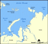
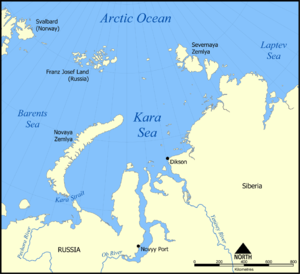
The
Kara Sea is part of the
Arctic OceanThe Arctic Ocean, located in the Northern Hemisphere and mostly in the Arctic north polar region, is the smallest and shallowest of the world's five major oceanic divisions...
north of
SiberiaSiberia is an extensive region constituting almost all of Northern Asia. Comprising the central and eastern portion of the Russian Federation, it was part of the Soviet Union from its beginning, as its predecessor states, the Tsardom of Russia and the Russian Empire, conquered it during the 16th...
. It is separated from the
Barents SeaThe Barents Sea is a marginal sea of the Arctic Ocean, located north of Norway and Russia. Known in the Middle Ages as the Murman Sea, the sea takes its current name from the Dutch navigator Willem Barents...
to the west by the
Kara StraitThe Kara Strait or Kara Gates is a 56 km wide channel of water between the southern end of Novaya Zemlya and the northern tip of Vaygach Island...
and
Novaya ZemlyaNovaya Zemlya , also known in Dutch as Nova Zembla and in Norwegian as , is an archipelago in the Arctic Ocean in the north of Russia and the extreme northeast of Europe, the easternmost point of Europe lying at Cape Flissingsky on the northern island...
, and the
Laptev SeaThe Laptev Sea is a marginal sea of the Arctic Ocean. It is located between the northern coast of Siberia, the Taimyr Peninsula, Severnaya Zemlya and the New Siberian Islands. Its northern boundary passes from the Arctic Cape to a point with co-ordinates of 79°N and 139°E, and ends at the Anisiy...
to the east by the
Severnaya ZemlyaSevernaya Zemlya is an archipelago in the Russian high Arctic at around . It is located off mainland Siberia's Taymyr Peninsula across the Vilkitsky Strait...
.
The Kara Sea's northern limit is marked geographically by a line running from
Cape KohlsaatCape Kohlsaat is a point on the eastern shore of Graham Bell Island, the easternmost island of Franz Josef Land, Russia. It is also the easternmost limit of the Franz Josef Archipelago....
in
Graham Bell IslandGraham Bell Island is an island located at in the Franz Josef Archipelago, Russia.Graham Bell Island is one of the largest islands of the group and it is partly glacierized. Its highest point is 509 m....
,
Franz Josef LandFranz Josef Land, Franz Joseph Land, or Francis Joseph's Land is an archipelago located in the far north of Russia. It is found in the Arctic Ocean north of Novaya Zemlya and east of Svalbard, and is administered by Arkhangelsk Oblast. Franz Josef Land consists of 191 ice-covered islands with a...
, to Cape Molotov (Arctic Cape), the northernmost point of
Komsomolets IslandKomsomolets Island is the northernmost island of the Severnaya Zemlya group in the Russian Arctic, and the third largest island in the group. It is the 82nd largest island on earth....
in
Severnaya ZemlyaSevernaya Zemlya is an archipelago in the Russian high Arctic at around . It is located off mainland Siberia's Taymyr Peninsula across the Vilkitsky Strait...
.
The Kara Sea is roughly 1,450 kilometres long and 970 kilometres wide with an area of around 880,000 km² and a mean depth of 110 metres (360.9 ft).
Compared to the Barents Sea, which receives relatively warm currents from the
AtlanticThe Atlantic Ocean is the second-largest of the world's oceanic divisions. With a total area of about , it covers approximately 20% of the Earth's surface and about 26% of its water surface area...
, the Kara Sea is much colder, remaining frozen for over nine months a year.
The Kara receives a large amount of
freshwaterFresh water is naturally occurring water on the Earth's surface in ice sheets, ice caps, glaciers, bogs, ponds, lakes, rivers and streams, and underground as groundwater in aquifers and underground streams. Fresh water is generally characterized by having low concentrations of dissolved salts and...
from the
ObThe Ob River , also Obi, is a major river in western Siberia, Russia and is the world's seventh longest river. It is the westernmost of the three great Siberian rivers that flow into the Arctic Ocean .The Gulf of Ob is the world's longest estuary.-Names:The Ob is known to the Khanty people as the...
,
YeniseiYenisei , also written as Yenisey, is the largest river system flowing to the Arctic Ocean. It is the central of the three great Siberian rivers that flow into the Arctic Ocean...
,
PyasinaPyasina River is a river in Krasnoyarsk Krai, Russia. The length of the river is . The area of its basin is 182,000 km². The Pyasina River originates in the Lake Pyasino and flows into the Pyasino Gulf of the Kara Sea. There are more than 60,000 lakes in the basin of the Pyasina covering...
, and Taimyra rivers, so its salinity is
variableVariable may refer to:* Variable , a logical set of attributes* Variable , a symbol that represents a quantity in an algebraic expression....
.
Its main ports are
Novy PortNovy Port is a settlement in Yamalo-Nenets Autonomous Okrug, Russia, located on the mouth of the Ob River. Population: 1,790.Along with Dikson, it is the main port on the Kara Sea...
and
DiksonDikson is an urban locality in Taymyrsky Dolgano-Nenetsky District of Krasnoyarsk Krai, Russia. Population: Dikson is the northernmost port in Russia and one of the northernmost settlements in the world. It is located so far north that one may experience complete darkness with no civil twilight...
and it is important as a
fishingFishing is the activity of trying to catch wild fish. Fish are normally caught in the wild. Techniques for catching fish include hand gathering, spearing, netting, angling and trapping....
ground although the sea is ice-bound for all but two months of the year. Significant discoveries of
petroleumPetroleum or crude oil is a naturally occurring, flammable liquid consisting of a complex mixture of hydrocarbons of various molecular weights and other liquid organic compounds, that are found in geologic formations beneath the Earth's surface. Petroleum is recovered mostly through oil drilling...
and
natural gasNatural gas is a naturally occurring gas mixture consisting primarily of methane, typically with 0–20% higher hydrocarbons . It is found associated with other hydrocarbon fuel, in coal beds, as methane clathrates, and is an important fuel source and a major feedstock for fertilizers.Most natural...
, an extension of the West Siberian Oil Basin, have been made but have not yet been developed.
Extent
The
International Hydrographic OrganizationThe International Hydrographic Organization is the inter-governmental organisation representing the hydrographic community. It enjoys observer status at the UN and is the recognised competent authority on hydrographic surveying and nautical charting...
defines the limits of the Kara Sea as follows:
On the West. The Eastern limit of Barentsz SeaThe Barents Sea is a marginal sea of the Arctic Ocean, located north of Norway and Russia. Known in the Middle Ages as the Murman Sea, the sea takes its current name from the Dutch navigator Willem Barents...
[Cape KohlsaatCape Kohlsaat is a point on the eastern shore of Graham Bell Island, the easternmost island of Franz Josef Land, Russia. It is also the easternmost limit of the Franz Josef Archipelago....
to Cape ZhelaniyaCape Zhelaniya . It lies at the northern end of Severny Island, in Novaya Zemlya, Russia. The whole area is a desolate place, exposed to bitter Arctic winters....
(Desire); West and Southwest coast of Novaya ZemlyaNovaya Zemlya , also known in Dutch as Nova Zembla and in Norwegian as , is an archipelago in the Arctic Ocean in the north of Russia and the extreme northeast of Europe, the easternmost point of Europe lying at Cape Flissingsky on the northern island...
to Cape Kussov Noss and thence to Western entrance Cape, Dolgaya Bay (70°15′N 58°25′E) on Vaigach IslandVaygach Island is an island in the Arctic Sea between the Pechora Sea and the Kara Sea.Vaygach Island is separated from the Yugorsky Peninsula in the mainland by the Yugorsky Strait and from Novaya Zemlya by the Kara Strait...
. Through Vaigach Island to Cape Greben; thence to Cape Belyi Noss on the mainland].
On the North. Cape Kohlsaat to Cape MolotovThe Arctic Cape is the northernmost point of the Komsomolets Island, which in turn is the northernmost island of the Russian Severnaya Zemlya archipelago in the Arctic Ocean. Its coordinates are approximately...
(81°16′N 93°43′E) (Northern extremity of Severnaya ZemlyaSevernaya Zemlya is an archipelago in the Russian high Arctic at around . It is located off mainland Siberia's Taymyr Peninsula across the Vilkitsky Strait...
on Komsomolets IslandKomsomolets Island is the northernmost island of the Severnaya Zemlya group in the Russian Arctic, and the third largest island in the group. It is the 82nd largest island on earth....
).
On the East. Komsomolets Island from Cape Molotov to South Eastern Cape; thence to Cape Vorochilov, Oktiabrskaya Revolutziya IslandOctober Revolution Island is the largest island of the Severnaya Zemlya group in the Russian Arctic....
to Cape Anuchin. Then to Cape Unslicht on Bolshevik IslandBolshevik Island is the southernmost island of the Severnaya Zemlya group in the Russian Arctic, and the second largest island in the group...
. Bolshevik Island to Cape YevgenovCape Yevgenov is an ice-covered cape midway along the northeast side of Krylov Peninsula, forming the west entrance to Lauritzen Bay, Antarctica. Photographed by U.S. Navy Operation Highjump , Soviet Antarctic Expedition , and ANARE . Named by Soviet Antarctic Expedition after Russian...
. Thence to Cape Pronchisthehev on the main land (see Russian chart No. 1484 of the year 1935).
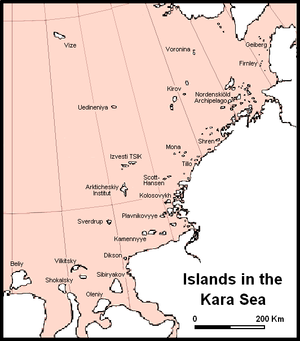
Islands
There are many islands and island groups in the Kara Sea. Unlike the other marginal seas of the Arctic, where most islands lie along the coasts, in the Kara Sea many islands, like the
Arkticheskiy Institut IslandsThe Arkticheskiy Institut Islands or Arctic Institute Islands is a compact archipelago of narrow islands covered with tundra vegetation. The islands are located in the Kara Sea, about north of the coast of Siberia, and just south of the nearest island group, the Izvesti Tsik Islands.The distance...
, the Izvesti Tsik Islands, the
Kirov IslandsThe Kirov Islands or Sergey Kirov Islands , also known as Kerova Islands, is an archipelago of small islands covered with tundra vegetation...
, Uedineniya or Lonely Island,
Vize IslandVize Island or Wiese Island is an isolated island located in the Arctic Ocean at the northern end of the Kara Sea, roughly midway between Franz Josef Land and Severnaya Zemlya, its latitude is 79° 30' N and its longitude 76° 54' E...
, and
Voronina IslandVoronina Island or Voronina Islands is an isolated two-island group composed of a larger island and a narrow island on its northern side separated by a 3 km wide sound.The main Voronina Island is about 9 km long and 6 km wide and is covered with tundra vegetation and ice...
are located in the open sea of its central regions.
The largest group in the Kara Sea is by far the
Nordenskiöld ArchipelagoThe Nordenskiöld Archipelago or Nordenskjold Archipelago is a very large and complex cluster of islands in the eastern region of the Kara Sea. Its eastern limit lies west of the Taymyr Peninsula....
, with five large subgroups and over ninety islands. Other important islands in the Kara Sea are
Bely IslandBely Island is a relatively large island in the Kara Sea off the tip of the Yamal Peninsula, Siberia, Russia.Bely Island covers an area of . It is covered by tundra, but some dwarf shrubs also grow on this island...
, Dikson Island,
Taymyr IslandTaymyr Island, Russian: Остров Таймыр , is a large island in the coast of the Kara Sea. Its length is and its average width about . This island is located west of the Taymyr Gulf in an area of skerries right off the western coast of the Taymyr Peninsula...
, the
Kamennyye IslandsThe Kamennyye Islands or Kammennyy Islands is a group islands covered with tundra vegetation. It is located in the Kara Sea, off the coast of Siberia, west of the mouths of river Pyasina.The main islands are :...
and Oleni Island.
History
The Kara Sea was formerly known as
Oceanus Scythicus or
Mare Glaciale and it appears with these names in old 16th century maps. Since it is closed by ice most of the year it remained largely unexplored until the late nineteenth century.
In 1556 Stephen Borough sailed in the
Searchthrift to try to reach the
Ob RiverThe Ob River , also Obi, is a major river in western Siberia, Russia and is the world's seventh longest river. It is the westernmost of the three great Siberian rivers that flow into the Arctic Ocean .The Gulf of Ob is the world's longest estuary.-Names:The Ob is known to the Khanty people as the...
, but he was stopped by ice and fog at the entrance to the Kara Sea. Not until 1580 did another English expedition, under Arthur Pet and Charles Jackman, attempt its passage. They too failed to penetrate it, and
EnglandEngland is a country that is part of the United Kingdom. It shares land borders with Scotland to the north and Wales to the west; the Irish Sea is to the north west, the Celtic Sea to the south west, with the North Sea to the east and the English Channel to the south separating it from continental...
lost interest in searching for the Northeast Passage.
In 1736-1737
RussiaRussia or , officially known as both Russia and the Russian Federation , is a country in northern Eurasia. It is a federal semi-presidential republic, comprising 83 federal subjects...
n Admiral
Stepan MalyginStepan Gavrilovich Malygin was a Russian Arctic explorer.In 1711–1717, Stepan Malygin was a student at the Moscow School of Mathematical and Navigational Sciences. After his graduation, Malygin began his career as a naval cadet and was then promoted to the rank of lieutenant four years later...
undertook a voyage from
Dolgiy IslandDolgy Island is an island in the Pechora Sea, east of the Khaypudyr Bay. Long and narrow, this island is in length, with an average width of...
in the
Barents SeaThe Barents Sea is a marginal sea of the Arctic Ocean, located north of Norway and Russia. Known in the Middle Ages as the Murman Sea, the sea takes its current name from the Dutch navigator Willem Barents...
. The two ships in this early expedition were the
Perviy, under Malygin's command and the
Vtoroy under Captain A. Skuratov. After entering the little-explored Kara Sea, they sailed to the mouth of the
Ob RiverThe Gulf of Ob is a gigantic bay of the Arctic Ocean, located in Northern Russia at the head the mouth of the Ob River....
. Malygin took careful observations of these hitherto almost unknown areas of the Russian Arctic coastline. With this knowledge he was able to draw the first somewhat accurate map of the Arctic shores between the
Pechora RiverThe Pechora River is a river in northwest Russia which flows north into the Arctic Ocean on the west side of the Ural Mountains. It lies mostly in the Komi Republic but the northernmost part crosses the Nenets Autonomous Okrug. It is 1,809 km long and its basin is 322,000 square kilometers...
and the
Ob RiverThe Ob River , also Obi, is a major river in western Siberia, Russia and is the world's seventh longest river. It is the westernmost of the three great Siberian rivers that flow into the Arctic Ocean .The Gulf of Ob is the world's longest estuary.-Names:The Ob is known to the Khanty people as the...
.
In 1878, Swedish explorer
Adolf Erik NordenskiöldFreiherr Nils Adolf Erik Nordenskiöld , also known as A. E. Nordenskioeld was a Finnish baron, geologist, mineralogist and arctic explorer of Finnish-Swedish origin. He was a member of the prominent Finland-Swedish Nordenskiöld family of scientists...
on ship
Vega sailed across the Kara Sea from Göteborg, along the coast of Siberia, and despite the ice packs, got to 180° longitude by early September. Frozen in for the winter in the
Chukchi SeaChukchi Sea is a marginal sea of the Arctic Ocean. It is bounded on the west by the De Long Strait, off Wrangel Island, and in the east by Point Barrow, Alaska, beyond which lies the Beaufort Sea. The Bering Strait forms its southernmost limit and connects it to the Bering Sea and the Pacific...
, Nordenskiöld waited and bartered with the local
ChukchiThe Chukchi, or Chukchee , ) are an indigenous people inhabiting the Chukchi Peninsula and the shores of the Chukchi Sea and the Bering Sea region of the Arctic Ocean within the Russian Federation. They speak the Chukchi language...
people. The following July, the Vega was freed from the ice, and continued to
Yokohamais the capital city of Kanagawa Prefecture and the second largest city in Japan by population after Tokyo and most populous municipality of Japan. It lies on Tokyo Bay, south of Tokyo, in the Kantō region of the main island of Honshu...
, Japan. He became the first to force the Northeast Passage. The largest group of islands in the Kara Sea, the
Nordenskiöld ArchipelagoThe Nordenskiöld Archipelago or Nordenskjold Archipelago is a very large and complex cluster of islands in the eastern region of the Kara Sea. Its eastern limit lies west of the Taymyr Peninsula....
, has been named in his honour.
1912 was a tragic year for Russian explorers in the Kara Sea. In that fateful year unbroken consolidated ice blocked the way for the
Northern Sea RouteThe Northern Sea Route is a shipping lane officially defined by Russian legislation from the Atlantic Ocean to the Pacific Ocean specifically running along the Russian Arctic coast from Murmansk on the Barents Sea, along Siberia, to the Bering Strait and Far East. The entire route lies in Arctic...
and three expeditions that had to cross the Kara Sea became trapped and failed:
SedovGeorgy Yakovlevich Sedov was a Russian Arctic explorer.Born in the village of Krivaya Kosa of Taganrog district in a fisherman's family. In 1898, Sedov finished navigation courses in Rostov-on-Don and acquired the rank of long voyage navigator...
's on vessel
St. Foka,
BrusilovGeorgy Lvovich Brusilov or Hryhoriy Brusylov was a Ukrainian Russian naval officer of the Imperial Russian Navy and an Arctic explorer...
's on the
St. AnnaThe ship Svyataya Anna , named after Saint Anne, was the Philomel-class gunvessel HMS Newport launched in England in 1867. She was sold in 1881 and renamed Pandora II. She was purchased again in about 1890 and renamed Blencathra, taking part in expeditions to the north coast of Russia...
, and
RusanovVladimir Alexandrovich Rusanov was an experienced Russian geologist who specialized in the Arctic.In 1909–1911 V. A. Rusanov carried out explorations in Novaya Zemlya. He was helped by Tyko Vylka, his guide, who later became the Chairman of the Novaya Zemlya Soviet.In 1912 Rusanov had been...
's on the
Gercules. Georgy Sedov intended to reach Franz Josef Land on ship, leave a depot over there, and sledge to the pole. Due to the heavy ice the vessel could only reach
Novaya ZemlyaNovaya Zemlya , also known in Dutch as Nova Zembla and in Norwegian as , is an archipelago in the Arctic Ocean in the north of Russia and the extreme northeast of Europe, the easternmost point of Europe lying at Cape Flissingsky on the northern island...
the first summer and wintered in
Franz Josef LandFranz Josef Land, Franz Joseph Land, or Francis Joseph's Land is an archipelago located in the far north of Russia. It is found in the Arctic Ocean north of Novaya Zemlya and east of Svalbard, and is administered by Arkhangelsk Oblast. Franz Josef Land consists of 191 ice-covered islands with a...
. In February 1914 Sedov headed to the
North PoleThe North Pole, also known as the Geographic North Pole or Terrestrial North Pole, is, subject to the caveats explained below, defined as the point in the northern hemisphere where the Earth's axis of rotation meets its surface...
with two sailors and three sledges, but he fell ill and died on
Rudolf IslandFranz Josef Land, Franz Joseph Land, or Francis Joseph's Land is an archipelago located in the far north of Russia. It is found in the Arctic Ocean north of Novaya Zemlya and east of Svalbard, and is administered by Arkhangelsk Oblast. Franz Josef Land consists of 191 ice-covered islands with a...
.
Georgy BrusilovGeorgy Lvovich Brusilov or Hryhoriy Brusylov was a Ukrainian Russian naval officer of the Imperial Russian Navy and an Arctic explorer...
attempted to navigate the Northeast Passage, was trapped in the Kara Sea, and drifted northward for more than two years reaching latitude 83°17 N. Thirteen men, headed by
Valerian AlbanovValerian Ivanovich Albanov was a Russian navigator, best known for being one of only two survivors of the ill-fated Brusilov expedition of 1912.-Biography:...
, left the vessel and started across the ice to
Franz Josef LandFranz Josef Land, Franz Joseph Land, or Francis Joseph's Land is an archipelago located in the far north of Russia. It is found in the Arctic Ocean north of Novaya Zemlya and east of Svalbard, and is administered by Arkhangelsk Oblast. Franz Josef Land consists of 191 ice-covered islands with a...
, but only Albanov and one sailor (
Alexander KonradAlexander Eduardovich Konrad was a Russian sailor. Along with Valerian Albanov, he was one of the only two survivors, and the only surviving sailor of the ill-fated Brusilov expedition.-Biography:...
) survived after a gruesome three month ordeal. The survivors brought the ship log of
St. Anna, the map of her drift, and daily meteorological records, but the destiny of those who stayed onboard remains unknown.
In the same year the expedition of
Vladimir RusanovVladimir Alexandrovich Rusanov was an experienced Russian geologist who specialized in the Arctic.In 1909–1911 V. A. Rusanov carried out explorations in Novaya Zemlya. He was helped by Tyko Vylka, his guide, who later became the Chairman of the Novaya Zemlya Soviet.In 1912 Rusanov had been...
was lost in the Kara Sea. The prolonged absence of those three expeditions stirred public attention, and a few small rescue expeditions were launched, including
Jan NagórskiJan Nagórski , also known by his Russified name of Ivan Nagurski was a Polish engineer and pioneer of aviation, the first person to fly an airplane in the Arctic and the first aviator to perform a loop with a flying boat....
's five air flights over the sea and ice from the NW coast of
Novaya ZemlyaNovaya Zemlya , also known in Dutch as Nova Zembla and in Norwegian as , is an archipelago in the Arctic Ocean in the north of Russia and the extreme northeast of Europe, the easternmost point of Europe lying at Cape Flissingsky on the northern island...
.
After the Russian Revolution in 1917, the scale and scope of exploration of the Kara Sea increased greatly as part of the work of developing the Northern Sea Route. Polar stations, of which five already existed in 1917, increased in number, providing meteorologic, ice reconnaissance, and radio facilities. By 1932 there were 24 stations, by 1948 about 80, and by the 1970s more than 100. The use of icebreakers and, later, aircraft as platforms for scientific work was developed. In 1929 and 1930 the
Icebreaker SedovThe Sedov was a Soviet ice-breaker fitted with steam engines. She was originally the Newfoundland sealing steamer Beothic and was renamed after Russian Captain and Polar explorer Georgy Yakovlevich Sedov....
carried groups of scientists to
Severnaya ZemlyaSevernaya Zemlya is an archipelago in the Russian high Arctic at around . It is located off mainland Siberia's Taymyr Peninsula across the Vilkitsky Strait...
, the last major piece of unsurveyed territory in the Soviet Arctic; the archipelago was completely mapped under
Georgy UshakovGeorgy Alexeyevich Ushakov was a Soviet explorer of the Arctic, Doctor of Geographic Sciences ....
between 1930 and 1932.
Particularly worth noting are three cruises of the
Icebreaker SadkoIcebreaker Sadko was a Russian and Soviet icebreaker ship of 3,800 tonnes displacement. She was named after Sadko, a hero of a Russian bylina....
, which went farther north than most; in 1935 and 1936 the last unexplored areas in the northern Kara Sea were examined and small and elusive
Ushakov IslandUshakov Island is an isolated island located in the Arctic Ocean, midway between Franz Josef Land and Severnaya Zemlya, at the northern limit of the Kara Sea. Its latitude is 80° 48' N and its longitude 79° 29' E....
was discovered.
In the summer of 1942, German
KriegsmarineThe Kriegsmarine was the name of the German Navy during the Nazi regime . It superseded the Kaiserliche Marine of World War I and the post-war Reichsmarine. The Kriegsmarine was one of three official branches of the Wehrmacht, the unified armed forces of Nazi Germany.The Kriegsmarine grew rapidly...
warships and submarines entered the Kara Sea in order to destroy as many Russian vessels as possible. This naval campaign was named "
Operation WunderlandOperation Wunderland was a large-scale operation undertaken in summer 1942 by the Kriegsmarine during World War II in the waters of the Northern Sea Route close to the Arctic Ocean...
". Its success was limited by the presence of ice floes, as well as bad weather and fog. These effectively protected the Soviet ships, preventing the damage that could have been inflicted on the
Soviet fleetThe Soviet Navy was the naval arm of the Soviet Armed Forces. Often referred to as the Red Fleet, the Soviet Navy would have played an instrumental role in a Warsaw Pact war with NATO, where it would have attempted to prevent naval convoys from bringing reinforcements across the Atlantic Ocean...
under fair weather conditions.
In October 2010, the Russian government awarded a license to Russian oil company
RosneftRosneft is an integrated oil company majority owned by the Government of Russia. Rosneft is headquartered in Moscow’s Balchug district near the Kremlin, across the Moskva river...
for developing the
East-Prinovozemelsky oil and gas structureThe East-Prinovozemelsky field is a gigantic undeveloped Arctic oil and gas field located on the continental shelf of Russia in the South Kara Sea between the Yamal Peninsula and Novaya Zemlya island.-History:The field is divided into three license blocks: EPNZ-1, EPNZ2, and...
in the Kara Sea.
Nuclear Dumping
There is concern about
radioactive contaminationRadioactive contamination, also called radiological contamination, is radioactive substances on surfaces, or within solids, liquids or gases , where their presence is unintended or undesirable, or the process giving rise to their presence in such places...
from nuclear waste the former
Soviet UnionThe Soviet Union , officially the Union of Soviet Socialist Republics , was a constitutionally socialist state that existed in Eurasia between 1922 and 1991....
dumped in the sea and the effect this will have on the marine environment. According to an official "White Paper" report compiled and released by the Russian government in March 1993, the Soviet Union dumped six
nuclear submarineA nuclear submarine is a submarine powered by a nuclear reactor . The performance advantages of nuclear submarines over "conventional" submarines are considerable: nuclear propulsion, being completely independent of air, frees the submarine from the need to surface frequently, as is necessary for...
reactors and ten nuclear reactors into the Kara Sea between 1965-1988. Solid high- and low-level wastes unloaded from Northern Fleet nuclear submarines during reactor refuelings, were dumped in the Kara Sea, mainly in the shallow fjords of Novaya Zemlya, where the depths of the dumping sites range from 12 to 135 meters, and in the Novaya Zemlya Trough at depths of up to 380 meters. Liquid low-level wastes were released in the open Barents and Kara Seas. A subsequent appraisal by the
International Atomic Energy AgencyThe International Atomic Energy Agency is an international organization that seeks to promote the peaceful use of nuclear energy, and to inhibit its use for any military purpose, including nuclear weapons. The IAEA was established as an autonomous organization on 29 July 1957...
showed that releases are low and localized from the 16 naval reactors (reported by the IAEA as having come from seven submarines and the icebreaker "Lenin") which were dumped at five sites in the Kara Sea. Most of the dumped reactors had suffered an accident.
Nature Reserve
The
Great Arctic State Nature ReserveThe Great Arctic State Nature Reserve is a nature reserve in Krasnoyarsk Krai, Russia...
– the largest
nature reserveA nature reserve is a protected area of importance for wildlife, flora, fauna or features of geological or other special interest, which is reserved and managed for conservation and to provide special opportunities for study or research...
of Russia and the whole Europe - was founded on May 11, 1993 by Resolution No.431 of the Government of the Russian Federation (RF). The Kara Sea Islands section (4,000 km²) of the Great Arctic Nature Reserve includes: the
Sergei Kirov ArchipelagoThe Kirov Islands or Sergey Kirov Islands , also known as Kerova Islands, is an archipelago of small islands covered with tundra vegetation...
, the
Voronina IslandVoronina Island or Voronina Islands is an isolated two-island group composed of a larger island and a narrow island on its northern side separated by a 3 km wide sound.The main Voronina Island is about 9 km long and 6 km wide and is covered with tundra vegetation and ice...
, the
Izvestiy TSIK IslandsThe Izvestiy TSIK Islands or Izvesti Tsik Islands , also known as Izvestia Islands, is an archipelago composed of two large and two small islands covered with tundra vegetation, shingle and ice...
, the Arctic Institute Islands, the Svordrup Island, the Uedineniya Island and a number of smaller islands. This section represents rather fully the natural and biological diversity of Arctic sea islands of the eastern part of the Kara Sea.
See also
- Northern Sea Route
The Northern Sea Route is a shipping lane officially defined by Russian legislation from the Atlantic Ocean to the Pacific Ocean specifically running along the Russian Arctic coast from Murmansk on the Barents Sea, along Siberia, to the Bering Strait and Far East. The entire route lies in Arctic...
- Adolf Erik Nordenskiöld
Freiherr Nils Adolf Erik Nordenskiöld , also known as A. E. Nordenskioeld was a Finnish baron, geologist, mineralogist and arctic explorer of Finnish-Swedish origin. He was a member of the prominent Finland-Swedish Nordenskiöld family of scientists...
- Valerian Albanov
Valerian Ivanovich Albanov was a Russian navigator, best known for being one of only two survivors of the ill-fated Brusilov expedition of 1912.-Biography:...
- Boris Vilkitsky
Boris Andreyevich Vilkitsky was a Russian hydrographer and surveyor. He was the son of Andrey Ippolitovich Vilkitsky....
External links
The source of this article is
wikipedia, the free encyclopedia. The text of this article is licensed under the
GFDL.