

Laptev Sea
Encyclopedia
The Laptev Sea is a marginal sea
of the Arctic Ocean
. It is located between the northern coast of Siberia
, the Taimyr Peninsula, Severnaya Zemlya
and the New Siberian Islands
. Its northern boundary passes from the Arctic Cape
to a point with co-ordinates of 79°N
and 139°E
, and ends at the Anisiy Cape. The Kara Sea
lies to the west, the East Siberian Sea
to the east.
The sea is named after the Russian explorers Dmitry Laptev
and Khariton Laptev
; formerly, it had been known under various names, the last being Nordenskjold Sea , after explorer Adolf Erik Nordenskiöld
. The sea has a severe climate with temperatures below 0 °C (32 °F) over more than 9 months per year, low water salinity
, scarcity of flora, fauna and human population, and low depths (mostly less than 50 meters). It is frozen most of the time, though generally clear in August and September.
The sea shores were inhabited for thousands of years by indigenous tribes of Yukaghirs and then Evens
and Evenks
, which were engaged in fishing, hunting and reindeer husbandry. They were then settled by Yakuts
and later by Russians. Russian explorations of the area started in the 17th century. They came from the south via several large rivers which empty into the sea, such as the prominent Lena River
, the Khatanga
, the Anabar
, the Olenyok
, the Omoloy
and the Yana
. The sea contains several dozen islands, many of which contain well-preserved mammoth
remains.
Major human activities in the area are mining and navigation on the Northern Sea Route
; fishing and hunting are practised but have no commercial significance. The largest settlement
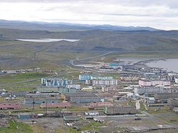
and port is Tiksi
.
defines the limits of the Laptev Sea as follows:
, with its great delta
, is the biggest river flowing into the Laptev Sea, and is the second largest river in the Russian Arctic after Yenisei. Other important rivers include the Khatanga
, the Anabar
, the Olenyok or Olenek
, the Omoloy
and the Yana
.
The sea shores are winding and form gulfs and bays of various sizes. The coastal landscape is also diverse, with small mountains near the sea in places. The main gulfs of the Laptev Sea coast are the Khatanga Gulf
, the Olenyok Gulf
, the Buor-Khaya Gulf
and the Yana Bay
.
There are several dozens of islands with the total area of 3784 km² (1,461 sq mi), mostly in the western part of the sea and in the river deltas. Storms and currents due to the ice thawing significantly erode the islands, so the Semenovsky and Vasilievsky islands (74°12"N, 133°E) which were discovered in 1815 have already disappeared. The most significant groups of islands are Severnaya Zemlya
, Komsomolskaya Pravda
, Vilkitsky and Faddey
, and the largest individual islands are Bolshoy Begichev
(1764 км²), Belkovsky
(500 км²), Maly Taymyr
(250 км²), Stolbovoy
(170 км²) , Starokadomsky
(110 км²), and
Peschanyy
(17 km²). (see Islands of the Laptev Sea)
More than half of the sea (53%) rests on a continental shelf
with the average depths below 50 metres (164 ft), and the areas south from 76°N are shallower than 25 m. In the northern part, the sea bottom sharply drops to the ocean floor with the depth of the order of 1 kilometre (0.621372736649807 mi) (22% of the sea area). There it is covered with silt
, which is mixed with ice in the shallow areas.
and midnight sun
last about 3 months per year on the south and 5 months on the north. Air temperatures stay below 0 °С 11 months a year on the north and 9 months on the south. The average temperature in January (coldest month) varies across the sea between -31 C and -34 C and the minimum is -50 C. In July, the temperature rises to 0 °С (maximum 4 °С) in the north and to 5 °С (maximum 10 °С) in the south, however, it may reach 22–24 °С on the coast in August. The maximum of 32.7 °C (90.9 °F) was recorded in Tiksi
. Strong winds, blizzards and snow storms are common in winter. Snow falls even in summer and is alternating with fogs.
The winds blow from south and south-west in winter with the average speed of 8 m/s which subsides toward the spring. In summer, they change direction to the northerly, and their speed is 3–4 m/s. Relatively weak winds result in low convection in the surface waters, which occurs only to the depth of 5–10 meters.
. With an average outflow of 483,000 km2 per year over the period 1979–1995, it contributes more sea ice than the Barents Sea
, Kara Sea
, East Siberian Sea
and Chukchi Sea
combined. Over this period, the annual outflow fluctuated between 251,000 km2 in 1984–85 and 732,000 km2 in 1988–89. The sea exports substantial amounts of sea ice in all months but July, August and September.
Ice formation starts in September on the north and October on the south. It results in a large continuous sheet of ice, with the thickness up to 2 metres (6.6 ft) in the south-eastern part of the sea as well as near the coast. The coastal sheet ends at the water depth of 20–25 m which occurs at several hundred kilometers from the shore, thus this coastal ice covers some 30% of the sea area. Ice is drifting north to this coastal band, and several polynya
s are formed by the warm south winds around there. They have various names, such as the Great Siberian Polynya, and can stretch over many hundreds kilometers. The ice sheet starts melting in late May-early June, creating fragmented ice agglomerates on the north-west and south-east and often revealing remains of the mammoths. The ice formation varies from year to year, with the sea either clear or completely covered with ice.
. The deeper layer is colder at about −0.8 °С. In summer, the surface layer in the ice-free zones warms up by the sun up to 8–10 °С in the bays and 2–3 °С in the open sea, and remains close to 0 °С under ice. The water salinity
is significantly affected by the thawing of ice and river runoff. The latter amounts to about 730 km3 and would form a 135 cm freshwater layer over the entire sea; it is the second largest in the world after the Kara sea
. The salinity values vary in winter from 20–25‰ (parts per thousand) in the south-east to 34‰ in the northern parts of the sea; it decreases in summer to 5–10‰ and 30–32‰ respectively.
Most of the river runoff (about 70% or 515 km3/year) is contributed by the Lena River. Other major contributions are from Khatanga (more than 100 km3), Olenyok (35 km3), Yana (>30 km3) and Anabar (20 km3), with other rivers contributing about 20 km3. Owing to the ice melting seasoning, About 90% of the annual runoff occurs between June and September with 35–40% in August alone, whereas January contributes only 5%.
Sea currents form a cyclone consisting of the southward stream near Severnaya Zemlya which reaches the continental coast and flows along it from west to east. It is then amplified by the Lena River flow and diverts to the north and north-west toward the Arctic Ocean. A small part of the cyclone leaks through the Sannikov Strait
to the East Siberian Sea. The cyclone has a speed of 2 cm/s which is decreasing toward the center. The center of the cyclone drifts with time that slightly alters the flow character.
The tides are mostly semi-diurnal (rise twice a day), with the average amplitude of 0.5 metres (1.6 ft). In the Khatanga Gulf
it may reach 2 m because of the funnel-like shape of the gulf. This tidal wave is then noticeable up to the unusually long distance of 500 km up to the Khatanga River
– the tidal wave is damped at much shorter distance in other rivers of the Laptev Sea.
The seasonal variations of the sea level are relatively small – the sea level rises up to 40 cm (15.7 in) in summer near the river deltas and lowers in winter. Wind-induced changes are observed all through the year, but are more frequent in autumn when the winds are strong and steady. In general, the sea level rises with northern and lowers with southern winds, but depending on the area, the maximum amplitude is observed for a specific wind direction (e.g. western and north-western in the south-eastern part of the sea). They average amplitudes are 1–2 m and may exceed 2.5 metres (8.2 ft) near Tiksi.
Owing to the weak winds and shallow waters, the sea is relatively calm with the waves typically within 1 metres (3.3 ft). In July–August waves up to 4–5 m are observed near the sea center, and they may reach 6 metres (19.7 ft) in autumn.
and Evenks
around the 2nd century and later, between 9th and 15th centuries, by much more numerous Yakuts
. All those tribes moved north from the Baikal Lake area avoiding confrontations with Mongols. Whereas they all practiced shamanism
, they spoke different languages.
Russians started exploring the Laptev Sea coast and the nearby islands some time in the 17th century, going through the rivers emptying into the sea. Many early explorations were likely unreported, as indicated by finding of graves on some islands by their official discoverers. In 1629, Siberian Cossacks
went through the Lena River
and reached its delta. They left a note that the river flows into a sea. In 1633, another group reached the delta of Olenyok.
By 1712, Yakov Permyakov
and Merkury Vagin
explored the eastern part of the Laptev Sea and discovered Bolshoy Lyakhovsky Island. However, they were killed on the way back from their expedition by mutineering team members. In 1770, the merchant Ivan Lyakhov
revisited the islands and then asked a government permission to commercially develop their ivory resources. Catherine II
granted the permission and named the islands after Lyakhov. While exploring the area in 1770s, Lyakhov described several other islands, including Kotelny, which he named so after a large kettle ( – kotel) left there by previous visitors. He also established first permanent settlements on those islands.
In 1735, Russian explorer of Siberia Vasili Pronchishchev
sailed from Yakutsk
down the Lena River
on his sloop Yakutsk. He explored the eastern coast of the Lena delta, and stopped for wintering at the mouth of the Olenyok River
. Unfortunately many members of his crew fell ill and died, mainly owing to scurvy
. Despite these difficulties, in 1736, he reached the eastern shore of the Taymyr Peninsula
and went north surveying its coastline. Pronchishchev and his wife succumbed to scurvy and died on the way back. Maria Pronchishcheva Bay
in the Laptev Sea is named after the wife of Pronchishchev.
During the 1739–1742 Great Northern Expedition
, Russian Arctic explorer and Vice Admiral Dmitry Laptev
described the sea coastline from the mouth of the Lena River, along the Buor-Khaya and Yana gulfs, to the strait that bears his name, Dmitry Laptev Strait. As part of the same expedition, Dmitry's cousin Khariton Laptev
's led a party that surveyed the coast of the Taimyr Peninsula starting from the mouth of the Khatanga River.
 Detailed mapping of the coast of the Laptev Sea and New Siberian Islands was performed by Pyotr Anjou, who in 1821–1823 traveled some 14000 km (8,699.2 mi) over the region on sledges and small boats, searching for the Sannikov Land
and demonstrating that large-scale coastal observations can be performed without ships. Anzhu Islands
(the northern part of New Siberian Islands) were named after him. In 1875, Adolf Erik Nordenskiöld
was the first to travel across the whole sea on a steamship Vega.
In 1892–1894, and again in 1900–1902, Baron Eduard Von Toll explored the Laptev Sea in the course of two separate expeditions. On the ship Zarya
, Toll carried out geological and geographical surveys in the area on behalf of the Russian Imperial Academy of Sciences. In his last expedition Toll disappeared off the New Siberian Islands under mysterious circumstances. Toll noted sizable and economically significant accumulations of perfectly preserved fossil
ivory
in recent beaches, drainage areas, river terraces and river beds within the New Siberian Islands. The later scientific studies demonstrated that the ivory accumulated over a period of some 200,000 years.
and Khariton Laptev
who first mapped its shores in 1735–1740.
 Both flora and fauna are scarce owing to the harsh climate. Vegetation of the sea is mostly represented by diatom
s, with more than 100 species. In comparison, the number of green algae
, blue-green algae and flagellate
species is about 10 each. The phytoplankton
is characteristic of brackish waters and has a total concentration of about 0.2 mg/L. There are about 30 species of zooplankton
with the concentration reaching 0.467 mg/L. The coastal flora mainly consists of mosses and lichens and a few flowering plants including arctic poppy (Papaver radicatum), Saxifraga, Draba
and small populations of polar (Salix polaris) and creeping (Salicaceae
) willows. Rare vascular plants include species of Cerastium
and Saxifraga. Non-vascular plants include the moss
genera Detrichum, Dicranum
, Pogonatum, Sanionia, Bryum, Orthothecium and Tortura, as well as the lichen
genera Cetraria
, Thamnolia
, Cornicularia
, Lecidea
, Ochrolechia
and Parmelia
.
Permanent mammal species include ringed seal
(Phoca hispida), bearded seal
(Erignathus barbatus), Harp Seal
(Pagophilus groenlandicus), walrus
(Odobenus rosmarus), collared lemming
(Dicrostonyx torquatus), Arctic fox
(Alopex lagopus), reindeer
(Rangifer tarandus) wolf (Canis lupus), ermine
(Mustela erminea), Arctic hare
(Lepus timidus) and polar bear
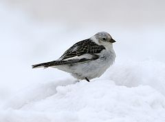
(Ursus maritimus), whereas beluga whales (Delphinapterus leucas) visit the region seasonally. The walrus of the Laptev Sea is sometimes distinguished as a separate subspecies Odobenus rosmarus laptevi, though this attribution is questioned. There are several dozens species of birds. Some belong to permanent (tundra) species, such as snow bunting
(Plectrophenax nivalis), purple sandpiper
(Calidris maritima), Snowy Owl
(Bubo scandiacus) and brent goose
and other make large colonies on the islands and sea shores. The latter include little auk
(Alle alle), Black-legged Kittiwake
(Rissa tridactyla), black guillemot
(Cepphus grylle), ivory gull
(Pagophila eburnea), uria
, charadriiformes
and glaucous gull
(Larus hyperboreus). Amont other bird species are skua
, sterna
, Northern Fulmar
, (Fulmarus glacialis), Ivory Gull
(Pagophila eburnea), Glaucous Gull
(Larus hyperboreus), Ross's Gull
(Rhodostethia rosea), Long-tailed Duck
(Clangula hyemalis), eider
, loon
and Willow Grouse
(Lagopus lagopus). There are 39 fish species, mostly typical of braskish environment; the major ones are grayling
and Coregonus
(whitefishes), such as muksun
(Coregonus muksun), broad whitefish
(Coregonus nasus) and omul
(Coregonus autumnalis). Also common are sardine
, Arctic cisco
, Bering cisco
, polar smelt
, saffron cod
, polar cod
, flounder
and arctic char
and inconnu
.
In 1985, the Ust-Lena Nature Reserve was established in the delta (from – ust, meaning delta) of the Lena River with an area of 14,300 km². In 1886, New Siberian Islands were included into the reserve. The reserve hosts numerous plants (402 species), fishes (32 species), birds (109 species) and mammals (33 species).
(Taymyrsky Dolgano-Nenetsky District
) of Russia on the west. The coastal settlements are few and small, with the typical population of a few hundred or less. The only exception is Tiksi
(population 5,873), which is the administrative center of the Bulunsky District.
 Fishery and hunting have relatively small volume and are mostly concentrated in the river deltas. Data are available for the Khatanga Bay and deltas of the Lena and Yana rivers from 1981 to 1991 which translate into about 3,000 tonnes of fish annually. Extrapolated, they give the following annual estimates (in thousand tonnes) by species: sardine
(1.2), Arctic cisco
(2.0), Bering cisco
(2.7), broad whitefish
(2.6), Muksun
(2.4) and others (3.6). Hunting sea mammals is only practices by native people. In particular walrus hunting is only allowed by scientific expeditions and local tribes for subsistence.
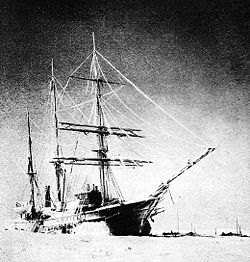
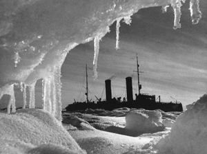
Despite freezing, navigation is a major human activity on the Laptev Sea with the major port in Tiksi
. During Soviet times, the Laptev Sea coastal areas experienced a limited boom owing to the first icebreaker convoys plying the Northern Sea Route
and the creation of the Chief Directorate of the Northern Sea Route
. The route was difficult even for icebreakers – so Lenin
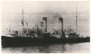
(pictured) and her convoy of five ships were trapped in ice in the Laptev Sea around September 1937. They spent enforced winter there and were rescued by another icebreaker Krasin
in August 1938. The major transported goods were timber, fur and construction materials. Tiksi had an active airport, and Nordvik
harbor further west was "a growing town," though it was closed in mid 1940s.
 After the break-up of the Soviet Union commercial navigation in the Siberian Arctic went into decline in the 1990s. More or less regular shipping is to be found only from Murmansk
to Dudinka
in the west and between Vladivostok
and Pevek
in the east. Ports between Dudinka and Pevek see next to no shipping at all. Logashkino
was abandoned in 1998 and is now a ghost town
.
. In order to explore them in the extreme Arctic conditions, a Gulag
penal labor camp
was established in Nordvik. Drilling revealed only small, shallow oil pockets in connection with salt structures with little commercial significance. However the salt was extracted on a large scale by means of forced laborers in a penal colony. From the 1930s onwards Nordvik became an important source of salt supply for the northern fisheries. Although the original prospects for oil at Nordvik did not materialize, experience was gained in the exploration for hydrocarbons within the continuous permafrost zones. This experience proved invaluable in the later exploration and exploitation of the massive oil and gas fields of Western Siberia
. The penal colony was closed and its traces erased in mid 1940s right before Americans arrived in Nordvik as allies of the Soviet Union
.
In the Anabar District of Sakha, in the village of Mayat there is one of the northernmost diamond mines. There are also tin and gold mines in the Ust-Yansky District.
agency. The program aims at long-term, systematic and thorough measurements of clouds, radiation, aerosols, surface energy fluxes and chemistry in the Arctic. It is based on four Arctic stations at one of the world's northernmost settlements
, namely Eureka
and Alert
in Canada (in particular, Alert is the northernmost permanently inhabited place on Earth, only 817 km (507.7 mi) from the North Pole), Tiksi in Russia, and Barrow
in Alaska.
of Tiksi. Occasional petrol spills occurred due to navigation and petrol mining. Another major contaminant is associated with floating and sunken wood in the sea, due to decades of rafting activities. As a result, the phenol concentration in the Laptev Sea is the highest over the Arctic waters.
Marginal sea
The term marginal sea has differing meanings. In one sense the term is equivalent to territorial waters. In another sense the term indicates a partially enclosed sea adjacent to or widely open to the open ocean, but bounded by submarine ridges...
of the Arctic Ocean
Arctic Ocean
The Arctic Ocean, located in the Northern Hemisphere and mostly in the Arctic north polar region, is the smallest and shallowest of the world's five major oceanic divisions...
. It is located between the northern coast of Siberia
Siberia
Siberia is an extensive region constituting almost all of Northern Asia. Comprising the central and eastern portion of the Russian Federation, it was part of the Soviet Union from its beginning, as its predecessor states, the Tsardom of Russia and the Russian Empire, conquered it during the 16th...
, the Taimyr Peninsula, Severnaya Zemlya
Severnaya Zemlya
Severnaya Zemlya is an archipelago in the Russian high Arctic at around . It is located off mainland Siberia's Taymyr Peninsula across the Vilkitsky Strait...
and the New Siberian Islands
New Siberian Islands
The New Siberian Islands are an archipelago, located to the North of the East Siberian coast between the Laptev Sea and the East Siberian Sea north of the Sakha Republic....
. Its northern boundary passes from the Arctic Cape
Arctic Cape
The Arctic Cape is the northernmost point of the Komsomolets Island, which in turn is the northernmost island of the Russian Severnaya Zemlya archipelago in the Arctic Ocean. Its coordinates are approximately...
to a point with co-ordinates of 79°N
79th parallel north
The 79th parallel north is a circle of latitude that is 79 degrees north of the Earth's equatorial plane, in the Arctic. It crosses the Atlantic Ocean, Europe, Asia, the Arctic Ocean and North America....
and 139°E
139th meridian east
The meridian 139° east of Greenwich is a line of longitude that extends from the North Pole across the Arctic Ocean, Asia, the Pacific Ocean, Australasia, the Indian Ocean, the Southern Ocean, and Antarctica to the South Pole....
, and ends at the Anisiy Cape. The Kara Sea
Kara Sea
The Kara Sea is part of the Arctic Ocean north of Siberia. It is separated from the Barents Sea to the west by the Kara Strait and Novaya Zemlya, and the Laptev Sea to the east by the Severnaya Zemlya....
lies to the west, the East Siberian Sea
East Siberian Sea
The East Siberian Sea is a marginal sea in the Arctic Ocean. It is located between the Arctic Cape to the north, the coast of Siberia to the south, the New Siberian Islands to the west and Cape Billings, close to Chukotka, and Wrangel Island to the east...
to the east.
The sea is named after the Russian explorers Dmitry Laptev
Dmitry Laptev
Dmitry Yakovlevich Laptev was a Russian Arctic explorer and Vice Admiral .Dmitry Laptev was born in the village of Bolotovo, near Velikie Luki, in 1701. Bolotovo was the estate of his father, Yakov Laptev...
and Khariton Laptev
Khariton Laptev
Khariton Prokofievich Laptev was a Russian naval officer and Arctic explorer.Khariton Laptev was born in a gentry family in the village of Pokarevo near Velikiye Luki , just a year before his cousin Dmitry Laptev was born in the nearby village of Bolotovo.Khariton Laptev started his career in the...
; formerly, it had been known under various names, the last being Nordenskjold Sea , after explorer Adolf Erik Nordenskiöld
Adolf Erik Nordenskiöld
Freiherr Nils Adolf Erik Nordenskiöld , also known as A. E. Nordenskioeld was a Finnish baron, geologist, mineralogist and arctic explorer of Finnish-Swedish origin. He was a member of the prominent Finland-Swedish Nordenskiöld family of scientists...
. The sea has a severe climate with temperatures below 0 °C (32 °F) over more than 9 months per year, low water salinity
Salinity
Salinity is the saltiness or dissolved salt content of a body of water. It is a general term used to describe the levels of different salts such as sodium chloride, magnesium and calcium sulfates, and bicarbonates...
, scarcity of flora, fauna and human population, and low depths (mostly less than 50 meters). It is frozen most of the time, though generally clear in August and September.
The sea shores were inhabited for thousands of years by indigenous tribes of Yukaghirs and then Evens
Evens
The Evens or Eveny are a people in Siberia and the Russian Far East. They live in some of the regions of the Magadan Oblast and Kamchatka Krai and northern parts of Sakha east of the Lena River. According to the 2002 census, there were 19,071 Evens in Russia...
and Evenks
Evenks
The Evenks are a Tungusic people of Northern Asia. In Russia, the Evenks are recognized as one of the Indigenous peoples of the Russian North, with a population of 35,527...
, which were engaged in fishing, hunting and reindeer husbandry. They were then settled by Yakuts
Yakuts
Yakuts , are a Turkic people associated with the Sakha Republic.The Yakut or Sakha language belongs to the Northern branch of the Turkic family of languages....
and later by Russians. Russian explorations of the area started in the 17th century. They came from the south via several large rivers which empty into the sea, such as the prominent Lena River
Lena River
The Lena is the easternmost of the three great Siberian rivers that flow into the Arctic Ocean . It is the 11th longest river in the world and has the 9th largest watershed...
, the Khatanga
Khatanga River
The Khatanga River is a river in Krasnoyarsk Krai in Russia. It begins at the confluence of the rivers Kotuy and Kheta. The Khatanga River is long; the area of its basin is 364,000 km². It flows into the Khatanga Gulf of the Laptev Sea, forming an estuary...
, the Anabar
Anabar River
The Anabar River is a river in Sakha, Russia, located just west of the Lena River. Its catchment extends into the Putoran Mountains that form the highest part of the Central Siberian Plateau....
, the Olenyok
Olenyok River
The Olenyok River is a major river in northern Siberian Russia, west of the lower Lena River and east of the Anabar River. It is long, of which around is navigable. Average water discharge is 1210 m³/s...
, the Omoloy
Omoloy River
The Omoloy River is a stream in Siberia east of the Lena River. It flows northwards across the tundra into the Laptev Sea. Its mouth is located in the eastern coast of the Buor-Khaya Gulf...
and the Yana
Yana River
The Yana River , is a river in Sakha in Russia, located between the Lena to the west and the Indigirka to the east.It is 872 km in length. The area of its basin is 238,000 km², whilst its annual discharge totals approximately . Most of this discharge occurs in May and June as the ice on the...
. The sea contains several dozen islands, many of which contain well-preserved mammoth
Mammoth
A mammoth is any species of the extinct genus Mammuthus. These proboscideans are members of Elephantidae, the family of elephants and mammoths, and close relatives of modern elephants. They were often equipped with long curved tusks and, in northern species, a covering of long hair...
remains.
Major human activities in the area are mining and navigation on the Northern Sea Route
Northern Sea Route
The Northern Sea Route is a shipping lane officially defined by Russian legislation from the Atlantic Ocean to the Pacific Ocean specifically running along the Russian Arctic coast from Murmansk on the Barents Sea, along Siberia, to the Bering Strait and Far East. The entire route lies in Arctic...
; fishing and hunting are practised but have no commercial significance. The largest settlement
Urban-type settlement
Urban-type settlement ; , selyshche mis'koho typu ) is an official designation for a type of locality used in some of the countries of the former Soviet Union...
and port is Tiksi
Tiksi
Tiksi is an urban locality and the administrative center of Bulunsky District of the Sakha Republic, Russia, situated on the Arctic Ocean coast. Population: It is one of the principal ports for accessing the Laptev Sea...
.
Extent
The International Hydrographic OrganizationInternational Hydrographic Organization
The International Hydrographic Organization is the inter-governmental organisation representing the hydrographic community. It enjoys observer status at the UN and is the recognised competent authority on hydrographic surveying and nautical charting...
defines the limits of the Laptev Sea as follows:
On the West. The Eastern limit of Kara SeaKara SeaThe Kara Sea is part of the Arctic Ocean north of Siberia. It is separated from the Barents Sea to the west by the Kara Strait and Novaya Zemlya, and the Laptev Sea to the east by the Severnaya Zemlya....
[ Komsomolets IslandKomsomolets IslandKomsomolets Island is the northernmost island of the Severnaya Zemlya group in the Russian Arctic, and the third largest island in the group. It is the 82nd largest island on earth....
from Cape MolotovArctic CapeThe Arctic Cape is the northernmost point of the Komsomolets Island, which in turn is the northernmost island of the Russian Severnaya Zemlya archipelago in the Arctic Ocean. Its coordinates are approximately...
to South Eastern Cape; thence to Cape Vorochilov, Oktiabrskaya Revolutziya IslandOctober Revolution IslandOctober Revolution Island is the largest island of the Severnaya Zemlya group in the Russian Arctic....
to Cape Anuchin. Then to Cape Unslicht on Bolshevik IslandBolshevik IslandBolshevik Island is the southernmost island of the Severnaya Zemlya group in the Russian Arctic, and the second largest island in the group...
. Bolshevik Island to Cape YevgenovCape YevgenovCape Yevgenov is an ice-covered cape midway along the northeast side of Krylov Peninsula, forming the west entrance to Lauritzen Bay, Antarctica. Photographed by U.S. Navy Operation Highjump , Soviet Antarctic Expedition , and ANARE . Named by Soviet Antarctic Expedition after Russian...
. Thence to Cape Pronchisthehev on the main land (see Russian chart No. 1484 of the year 1935)].
On the North. A line joining Cape Molotov to the Northern extremity of Kotelni Island
Kotelny/Faddeyevsky IslandKotelny Island is part of the Anzhu Islands subgroup of the New Siberian Islands located between the Laptev Sea and the East Siberian Sea in the Russian Arctic....
(76°10′N 138°50′E).
On the East. From the Northern extremity of Kotelni Island – through Kotelni Island to Cape Madvejyi. Then through Malyi Island
[ Little Lyakhovsky IslandLittle Lyakhovsky IslandMaly Lyakhovsky Island is the second largest of the Lyakhovsky Islands belonging to the New Siberian Islands archipelago in Laptev Sea in northern Russia...] , to Cape Vaguin on Great Liakhov Island. Thence to Cape Sviaroy Noss on the main land.
Geography
The mighty Lena RiverLena River
The Lena is the easternmost of the three great Siberian rivers that flow into the Arctic Ocean . It is the 11th longest river in the world and has the 9th largest watershed...
, with its great delta
River delta
A delta is a landform that is formed at the mouth of a river where that river flows into an ocean, sea, estuary, lake, reservoir, flat arid area, or another river. Deltas are formed from the deposition of the sediment carried by the river as the flow leaves the mouth of the river...
, is the biggest river flowing into the Laptev Sea, and is the second largest river in the Russian Arctic after Yenisei. Other important rivers include the Khatanga
Khatanga River
The Khatanga River is a river in Krasnoyarsk Krai in Russia. It begins at the confluence of the rivers Kotuy and Kheta. The Khatanga River is long; the area of its basin is 364,000 km². It flows into the Khatanga Gulf of the Laptev Sea, forming an estuary...
, the Anabar
Anabar River
The Anabar River is a river in Sakha, Russia, located just west of the Lena River. Its catchment extends into the Putoran Mountains that form the highest part of the Central Siberian Plateau....
, the Olenyok or Olenek
Olenyok River
The Olenyok River is a major river in northern Siberian Russia, west of the lower Lena River and east of the Anabar River. It is long, of which around is navigable. Average water discharge is 1210 m³/s...
, the Omoloy
Omoloy River
The Omoloy River is a stream in Siberia east of the Lena River. It flows northwards across the tundra into the Laptev Sea. Its mouth is located in the eastern coast of the Buor-Khaya Gulf...
and the Yana
Yana River
The Yana River , is a river in Sakha in Russia, located between the Lena to the west and the Indigirka to the east.It is 872 km in length. The area of its basin is 238,000 km², whilst its annual discharge totals approximately . Most of this discharge occurs in May and June as the ice on the...
.
The sea shores are winding and form gulfs and bays of various sizes. The coastal landscape is also diverse, with small mountains near the sea in places. The main gulfs of the Laptev Sea coast are the Khatanga Gulf
Khatanga Gulf
The Khatanga Gulf or Khatanga Bay is a large tidal estuary in the Laptev Sea. It is relatively narrow, its length being 220 km with a maximum width of 54 km....
, the Olenyok Gulf
Olenyok Gulf
The Olenyok Gulf, also known as Olenek Bay, is a broad gulf in the Laptev Sea. It is located WSW of the huge Lena Delta, which forms its eastern limit....
, the Buor-Khaya Gulf
Buor-Khaya Gulf
The Buor-Khaya Gulf or Buor-Khaya Bight is one of the most important gulfs of the Laptev Sea. It is located between the eastern side of the Lena delta on its western side and Cape Buor-Khaya at its NE end....
and the Yana Bay
Yana Bay
The Yana Bay is the most important gulf of the Laptev Sea. It is located between Cape Buor-Khaya on its western side and the Ebelyakh Bay at its eastern end....
.
There are several dozens of islands with the total area of 3784 km² (1,461 sq mi), mostly in the western part of the sea and in the river deltas. Storms and currents due to the ice thawing significantly erode the islands, so the Semenovsky and Vasilievsky islands (74°12"N, 133°E) which were discovered in 1815 have already disappeared. The most significant groups of islands are Severnaya Zemlya
Severnaya Zemlya
Severnaya Zemlya is an archipelago in the Russian high Arctic at around . It is located off mainland Siberia's Taymyr Peninsula across the Vilkitsky Strait...
, Komsomolskaya Pravda
Komsomolskaya Pravda Islands
The Komsomolskaya Pravda Islands are a group of islands covered with tundra vegetation, shingle and ice. They were known as Ostrova Samuila before the 1917 Russian Revolution and then they were renamed after Komsomolskaya Pravda, being for a while the only island group in the world named after a...
, Vilkitsky and Faddey
Faddey Islands
The Faddey Islands is a group of islands covered with tundra vegetation, shingle and ice. It is located in the Laptev Sea coastal region, off Faddey Bay in the coast of Siberia, east of the Taymyr Peninsula.The Main islands are:* Ostrov Faddeyya-Severnyy, latitude 76° 59' N and longitude 108° 02’...
, and the largest individual islands are Bolshoy Begichev
Bolshoy Begichev Island
Bolshoy Begichev is an island in the Laptev Sea, Russia. Its area is 1764 km². The island is situated within the Khatanga Gulf , splitting the gulf into two straits....
(1764 км²), Belkovsky
Belkovsky Island
Belkovsky Island is the westernmost island of the Anzhu Islands subgroup of the New Siberian Islands archipelago in the Laptev Sea. The strait between Belkovsky Island and neighboring Kotelny Island is known as the Zarya Strait, after Eduard Toll's Zarya...
(500 км²), Maly Taymyr
Maly Taymyr Island
Maly Taymyr Island is an island in the Laptev Sea, Russian Arctic.It is located off the southeastern end of the Severnaya Zemlya archipelago and northeast of the Taymyr Peninsula and has a smaller island, Starokadomsky Island, close by on its northwestern side.The area of Maly Taymyr Island is and...
(250 км²), Stolbovoy
Stolbovoy Island
Stolbovoy Island is a long and narrow island off the southwest side of the New Siberian archipelago in the eastern part of the Laptev Sea. It is located 184 km away from the Siberian coast and 100 km southwest of Kotelny Island, being thus quite detached from the New Siberian island...
(170 км²) , Starokadomsky
Starokadomsky Island
Starokadomsky Island is an hourglass-shaped island in the Laptev Sea, Russian Arctic.It is located off the southeastern end of the Severnaya Zemlya archipelago and northeast of the Taymyr Peninsula. Maly Taymyr Island lies on its southeastern side, separated by a 6 km wide sound.The maximum...
(110 км²), and
Peschanyy
Peschanyy Island (Laptev Sea)
Peschany Island , also known as Ostrov Mel, is an unusually-shaped island in the Laptev Sea. It consists of a -long elliptical landspit which is broken in its eastern and southeastern side forming three smaller islands. The curved spit encloses a shallow lagoon, making Peschany look like a tropical...
(17 km²). (see Islands of the Laptev Sea)
More than half of the sea (53%) rests on a continental shelf
Continental shelf
The continental shelf is the extended perimeter of each continent and associated coastal plain. Much of the shelf was exposed during glacial periods, but is now submerged under relatively shallow seas and gulfs, and was similarly submerged during other interglacial periods. The continental margin,...
with the average depths below 50 metres (164 ft), and the areas south from 76°N are shallower than 25 m. In the northern part, the sea bottom sharply drops to the ocean floor with the depth of the order of 1 kilometre (0.621372736649807 mi) (22% of the sea area). There it is covered with silt
Silt
Silt is granular material of a size somewhere between sand and clay whose mineral origin is quartz and feldspar. Silt may occur as a soil or as suspended sediment in a surface water body...
, which is mixed with ice in the shallow areas.
Climate
The climate of the Laptev Sea is Arctic continental and, owing to the remoteness from both the Atlantic and Pacific oceans, is one of the most severe among the Arctic seas. Polar nightPolar night
The polar night occurs when the night lasts for more than 24 hours. This occurs only inside the polar circles. The opposite phenomenon, the polar day, or midnight sun, occurs when the sun stays above the horizon for more than 24 hours.-Description:...
and midnight sun
Midnight sun
The midnight sun is a natural phenomenon occurring in summer months at latitudes north and nearby to the south of the Arctic Circle, and south and nearby to the north of the Antarctic Circle where the sun remains visible at the local midnight. Given fair weather, the sun is visible for a continuous...
last about 3 months per year on the south and 5 months on the north. Air temperatures stay below 0 °С 11 months a year on the north and 9 months on the south. The average temperature in January (coldest month) varies across the sea between -31 C and -34 C and the minimum is -50 C. In July, the temperature rises to 0 °С (maximum 4 °С) in the north and to 5 °С (maximum 10 °С) in the south, however, it may reach 22–24 °С on the coast in August. The maximum of 32.7 °C (90.9 °F) was recorded in Tiksi
Tiksi
Tiksi is an urban locality and the administrative center of Bulunsky District of the Sakha Republic, Russia, situated on the Arctic Ocean coast. Population: It is one of the principal ports for accessing the Laptev Sea...
. Strong winds, blizzards and snow storms are common in winter. Snow falls even in summer and is alternating with fogs.
The winds blow from south and south-west in winter with the average speed of 8 m/s which subsides toward the spring. In summer, they change direction to the northerly, and their speed is 3–4 m/s. Relatively weak winds result in low convection in the surface waters, which occurs only to the depth of 5–10 meters.
Ice
The Laptev Sea is a major source of arctic sea icePolar ice packs
Polar ice packs are large areas of pack ice formed from seawater in the Earth's polar regions, known as polar ice caps: the Arctic ice pack of the Arctic Ocean and the Antarctic ice pack of the Southern Ocean, fringing the Antarctic ice sheet. Polar packs significantly change their size during...
. With an average outflow of 483,000 km2 per year over the period 1979–1995, it contributes more sea ice than the Barents Sea
Barents Sea
The Barents Sea is a marginal sea of the Arctic Ocean, located north of Norway and Russia. Known in the Middle Ages as the Murman Sea, the sea takes its current name from the Dutch navigator Willem Barents...
, Kara Sea
Kara Sea
The Kara Sea is part of the Arctic Ocean north of Siberia. It is separated from the Barents Sea to the west by the Kara Strait and Novaya Zemlya, and the Laptev Sea to the east by the Severnaya Zemlya....
, East Siberian Sea
East Siberian Sea
The East Siberian Sea is a marginal sea in the Arctic Ocean. It is located between the Arctic Cape to the north, the coast of Siberia to the south, the New Siberian Islands to the west and Cape Billings, close to Chukotka, and Wrangel Island to the east...
and Chukchi Sea
Chukchi Sea
Chukchi Sea is a marginal sea of the Arctic Ocean. It is bounded on the west by the De Long Strait, off Wrangel Island, and in the east by Point Barrow, Alaska, beyond which lies the Beaufort Sea. The Bering Strait forms its southernmost limit and connects it to the Bering Sea and the Pacific...
combined. Over this period, the annual outflow fluctuated between 251,000 km2 in 1984–85 and 732,000 km2 in 1988–89. The sea exports substantial amounts of sea ice in all months but July, August and September.
Ice formation starts in September on the north and October on the south. It results in a large continuous sheet of ice, with the thickness up to 2 metres (6.6 ft) in the south-eastern part of the sea as well as near the coast. The coastal sheet ends at the water depth of 20–25 m which occurs at several hundred kilometers from the shore, thus this coastal ice covers some 30% of the sea area. Ice is drifting north to this coastal band, and several polynya
Polynya
A polynya or polynia is an area of open water surrounded by sea ice. It is now used as geographical term for an area of unfrozen sea within the ice pack. It is a loanword from , , which means a natural ice hole, and was adopted in the 19th century by polar explorers to describe navigable...
s are formed by the warm south winds around there. They have various names, such as the Great Siberian Polynya, and can stretch over many hundreds kilometers. The ice sheet starts melting in late May-early June, creating fragmented ice agglomerates on the north-west and south-east and often revealing remains of the mammoths. The ice formation varies from year to year, with the sea either clear or completely covered with ice.
Hydrology
The sea is characterized by the low water temperatures, which ranges from -1.8 C in the north to -0.8 C in the south-eastern parts. The medium water layer is warmer, up to 1.5 °С because it is fed by the warm Atlantic waters. It takes them 2.5–3 years to reach the Laptev Sea from their formation near SpitsbergenSpitsbergen
Spitsbergen is the largest and only permanently populated island of the Svalbard archipelago in Norway. Constituting the western-most bulk of the archipelago, it borders the Arctic Ocean, the Norwegian Sea and the Greenland Sea...
. The deeper layer is colder at about −0.8 °С. In summer, the surface layer in the ice-free zones warms up by the sun up to 8–10 °С in the bays and 2–3 °С in the open sea, and remains close to 0 °С under ice. The water salinity
Salinity
Salinity is the saltiness or dissolved salt content of a body of water. It is a general term used to describe the levels of different salts such as sodium chloride, magnesium and calcium sulfates, and bicarbonates...
is significantly affected by the thawing of ice and river runoff. The latter amounts to about 730 km3 and would form a 135 cm freshwater layer over the entire sea; it is the second largest in the world after the Kara sea
Kara Sea
The Kara Sea is part of the Arctic Ocean north of Siberia. It is separated from the Barents Sea to the west by the Kara Strait and Novaya Zemlya, and the Laptev Sea to the east by the Severnaya Zemlya....
. The salinity values vary in winter from 20–25‰ (parts per thousand) in the south-east to 34‰ in the northern parts of the sea; it decreases in summer to 5–10‰ and 30–32‰ respectively.
Most of the river runoff (about 70% or 515 km3/year) is contributed by the Lena River. Other major contributions are from Khatanga (more than 100 km3), Olenyok (35 km3), Yana (>30 km3) and Anabar (20 km3), with other rivers contributing about 20 km3. Owing to the ice melting seasoning, About 90% of the annual runoff occurs between June and September with 35–40% in August alone, whereas January contributes only 5%.
Sea currents form a cyclone consisting of the southward stream near Severnaya Zemlya which reaches the continental coast and flows along it from west to east. It is then amplified by the Lena River flow and diverts to the north and north-west toward the Arctic Ocean. A small part of the cyclone leaks through the Sannikov Strait
Sannikov Strait
Sannikov Strait is a 50 km-wide strait in Russia. It separates Anzhu Islands from Lyakhovsky Islands, and connects the Laptev Sea in the west with the East Siberian Sea in the east. It is named after Russian explorer Yakov Sannikov.-References:* Location: * Geographical names:...
to the East Siberian Sea. The cyclone has a speed of 2 cm/s which is decreasing toward the center. The center of the cyclone drifts with time that slightly alters the flow character.
The tides are mostly semi-diurnal (rise twice a day), with the average amplitude of 0.5 metres (1.6 ft). In the Khatanga Gulf
Khatanga Gulf
The Khatanga Gulf or Khatanga Bay is a large tidal estuary in the Laptev Sea. It is relatively narrow, its length being 220 km with a maximum width of 54 km....
it may reach 2 m because of the funnel-like shape of the gulf. This tidal wave is then noticeable up to the unusually long distance of 500 km up to the Khatanga River
Khatanga River
The Khatanga River is a river in Krasnoyarsk Krai in Russia. It begins at the confluence of the rivers Kotuy and Kheta. The Khatanga River is long; the area of its basin is 364,000 km². It flows into the Khatanga Gulf of the Laptev Sea, forming an estuary...
– the tidal wave is damped at much shorter distance in other rivers of the Laptev Sea.
The seasonal variations of the sea level are relatively small – the sea level rises up to 40 cm (15.7 in) in summer near the river deltas and lowers in winter. Wind-induced changes are observed all through the year, but are more frequent in autumn when the winds are strong and steady. In general, the sea level rises with northern and lowers with southern winds, but depending on the area, the maximum amplitude is observed for a specific wind direction (e.g. western and north-western in the south-eastern part of the sea). They average amplitudes are 1–2 m and may exceed 2.5 metres (8.2 ft) near Tiksi.
Owing to the weak winds and shallow waters, the sea is relatively calm with the waves typically within 1 metres (3.3 ft). In July–August waves up to 4–5 m are observed near the sea center, and they may reach 6 metres (19.7 ft) in autumn.
History and exploration
The coast of the Laptev Sea was inhabited for ages by the native peoples of northern Siberia such as Yukaghirs and Chuvans (sub-tribe of Yukaghirs). Those tribes were engaged in fishing, hunting and reindeer husbandry, as reindeer sleds were essential for transportation and hunting. They were joined and absorbed by EvensEvens
The Evens or Eveny are a people in Siberia and the Russian Far East. They live in some of the regions of the Magadan Oblast and Kamchatka Krai and northern parts of Sakha east of the Lena River. According to the 2002 census, there were 19,071 Evens in Russia...
and Evenks
Evenks
The Evenks are a Tungusic people of Northern Asia. In Russia, the Evenks are recognized as one of the Indigenous peoples of the Russian North, with a population of 35,527...
around the 2nd century and later, between 9th and 15th centuries, by much more numerous Yakuts
Yakuts
Yakuts , are a Turkic people associated with the Sakha Republic.The Yakut or Sakha language belongs to the Northern branch of the Turkic family of languages....
. All those tribes moved north from the Baikal Lake area avoiding confrontations with Mongols. Whereas they all practiced shamanism
Shamanism
Shamanism is an anthropological term referencing a range of beliefs and practices regarding communication with the spiritual world. To quote Eliade: "A first definition of this complex phenomenon, and perhaps the least hazardous, will be: shamanism = technique of ecstasy." Shamanism encompasses the...
, they spoke different languages.
Russians started exploring the Laptev Sea coast and the nearby islands some time in the 17th century, going through the rivers emptying into the sea. Many early explorations were likely unreported, as indicated by finding of graves on some islands by their official discoverers. In 1629, Siberian Cossacks
Siberian Cossacks
Siberian Cossacks were Cossacks who settled in the Siberian region of Russia from the end of the 16th century, following the Yermak Timofeyevich's conquest of Siberia. In early Siberia practically the whole Russian population, especially the serving-men were called Cossacks, but only in the loose...
went through the Lena River
Lena River
The Lena is the easternmost of the three great Siberian rivers that flow into the Arctic Ocean . It is the 11th longest river in the world and has the 9th largest watershed...
and reached its delta. They left a note that the river flows into a sea. In 1633, another group reached the delta of Olenyok.
By 1712, Yakov Permyakov
Yakov Permyakov
Yakov Permyakov was a Russian seafarer, explorer, merchant, and Cossack.In 1710, while sailing from the Lena River to the Kolyma River, Permyakov observed the silhouette of two unknown island groups in the sea...
and Merkury Vagin
Merkury Vagin
Merkury Vagin was a Russian Arctic explorer.In 1712, together with Yakov Permyakov, Merkury Vagin explored the region of the eastern Laptev Sea coast, including Bolshoy Lyakhovsky Island, the southermost of the New Siberian Archipelago...
explored the eastern part of the Laptev Sea and discovered Bolshoy Lyakhovsky Island. However, they were killed on the way back from their expedition by mutineering team members. In 1770, the merchant Ivan Lyakhov
Ivan Lyakhov
Ivan Lyakhov , died around 1800, was a Russian merchant who explored large sections of the New Siberian Islands in the 18th century.Lyakhov began his explorations in the spring of 1770 on dogsleds in order to explore the islands off the northern Siberian coast reported by Yakov Permyakov and...
revisited the islands and then asked a government permission to commercially develop their ivory resources. Catherine II
Catherine II of Russia
Catherine II, also known as Catherine the Great , Empress of Russia, was born in Stettin, Pomerania, Prussia on as Sophie Friederike Auguste von Anhalt-Zerbst-Dornburg...
granted the permission and named the islands after Lyakhov. While exploring the area in 1770s, Lyakhov described several other islands, including Kotelny, which he named so after a large kettle ( – kotel) left there by previous visitors. He also established first permanent settlements on those islands.
In 1735, Russian explorer of Siberia Vasili Pronchishchev
Vasili Pronchishchev
Vasili Vasilyevich Pronchishchev was a Russian explorer.In 1718, Vasili Pronchishchev graduated from Moscow School of Mathematics and Navigation and was promoted to naval cadet...
sailed from Yakutsk
Yakutsk
With a subarctic climate , Yakutsk is the coldest city, though not the coldest inhabited place, on Earth. Average monthly temperatures range from in July to in January. The coldest temperatures ever recorded on the planet outside Antarctica occurred in the basin of the Yana River to the northeast...
down the Lena River
Lena River
The Lena is the easternmost of the three great Siberian rivers that flow into the Arctic Ocean . It is the 11th longest river in the world and has the 9th largest watershed...
on his sloop Yakutsk. He explored the eastern coast of the Lena delta, and stopped for wintering at the mouth of the Olenyok River
Olenyok River
The Olenyok River is a major river in northern Siberian Russia, west of the lower Lena River and east of the Anabar River. It is long, of which around is navigable. Average water discharge is 1210 m³/s...
. Unfortunately many members of his crew fell ill and died, mainly owing to scurvy
Scurvy
Scurvy is a disease resulting from a deficiency of vitamin C, which is required for the synthesis of collagen in humans. The chemical name for vitamin C, ascorbic acid, is derived from the Latin name of scurvy, scorbutus, which also provides the adjective scorbutic...
. Despite these difficulties, in 1736, he reached the eastern shore of the Taymyr Peninsula
Taymyr Peninsula
The Taymyr Peninsula is a peninsula in the Far North of Russia, in the Siberian Federal District, that forms the northernmost part of mainland Eurasia and Asia...
and went north surveying its coastline. Pronchishchev and his wife succumbed to scurvy and died on the way back. Maria Pronchishcheva Bay
Maria Pronchishcheva Bay
Maria Pronchishcheva Bay is a deep gulf in the Laptev Sea. It is located about 75 km north of the mouth of the Khatanga Gulf, on the eastern side of the Taymyr Peninsula....
in the Laptev Sea is named after the wife of Pronchishchev.
During the 1739–1742 Great Northern Expedition
Great Northern Expedition
The Great Northern Expedition or Second Kamchatka expedition was one of the largest organised exploration enterprises in history, resulting in mapping of the most of the Arctic coast of Siberia and some parts of the North America coastline, greatly reducing the "white areas" on the maps...
, Russian Arctic explorer and Vice Admiral Dmitry Laptev
Dmitry Laptev
Dmitry Yakovlevich Laptev was a Russian Arctic explorer and Vice Admiral .Dmitry Laptev was born in the village of Bolotovo, near Velikie Luki, in 1701. Bolotovo was the estate of his father, Yakov Laptev...
described the sea coastline from the mouth of the Lena River, along the Buor-Khaya and Yana gulfs, to the strait that bears his name, Dmitry Laptev Strait. As part of the same expedition, Dmitry's cousin Khariton Laptev
Khariton Laptev
Khariton Prokofievich Laptev was a Russian naval officer and Arctic explorer.Khariton Laptev was born in a gentry family in the village of Pokarevo near Velikiye Luki , just a year before his cousin Dmitry Laptev was born in the nearby village of Bolotovo.Khariton Laptev started his career in the...
's led a party that surveyed the coast of the Taimyr Peninsula starting from the mouth of the Khatanga River.
Sannikov Land
Sannikov Land was a phantom island in the Arctic Ocean. Its supposed existence became something of a myth in 19th-century Russia.Yakov Sannikov and Matvei Gedenschtrom claimed to have seen it during their 1809-1810 cartographic expedition to the New Siberian Islands...
and demonstrating that large-scale coastal observations can be performed without ships. Anzhu Islands
Anzhu Islands
The Anzhu Islands or Anjou Islands are a geographical subgroup of the New Siberian Islands archipelago. They are located between the Laptev Sea and the East Siberian Sea in the Russian Arctic. The total area of the islands is approx...
(the northern part of New Siberian Islands) were named after him. In 1875, Adolf Erik Nordenskiöld
Adolf Erik Nordenskiöld
Freiherr Nils Adolf Erik Nordenskiöld , also known as A. E. Nordenskioeld was a Finnish baron, geologist, mineralogist and arctic explorer of Finnish-Swedish origin. He was a member of the prominent Finland-Swedish Nordenskiöld family of scientists...
was the first to travel across the whole sea on a steamship Vega.
In 1892–1894, and again in 1900–1902, Baron Eduard Von Toll explored the Laptev Sea in the course of two separate expeditions. On the ship Zarya
Zarya (polar ship)
Zarya was a steam- and sail-powered brig used by the Russian Academy of Sciences for a polar exploration during 1900–1903.Toward the end of the 19th century, the Russian Academy of Sciences sought to build a general-purpose research vessel for long-term expeditions. The first such Russian...
, Toll carried out geological and geographical surveys in the area on behalf of the Russian Imperial Academy of Sciences. In his last expedition Toll disappeared off the New Siberian Islands under mysterious circumstances. Toll noted sizable and economically significant accumulations of perfectly preserved fossil
Fossil
Fossils are the preserved remains or traces of animals , plants, and other organisms from the remote past...
ivory
Ivory
Ivory is a term for dentine, which constitutes the bulk of the teeth and tusks of animals, when used as a material for art or manufacturing. Ivory has been important since ancient times for making a range of items, from ivory carvings to false teeth, fans, dominoes, joint tubes, piano keys and...
in recent beaches, drainage areas, river terraces and river beds within the New Siberian Islands. The later scientific studies demonstrated that the ivory accumulated over a period of some 200,000 years.
Naming
The Laptev Sea changed its name several times. It was apparently known as the Tatar Sea in the 16th century, as the Lena Sea in the 17th century, as the Siberian Sea in the 18th century and as the Icy Sea in the 19th century. It acquired its name as Nordenskjold Sea in 1893. On 27 June 1935, the sea finally received its current name after the cousins Dmitry LaptevDmitry Laptev
Dmitry Yakovlevich Laptev was a Russian Arctic explorer and Vice Admiral .Dmitry Laptev was born in the village of Bolotovo, near Velikie Luki, in 1701. Bolotovo was the estate of his father, Yakov Laptev...
and Khariton Laptev
Khariton Laptev
Khariton Prokofievich Laptev was a Russian naval officer and Arctic explorer.Khariton Laptev was born in a gentry family in the village of Pokarevo near Velikiye Luki , just a year before his cousin Dmitry Laptev was born in the nearby village of Bolotovo.Khariton Laptev started his career in the...
who first mapped its shores in 1735–1740.
Flora and fauna
Diatom
Diatoms are a major group of algae, and are one of the most common types of phytoplankton. Most diatoms are unicellular, although they can exist as colonies in the shape of filaments or ribbons , fans , zigzags , or stellate colonies . Diatoms are producers within the food chain...
s, with more than 100 species. In comparison, the number of green algae
Green algae
The green algae are the large group of algae from which the embryophytes emerged. As such, they form a paraphyletic group, although the group including both green algae and embryophytes is monophyletic...
, blue-green algae and flagellate
Flagellate
Flagellates are organisms with one or more whip-like organelles called flagella. Some cells in animals may be flagellate, for instance the spermatozoa of most phyla. Flowering plants do not produce flagellate cells, but ferns, mosses, green algae, some gymnosperms and other closely related plants...
species is about 10 each. The phytoplankton
Phytoplankton
Phytoplankton are the autotrophic component of the plankton community. The name comes from the Greek words φυτόν , meaning "plant", and πλαγκτός , meaning "wanderer" or "drifter". Most phytoplankton are too small to be individually seen with the unaided eye...
is characteristic of brackish waters and has a total concentration of about 0.2 mg/L. There are about 30 species of zooplankton
Zooplankton
Zooplankton are heterotrophic plankton. Plankton are organisms drifting in oceans, seas, and bodies of fresh water. The word "zooplankton" is derived from the Greek zoon , meaning "animal", and , meaning "wanderer" or "drifter"...
with the concentration reaching 0.467 mg/L. The coastal flora mainly consists of mosses and lichens and a few flowering plants including arctic poppy (Papaver radicatum), Saxifraga, Draba
Draba
Draba is a large genus of cruciferous plants, commonly known as whitlow-grasses. There are over 400 species:*Draba abajoensis Windham & Al-Shehbaz*Draba × abiskoensis O.E.Schulz*Draba × abiskojokkensis O.E.Schulz...
and small populations of polar (Salix polaris) and creeping (Salicaceae
Salicaceae
Salicaceae are a family of flowering plants. Recent genetic studies summarized by the Angiosperm Phylogeny Group has greatly expanded the circumscription of the family to contain 55 genera....
) willows. Rare vascular plants include species of Cerastium
Cerastium
Cerastium is a genus of annual, winter annual, or perennial plants belonging to the family Caryophyllaceae. The around 100 species are commonly called Mouse-ear chickweed; different species are found nearly worldwide but the greatest concentration is mainly from the northern temperate areas of the...
and Saxifraga. Non-vascular plants include the moss
Moss
Mosses are small, soft plants that are typically 1–10 cm tall, though some species are much larger. They commonly grow close together in clumps or mats in damp or shady locations. They do not have flowers or seeds, and their simple leaves cover the thin wiry stems...
genera Detrichum, Dicranum
Dicranum
Dicranum is a genus of mosses, also called Wind-Blown Mosses or Fork Mosses.These mosses form in densely packed clumps. Stems may fork, but do not branch. In general, upright stems will be single but packed together. These are commonly found in Jack pine or Red pine stands....
, Pogonatum, Sanionia, Bryum, Orthothecium and Tortura, as well as the lichen
Lichen
Lichens are composite organisms consisting of a symbiotic organism composed of a fungus with a photosynthetic partner , usually either a green alga or cyanobacterium...
genera Cetraria
Cetraria
Cetraria is a genus of fruticose lichens that associate with green algae as photobionts. Most species are found at high latitudes, occurring on sand or heath...
, Thamnolia
Thamnolia
Thamnolia is a genus of lichenized fungi in the family Icmadophilaceae.-Species:* Thamnolia vermicularis is a species found in may parts of the world, including high parts of Namadgi National Park in the Australian Capital Territory and Severnaya Zemlya...
, Cornicularia
Cornicularia
Cornicularia is a genus of lichenised ascomycetes in the large family Parmeliaceae. It is a monotypic genus, with only one currently accepted species: Cornicularia normoerica. This species has an erect caespitose growth form, and is sometimes referred to as the brittle lichen.-External links:* at...
, Lecidea
Lecidea
Lecidea is a lichenized genus of fungi within the Lecideaceae family. According to the Dictionary of the Fungi , the widespread genus contains an estimated 427 species....
, Ochrolechia
Ochrolechia
Ochrolechia is a genus of lichen belonging to the suborder Lecanorineae.-External links:*...
and Parmelia
Parmelia (lichen)
Parmelia is a large genus of lichenized fungus with a global distribution, extending from the Arctic to the Antarctic continent but concentrated in temperate regions. 125 species have been recorded on the Indian sub-continent...
.
Permanent mammal species include ringed seal
Ringed Seal
The ringed seal , also known as the jar seal and as netsik or nattiq by the Inuit, is an earless seal inhabiting the Arctic and sub-Arctic regions...
(Phoca hispida), bearded seal
Bearded Seal
The bearded seal , also called the square flipper seal, is a medium-sized pinniped that is found in and near to the Arctic Ocean. It gets its generic name from two Greek words that refer to its heavy jaw...
(Erignathus barbatus), Harp Seal
Harp Seal
The harp seal or saddleback seal is a species of earless seal native to the northernmost Atlantic Ocean and adjacent parts of the Arctic Ocean. It now belongs to the monotypic genus Pagophilus. Its scientific name, Pagophilus groenlandicus, means "ice-lover from Greenland", and its synonym, Phoca...
(Pagophilus groenlandicus), walrus
Walrus
The walrus is a large flippered marine mammal with a discontinuous circumpolar distribution in the Arctic Ocean and sub-Arctic seas of the Northern Hemisphere. The walrus is the only living species in the Odobenidae family and Odobenus genus. It is subdivided into three subspecies: the Atlantic...
(Odobenus rosmarus), collared lemming
Collared lemming
Dicrostonyx is a genus of rodent in the family Cricetidae. It contains the collared lemmings.It contains the following species:* Northern Collared Lemming * Ungava Collared Lemming...
(Dicrostonyx torquatus), Arctic fox
Arctic fox
The arctic fox , also known as the white fox, polar fox or snow fox, is a small fox native to Arctic regions of the Northern Hemisphere and is common throughout the Arctic tundra biome. The Greek word alopex, means a fox and Vulpes is the Latin version...
(Alopex lagopus), reindeer
Reindeer
The reindeer , also known as the caribou in North America, is a deer from the Arctic and Subarctic, including both resident and migratory populations. While overall widespread and numerous, some of its subspecies are rare and one has already gone extinct.Reindeer vary considerably in color and size...
(Rangifer tarandus) wolf (Canis lupus), ermine
Ermine
Ermine has several uses:* A common name for the stoat * The white fur and black tail end of this animal, which is historically worn by and associated with royalty and high officials...
(Mustela erminea), Arctic hare
Arctic Hare
The arctic hare , or polar rabbit is a species of hare which is adapted largely to polar and mountainous habitats. The arctic hare survives with a thick coat of fur and usually digs holes under the ground or snow to keep warm and sleep...
(Lepus timidus) and polar bear
Polar Bear
The polar bear is a bear native largely within the Arctic Circle encompassing the Arctic Ocean, its surrounding seas and surrounding land masses. It is the world's largest land carnivore and also the largest bear, together with the omnivorous Kodiak Bear, which is approximately the same size...
(Ursus maritimus), whereas beluga whales (Delphinapterus leucas) visit the region seasonally. The walrus of the Laptev Sea is sometimes distinguished as a separate subspecies Odobenus rosmarus laptevi, though this attribution is questioned. There are several dozens species of birds. Some belong to permanent (tundra) species, such as snow bunting
Snow Bunting
The Snow Bunting , sometimes colloquially called a snowflake, is a passerine bird in the longspur family Calcariidae. It is an arctic specialist, with a circumpolar Arctic breeding range throughout the northern hemisphere...
(Plectrophenax nivalis), purple sandpiper
Purple Sandpiper
The Purple Sandpiper, Calidris, Arquatella or Erolia maritima is a small shorebird.Adults have short yellow legs and a medium thin dark bill with a yellow base. The body is dark on top with a slight purplish gloss and mainly white underneath. The breast is smeared with grey and the rump is black...
(Calidris maritima), Snowy Owl
Snowy Owl
The Snowy Owl is a large owl of the typical owl family Strigidae. The Snowy Owl was first classified in 1758 by Carolus Linnaeus, the Swedish naturalist who developed binomial nomenclature to classify and organize plants and animals. The bird is also known in North America as the Arctic Owl, Great...
(Bubo scandiacus) and brent goose
Brent Goose
The Brant or Brent Goose, Branta bernicla, is a species of goose of the genus Branta. The Black Brant is an American subspecies. The specific descriptor bernicla is from the same source as "barnacle" in Barnacle Goose, which looks similar but is not a close relation.-Appearance:The Brant Goose is...
and other make large colonies on the islands and sea shores. The latter include little auk
Little Auk
The Little Auk, or Dovekie , is a small auk, the only member of the genus Alle. It breeds on islands in the high Arctic. There are two subspecies: A. a. alle breeds in Greenland, Iceland, Novaya Zemlya and Spitsbergen, and A. a...
(Alle alle), Black-legged Kittiwake
Black-legged Kittiwake
The Black-legged Kittiwake is a seabird species in the gull family Laridae.This species was first described by Linnaeus in his Systema naturae in 1758 as Larus tridactylus....
(Rissa tridactyla), black guillemot
Black Guillemot
The Black Guillemot or Tystie is a medium-sized alcid.Adult birds have black bodies with a white wing patch, a thin dark bill, and red legs and feet. They show white wing linings in flight. In winter, the upperparts are pale grey and the underparts are white. The wings remain black with the large...
(Cepphus grylle), ivory gull
Ivory Gull
The Ivory Gull Pagophila eburnea is a small gull, the only species in its genus. It breeds in the high arctic and has a circumpolar distribution through Greenland, northernmost North America, and Eurasia.-Taxonomy:...
(Pagophila eburnea), uria
Uria
Uria is a genus of seabirds in the auk family known in Britain as guillemots, in most of North America as murres, and in Newfoundland and Labrador as turr. These are medium-sized birds with mainly brown or black plumage in the breeding season...
, charadriiformes
Charadriiformes
Charadriiformes is a diverse order of small to medium-large birds. It includes about 350 species and has members in all parts of the world. Most Charadriiformes live near water and eat invertebrates or other small animals; however, some are pelagic , some occupy deserts and a few are found in thick...
and glaucous gull
Glaucous Gull
The Glaucous Gull is a large gull which breeds in the Arctic regions of the northern hemisphere and the Atlantic coasts of Europe. It is migratory, wintering from in the North Atlantic and North Pacific oceans as far south as the British Isles and northernmost states of the USA, also on the Great...
(Larus hyperboreus). Amont other bird species are skua
Skua
The skuas are a group of seabirds with about seven species forming the family Stercorariidae and the genus Stercorarius. The three smaller skuas are called jaegers in North America....
, sterna
Sterna
Sterna is a genus of terns in the bird family Sternidae. It used to encompass most "white" terns indiscriminately, but mtDNA sequence comparisons have recently determined that this arrangement is paraphyletic...
, Northern Fulmar
Northern Fulmar
The Northern Fulmar, Fulmarus glacialis, Fulmar, or Arctic Fulmar is a highly abundant sea bird found primarily in subarctic regions of the north Atlantic and north Pacific oceans. Fulmars come in one of two color morphs: a light one which is almost entirely white, and a dark one which is...
, (Fulmarus glacialis), Ivory Gull
Ivory Gull
The Ivory Gull Pagophila eburnea is a small gull, the only species in its genus. It breeds in the high arctic and has a circumpolar distribution through Greenland, northernmost North America, and Eurasia.-Taxonomy:...
(Pagophila eburnea), Glaucous Gull
Glaucous Gull
The Glaucous Gull is a large gull which breeds in the Arctic regions of the northern hemisphere and the Atlantic coasts of Europe. It is migratory, wintering from in the North Atlantic and North Pacific oceans as far south as the British Isles and northernmost states of the USA, also on the Great...
(Larus hyperboreus), Ross's Gull
Ross's Gull
The Ross's Gull is a small gull, the only species in its genus, although it has been suggested it should be moved to the genus Hydrocoloeus, which otherwise only includes the Little Gull....
(Rhodostethia rosea), Long-tailed Duck
Long-tailed Duck
The Long-tailed Duck or Oldsquaw is a medium-sized sea duck. It is the only living member of its genus, Clangula; this was formerly used for the goldeneyes, with the Long-tailed Duck being placed in Harelda...
(Clangula hyemalis), eider
Eider
Eiders are large seaducks in the genus Somateria. Steller's Eider, despite its name, is in a different genus.The three extant species all breed in the cooler latitudes of the Northern hemisphere....
, loon
Loon
The loons or divers are a group of aquatic birds found in many parts of North America and northern Eurasia...
and Willow Grouse
Willow Grouse
The Willow Ptarmigan , also known as the Willow Grouse, is a bird of the grouse subfamily. It is a sedentary species, breeding in birch and other forests and moorlands in the tundra of Scandinavia, Siberia, Alaska, northern Canada, in particular the province of Newfoundland and Labrador...
(Lagopus lagopus). There are 39 fish species, mostly typical of braskish environment; the major ones are grayling
Grayling (genus)
Thymallus is a genus of freshwater fish in the salmon family of order Salmoniformes; it is the only genus of subfamily Thymallinae. The type species is T. thymallus, the grayling. The genus's five distinct species are generically called graylings, but without qualification this also refers...
and Coregonus
Coregonus
Coregonus is a diverse genus of fish in the salmon family . The type species is the common whitefish . The Coregonus species are known as whitefishes...
(whitefishes), such as muksun
Muksun
The Muksun is a type of whitefish. Its name is derived from its Russian name Муксун.The muksun is a widespread fish in the Siberian Arctic waters. It is mostly found in the freshened areas of the Kara and Laptev Seas and up the major rivers, as well as in Lake Taymyr.Like all whitefishes, it is a...
(Coregonus muksun), broad whitefish
Broad Whitefish
The broad whitefish is a freshwater whitefish species. Dark silvery in colour, and like a herring in its shape, its distinctive features include a convex head, short gill rakers, and a mild overbite. It is found in the Arctic-draining streams, lakes, and rivers of far eastern Russia and North...
(Coregonus nasus) and omul
Omul
The omul, Coregonus migratorius, also known as Baikal omul , is a whitefish species of the salmon family endemic to Lake Baikal in Siberia, Russia. It is considered a delicacy and is the object of one of the largest commercial fisheries on Lake Baikal...
(Coregonus autumnalis). Also common are sardine
Sardine
Sardines, or pilchards, are several types of small, oily fish related to herrings, family Clupeidae. Sardines are named after the Mediterranean island of Sardinia, around which they were once abundant....
, Arctic cisco
Arctic Cisco
Arctic cisco is an anadromous species of freshwater whitefish that inhabits the Arctic parts of Siberia, Alaska and Canada. It also has a close freshwater relative in several lakes of Ireland, known as the pollan, alternatively regarded as conspecific with it, or as a distinct species...
, Bering cisco
Bering cisco
The Bering cisco or Lauretta whitefish is a freshwater whitefish found in Alaska and part of Russia. It is often considered to be the same species as the more common Arctic cisco .- Description :...
, polar smelt
European smelt
The Smelt or European smelt is a species of fish in the Osmeridae family.- Shape and appearance :The body of the European smelt is typically 15 to 18 cm long, slender and slightly flattened on either side. Larger fish may reach 30 cm in length. Smelts have a slightly translucent body...
, saffron cod
Saffron cod
The saffron cod , is a commercially harvested fish closely related to true cods . It is dark grey-green to brown, with spots on its sides and pale towards the belly. It may grow to 60 cm and weigh up to 1.3 kg....
, polar cod
Polar cod
The polar cod , also known as the Arctic cod, is a fish of the cod family Gadidae, related to the true cod . Note that there is another fish with the common name Arctic cod, Arctogadus glacialis....
, flounder
Flounder
The flounder is an ocean-dwelling flatfish species that is found in coastal lagoons and estuaries of the Northern Atlantic and Pacific Oceans.-Taxonomy:There are a number of geographical and taxonomical species to which flounder belong.*Western Atlantic...
and arctic char
Arctic char
Arctic char or Arctic charr is both a freshwater and saltwater fish in the Salmonidae family, native to Arctic, sub-Arctic and alpine lakes and coastal waters. No other freshwater fish is found as far north. It is the only species of fish in Lake Hazen, on Ellesmere Island in the Canadian Arctic...
and inconnu
Inconnu
Stenodus leucichthys is a species of freshwater whitefish in the family Salmonidae. It is also known variously by the common names sheefish, inconnu, connie, nelma and beloribitsa...
.
In 1985, the Ust-Lena Nature Reserve was established in the delta (from – ust, meaning delta) of the Lena River with an area of 14,300 km². In 1886, New Siberian Islands were included into the reserve. The reserve hosts numerous plants (402 species), fishes (32 species), birds (109 species) and mammals (33 species).
Human activities
The coast of the sea is shared by the Sakha Republic (Anabarsky, Bulunsky District and Ust-Yansky districts) on the east and Krasnoyarsk KraiKrasnoyarsk Krai
Krasnoyarsk Krai is a federal subject of Russia . It is the second largest federal subject after the Sakha Republic, and Russia's largest krai, occupying an area of , which is 13% of the country's total territory. The administrative center of the krai is the city of Krasnoyarsk...
(Taymyrsky Dolgano-Nenetsky District
Taymyrsky Dolgano-Nenetsky District
Taymyrsky Dolgano-Nenetsky District is an administrative and municipal district , one of the forty-three in Krasnoyarsk Krai, Russia. It is located in the northern portion of the krai above the Arctic Circle on Taymyr Peninsula and borders with Laptev and Kara Seas in the north, the Sakha Republic...
) of Russia on the west. The coastal settlements are few and small, with the typical population of a few hundred or less. The only exception is Tiksi
Tiksi
Tiksi is an urban locality and the administrative center of Bulunsky District of the Sakha Republic, Russia, situated on the Arctic Ocean coast. Population: It is one of the principal ports for accessing the Laptev Sea...
(population 5,873), which is the administrative center of the Bulunsky District.
Fishery and navigation
Sardine
Sardines, or pilchards, are several types of small, oily fish related to herrings, family Clupeidae. Sardines are named after the Mediterranean island of Sardinia, around which they were once abundant....
(1.2), Arctic cisco
Arctic Cisco
Arctic cisco is an anadromous species of freshwater whitefish that inhabits the Arctic parts of Siberia, Alaska and Canada. It also has a close freshwater relative in several lakes of Ireland, known as the pollan, alternatively regarded as conspecific with it, or as a distinct species...
(2.0), Bering cisco
Bering cisco
The Bering cisco or Lauretta whitefish is a freshwater whitefish found in Alaska and part of Russia. It is often considered to be the same species as the more common Arctic cisco .- Description :...
(2.7), broad whitefish
Broad Whitefish
The broad whitefish is a freshwater whitefish species. Dark silvery in colour, and like a herring in its shape, its distinctive features include a convex head, short gill rakers, and a mild overbite. It is found in the Arctic-draining streams, lakes, and rivers of far eastern Russia and North...
(2.6), Muksun
Muksun
The Muksun is a type of whitefish. Its name is derived from its Russian name Муксун.The muksun is a widespread fish in the Siberian Arctic waters. It is mostly found in the freshened areas of the Kara and Laptev Seas and up the major rivers, as well as in Lake Taymyr.Like all whitefishes, it is a...
(2.4) and others (3.6). Hunting sea mammals is only practices by native people. In particular walrus hunting is only allowed by scientific expeditions and local tribes for subsistence.
Despite freezing, navigation is a major human activity on the Laptev Sea with the major port in Tiksi
Tiksi
Tiksi is an urban locality and the administrative center of Bulunsky District of the Sakha Republic, Russia, situated on the Arctic Ocean coast. Population: It is one of the principal ports for accessing the Laptev Sea...
. During Soviet times, the Laptev Sea coastal areas experienced a limited boom owing to the first icebreaker convoys plying the Northern Sea Route
Northern Sea Route
The Northern Sea Route is a shipping lane officially defined by Russian legislation from the Atlantic Ocean to the Pacific Ocean specifically running along the Russian Arctic coast from Murmansk on the Barents Sea, along Siberia, to the Bering Strait and Far East. The entire route lies in Arctic...
and the creation of the Chief Directorate of the Northern Sea Route
Chief Directorate of the Northern Sea Route
The Chief Directorate of the Northern Sea Route , also known as Glavsevmorput, was a Soviet government organization in charge of the naval Northern Sea Route, established in January 1932 and dissolved in 1964.-History:The organization traces its roots to AO Komseveroput, a shipping company...
. The route was difficult even for icebreakers – so Lenin
Lenin (icebreaker)
Icebreaker Lenin, built at Newcastle upon Tyne and completed in June 1917, was the largest Russian icebreaker of her time. Her design was supervised by Russian naval architect and author Yevgeny Zamyatin. This icebreaker was named St...
(pictured) and her convoy of five ships were trapped in ice in the Laptev Sea around September 1937. They spent enforced winter there and were rescued by another icebreaker Krasin
Krasin (1916 icebreaker)
The first icebreaker Krasin was built for the Imperial Russian Navy as Svyatogor. She had a long, distinguished career in rescue operations, as well as a pathfinder and explorer of the Northern Sea Route...
in August 1938. The major transported goods were timber, fur and construction materials. Tiksi had an active airport, and Nordvik
Nordvik (Laptev Sea)
Nordvik was a harbor-port in the Khatanga Gulf at the mouth of the Khatanga River. It was located on the Uryung Tumus Peninsula, west of a bay called Nordvik Bay . Formerly there was a small town and a penal colony next to the harbour, called Nordvik...
harbor further west was "a growing town," though it was closed in mid 1940s.
Murmansk
Murmansk is a city and the administrative center of Murmansk Oblast, Russia. It serves as a seaport and is located in the extreme northwest part of Russia, on the Kola Bay, from the Barents Sea on the northern shore of the Kola Peninsula, not far from Russia's borders with Norway and Finland...
to Dudinka
Dudinka
Dudinka is a town and the administrative center of Taymyrsky Dolgano-Nenetsky District of Krasnoyarsk Krai, Russia. It was the administrative center of Taymyr Autonomous Okrug, which was merged into Krasnoyarsk Krai on January 1, 2007. It is a port in the lower reaches of the Yenisei River,...
in the west and between Vladivostok
Vladivostok
The city is located in the southern extremity of Muravyov-Amursky Peninsula, which is about 30 km long and approximately 12 km wide.The highest point is Mount Kholodilnik, the height of which is 257 m...
and Pevek
Pevek
Pevek is a town and Arctic port in Chaunsky District, part of the Chukotka Autonomous Okrug, Russia. After Anadyr and Bilibino it is the third largest town in Chukotka. Population: Municipally, the town is subordinated to Chaunsky Municipal district and together with Apapelgino and Yanranay, is...
in the east. Ports between Dudinka and Pevek see next to no shipping at all. Logashkino
Logashkino
Logashkino was a settlement in Nizhnekolymsky Ulus of the Sakha Republic, Russia, which was abolished in 1998. It was a trading post on the shores of the Kolyma Bay, East Siberian Sea, located in the Logashkino harbor. Elevation: ....
was abandoned in 1998 and is now a ghost town
Ghost town
A ghost town is an abandoned town or city. A town often becomes a ghost town because the economic activity that supported it has failed, or due to natural or human-caused disasters such as floods, government actions, uncontrolled lawlessness, war, or nuclear disasters...
.
Mining
In the 1930, deposits of coal, oil and salt were discovered around the Nordvik BayNordvik Bay
Nordvik Bay is a gulf in the Laptev Sea. Lat 73° 45' and long 112°. It is located Southeast of the mouth of the Khatanga Gulf, between two small peninsulas. The landspit in the west is the Uryung Tumus Peninsula, where there was formerly a village called Nordvik and an infamous penal colony that...
. In order to explore them in the extreme Arctic conditions, a Gulag
Gulag
The Gulag was the government agency that administered the main Soviet forced labor camp systems. While the camps housed a wide range of convicts, from petty criminals to political prisoners, large numbers were convicted by simplified procedures, such as NKVD troikas and other instruments of...
penal labor camp
Labor camp
A labor camp is a simplified detention facility where inmates are forced to engage in penal labor. Labor camps have many common aspects with slavery and with prisons...
was established in Nordvik. Drilling revealed only small, shallow oil pockets in connection with salt structures with little commercial significance. However the salt was extracted on a large scale by means of forced laborers in a penal colony. From the 1930s onwards Nordvik became an important source of salt supply for the northern fisheries. Although the original prospects for oil at Nordvik did not materialize, experience was gained in the exploration for hydrocarbons within the continuous permafrost zones. This experience proved invaluable in the later exploration and exploitation of the massive oil and gas fields of Western Siberia
Siberia
Siberia is an extensive region constituting almost all of Northern Asia. Comprising the central and eastern portion of the Russian Federation, it was part of the Soviet Union from its beginning, as its predecessor states, the Tsardom of Russia and the Russian Empire, conquered it during the 16th...
. The penal colony was closed and its traces erased in mid 1940s right before Americans arrived in Nordvik as allies of the Soviet Union
Soviet Union
The Soviet Union , officially the Union of Soviet Socialist Republics , was a constitutionally socialist state that existed in Eurasia between 1922 and 1991....
.
In the Anabar District of Sakha, in the village of Mayat there is one of the northernmost diamond mines. There are also tin and gold mines in the Ust-Yansky District.
Research
The meteorological station of Tiksi has been renovated in 2006 (for example, it has internet connection and security cameras with a wireless interface) and became part of the Atmospheric Observatory program of the US National Oceanic and Atmospheric AdministrationNational Oceanic and Atmospheric Administration
The National Oceanic and Atmospheric Administration , pronounced , like "noah", is a scientific agency within the United States Department of Commerce focused on the conditions of the oceans and the atmosphere...
agency. The program aims at long-term, systematic and thorough measurements of clouds, radiation, aerosols, surface energy fluxes and chemistry in the Arctic. It is based on four Arctic stations at one of the world's northernmost settlements
Northernmost cities and towns
This is a list of the northernmost cities and towns in the world.-Larger cities:Northernmost cities with more than 100,000 inhabitants.Northernmost cities with more than 250,000 inhabitants.-See also:*Southernmost cities and towns...
, namely Eureka
Eureka, Nunavut
Eureka is a small research base on Fosheim Peninsula, Ellesmere Island, Qikiqtaaluk Region, in the Canadian territory of Nunavut. It is located on the north side of Slidre Fiord, which enters Eureka Sound farther west. It is the second-northernmost permanent research community in the world. The...
and Alert
Alert, Nunavut
Alert, in the Qikiqtaaluk Region, Nunavut, Canada, is the northernmost permanently inhabited place in the world, from the North Pole. It takes its name from HMS Alert, which wintered east of the present station, off what is now Cape Sheridan, in 1875–1876.Alert was reported to have five permanent...
in Canada (in particular, Alert is the northernmost permanently inhabited place on Earth, only 817 km (507.7 mi) from the North Pole), Tiksi in Russia, and Barrow
Barrow, Alaska
Barrow is the largest city of the North Slope Borough in the U.S. state of Alaska. It is one of the northernmost cities in the world and is the northernmost city in the United States of America, with nearby Point Barrow being the nation's northernmost point. Barrow's population was 4,212 at the...
in Alaska.
Pollution
The water pollution is relative low and mostly originates from the numerous plants and mines standing on the Lena, Yana and Anabar rivers. Their waste is contaminated with phenols (0.002–0.007 mg/L), copper (0.001–0.012 mg/L) and zinc (0.01–0.03 mg/L) and is continuously washed down the rivers into the sea. Another regular polluter is the coastal Urban-type settlementUrban-type settlement
Urban-type settlement ; , selyshche mis'koho typu ) is an official designation for a type of locality used in some of the countries of the former Soviet Union...
of Tiksi. Occasional petrol spills occurred due to navigation and petrol mining. Another major contaminant is associated with floating and sunken wood in the sea, due to decades of rafting activities. As a result, the phenol concentration in the Laptev Sea is the highest over the Arctic waters.
External links
- Alfred Wegner institute (AWI) Publications, Berichte zur Polar- und Meeresforschung (Reports on polar and marine research) – free, downloadable research reports on the biology, geology, oceanography, hydrology, paleontology, paleoclimatology, fauna, flora, soils, cryology, and so forth of the Lena Delta, Laptev Sea, and other parts of the Arctic Circle.