
Indiana State Road 75
Encyclopedia
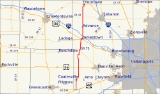
State Road 75, the highest two-digit route in the U.S. state
of Indiana
consists of two discontinuous north–south segments.
at the Putnam
-Hendricks
county line and runs northward through the towns of Coatesville
and North Salem
in Hendricks County
, and Jamestown
and Advance
in Boone County
. There is a junction with U.S. Route 136
at Jamestown, and a junction with Interstate 74
just to the north. The northern terminus is at State Road 47
in the town of Thorntown
.
.svg.png)
/ State Road 38
/ State Road 39
in Frankfort
in Clinton County
and runs northward, crossing State Road 26
east of Rossville
, and passing through the town of Flora
where it crosses State Road 18
. The northern terminus is at State Road 218
in the town of Camden
in Carroll County
.
In August 2008, the Indiana Department of Transportation awarded Carroll County a grant of $1.2 million to be used to extend the road 3 miles (4.8 km) north, to connect with the planned relocation of State Road 25.
.svg.png)
between Owensboro, Kentucky
and Rockport, Indiana
opened in September 1940, its northern end connected to a new nine-mile (14 km) stretch of state highway through Spencer County
that directed traffic to State Road 66
. As the Kentucky highway which connected to the bridge was designated Kentucky State Route 75, Indiana gave its connector road the same number.
In 1954, U.S. Route 231
was extended through Kentucky and Indiana, and the southernmost stretch of 231 in Indiana was routed along State Road 75. The Indiana Department of Highways removed State Road 75 from U.S. 231 in Spencer County by the early 1980s, along with all of U.S. 231's other concurrent designations throughout the state (others included State Road 45
and State Road 43
).
In October 2002, with the opening of the William H. Natcher Bridge
and the relocation of U.S. 231, this segment of highway was again redesignated, this time as the southern leg of State Road 161
.
|colspan=5 align="center" |Gap in route
U.S. state
A U.S. state is any one of the 50 federated states of the United States of America that share sovereignty with the federal government. Because of this shared sovereignty, an American is a citizen both of the federal entity and of his or her state of domicile. Four states use the official title of...
of Indiana
Indiana
Indiana is a US state, admitted to the United States as the 19th on December 11, 1816. It is located in the Midwestern United States and Great Lakes Region. With 6,483,802 residents, the state is ranked 15th in population and 16th in population density. Indiana is ranked 38th in land area and is...
consists of two discontinuous north–south segments.
Southern section
The southern section is about 37 miles (59.5 km) long. It begins at U.S. Route 40U.S. Route 40
U.S. Route 40 is an east–west United States highway. As with most routes whose numbers end in a zero, U.S. 40 once traversed the entire United States. It is one of the original 1920s U.S. Highways, and its first termini were San Francisco, California, and Atlantic City, New Jersey...
at the Putnam
Putnam County, Indiana
As of the census of 2000, there were 36,019 people, 12,374 households, and 9,119 families residing in the county. The population density was 75 people per square mile . There were 13,505 housing units at an average density of 28 per square mile...
-Hendricks
Hendricks County, Indiana
- Towns :*Amo*Avon*Brownsburg*Clayton*Coatesville*Danville*Lizton*North Salem*Pittsboro*Plainfield*Stilesville-Townships:*Brown*Center*Clay*Eel River*Franklin*Guilford*Liberty*Lincoln*Marion*Middle*Union*Washington-Further reading:...
county line and runs northward through the towns of Coatesville
Coatesville, Indiana
Coatesville is a town in Clay Township, Hendricks County, Indiana, United States. The population was 523 at the 2010 Census.-Geography:Coatesville is located at ....
and North Salem
North Salem, Indiana
North Salem is a town in Eel River Township, Hendricks County, Indiana, United States. The population was 518 at the 2010 Census.-Geography:North Salem is located at ....
in Hendricks County
Hendricks County, Indiana
- Towns :*Amo*Avon*Brownsburg*Clayton*Coatesville*Danville*Lizton*North Salem*Pittsboro*Plainfield*Stilesville-Townships:*Brown*Center*Clay*Eel River*Franklin*Guilford*Liberty*Lincoln*Marion*Middle*Union*Washington-Further reading:...
, and Jamestown
Jamestown, Indiana
Jamestown is a town in Jackson Township, Boone County and Eel River Township, Hendricks County, Indiana, United States. The population was 958 at the 2010 census.-Geography:Jamestown is located at ....
and Advance
Advance, Indiana
Advance is a town in Jackson Township, Boone County, Indiana, United States. The population was 477 at the 2010 census.-History:The town was platted in 1820 and was originally called Osceola; however, there was already a town of that name in the state, and so the name of Advance was chosen "in...
in Boone County
Boone County, Indiana
As of the census of 2000, there were 46,107 people, 17,081 households, and 12,810 families residing in the county. The population density was 109 people per square mile . There were 17,929 housing units at an average density of 42 per square mile...
. There is a junction with U.S. Route 136
U.S. Route 136
U.S. Highway 136 is a spur of U.S. Highway 36. It runs from Edison, Nebraska, at U.S. Highway 6 and U.S. Highway 34 to the Interstate 74/Interstate 465 interchange in Speedway, Indiana. This is a distance of 804 miles .-Nebraska:...
at Jamestown, and a junction with Interstate 74
Interstate 74
Interstate 74 is an Interstate Highway in the Midwestern and Southeastern United States. Its western end is at an intersection with Interstate 80 in Davenport, Iowa; the eastern end of its Midwest segment is at an intersection with Interstate 75 in Cincinnati, Ohio...
just to the north. The northern terminus is at State Road 47
Indiana State Road 47
State Road 47 in the U.S. state of Indiana is a state highway in west-central and central Indiana. Although State Road 47 is signed as a north–south highway, it runs more east–west.-Route description:...
in the town of Thorntown
Thorntown, Indiana
Thorntown is a town in Sugar Creek Township, Boone County, Indiana, United States. The population was 1,562 at the 2000 census. Thorntown is located in northwestern Boone City, about halfway between Lafayette and Indianapolis.-Geography:...
.
Northern section
The northern section is 22.7 miles (36.5 km) long. It begins at U.S. Route 421U.S. Route 421
U.S. Route 421 is a spur route of U.S. 21. It runs for from Michigan City, Indiana, at U.S. 20, to Fort Fisher in North Carolina. The highway goes through the cities of Indianapolis, Indiana, Lexington, Kentucky, Boone, North Carolina, Winston-Salem, North Carolina, Greensboro, North Carolina and...
/ State Road 38
Indiana State Road 38
State Road 38 in the U.S. State of Indiana serves as a connection between Lafayette in the west and Richmond in the east.-Route description:State Road 38 begins in Lafayette with State Road 25 and U.S. Route 52. There is an interchange with Interstate 65 at exit 168. It proceeds east-southeast...
/ State Road 39
Indiana State Road 39
State Road 39 in the U.S. State of Indiana is the name of two distinct north–south highways in the state of Indiana.-Southern section:Located in south-central Indiana, the shorter southern section of State Road 39 begins at State Road 56 west of Scottsburg. It runs north and passes through...
in Frankfort
Frankfort, Indiana
As of the census of 2000, there were 16,662 people, 6,279 households, and 4,175 families residing in the city. The population density was 3,240.5 people per square mile . There were 6,682 housing units at an average density of 1,299.6 per square mile...
in Clinton County
Clinton County, Indiana
As of the census of 2000, there were 33,866 people, 12,545 households, and 9,057 families residing in the county. The population density was 84 people per square mile . There were 13,267 housing units at an average density of 33 per square mile...
and runs northward, crossing State Road 26
Indiana State Road 26
State Road 26 is an east–west road in central Indiana in the United States that crosses the entire state from east to west, covering a distance of about .-Route description:...
east of Rossville
Rossville, Indiana
Rossville is a town in Ross Township, Clinton County, Indiana, United States. The population was 1,653 at the 2010 census. The town is named for John Ross, a pioneer settler and associate county judge.-History:...
, and passing through the town of Flora
Flora, Indiana
Flora is a town in Monroe Township, Carroll County, Indiana, United States. The population was 2,036 at the 2010 census. It is part of the Lafayette, Indiana Metropolitan Statistical Area.-Geography:Flora is located at ....
where it crosses State Road 18
Indiana State Road 18
State Road 18 in the U.S. State of Indiana is an east–west route in North Central Indiana running from the Illinois border in Benton County almost to the Ohio border, terminating at U.S. Route 27 /State Road 67 in Jay County...
. The northern terminus is at State Road 218
Indiana State Road 218
Indiana State Road 218 exists in two different sections in the central part of the U.S. state of Indiana, on either side of Mississinewa Lake. The road covers a total distance of about 91 miles; the ends of the two sections are separated by about 14 miles...
in the town of Camden
Camden, Indiana
Camden is a town in Jackson Township, Carroll County, Indiana, United States. The population was 611 at the 2010 census. It is part of the Lafayette, Indiana Metropolitan Statistical Area.-Geography:...
in Carroll County
Carroll County, Indiana
Carroll County is a county located in the U.S. state of Indiana. As of 2010, the population was 20,155. The county seat is Delphi.Carroll County is part of the Lafayette, Indiana, Metropolitan Statistical Area.- History :...
.
In August 2008, the Indiana Department of Transportation awarded Carroll County a grant of $1.2 million to be used to extend the road 3 miles (4.8 km) north, to connect with the planned relocation of State Road 25.
History
When the Glover Cary BridgeGlover Cary Bridge
The Glover H. Cary Bridge is a continuous truss bridge that spans the Ohio River between Owensboro, Kentucky and Spencer County, Indiana. It was named for the late U.S. Congressman Glover H. Cary , and opened to traffic in September 1940...
between Owensboro, Kentucky
Owensboro, Kentucky
Owensboro is the fourth largest city by population in the U.S. state of Kentucky. It is the county seat of Daviess County. It is located on U.S. Route 60 about southeast of Evansville, Indiana, and is the principal city of the Owensboro, Kentucky, Metropolitan Statistical Area. The city's...
and Rockport, Indiana
Rockport, Indiana
Rockport is a city in Ohio Township, Spencer County, Indiana, along the Ohio River. The population was 2,160 at the 2000 census. The city is the county seat of Spencer County.-History:...
opened in September 1940, its northern end connected to a new nine-mile (14 km) stretch of state highway through Spencer County
Spencer County, Indiana
As of the census of 2000, there were 20,391 people, 7,569 households, and 5,752 families residing in the county. The population density was 51 people per square mile . There were 8,333 housing units at an average density of 21 per square mile...
that directed traffic to State Road 66
Indiana State Road 66
State Road 66 is an east–west highway in six counties in the southernmost portion of the U.S. state of Indiana.-Route description:State Road 66 begins at the eastern end of a toll bridge over the Wabash River in New Harmony and ends at U.S. Route 150 east of Hardinsburg...
. As the Kentucky highway which connected to the bridge was designated Kentucky State Route 75, Indiana gave its connector road the same number.
In 1954, U.S. Route 231
U.S. Route 231
U.S. Route 231 is a parallel route of U.S. Route 31. It currently runs for 912 miles from St. John, Indiana, at U.S. Route 41 to south of U.S. Route 98 in Downtown Panama City, Florida.One of its most notable landmarks is the William H...
was extended through Kentucky and Indiana, and the southernmost stretch of 231 in Indiana was routed along State Road 75. The Indiana Department of Highways removed State Road 75 from U.S. 231 in Spencer County by the early 1980s, along with all of U.S. 231's other concurrent designations throughout the state (others included State Road 45
Indiana State Road 45
State Road 45 is a state route from Bean Blossom, Indiana to Scotland, Indiana in the southern half of the state.-Route description:From Bean Blossom and through Brown County, State Road 45 is a narrow, shoulderless two-lane road that passes between the Morgan-Monroe State Forest and the Yellowwood...
and State Road 43
Indiana State Road 43
-Southern section:This winding, two-lane section of State Road 43 connects Indiana State Road 46 in Owen County near McCormick's Creek State Park with Indiana State Road 54 in eastern Greene County. It covers a distance of .-Northern section:...
).
In October 2002, with the opening of the William H. Natcher Bridge
William H. Natcher Bridge
The William H. Natcher Bridge is a cable-stayed bridge that carries U.S. Highway 231 over the Ohio River. The bridge connects Owensboro, Kentucky to Rockport, Indiana and opened on October 21, 2002. It is named in honor of William Huston Natcher, a former United States Representative who served...
and the relocation of U.S. 231, this segment of highway was again redesignated, this time as the southern leg of State Road 161
Indiana State Road 161
State Road 161 in the U.S. State of Indiana is a rural undivided north–south highway in the southwestern portion of the state.-Route description:...
.
Major intersection
|-|colspan=5 align="center" |Gap in route