

Hydrography of Hungary
Encyclopedia
Hungary
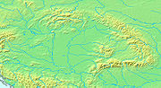
Hungary , officially the Republic of Hungary , is a landlocked country in Central Europe. It is situated in the Carpathian Basin and is bordered by Slovakia to the north, Ukraine and Romania to the east, Serbia and Croatia to the south, Slovenia to the southwest and Austria to the west. The...
's lying in the middle of the Carpathian Basin, half surrounded by the Carpathian Mountains
Carpathian Mountains
The Carpathian Mountains or Carpathians are a range of mountains forming an arc roughly long across Central and Eastern Europe, making them the second-longest mountain range in Europe...
. All parts of the country have some outflow. All surface water gravitates towards its southern centre, and from there, is united in the Danube
Danube
The Danube is a river in the Central Europe and the Europe's second longest river after the Volga. It is classified as an international waterway....
, which flows into the Black Sea
Black Sea
The Black Sea is bounded by Europe, Anatolia and the Caucasus and is ultimately connected to the Atlantic Ocean via the Mediterranean and the Aegean seas and various straits. The Bosphorus strait connects it to the Sea of Marmara, and the strait of the Dardanelles connects that sea to the Aegean...
. The whole of Hungary lies within the Danube drainage basin
Drainage basin
A drainage basin is an extent or an area of land where surface water from rain and melting snow or ice converges to a single point, usually the exit of the basin, where the waters join another waterbody, such as a river, lake, reservoir, estuary, wetland, sea, or ocean...
.
The total length of all the irrigation systems and inland waterways in the country is about 26000 km (16,155.7 mi).
The annual water balance of the country shows a surplus. Yearly about 100 km³ (3,531,466,621,266.1 cu ft) of water leaves the country towards the Black Sea. From that, precipitation
Precipitation (meteorology)
In meteorology, precipitation In meteorology, precipitation In meteorology, precipitation (also known as one of the classes of hydrometeors, which are atmospheric water phenomena is any product of the condensation of atmospheric water vapor that falls under gravity. The main forms of precipitation...
amounts for only 10%, the rest being provided by the incoming rivers of surrounding countries.
Rivers
Hydrographically Hungary can be divided into two roughly equal parts: the drainage basinDrainage basin
A drainage basin is an extent or an area of land where surface water from rain and melting snow or ice converges to a single point, usually the exit of the basin, where the waters join another waterbody, such as a river, lake, reservoir, estuary, wetland, sea, or ocean...
s of the Danube and the Tisza
Tisza
The Tisza or Tisa is one of the main rivers of Central Europe. It rises in Ukraine, and is formed near Rakhiv by the junction of headwaters White Tisa, whose source is in the Chornohora mountains and Black Tisa, which springs in the Gorgany range...
.
The present network of Hungary's rivers began to take shape at the end of the Tertiary
Tertiary
The Tertiary is a deprecated term for a geologic period 65 million to 2.6 million years ago. The Tertiary covered the time span between the superseded Secondary period and the Quaternary...
and the beginning of the Quaternary
Quaternary
The Quaternary Period is the most recent of the three periods of the Cenozoic Era in the geologic time scale of the ICS. It follows the Neogene Period, spanning 2.588 ± 0.005 million years ago to the present...
periods when the Pannonian Sea
Pannonian Sea
The Pannonian Sea was a shallow ancient sea located in the area today known as the Pannonian Plain in Central Europe. The Pannonian Sea existed during the Miocene and Pliocene epochs, when three to four kilometres of marine sediments were deposited in the Pannonian Basin.-History:The Pannonian Sea...
retreated from the basin.
The rivers in Hungary reach their lowest level at the end of the summer, the beginning of the autumn, or sometimes in the winter.
Both the Danube and the Tisza have two regular floods each year, the early spring "icy flood" and the early summer "green flood". The "icy flood" is the result of the thaw in the mountains surrounding the Carpathian Basin, when the rivers in the plain are usually still frozen. Before the river flows were controlled, the piled-up ice sheets of the river could form tremendous barriers, which in turn could cause devastating floods. This phenomenon can still be a real danger after cold winters, and a small fleet of icebreaker
Icebreaker
An icebreaker is a special-purpose ship or boat designed to move and navigate through ice-covered waters. Although the term usually refers to ice-breaking ships, it may also refer to smaller vessels .For a ship to be considered an icebreaker, it requires three traits most...
s is used on the two rivers to fight against ice barrages. The "green" flood in the early summer carries a much larger amount of water, not only the torrents from the Alps
Alps
The Alps is one of the great mountain range systems of Europe, stretching from Austria and Slovenia in the east through Italy, Switzerland, Liechtenstein and Germany to France in the west....
, but also the surface runoff
Surface runoff
Surface runoff is the water flow that occurs when soil is infiltrated to full capacity and excess water from rain, meltwater, or other sources flows over the land. This is a major component of the water cycle. Runoff that occurs on surfaces before reaching a channel is also called a nonpoint source...
water from the May and June rains.
Danube
The Danube runs through several countries, and in Hungary is known as the .History
The primaeval Danube first silted up the basin of the Pannonian Sea which now forms the Eastern Slovak LowlandEastern Slovak Lowland
The East Slovak Lowland is the name of the part of Great Hungarian Plain situated in Slovakia....
on the left bank of the river and the Little Hungarian Plain
Little Hungarian Plain
The Little Hungarian Plain or Little Alföld is a plain of appr. 8,000 km² in northwestern Hungary, south-western Slovakia , and eastern Austria...
on the right bank. It flowed towards the south into Transdanubia
Transdanubia
Transdanubia is a traditional region of Hungary.-Traditional interpretation:The borders of Transdanubia are the Danube river , the Drava and Mura rivers and the foothills of the Alps roughly along the border between Hungary and Austria .Transdanubia comprises the counties of Győr-Moson-Sopron,...
and then followed the present-day course of the Drava
Drava
Drava or Drave is a river in southern Central Europe, a tributary of the Danube. It sources in Toblach/Dobbiaco, Italy, and flows east through East Tirol and Carinthia in Austria, into Slovenia , and then southeast, passing through Croatia and forming most of the border between Croatia and...
into an interior lake system in the south of the present Great Plain. Later the Danube was diverted to the east by tectonic uplift
Tectonic uplift
Tectonic uplift is a geological process most often caused by plate tectonics which increases elevation. The opposite of uplift is subsidence, which results in a decrease in elevation. Uplift may be orogenic or isostatic.-Orogenic uplift:...
, finding an outlet through the Visegrád
Visegrád
Visegrád is a small castle town in Pest County, Hungary.Situated north of Budapest on the right bank of the Danube in the Danube Bend, Visegrád has a population 1,654 as of 2001...
gap. During the Quaternary
Quaternary
The Quaternary Period is the most recent of the three periods of the Cenozoic Era in the geologic time scale of the ICS. It follows the Neogene Period, spanning 2.588 ± 0.005 million years ago to the present...
the Great Plain continued to sink, meanwhile the Börzsöny
Börzsöny
Börzsöny is a mountain range in Northern Hungary. Its tallest peak is the Csóványos with 938 metres.It is the westernmost member of the North Hungarian Mountains, which in turn are part of the Inner Western Carpathians. The varied landscape offers good hiking opportunities. A large part of the...
and the Visegrád
Visegrád
Visegrád is a small castle town in Pest County, Hungary.Situated north of Budapest on the right bank of the Danube in the Danube Bend, Visegrád has a population 1,654 as of 2001...
mountains were rising. The result was the gorge, or a 200 metre deep terraced valley cut through the mountains by the Danube at what is now the Danube Bend at Visegrád, between Esztergom
Esztergom
Esztergom , is a city in northern Hungary, 46 km north-west of the capital Budapest. It lies in Komárom-Esztergom county, on the right bank of the river Danube, which forms the border with Slovakia there....
and Vác
Vác
Vác is a town in Pest county in Hungary with approximately 35,000 inhabitants. The archaic spellings of the name are Vacz and Vacs.-Location:...
. Once through the gorge, the Danube fanned out into the Great Hungarian Plain
Great Hungarian Plain
The Great Hungarian Plain is a plain occupying the southern and eastern part of Hungary, some parts of the Eastern Slovak Lowland, southwestern Ukraine, the Transcarpathian Lowland , western Romania , northern Serbia , and eastern Croatia...
, depositing alluvial cones
Alluvium
Alluvium is loose, unconsolidated soil or sediments, eroded, deposited, and reshaped by water in some form in a non-marine setting. Alluvium is typically made up of a variety of materials, including fine particles of silt and clay and larger particles of sand and gravel...
. The present north-south course was formed by the river in the late Pleistocene
Pleistocene
The Pleistocene is the epoch from 2,588,000 to 11,700 years BP that spans the world's recent period of repeated glaciations. The name pleistocene is derived from the Greek and ....
.
Geography
The Danube is the second longest river in Europe, after the Volga. Its upper flow is outside of Hungary, but its middle section starts at DevínDevín
Devín originally a separate town at the confluence of the Danube and Morava rivers, is now a suburb of Bratislava, the capital of Slovakia. It is an important archaeological site, famous for the ruins of Devín Castle...
, close to the Hungarian border. This section of the river stretches until the Iron Gate
Iron Gate (Danube)
The Iron Gates The gorge lies between Romania in the north and Serbia in the south. At this point, the river separates the southern Carpathian Mountains from the northwestern foothills of the Balkan Mountains. The Romanian, Hungarian, Slovakian, Turkish, German and Bulgarian names literally mean...
, between Serbia
Serbia
Serbia , officially the Republic of Serbia , is a landlocked country located at the crossroads of Central and Southeast Europe, covering the southern part of the Carpathian basin and the central part of the Balkans...
and Romania
Romania
Romania is a country located at the crossroads of Central and Southeastern Europe, on the Lower Danube, within and outside the Carpathian arch, bordering on the Black Sea...
. The lower section of the river crosses the Romanian Plain
Romanian Plain
The Romanian Plain is located in southern Romania and the easternmost tip of Serbia. Part of the historical region of Wallachia, it is bordered by the Danube River in the east, south and west, and by the Getic Plateau in the north. Bucharest, the capital of Romania, is located in the central part...
and flows into the Black Sea
Black Sea
The Black Sea is bounded by Europe, Anatolia and the Caucasus and is ultimately connected to the Atlantic Ocean via the Mediterranean and the Aegean seas and various straits. The Bosphorus strait connects it to the Sea of Marmara, and the strait of the Dardanelles connects that sea to the Aegean...
through a delta
River delta
A delta is a landform that is formed at the mouth of a river where that river flows into an ocean, sea, estuary, lake, reservoir, flat arid area, or another river. Deltas are formed from the deposition of the sediment carried by the river as the flow leaves the mouth of the river...
. The Hungarian section of the river is 417 km (259.1 mi) long, from which 140 km (87 mi) forms the border between Hungary and Slovakia
Slovakia
The Slovak Republic is a landlocked state in Central Europe. It has a population of over five million and an area of about . Slovakia is bordered by the Czech Republic and Austria to the west, Poland to the north, Ukraine to the east and Hungary to the south...
, from Rusovce
Rusovce
Rusovce castle")) is a borough in southern Bratislava on the right bank of the Danube river, close to the Hungarian border.- History :In the 1st century, there was a Roman settlement named Gerulata in today's Rusovce area. The first preserved written reference to the settlement is from 1208. It...
to the mouth of the Ipeľ
Ipel
Ipeľ or Ipoly is a 232 km long river in Slovakia and Hungary, tributary to the river Danube. Its source is in central Slovakia in the Slovenské rudohorie Mountains...
.
Navigation
The Danube is navigable for the whole of its course through Hungary with a minimum 2 metres (6.6 ft) depth.Flow and flooding
The Danube has been mostly controlled since the 19th century. There is about 1250 km² (482.6 sq mi) of flood-protected area along the banks of the Danube in Hungary, with about 1123000 km³ (269,422 cu mi) of dykes. No stretch of land along the river is left open to the floods.The Danube has a rate of flow of 10000 m3/s at its fastest, and 600 m3/s at its slowest, in the region of Budapest. The difference between water levels can be as high as 6 metre. The present flood prevention possibilities are enough to cope with rises up to about 10 metres (33 ft) above the low-water mark, but there are from time to time very dangerous floods.
Tributaries
The right-hand tributaries of the Danube inside Hungary do not add greatly to its volume. The largest are the Lajta, the RábaRába
The Rába is a river in southeastern Austria and western Hungary and a right tributary of the Danube. Its source is in Austria, some kilometres east of Bruck an der Mur below Heubodenhöhe Hill. It flows through the Austrian states of Styria and Burgenland, and the Hungarian counties of Vas and...
, the Rábca
Rabca
Rabča is a large village and municipality in Námestovo District in the Žilina Region of northern Slovakia.-Geography:The municipality lies at an altitude of 661 metres and covers an area of 25.157km². It has a population of about 4360 people....
and the Marcal
Marcal
The Marcal is a right tributary of the Rába which has its source near Sümeg in the Bakony region of western Hungary. The river flows north and reaches Ukk on the Little Hungarian Plain. It follows a path similar to the Rába, and in many places the two rivers are only a kilometer apart...
. The Sárvíz is joined by the Sió
Sió
Sió is an artificial channel in central Hungary. It is the outlet of Lake Balaton. It flows out of the lake in the city Siófok. It flows along the city Szekszárd, and a few km east of this city it flows into the river Danube. The river Sió flows through the Hungarian counties Somogy, Fejér and Tolna....
which drains Lake Balaton. The Sió is also fed by the river Kapos.
The only right-hand tributary of any considerable volume is the Drava
Drava
Drava or Drave is a river in southern Central Europe, a tributary of the Danube. It sources in Toblach/Dobbiaco, Italy, and flows east through East Tirol and Carinthia in Austria, into Slovenia , and then southeast, passing through Croatia and forming most of the border between Croatia and...
, which forms also on a large stretch the Hungarian-Croatia
Croatia
Croatia , officially the Republic of Croatia , is a unitary democratic parliamentary republic in Europe at the crossroads of the Mitteleuropa, the Balkans, and the Mediterranean. Its capital and largest city is Zagreb. The country is divided into 20 counties and the city of Zagreb. Croatia covers ...
n border, but joins the Danube already inside Croatia.
History
The present course of the TiszaTisza
The Tisza or Tisa is one of the main rivers of Central Europe. It rises in Ukraine, and is formed near Rakhiv by the junction of headwaters White Tisa, whose source is in the Chornohora mountains and Black Tisa, which springs in the Gorgany range...
was established relatively recently in geological time. Until the end of the Pleistocene
Pleistocene
The Pleistocene is the epoch from 2,588,000 to 11,700 years BP that spans the world's recent period of repeated glaciations. The name pleistocene is derived from the Greek and ....
it flowed along the southern border of the Nyírség area in north-eastern Hungary, but later it changed its flow forming a right-angled bend to the north of the Nyírség. The Tisza and its tributaries built up very large, but flat alluvial cones along the edges of the Great Plain.
Geography
The drainage basinDrainage basin
A drainage basin is an extent or an area of land where surface water from rain and melting snow or ice converges to a single point, usually the exit of the basin, where the waters join another waterbody, such as a river, lake, reservoir, estuary, wetland, sea, or ocean...
of the Tisza is in the eastern part of the Carpathian Basin. 45000 km² (17,374.6 sq mi) of this is in Hungary, mostly lowland. Before its control in the 19th century its full length was 1419 km (881.7 mi), of which 955 km (593.4 mi) were within the present boundaries of Hungary. Its control shortened these lengths to 977 km (607.1 mi) and 579 km (359.8 mi) respectively. In spite of regulation, the Tisza still has a characteristically wide meander
Meander
A meander in general is a bend in a sinuous watercourse. A meander is formed when the moving water in a stream erodes the outer banks and widens its valley. A stream of any volume may assume a meandering course, alternately eroding sediments from the outside of a bend and depositing them on the...
s through the flood plain with sand dunes, wide forests and oxbow lake
Oxbow lake
An oxbow lake is a U-shaped body of water formed when a wide meander from the main stem of a river is cut off to create a lake. This landform is called an oxbow lake for the distinctive curved shape, named after part of a yoke for oxen. In Australia, an oxbow lake is called a billabong, derived...
s, some cut off artificially, some naturally. In Hungary the Tisza is a sluggish river with a very gentle gradient
Slope
In mathematics, the slope or gradient of a line describes its steepness, incline, or grade. A higher slope value indicates a steeper incline....
. Before it was brought under control it regularly flooded an area of 2000 km² (772.2 sq mi). The volume of water in the Tisza fluctuates even more than that in the Danube because the catchment area is mostly medium-height mountains, and not by high mountains with permanent snow.
Flow and flooding
The Tisza has three floods yearly, the early spring flood from the snow thaw, then the early summer "green flood", brought on by the summer rain, and then a minor flood in the autumn. Its lowest level is in winter.The rate of flow varies at Szolnok
Szolnok
Szolnok is the county seat of Jász-Nagykun-Szolnok county in central Hungary. Its location on the banks of the Tisza river, at the heart of the Great Hungarian Plain, has made it an important cultural and economic crossroads for centuries....
between 72 m3/s and 3800 m3/s Before the extensive controls, when the spring floods of the Danube and the Tisza happened to coincide, the Danube could not absorb the water of the Tisza and the resulting flood could cause immense damage throughout the Great Plain. The length of the Tisza dykes now exceeds 4000 km (2,485.5 mi).
Navigation
The Tisza is navigable for smaller vessels right up to DombrádDombrád
Dombrád is a town in Szabolcs-Szatmár-Bereg county, in the Northern Great Plain region of eastern Hungary.-Geography:It covers an area of and has a population of 4243 people ....
near the north-eastern frontier of the country. In the Trans-Tisza Region (east of the river) extensive areas are irrigated by its water.
Tributaries
The last and largest tributary of the Tisza within Hungary is the MarosMaros
Maros is a town in the South Sulawesi province of Indonesia; it is the capital of the Maros Regency. Nearby is a prehistoric cave that has been submitted to the UNESCO World Heritage Tentative list.- References :...
.
Among the tributaries of the Tisza the most important on the right side is the Bodrog
Bodrog
The Bodrog is a river in eastern Slovakia and north-eastern Hungary. It is a tributary to the river Tisza. The Bodrog is formed by the confluence of the rivers Ondava and Latorica near Zemplin in eastern Slovakia...
, which flows into the Tisza at Tokaj
Tokaj
Tokaj , is a historical town in Borsod-Abaúj-Zemplén county, Northern Hungary, 54 kilometers from county capital Miskolc. It is the centre of the famous Tokaj-Hegyalja wine district where the world famous Tokaji wine is produced.- History :...
. Their confluence has often changed, as is graphically illustrated by the extensive oxbow lakes and belts of shallows in the vicinity of Tokaj.
The next right-hand tributary of the Tisza is the Hernád, which receives earlier also the waters of the Bódva
Bodva
The Bodva is a 110-km long river in Slovakia and Hungary. Its source is in the Slovenské rudohorie Mountains. The river crosses the border with Hungary near Turňa nad Bodvou, and it flows into the river Sajó in Boldva, north of Miskolc...
and the Sajó
Sajó
The Sajó is a river in Slovakia and Hungary.Its length is 229 km, of which 110 km is in Slovakia. Its source is in the Stolica Mountains range of the Slovak Ore Mountains. It flows through the Slovak town Rožňava and the Hungarian city Miskolc. In Hungary it flows through the county of...
. Below Tiszafüred
Tiszafüred
Tiszafüred is a town in Jász-Nagykun-Szolnok county, in the Northern Great Plain region of central Hungary.-Geography:It covers an area of and has a population of 13,953 people .-External links:*...
the river takes up the Eger river and at Szolnok the Zagyva
Zagyva
The Zagyva is a river in Hungary. Its length is 160 km, and drains an area of about 5,677 km². The source is near Salgótarján in Nógrád county. It flows through the towns of Bátonyterenye, Pásztó, Hatvan and Jászberény and flows into the Tisza River at Szolnok. Average discharge at Szolnok is 9 m³/s....
which already collected the waters of Galga and Tápió
Tapio
Tapio may refer to*Tapio, a Finnish male given name*Tapio, an East Finnish forest spirit or god. He lends his name in the form of*Forestry Development Centre Tapio, Finnish organisation, that produces solutions for sustainable forest management....
. To the south from this point no more streams run into the Tisza from the ridge which separates it from the Danube. The eastern slope of this ridge is only broken by dried-out valleys.
The more significant left-hand tributes of the Tisza include the Szamos with the Kraszna
Crasna River (Tisza)
The Crasna or Kraszna is the name of a river in northwestern Romania and northeastern Hungary.The Crasna is a tributary of the Tisza River. Its source is in Transylvania, Romania, near the village of Crasna. It flows through the Romanian counties Sălaj and Satu Mare and the Hungarian county...
, the Körös
Körös River
Körös is the name of a 195 km long river in eastern Hungary. It is formed at the confluence of the rivers Fehér-Körös and Fekete-Körös near Gyula. The Sebes-Körös flows into the Körös near Gyomaendrőd...
, which is usually called Treble Körös, because it gathers up the water of several minor rivers, (White Körös, Black Körös, Rapid Körös, Berettyó and the Hortobágy river
Hortobágy
Hortobágy is both the name of a village in Hajdú-Bihar county and an 800 km² national park in Eastern Hungary, rich with folklore and cultural history. The park, a part of the Alföld , was designated as a national park in 1973 , and elected among the World Heritage sites in 1999...
). Before the great river controls of the 19th century this region was an almost endless stretch of marshlands and fen
Fen
A fen is a type of wetland fed by mineral-rich surface water or groundwater. Fens are characterised by their water chemistry, which is neutral or alkaline, with relatively high dissolved mineral levels but few other plant nutrients...
s. Today there is a system of irrigation canals in the area.
Canals
The river is spelt Tisa in other languages. In Hungarian the spelling is Tisza, but it is not assonated.In the late century, during the large-scale controls, canal systems were also created partly as artificial waterways, partly to help the agricultural use of land, and partly to conduct away superfluous inland water. The most important canal of Transdanubia
Transdanubia
Transdanubia is a traditional region of Hungary.-Traditional interpretation:The borders of Transdanubia are the Danube river , the Drava and Mura rivers and the foothills of the Alps roughly along the border between Hungary and Austria .Transdanubia comprises the counties of Győr-Moson-Sopron,...
is the 100 km (62.1 mi) Sió
Sió
Sió is an artificial channel in central Hungary. It is the outlet of Lake Balaton. It flows out of the lake in the city Siófok. It flows along the city Szekszárd, and a few km east of this city it flows into the river Danube. The river Sió flows through the Hungarian counties Somogy, Fejér and Tolna....
connecting Lake Balaton and the Danube. The Hanság Canal goes across a boggy land between the Lake Fertő and the Danube. The 97 km (60.3 mi) long Main Eastern Canal, which was only finished after 1945, crosses the drier parts of the Great Hungarian Plain
Great Hungarian Plain
The Great Hungarian Plain is a plain occupying the southern and eastern part of Hungary, some parts of the Eastern Slovak Lowland, southwestern Ukraine, the Transcarpathian Lowland , western Romania , northern Serbia , and eastern Croatia...
to the east of the Tisza.
Lakes
Pleistocene
The Pleistocene is the epoch from 2,588,000 to 11,700 years BP that spans the world's recent period of repeated glaciations. The name pleistocene is derived from the Greek and ....
. There is no really deep lake in the country. The shallower waters warm up quickly in summer, and water temperatures of 25 °C (77 °F) are quite common, which makes them very pleasant for bathing.
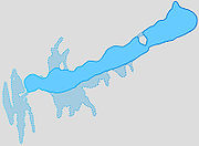
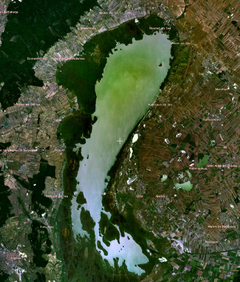
Lake Balaton
Lake Balaton
Lake Balaton is a freshwater lake in the Transdanubian region of Hungary. It is the largest lake in Central Europe, and one of its foremost tourist destinations. As Hungary is landlocked , Lake Balaton is often affectionately called the "Hungarian Sea"...
is the biggest in Central Europe. It covers 600 km² (231.7 sq mi), being 77 km (47.8 mi) long and up to 15 km (9.3 mi) wide. It lies 104 m (341.2 ft) above mean sea level and has an average depth of 3 m (9.8 ft), with its deepest point being at Tihany
Tihany
Tihany is a village on the northern shore of Lake Balaton on the Tihany Peninsula . The whole peninsula is a historical district....
, at 10.8 m (35.4 ft).
Evaporation
Evaporation
Evaporation is a type of vaporization of a liquid that occurs only on the surface of a liquid. The other type of vaporization is boiling, which, instead, occurs on the entire mass of the liquid....
from the lake is greater than the inflow from small rivers and streams. The deficit is compensated by rainwater and underground sources. The occasional surplus water leaves the lake through the canalised Sió.
During the Pleistocene the lake was much larger, and 20 metre deep.
The southern shore of Lake Balaton is extremely shallow, the average depth only beiong reached at a distance of 500 metre from the shore. There is a 70 km (43.5 mi) long beach ridge
Beach ridge
A beach ridge is a wave-swept or wave-deposited ridge running parallel to a shoreline. It is commonly composed of sand as well as sediment worked from underlying beach material. The movement of sediment by wave action is called littoral transport. Movement of material parallel to the shoreline is...
, covered by sand, on the southern shore, built up by the waves underneath the dominant north-westerly wind.
The northern shore is more varied, with the Tihany
Tihany
Tihany is a village on the northern shore of Lake Balaton on the Tihany Peninsula . The whole peninsula is a historical district....
Peninsula, and it has steeper beach shelves.
At the lake the summertime is long, beginning in May and lingering to the end of September. The air temperature may be in the region of 30 °C (86 °F) to 35 °C (95 °F), the water temperature 24 °C (75.2 °F) to 30 °C (86 °F). The water temperature does not sink below 17 °C (62.6 °F) to 18 °C (64.4 °F)in the summer even if there is a cold front
Cold front
A cold front is defined as the leading edge of a cooler mass of air, replacing a warmer mass of air.-Development of cold front:The cooler and denser air wedges under the less-dense warmer air, lifting it...
. This enormous body of water creates a very pleasant mesoclimate on the shores of the lake.
Sudden storms can whip up dangerous, steep waves on the surface of the lake. Their average height is 1 metres (3.3 ft), and their average length is 7 metres (23 ft). A prevailing north-easterly or south-westerly wind can push the water from the eastern basin of the lake (to the east of the Tihany Peninsula) into the western basin or on the contrary, resulting in water levels differing by 0.4 to 0.6 m (1.3 to 2 ft) from normal, which creates strong currents.
The lake freezes almost every winter, the thickness of the ice can reach 0.4 metres (1.3 ft), which creates good opportunities for sport.
Austria
Austria , officially the Republic of Austria , is a landlocked country of roughly 8.4 million people in Central Europe. It is bordered by the Czech Republic and Germany to the north, Slovakia and Hungary to the east, Slovenia and Italy to the south, and Switzerland and Liechtenstein to the...
. Its water level and shore line have been changed over time very widely. The lake is very shallow, with an average water level of 1.5 m (4.9 ft). The greater part of its surface is covered with reeds, huge quantities of which are used industrially. A quarter of the lake's area of 335 km² (129.3 sq mi) lies in Hungary, with the other three-quarters in Austria. The adjacent marshy Hanság was drained by the Hanság Canal.
The third largest lake in Hungary, Lake Velence
Lake Velence
Lake Velence is the third largest lake in Hungary. It is a popular holiday destination among Hungarians.The lake has an area of 26 km2., one third of which is covered by the common reed...
is a steppe lake in an advanced stage of alluviation. Its surface area is 26 km² (10 sq mi), but only 16 km² (6.2 sq mi) is open water, the rest being covered by reeds. It is a popular holiday resort, being close to Budapest
Budapest
Budapest is the capital of Hungary. As the largest city of Hungary, it is the country's principal political, cultural, commercial, industrial, and transportation centre. In 2011, Budapest had 1,733,685 inhabitants, down from its 1989 peak of 2,113,645 due to suburbanization. The Budapest Commuter...
.
Swamps and marshes
The Little Balaton was originally a part of the larger lake, but now it is mostly a swamp and marsh area at the south-western corner of the Balaton with a highly characteristic wildlife. It is a protected natural reserve.Before the extensive controls of the 19th century there were a lot of marshes and swamps in the country like the Sárrét of Transdanubia or the Ecsed
Ecsed
Ecsed is a small village in Hungary. There is an old town of Ecsed in the eastern part of Hungary that has been renamed Nagyecsed, meaning "grand" or "great Ecsed"....
Moorland close to the north-eastern corner of the country. They have been drained, reclaimed and transformed into land fit for farming.
Spring-water lakes are a special class of natural lakes in Hungary. They are fed mostly by warm springs, but karstic
Karst topography
Karst topography is a geologic formation shaped by the dissolution of a layer or layers of soluble bedrock, usually carbonate rock such as limestone or dolomite, but has also been documented for weathering resistant rocks like quartzite given the right conditions.Due to subterranean drainage, there...
ones also occur (Lake Hévíz
Lake Hévíz
Lake Hévíz is located close to Hévíz, Hungary, near the western end of Lake Balaton, five miles from Keszthely.It is the second largest thermal lake in the world...
, the Malom Pool in Budapest, Tapolca
Tapolca
Tapolca is a town in Veszprém county, Hungary, close to Lake Balaton. It is located at around .The town has a separate district approximately 5 km to the East called Tapolca-Diszel.- The Lake Cave :...
). The alkaline Lake Fehér near Szeged
Szeged
' is the third largest city of Hungary, the largest city and regional centre of the Southern Great Plain and the county town of Csongrád county. The University of Szeged is one of the most distinguished universities in Hungary....
has no outlet. It is a famous nature reserve in Körös-Maros National Park
Körös-Maros National Park
Körös-Maros National Park is one of the 10 national parks in Hungary , located in Békés county, in the Southern Great Plain. The park was created in 1997 for the protection of birds....
.
Underground water
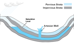
Stratum
In geology and related fields, a stratum is a layer of sedimentary rock or soil with internally consistent characteristics that distinguish it from other layers...
water is abundant because Hungary is in the middle of the Carpathian Basin. These water resources are between two impermeable strata underlying the first impervious stratum beneath the underground water. They are predominantly of rainfall origin, but mostly not from Hungary, but from the surrounding higher-lying parts of the Carpathian Basin. This water, when brought to the surface from great depths, is rich in various mineral solutions and may be very hot.
Deep boring
Boring (earth)
Boring is drilling a hole, tunnel, or well in the earth.-Earth boring:Boring is used for a wide variety of applications in geology, agriculture, hydrology, civil engineering, and oil and natural gas industries...
for stratum water has been carried out throughout the country. There are about twenty-eight thousand artesian wells in the Great Plain alone, out of a total of thirty-five thousand for the whole country. Their depth varies from 100 to 2500 m (328.1 to 8,202.1 ft). In the hilly and mountainous regions of Mesozoic
Mesozoic
The Mesozoic era is an interval of geological time from about 250 million years ago to about 65 million years ago. It is often referred to as the age of reptiles because reptiles, namely dinosaurs, were the dominant terrestrial and marine vertebrates of the time...
limestone
Limestone
Limestone is a sedimentary rock composed largely of the minerals calcite and aragonite, which are different crystal forms of calcium carbonate . Many limestones are composed from skeletal fragments of marine organisms such as coral or foraminifera....
, karstic
Karst topography
Karst topography is a geologic formation shaped by the dissolution of a layer or layers of soluble bedrock, usually carbonate rock such as limestone or dolomite, but has also been documented for weathering resistant rocks like quartzite given the right conditions.Due to subterranean drainage, there...
water is also important.
Source
20|editor=Ferenc Erdei
|publisher=Pergamon Press
|year=1968
}}