
.gif)
Hurricane Gabrielle (1989)
Encyclopedia
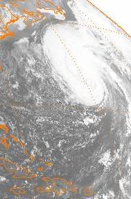
Hurricane Gabrielle was the seventh named storm, fourth hurricane and first major hurricane of the 1989 Atlantic hurricane season
. Gabrielle formed from a tropical depression on August 30, 1989, and moved west-northwestward before recurving and becoming a Category 4 hurricane on September 5. Gabrielle reached a peak intensity of 145 mph (225 km/h) before weakening into a tropical storm seven days later and dissipating southeast of Atlantic Canada
on September 13.
Although the storm never made landfall, its large size and powerful winds produced high surf across the northern Leeward Islands
, Bermuda
and Eastern United States
. The waves caused nine fatalities (eight in the United States
and one in Canada
) and moderate beach erosion.
, the depression tracked westward as a high pressure ridge formed between the two storms. Satellite imagery showed the storm developing a good outflow pattern and the data from the satellite imagery prompted the National Hurricane Center
to upgrade the system to tropical storm status and name it Gabrielle on August 31, 1989.
Tropical Storm Gabrielle then moved westward at 17 mph (27 km/h) where it rapidly reached hurricane strength late on September 2, 625 miles (1006 km) west of Cape Verde
. On the same day, Gabrielle's winds reached to 105 mph (169 km/h) as the storm was 1,200 miles (1,931 km) east of the Leeward Islands
. By September 3, a ridge of high pressure
formed a wedge between Gabrielle and Felix and on September 4, a trough extending from the Atlantic Canada
southeastward to Florida
caused Gabrielle to recurve northwestward, which had already reached Category 4 status at that point. On September 5, hurricane hunter aircraft reported winds of at least 74 mph extending 100 miles (161 km) from the center and tropical storm force winds 250 miles (402 km) from the center as Gabrielle recurved west-northwest at 15 mph (24 km/h).
Hours later, another recon flight into Gabrielle revealed that the barometric pressure was slowly rising and the eye
began to expand which is sign that the storm was slowly weakening. However, forecasters were unsure if the weakening was temporary or definite prompting one meteorologist to say that "Gabrielle may have reached its peak intensity, but its too early to tell"-to explain the uncertainty of Gabrielle’s strength and if the storm will strengthen even further. The concerns were addressed when Gabrielle reached a peak intensity of 145 mph (225 km/h) and a low barometric pressure of 939 millibars although the National Hurricane Center
suggested the barometric pressure may have ranged from 935 to 944 millibars. The storm passed northeastward of the Leeward Islands
and turned northward in response to a weakening in the ridge
of high pressure
caused by Hurricane Felix. Moving northward at 14 mph (23 km/h) , the winds of Gabrielle weakened as it bypassed Bermuda
as a Category 2 hurricane.
Gabrielle then weakened to a Category 1 hurricane before it stalled 475 miles (764 km) southeast of Cape Cod, Massachusetts by September 10 as it interacted with a frontal trough
extending north to south across the western Atlantic Ocean
. Embedded in the jet stream
, Gabrielle drifted slowly westward as it weakened to a tropical storm and recurved again to the east in response to an approaching cold front
. Gabrielle then dissipated on September 12 and merged with a developing extratropical storm on September 13.
stated in its forecast on September 3 that Gabrielle has a 10 percent chance of affecting the Leeward Islands
in three days. On September 5, meteorologists forecast the storm to bypass north of the Virgin Islands
and told the press that it is too early to suggest that the storm might hit the United States
four or five days ahead of its current position. In Jamaica
, although Gabrielle was not officially forecast to hit the island, a missionary traveling across the island told residents about a prophecy that Jamaica will face doom and suggested that the disaster might be ether Hurricane Gabrielle or another hurricane in the near future.
As Hurricane Gabrielle moved west-northwest, forecasters at the National Hurricane Center
advised residents along the East Coast of the United States
to monitor the storm because of its large size and strong swells it is producing. When Gabrielle, recurved northwestward, the National Hurricane Center
forecast the outer edge of the hurricane to graze Bermuda, bringing tropical storm force winds and strong waves to the island. In Bermuda, cruise ship
s and other water craft were advised of rough seas and many residents rushed to stores to buy emergency supplies.
 Numerous ships came in contact with Hurricane Gabrielle, two of the ships reported winds of 60 mph (97 km/h) and barometric pressures of 992 and 997 millibars. None of the ships reported any damage.
, Gabrielle brought 10 ft (3 m) waves and flooding to the island nation, causing minor damage. There were no fatalities or injuries. In Dominica
and Guadeloupe
, waves from Gabrielle caused severe beach erosion along the north and east coasts of the island but moderate damage was reported. However, the erosion brought by Gabrielle and later Hurricane Hugo
resulted loss of 14 ft (4.4 m) of beach. The Caribbean islands of Nevis
and British Virgin Islands
also sustained minor to moderate beach erosion. In Bermuda
, waves of 10–20 ft (4.6–6 m) were reported.
, North Carolina
reported swells up to 10 feet (3 meters). Waves between 5 to 13 feet (1.5–4 meters) were reported along the East Coast of the United States
from Florida
to Maryland
. In Rhode Island
two teenagers were rescued by the United States Coast Guard
after being swept into the water by the wave
s. In Tenants Harbor, Maine, a 19 year old woman drowned after slipping off a rock shoreline. Two men who were with her tried to rescue the woman but to no avail as the rough seas overpowered them. The men themselves were later rescued by the crew of a fishing boat.
In New Hampshire
, the United States Coast Guard
rescued two surfers while looking for a swimmer who was reported missing earlier. Near Boston, Massachusetts, a 25 year old man was reported missing in the Ipswich River
north of Cape Ann
after a motorboat capsized in the rough surf. Two other occupants including an infant
were rescued. In New York City
, a 37 year old man was reported missing and presumed dead after his houseboat capsized in the heavy surf. Another houseboat
also capsized, drowning a 58 year old woman. On shore, a large wave swept two fishermen into the sea, where they drowned. Overall, Hurricane Gabrielle left eight people dead. No damage estimate from Gabrielle’s impact on the United States
exists.
 In Atlantic Canada
, Gabrielle produced waves 20–30 feet (6.1-9.1 meters) high along the south coast of Nova Scotia
. One fatality was reported in Atlantic Canada when a man drowned near Ketch Harbour when a wave swept him into the ocean
.
1989 Atlantic hurricane season
The 1989 Atlantic hurricane season was an active season that produced fifteen tropical cyclones, eleven named storms, seven hurricanes, and two major hurricanes. The season was officially designated from June 1, 1989, to November 30, 1989, dates which conventionally...
. Gabrielle formed from a tropical depression on August 30, 1989, and moved west-northwestward before recurving and becoming a Category 4 hurricane on September 5. Gabrielle reached a peak intensity of 145 mph (225 km/h) before weakening into a tropical storm seven days later and dissipating southeast of Atlantic Canada
Atlantic Canada
Atlantic Canada is the region of Canada comprising the four provinces located on the Atlantic coast, excluding Quebec: the three Maritime provinces – New Brunswick, Prince Edward Island, and Nova Scotia – and Newfoundland and Labrador...
on September 13.
Although the storm never made landfall, its large size and powerful winds produced high surf across the northern Leeward Islands
Leeward Islands
The Leeward Islands are a group of islands in the West Indies. They are the northern islands of the Lesser Antilles chain. As a group they start east of Puerto Rico and reach southward to Dominica. They are situated where the northeastern Caribbean Sea meets the western Atlantic Ocean...
, Bermuda
Bermuda
Bermuda is a British overseas territory in the North Atlantic Ocean. Located off the east coast of the United States, its nearest landmass is Cape Hatteras, North Carolina, about to the west-northwest. It is about south of Halifax, Nova Scotia, Canada, and northeast of Miami, Florida...
and Eastern United States
United States
The United States of America is a federal constitutional republic comprising fifty states and a federal district...
. The waves caused nine fatalities (eight in the United States
United States
The United States of America is a federal constitutional republic comprising fifty states and a federal district...
and one in Canada
Canada
Canada is a North American country consisting of ten provinces and three territories. Located in the northern part of the continent, it extends from the Atlantic Ocean in the east to the Pacific Ocean in the west, and northward into the Arctic Ocean...
) and moderate beach erosion.
Meteorological history
A tropical wave moved off the coast of Africa on August 28 and developed a well organized circulation and became Tropical Depression Ten on August 30. Located 1,000 miles (1609 km) southeast of Tropical Storm Felix1989 Atlantic hurricane season
The 1989 Atlantic hurricane season was an active season that produced fifteen tropical cyclones, eleven named storms, seven hurricanes, and two major hurricanes. The season was officially designated from June 1, 1989, to November 30, 1989, dates which conventionally...
, the depression tracked westward as a high pressure ridge formed between the two storms. Satellite imagery showed the storm developing a good outflow pattern and the data from the satellite imagery prompted the National Hurricane Center
National Hurricane Center
The National Hurricane Center , located at Florida International University in Miami, Florida, is the division of the National Weather Service responsible for tracking and predicting weather systems within the tropics between the Prime Meridian and the 140th meridian west poleward to the 30th...
to upgrade the system to tropical storm status and name it Gabrielle on August 31, 1989.
Tropical Storm Gabrielle then moved westward at 17 mph (27 km/h) where it rapidly reached hurricane strength late on September 2, 625 miles (1006 km) west of Cape Verde
Cape Verde
The Republic of Cape Verde is an island country, spanning an archipelago of 10 islands located in the central Atlantic Ocean, 570 kilometres off the coast of Western Africa...
. On the same day, Gabrielle's winds reached to 105 mph (169 km/h) as the storm was 1,200 miles (1,931 km) east of the Leeward Islands
Leeward Islands
The Leeward Islands are a group of islands in the West Indies. They are the northern islands of the Lesser Antilles chain. As a group they start east of Puerto Rico and reach southward to Dominica. They are situated where the northeastern Caribbean Sea meets the western Atlantic Ocean...
. By September 3, a ridge of high pressure
High pressure
High pressure in science and engineering is studying the effects of high pressure on materials and the design and construction of devices, such as a diamond anvil cell, which can create high pressure...
formed a wedge between Gabrielle and Felix and on September 4, a trough extending from the Atlantic Canada
Atlantic Canada
Atlantic Canada is the region of Canada comprising the four provinces located on the Atlantic coast, excluding Quebec: the three Maritime provinces – New Brunswick, Prince Edward Island, and Nova Scotia – and Newfoundland and Labrador...
southeastward to Florida
Florida
Florida is a state in the southeastern United States, located on the nation's Atlantic and Gulf coasts. It is bordered to the west by the Gulf of Mexico, to the north by Alabama and Georgia and to the east by the Atlantic Ocean. With a population of 18,801,310 as measured by the 2010 census, it...
caused Gabrielle to recurve northwestward, which had already reached Category 4 status at that point. On September 5, hurricane hunter aircraft reported winds of at least 74 mph extending 100 miles (161 km) from the center and tropical storm force winds 250 miles (402 km) from the center as Gabrielle recurved west-northwest at 15 mph (24 km/h).
Hours later, another recon flight into Gabrielle revealed that the barometric pressure was slowly rising and the eye
Eye (cyclone)
The eye is a region of mostly calm weather found at the center of strong tropical cyclones. The eye of a storm is a roughly circular area and typically 30–65 km in diameter. It is surrounded by the eyewall, a ring of towering thunderstorms where the second most severe weather of a cyclone...
began to expand which is sign that the storm was slowly weakening. However, forecasters were unsure if the weakening was temporary or definite prompting one meteorologist to say that "Gabrielle may have reached its peak intensity, but its too early to tell"-to explain the uncertainty of Gabrielle’s strength and if the storm will strengthen even further. The concerns were addressed when Gabrielle reached a peak intensity of 145 mph (225 km/h) and a low barometric pressure of 939 millibars although the National Hurricane Center
National Hurricane Center
The National Hurricane Center , located at Florida International University in Miami, Florida, is the division of the National Weather Service responsible for tracking and predicting weather systems within the tropics between the Prime Meridian and the 140th meridian west poleward to the 30th...
suggested the barometric pressure may have ranged from 935 to 944 millibars. The storm passed northeastward of the Leeward Islands
Leeward Islands
The Leeward Islands are a group of islands in the West Indies. They are the northern islands of the Lesser Antilles chain. As a group they start east of Puerto Rico and reach southward to Dominica. They are situated where the northeastern Caribbean Sea meets the western Atlantic Ocean...
and turned northward in response to a weakening in the ridge
Ridge
A ridge is a geological feature consisting of a chain of mountains or hills that form a continuous elevated crest for some distance. Ridges are usually termed hills or mountains as well, depending on size. There are several main types of ridges:...
of high pressure
High pressure
High pressure in science and engineering is studying the effects of high pressure on materials and the design and construction of devices, such as a diamond anvil cell, which can create high pressure...
caused by Hurricane Felix. Moving northward at 14 mph (23 km/h) , the winds of Gabrielle weakened as it bypassed Bermuda
Bermuda
Bermuda is a British overseas territory in the North Atlantic Ocean. Located off the east coast of the United States, its nearest landmass is Cape Hatteras, North Carolina, about to the west-northwest. It is about south of Halifax, Nova Scotia, Canada, and northeast of Miami, Florida...
as a Category 2 hurricane.
Gabrielle then weakened to a Category 1 hurricane before it stalled 475 miles (764 km) southeast of Cape Cod, Massachusetts by September 10 as it interacted with a frontal trough
Trough (meteorology)
A trough is an elongated region of relatively low atmospheric pressure, often associated with fronts.Unlike fronts, there is not a universal symbol for a trough on a weather chart. The weather charts in some countries or regions mark troughs by a line. In the United States, a trough may be marked...
extending north to south across the western Atlantic Ocean
Atlantic Ocean
The Atlantic Ocean is the second-largest of the world's oceanic divisions. With a total area of about , it covers approximately 20% of the Earth's surface and about 26% of its water surface area...
. Embedded in the jet stream
Jet stream
Jet streams are fast flowing, narrow air currents found in the atmospheres of some planets, including Earth. The main jet streams are located near the tropopause, the transition between the troposphere and the stratosphere . The major jet streams on Earth are westerly winds...
, Gabrielle drifted slowly westward as it weakened to a tropical storm and recurved again to the east in response to an approaching cold front
Cold front
A cold front is defined as the leading edge of a cooler mass of air, replacing a warmer mass of air.-Development of cold front:The cooler and denser air wedges under the less-dense warmer air, lifting it...
. Gabrielle then dissipated on September 12 and merged with a developing extratropical storm on September 13.
Preparations
The National Hurricane CenterNational Hurricane Center
The National Hurricane Center , located at Florida International University in Miami, Florida, is the division of the National Weather Service responsible for tracking and predicting weather systems within the tropics between the Prime Meridian and the 140th meridian west poleward to the 30th...
stated in its forecast on September 3 that Gabrielle has a 10 percent chance of affecting the Leeward Islands
Leeward Islands
The Leeward Islands are a group of islands in the West Indies. They are the northern islands of the Lesser Antilles chain. As a group they start east of Puerto Rico and reach southward to Dominica. They are situated where the northeastern Caribbean Sea meets the western Atlantic Ocean...
in three days. On September 5, meteorologists forecast the storm to bypass north of the Virgin Islands
Virgin Islands
The Virgin Islands are the western island group of the Leeward Islands, which are the northern part of the Lesser Antilles, which form the border between the Caribbean Sea and the Atlantic Ocean...
and told the press that it is too early to suggest that the storm might hit the United States
United States
The United States of America is a federal constitutional republic comprising fifty states and a federal district...
four or five days ahead of its current position. In Jamaica
Jamaica
Jamaica is an island nation of the Greater Antilles, in length, up to in width and 10,990 square kilometres in area. It is situated in the Caribbean Sea, about south of Cuba, and west of Hispaniola, the island harbouring the nation-states Haiti and the Dominican Republic...
, although Gabrielle was not officially forecast to hit the island, a missionary traveling across the island told residents about a prophecy that Jamaica will face doom and suggested that the disaster might be ether Hurricane Gabrielle or another hurricane in the near future.
As Hurricane Gabrielle moved west-northwest, forecasters at the National Hurricane Center
National Hurricane Center
The National Hurricane Center , located at Florida International University in Miami, Florida, is the division of the National Weather Service responsible for tracking and predicting weather systems within the tropics between the Prime Meridian and the 140th meridian west poleward to the 30th...
advised residents along the East Coast of the United States
East Coast of the United States
The East Coast of the United States, also known as the Eastern Seaboard, refers to the easternmost coastal states in the United States, which touch the Atlantic Ocean and stretch up to Canada. The term includes the U.S...
to monitor the storm because of its large size and strong swells it is producing. When Gabrielle, recurved northwestward, the National Hurricane Center
National Hurricane Center
The National Hurricane Center , located at Florida International University in Miami, Florida, is the division of the National Weather Service responsible for tracking and predicting weather systems within the tropics between the Prime Meridian and the 140th meridian west poleward to the 30th...
forecast the outer edge of the hurricane to graze Bermuda, bringing tropical storm force winds and strong waves to the island. In Bermuda, cruise ship
Cruise ship
A cruise ship or cruise liner is a passenger ship used for pleasure voyages, where the voyage itself and the ship's amenities are part of the experience, as well as the different destinations along the way...
s and other water craft were advised of rough seas and many residents rushed to stores to buy emergency supplies.
Impact
East Caribbean and Bermuda
In BarbadosBarbados
Barbados is an island country in the Lesser Antilles. It is in length and as much as in width, amounting to . It is situated in the western area of the North Atlantic and 100 kilometres east of the Windward Islands and the Caribbean Sea; therein, it is about east of the islands of Saint...
, Gabrielle brought 10 ft (3 m) waves and flooding to the island nation, causing minor damage. There were no fatalities or injuries. In Dominica
Dominica
Dominica , officially the Commonwealth of Dominica, is an island nation in the Lesser Antilles region of the Caribbean Sea, south-southeast of Guadeloupe and northwest of Martinique. Its size is and the highest point in the country is Morne Diablotins, which has an elevation of . The Commonwealth...
and Guadeloupe
Guadeloupe
Guadeloupe is an archipelago located in the Leeward Islands, in the Lesser Antilles, with a land area of 1,628 square kilometres and a population of 400,000. It is the first overseas region of France, consisting of a single overseas department. As with the other overseas departments, Guadeloupe...
, waves from Gabrielle caused severe beach erosion along the north and east coasts of the island but moderate damage was reported. However, the erosion brought by Gabrielle and later Hurricane Hugo
Hurricane Hugo
Hurricane Hugo was a classical, destructive and rare Cape Verde-type hurricane which struck the Caribbean islands of Guadeloupe, Montserrat, St. Croix, Puerto Rico and the USA mainland in South Carolina as a Category 4 hurricane during September of the 1989 Atlantic hurricane season...
resulted loss of 14 ft (4.4 m) of beach. The Caribbean islands of Nevis
Nevis
Nevis is an island in the Caribbean Sea, located near the northern end of the Lesser Antilles archipelago, about 350 km east-southeast of Puerto Rico and 80 km west of Antigua. The 93 km² island is part of the inner arc of the Leeward Islands chain of the West Indies...
and British Virgin Islands
British Virgin Islands
The Virgin Islands, often called the British Virgin Islands , is a British overseas territory and overseas territory of the European Union, located in the Caribbean to the east of Puerto Rico. The islands make up part of the Virgin Islands archipelago, the remaining islands constituting the U.S...
also sustained minor to moderate beach erosion. In Bermuda
Bermuda
Bermuda is a British overseas territory in the North Atlantic Ocean. Located off the east coast of the United States, its nearest landmass is Cape Hatteras, North Carolina, about to the west-northwest. It is about south of Halifax, Nova Scotia, Canada, and northeast of Miami, Florida...
, waves of 10–20 ft (4.6–6 m) were reported.
United States
A weather buoy in Outer BanksOuter Banks
The Outer Banks is a 200-mile long string of narrow barrier islands off the coast of North Carolina, beginning in the southeastern corner of Virginia Beach on the east coast of the United States....
, North Carolina
North Carolina
North Carolina is a state located in the southeastern United States. The state borders South Carolina and Georgia to the south, Tennessee to the west and Virginia to the north. North Carolina contains 100 counties. Its capital is Raleigh, and its largest city is Charlotte...
reported swells up to 10 feet (3 meters). Waves between 5 to 13 feet (1.5–4 meters) were reported along the East Coast of the United States
East Coast of the United States
The East Coast of the United States, also known as the Eastern Seaboard, refers to the easternmost coastal states in the United States, which touch the Atlantic Ocean and stretch up to Canada. The term includes the U.S...
from Florida
Florida
Florida is a state in the southeastern United States, located on the nation's Atlantic and Gulf coasts. It is bordered to the west by the Gulf of Mexico, to the north by Alabama and Georgia and to the east by the Atlantic Ocean. With a population of 18,801,310 as measured by the 2010 census, it...
to Maryland
Maryland
Maryland is a U.S. state located in the Mid Atlantic region of the United States, bordering Virginia, West Virginia, and the District of Columbia to its south and west; Pennsylvania to its north; and Delaware to its east...
. In Rhode Island
Rhode Island
The state of Rhode Island and Providence Plantations, more commonly referred to as Rhode Island , is a state in the New England region of the United States. It is the smallest U.S. state by area...
two teenagers were rescued by the United States Coast Guard
United States Coast Guard
The United States Coast Guard is a branch of the United States Armed Forces and one of the seven U.S. uniformed services. The Coast Guard is a maritime, military, multi-mission service unique among the military branches for having a maritime law enforcement mission and a federal regulatory agency...
after being swept into the water by the wave
Wave
In physics, a wave is a disturbance that travels through space and time, accompanied by the transfer of energy.Waves travel and the wave motion transfers energy from one point to another, often with no permanent displacement of the particles of the medium—that is, with little or no associated mass...
s. In Tenants Harbor, Maine, a 19 year old woman drowned after slipping off a rock shoreline. Two men who were with her tried to rescue the woman but to no avail as the rough seas overpowered them. The men themselves were later rescued by the crew of a fishing boat.
In New Hampshire
New Hampshire
New Hampshire is a state in the New England region of the northeastern United States of America. The state was named after the southern English county of Hampshire. It is bordered by Massachusetts to the south, Vermont to the west, Maine and the Atlantic Ocean to the east, and the Canadian...
, the United States Coast Guard
United States Coast Guard
The United States Coast Guard is a branch of the United States Armed Forces and one of the seven U.S. uniformed services. The Coast Guard is a maritime, military, multi-mission service unique among the military branches for having a maritime law enforcement mission and a federal regulatory agency...
rescued two surfers while looking for a swimmer who was reported missing earlier. Near Boston, Massachusetts, a 25 year old man was reported missing in the Ipswich River
Ipswich River
Ipswich River is a small river in northeastern Massachusetts, USA. It is long, and its watershed is approximately , with an estimated population in the area of 160,000 people. - Geography :...
north of Cape Ann
Cape Ann
Cape Ann is a rocky cape in northeastern Massachusetts on the Atlantic Ocean. The cape is located approximately 30 miles northeast of Boston and forms the northern edge of Massachusetts Bay. Cape Ann includes the city of Gloucester, and the towns of Essex, Manchester-by-the-Sea, and...
after a motorboat capsized in the rough surf. Two other occupants including an infant
Infant
A newborn or baby is the very young offspring of a human or other mammal. A newborn is an infant who is within hours, days, or up to a few weeks from birth. In medical contexts, newborn or neonate refers to an infant in the first 28 days after birth...
were rescued. In New York City
New York City
New York is the most populous city in the United States and the center of the New York Metropolitan Area, one of the most populous metropolitan areas in the world. New York exerts a significant impact upon global commerce, finance, media, art, fashion, research, technology, education, and...
, a 37 year old man was reported missing and presumed dead after his houseboat capsized in the heavy surf. Another houseboat
Houseboat
A houseboat is a boat that has been designed or modified to be used primarily as a human dwelling. Some houseboats are not motorized, because they are usually moored, kept stationary at a fixed point and often tethered to land to provide utilities...
also capsized, drowning a 58 year old woman. On shore, a large wave swept two fishermen into the sea, where they drowned. Overall, Hurricane Gabrielle left eight people dead. No damage estimate from Gabrielle’s impact on the United States
United States
The United States of America is a federal constitutional republic comprising fifty states and a federal district...
exists.
Atlantic Canada
Atlantic Canada
Atlantic Canada is the region of Canada comprising the four provinces located on the Atlantic coast, excluding Quebec: the three Maritime provinces – New Brunswick, Prince Edward Island, and Nova Scotia – and Newfoundland and Labrador...
, Gabrielle produced waves 20–30 feet (6.1-9.1 meters) high along the south coast of Nova Scotia
Nova Scotia
Nova Scotia is one of Canada's three Maritime provinces and is the most populous province in Atlantic Canada. The name of the province is Latin for "New Scotland," but "Nova Scotia" is the recognized, English-language name of the province. The provincial capital is Halifax. Nova Scotia is the...
. One fatality was reported in Atlantic Canada when a man drowned near Ketch Harbour when a wave swept him into the ocean
Ocean
An ocean is a major body of saline water, and a principal component of the hydrosphere. Approximately 71% of the Earth's surface is covered by ocean, a continuous body of water that is customarily divided into several principal oceans and smaller seas.More than half of this area is over 3,000...
.
See also
- Other storms of the same name
- Storm SurgeStorm surgeA storm surge is an offshore rise of water associated with a low pressure weather system, typically tropical cyclones and strong extratropical cyclones. Storm surges are caused primarily by high winds pushing on the ocean's surface. The wind causes the water to pile up higher than the ordinary sea...