

Hornchurch
Encyclopedia
Hornchurch is a large suburban town in England, and part of the London Borough of Havering
. Hornchurch is in North-East London .It is located 15.2 miles (24.5 km) east-northeast of Charing Cross
and is one of the locally important district centres identified in the London Plan
. It comprises a number of shopping streets and a large residential area. It historically formed a large ancient parish in the county of Essex
that became the liberty of Havering
. The economic history of Hornchurch is underpinned by a shift away from agriculture to other industries and the growing significance of nearby Romford
as a market town
and centre of administration. As part of the suburban growth of London in the 20th century, Hornchurch significantly expanded and increased in population, becoming an urban district
in 1926 and has formed part of Greater London
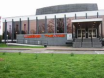
since 1965. It is the location of Queen's Theatre
and Havering Sixth Form College
.
Hornchurch is an Anglicised version of the Latin
Monasterium Cornutum, a term that was also applied to the mother Abbey in Savoy. The earliest recorded use here was in 1222, meaning 'church with horn-like gables' and it was recorded as Hornechurch in 1233. The horned bull's head mounted on the eastern end of St Andrew's Church
, near the town centre dates from much later; around the 18th Century.
tools, Bronze age
and Iron age
artefacts have been discovered in Hornchurch, indicating a lengthy occupation in pre-history. Roman remains, sufficient to indicate a settlement have also been found in South Hornchurch. Hornchurch originates from around the 12th century when Henry II
gave 1500 acres (6.1 km²) to the hospice of St Nicholas and St Bernard, Mountjoux, in Savoy
as a gift. A prosperous priory and church were established in Hornchurch, near the parish church, but the monks were forced out during the 14th century when a new law banned foreign land ownership. The lands were then given to Lord Chancellor William of Wykeham
who made major renovations to the church. He subsequently gave Hornchurch to endow New College, Oxford
, which still owns all the local church lands and buildings. Due to this, Saint Andrew's church was not adopted into the Diocese of Chelmsford
until agreement was reached in the 1930s. The parish remains staffed by a Vicar temporal and his curates.
, with Hornchurch village - then known as Suttons Manor, located in the south of the area. From the time of Edward the Confessor
, the land was in Royal ownership - passing to William the Conqueror at the conquest. In 1086, the name Havering was applied to the entire district. Hornchurch Urban District
was formed in 1926 from part of Romford Rural District. In 1934 it was enlarged to include Upminster
, Cranham
, and North Ockendon
although none are today considered part of Hornchurch. The council offices were located at Langtons
until 1965 when the present-day London Borough of Havering
was formed.
 During World War I
and World War II
nearby Hornchurch Airfield was an important RAF
station; it was known as RAF Suttons Farm during WWI, with its HQ as far away as Upminster Hall. During WWII, the airfield was known as RAF Hornchurch, and was home mostly to a number of Spitfire
squadrons, with an advanced sub-station at Rayleigh. The land has since been reused for a large housing development and Hornchurch Country Park
. Like most suburbs of London, Hornchurch had been entirely rural until the arrival of the railway which spurred huge property development during the early 1900s. Whole estates were constructed such as Emerson Park
to the north. Development was fuelled further by the arrival of the electrified District Line
during the 1930s with inter and post war housing developments south and west of Hornchurch in places such as Elm Park
.
UK Parliament constituency.
forms the boundary with Upminster
to the east. Hornchurch borders Romford
to the north west and Rainham
to the south.
as a local district centre with 31000 sqm of commercial floorspace. It is not considered a significant commercial office location. Within Havering, it is identified as one of seven town centres in the borough, with a retail area extending along High Street, North Street and Station Lane.
is located just within its eastern boundary, Hornchurch tube station
is located about a half-mile south of the high street, Elm Park tube station
is about a mile and a half to the south west and Emerson Park railway station
is located about a half-mile to the north. The nearest main line railway station is at Upminster
.
Hornchurch is served by the following Transport for London
contracted London Bus
routes: 165
, 193, 248
, 252, 256, 365, 370 and 372
.
are the local football team, formed to replace Hornchurch F.C.
with Havering Hockey Club
(formerly Hornchurch Hockey Club) accommodating the field hockey fixtures from their Harrow Lodge Park base.
In terms of top level sport, West Ham United are considered the local side due to the club's proximity to Hornchurch and the ease of reaching Upton Park on the District Line.
Hornchurch Drum & Trumpet Corps Boys marching band formed in 1959 and perform all over the country. They were the first winners of the National British Marching Band Championships in 1976 and performed at the Edinburgh Tattoo in 1977.
London Borough of Havering
The London Borough of Havering is a London borough in North East London, England and forms part of Outer London. The principal town in Havering is Romford and the other main communities are Hornchurch, Upminster and Rainham. The borough is mainly characterised by suburban development with large...
. Hornchurch is in North-East London .It is located 15.2 miles (24.5 km) east-northeast of Charing Cross
Charing Cross
Charing Cross denotes the junction of Strand, Whitehall and Cockspur Street, just south of Trafalgar Square in central London, England. It is named after the now demolished Eleanor cross that stood there, in what was once the hamlet of Charing. The site of the cross is now occupied by an equestrian...
and is one of the locally important district centres identified in the London Plan
London Plan
The London Plan is a planning document written by the Mayor of London, England in the United Kingdom and published by the Greater London Authority. The plan was first published in final form on 10 February 2004 and has since been amended. The current version was published in February 2008...
. It comprises a number of shopping streets and a large residential area. It historically formed a large ancient parish in the county of Essex
Essex
Essex is a ceremonial and non-metropolitan county in the East region of England, and one of the home counties. It is located to the northeast of Greater London. It borders with Cambridgeshire and Suffolk to the north, Hertfordshire to the west, Kent to the South and London to the south west...
that became the liberty of Havering
Royal Liberty of Havering
Havering, also known as Havering-atte-Bower, was a royal manor and ancient liberty whose former area now forms part of, and gives its name to, the London Borough of Havering in Greater London...
. The economic history of Hornchurch is underpinned by a shift away from agriculture to other industries and the growing significance of nearby Romford
Romford
Romford is a large suburban town in north east London, England and the administrative headquarters of the London Borough of Havering. It is located northeast of Charing Cross and is one of the major metropolitan centres identified in the London Plan...
as a market town
Market town
Market town or market right is a legal term, originating in the medieval period, for a European settlement that has the right to host markets, distinguishing it from a village and city...
and centre of administration. As part of the suburban growth of London in the 20th century, Hornchurch significantly expanded and increased in population, becoming an urban district
Hornchurch Urban District
Hornchurch was a local government district in south west Essex, England from 1926 to 1965. The urban district council was based at Langtons House. The district formed a suburb of London and was expanded in 1934...
in 1926 and has formed part of Greater London
Greater London
Greater London is the top-level administrative division of England covering London. It was created in 1965 and spans the City of London, including Middle Temple and Inner Temple, and the 32 London boroughs. This territory is coterminate with the London Government Office Region and the London...
since 1965. It is the location of Queen's Theatre
Queen's Theatre, Hornchurch
The Queen's Theatre, Hornchurch is a 500-seat theatre located in Hornchurch in the London Borough of Havering, east London.The theatre opened in its current purpose-built site on Billet Lane, Hornchurch in 1975....
and Havering Sixth Form College
Havering Sixth Form College
Havering Sixth Form College , abbreviated as HSFC, is a sixth form college in Wingletye Lane, Hornchurch in the London Borough of Havering, East London, England. Built on the site of Dury Falls Secondary School, it opened in September 1991, and educates full-time students from the ages of 16 to 19...
.
Toponomy
| 1881 | 2,824 |
|---|---|
| 1891 | 3,841 |
| 1901 | 6,402 |
| 1911 | 9,461 |
| 1921 | 10,891 |
| 1931 | 28,417 |
| 1941 | war # |
| 1951 | 79,908 |
| 1961 | 131,014 |
| # no census was held due to war | |
| source: UK census | |
Hornchurch is an Anglicised version of the Latin
Latin
Latin is an Italic language originally spoken in Latium and Ancient Rome. It, along with most European languages, is a descendant of the ancient Proto-Indo-European language. Although it is considered a dead language, a number of scholars and members of the Christian clergy speak it fluently, and...
Monasterium Cornutum, a term that was also applied to the mother Abbey in Savoy. The earliest recorded use here was in 1222, meaning 'church with horn-like gables' and it was recorded as Hornechurch in 1233. The horned bull's head mounted on the eastern end of St Andrew's Church
St Andrew's Church, Hornchurch
The church of St Andrew's, Hornchurch is a Church of England religious building in Hornchurch, England.-History:There has been a church on this site since at least 1163. The tower and the north porch were added in the 15th century.-Interments:...
, near the town centre dates from much later; around the 18th Century.
Origins
Stone AgeStone Age
The Stone Age is a broad prehistoric period, lasting about 2.5 million years , during which humans and their predecessor species in the genus Homo, as well as the earlier partly contemporary genera Australopithecus and Paranthropus, widely used exclusively stone as their hard material in the...
tools, Bronze age
Bronze Age
The Bronze Age is a period characterized by the use of copper and its alloy bronze as the chief hard materials in the manufacture of some implements and weapons. Chronologically, it stands between the Stone Age and Iron Age...
and Iron age
Iron Age
The Iron Age is the archaeological period generally occurring after the Bronze Age, marked by the prevalent use of iron. The early period of the age is characterized by the widespread use of iron or steel. The adoption of such material coincided with other changes in society, including differing...
artefacts have been discovered in Hornchurch, indicating a lengthy occupation in pre-history. Roman remains, sufficient to indicate a settlement have also been found in South Hornchurch. Hornchurch originates from around the 12th century when Henry II
Henry II of England
Henry II ruled as King of England , Count of Anjou, Count of Maine, Duke of Normandy, Duke of Aquitaine, Duke of Gascony, Count of Nantes, Lord of Ireland and, at various times, controlled parts of Wales, Scotland and western France. Henry, the great-grandson of William the Conqueror, was the...
gave 1500 acres (6.1 km²) to the hospice of St Nicholas and St Bernard, Mountjoux, in Savoy
Savoy
Savoy is a region of France. It comprises roughly the territory of the Western Alps situated between Lake Geneva in the north and Monaco and the Mediterranean coast in the south....
as a gift. A prosperous priory and church were established in Hornchurch, near the parish church, but the monks were forced out during the 14th century when a new law banned foreign land ownership. The lands were then given to Lord Chancellor William of Wykeham
William of Wykeham
William of Wykeham was Bishop of Winchester, Chancellor of England, founder of Winchester College, New College, Oxford, New College School, Oxford, and builder of a large part of Windsor Castle.-Life:...
who made major renovations to the church. He subsequently gave Hornchurch to endow New College, Oxford
New College, Oxford
New College is one of the constituent colleges of the University of Oxford in the United Kingdom.- Overview :The College's official name, College of St Mary, is the same as that of the older Oriel College; hence, it has been referred to as the "New College of St Mary", and is now almost always...
, which still owns all the local church lands and buildings. Due to this, Saint Andrew's church was not adopted into the Diocese of Chelmsford
Diocese of Chelmsford
The Diocese of Chelmsford is a Church of England diocese, part of the Province of Canterbury. The diocese covers Essex and the five East London boroughs of Barking and Dagenham, Havering, Newham, Redbridge, and Waltham Forest, and is co-terminous with the boundaries of the Catholic Diocese of...
until agreement was reached in the 1930s. The parish remains staffed by a Vicar temporal and his curates.
Local government
Historically, the parish was conterminous with the Royal Manor and Liberty of Havering-atte-BowerRoyal Liberty of Havering
Havering, also known as Havering-atte-Bower, was a royal manor and ancient liberty whose former area now forms part of, and gives its name to, the London Borough of Havering in Greater London...
, with Hornchurch village - then known as Suttons Manor, located in the south of the area. From the time of Edward the Confessor
Edward the Confessor
Edward the Confessor also known as St. Edward the Confessor , son of Æthelred the Unready and Emma of Normandy, was one of the last Anglo-Saxon kings of England and is usually regarded as the last king of the House of Wessex, ruling from 1042 to 1066....
, the land was in Royal ownership - passing to William the Conqueror at the conquest. In 1086, the name Havering was applied to the entire district. Hornchurch Urban District
Hornchurch Urban District
Hornchurch was a local government district in south west Essex, England from 1926 to 1965. The urban district council was based at Langtons House. The district formed a suburb of London and was expanded in 1934...
was formed in 1926 from part of Romford Rural District. In 1934 it was enlarged to include Upminster
Upminster
Upminster is a suburban town in northeast London, England, and part of the London Borough of Havering. Located east-northeast of Charing Cross, it is one of the locally important district centres identified in the London Plan, and comprises a number of shopping streets and a large residential...
, Cranham
Cranham
Cranham is a residential suburb in northeast London, England and part of the London Borough of Havering. It is located east-northeast of Charing Cross and comprises an extensive built-up area to the north and a low density conservation area surrounded by open land to the south. It was historically...
, and North Ockendon
North Ockendon
North Ockendon is an outlying settlement of northeast London, England and part of the London Borough of Havering. It is located east northeast of Charing Cross and consists of a dispersed settlement within the Metropolitan Green Belt...
although none are today considered part of Hornchurch. The council offices were located at Langtons
Langtons
Langtons is a grade II listed 18th-century house and gardens open to the public situated in Hornchurch in the London Borough of Havering, east London....
until 1965 when the present-day London Borough of Havering
London Borough of Havering
The London Borough of Havering is a London borough in North East London, England and forms part of Outer London. The principal town in Havering is Romford and the other main communities are Hornchurch, Upminster and Rainham. The borough is mainly characterised by suburban development with large...
was formed.
Modern history
World War I
World War I , which was predominantly called the World War or the Great War from its occurrence until 1939, and the First World War or World War I thereafter, was a major war centred in Europe that began on 28 July 1914 and lasted until 11 November 1918...
and World War II
World War II
World War II, or the Second World War , was a global conflict lasting from 1939 to 1945, involving most of the world's nations—including all of the great powers—eventually forming two opposing military alliances: the Allies and the Axis...
nearby Hornchurch Airfield was an important RAF
Royal Air Force
The Royal Air Force is the aerial warfare service branch of the British Armed Forces. Formed on 1 April 1918, it is the oldest independent air force in the world...
station; it was known as RAF Suttons Farm during WWI, with its HQ as far away as Upminster Hall. During WWII, the airfield was known as RAF Hornchurch, and was home mostly to a number of Spitfire
Supermarine Spitfire
The Supermarine Spitfire is a British single-seat fighter aircraft that was used by the Royal Air Force and many other Allied countries throughout the Second World War. The Spitfire continued to be used as a front line fighter and in secondary roles into the 1950s...
squadrons, with an advanced sub-station at Rayleigh. The land has since been reused for a large housing development and Hornchurch Country Park
Hornchurch Country Park
Hornchurch Country Park is a park on the former site of Hornchurch Airfield, south of Hornchurch in the London Borough of Havering, east London.The River Ingrebourne passes through the park and if forms part of Thames Chase Community Forest...
. Like most suburbs of London, Hornchurch had been entirely rural until the arrival of the railway which spurred huge property development during the early 1900s. Whole estates were constructed such as Emerson Park
Emerson Park
Emerson Park is a suburban development in the London Borough of Havering, east London, England. It is a principally residential district located east-northeast of Charing Cross.-Housing:...
to the north. Development was fuelled further by the arrival of the electrified District Line
District Line
The District line is a line of the London Underground, coloured green on the Tube map. It is a "sub-surface" line, running through the central area in shallow cut-and-cover tunnels. It is the busiest of the sub-surface lines. Out of the 60 stations served, 25 are underground...
during the 1930s with inter and post war housing developments south and west of Hornchurch in places such as Elm Park
Elm Park
Elm Park is a place in the London Borough of Havering, in east London, England. It is a suburban development situated east north-east of Charing Cross. Unlike the nearby suburbs of Upminster and Hornchurch, Elm Park was not developed until after the arrival of the electrified District Line in 1935...
.
Governance
The town forms part of the HornchurchHornchurch (UK Parliament constituency)
Hornchurch was a borough constituency represented in the House of Commons of the Parliament of the United Kingdom. It elected one Member of Parliament by the first past the post system of election...
UK Parliament constituency.
Geography
The River IngrebourneRiver Ingrebourne
The River Ingrebourne, 27 miles in length, is a tributary of the River Thames. It is considered a strategic waterway in London, forming part of the Blue Ribbon Network...
forms the boundary with Upminster
Upminster
Upminster is a suburban town in northeast London, England, and part of the London Borough of Havering. Located east-northeast of Charing Cross, it is one of the locally important district centres identified in the London Plan, and comprises a number of shopping streets and a large residential...
to the east. Hornchurch borders Romford
Romford
Romford is a large suburban town in north east London, England and the administrative headquarters of the London Borough of Havering. It is located northeast of Charing Cross and is one of the major metropolitan centres identified in the London Plan...
to the north west and Rainham
Rainham, London
Rainham is a suburban town in northeast London, England, and part of the London Borough of Havering. Located east of Charing Cross, it is one of the locally important district centres identified in the London Plan and is surrounded by a residential area, which has grown from the historic village,...
to the south.
Demography
The Havering committee area for Hornchurch is defined as the wards of Hacton and St Andrew's.Economy
Hornchurch is identified in the London PlanLondon Plan
The London Plan is a planning document written by the Mayor of London, England in the United Kingdom and published by the Greater London Authority. The plan was first published in final form on 10 February 2004 and has since been amended. The current version was published in February 2008...
as a local district centre with 31000 sqm of commercial floorspace. It is not considered a significant commercial office location. Within Havering, it is identified as one of seven town centres in the borough, with a retail area extending along High Street, North Street and Station Lane.
Transport
There are no stations in central Hornchurch, however four stations are located within the town; Upminster Bridge tube stationUpminster Bridge tube station
Upminster Bridge tube station is a London Underground station on Upminster Road in the Upminster Bridge neighbourhood of the London Borough of Havering in northeast London, England. The station is on the District line and is the penultimate station on the eastern extremity of that line...
is located just within its eastern boundary, Hornchurch tube station
Hornchurch tube station
Hornchurch tube station is a London Underground station on the District Line, located in Hornchurch and a short walk south from the town centre. The station is in Zone 6, located between Elm Park and Upminster Bridge stations.-History:...
is located about a half-mile south of the high street, Elm Park tube station
Elm Park tube station
Elm Park Station is a London Underground station on the District Line, located in Elm Park in the London Borough of Havering.The station is in Zone 6...
is about a mile and a half to the south west and Emerson Park railway station
Emerson Park railway station
Emerson Park railway station is a National Rail station on Butts Green Road in the Emerson Park neighbourhood of the London Borough of Havering in northeast London, England. The station is on the Romford to Upminster Line and is the only intermediate station of that line...
is located about a half-mile to the north. The nearest main line railway station is at Upminster
Upminster station
Upminster station is a London Underground and National Rail station located in Upminster in the London Borough of Havering and in London fare zone 6. Located east-northeast of Charing Cross, it is the easternmost station on the London Underground network and the eastern terminus of the District...
.
Hornchurch is served by the following Transport for London
Transport for London
Transport for London is the local government body responsible for most aspects of the transport system in Greater London in England. Its role is to implement the transport strategy and to manage transport services across London...
contracted London Bus
London Buses
London Buses is the subsidiary of Transport for London that manages bus services within Greater London, UK. Buses are required to carry similar red colour schemes and conform to the same fare scheme...
routes: 165
London Buses route 165
London Buses route 165 is a Transport for London contracted bus route in London, England. The service is currently contracted to First Capital.-History:...
, 193, 248
London Buses route 248
London Buses route 248 is a Transport for London contracted bus route in London, United Kingdom. The service is currently contracted to Stagecoach London.-History:...
, 252, 256, 365, 370 and 372
London Buses route 372
London Buses route 372 is a Transport for London contracted bus route in London, United Kingdom. The service is currently contracted to Stagecoach London...
.
Culture
A.F.C. HornchurchA.F.C. Hornchurch
AFC Hornchurch are an English football club based in Hornchurch, Greater London. The club are currently members of the Isthmian League Premier Division and play at the Hornchurch Stadium....
are the local football team, formed to replace Hornchurch F.C.
Hornchurch F.C.
Hornchurch F.C. were an non-League football club based in east London. They played in the Conference South, after being promoted from the Isthmian League....
with Havering Hockey Club
Havering Hockey Club
Havering Hockey Club is a field hockey club based in Hornchurch which is in the London Borough of Havering, east London, England. The club consists of 4 Mens teams and 4 Ladies teams playing at varying levels....
(formerly Hornchurch Hockey Club) accommodating the field hockey fixtures from their Harrow Lodge Park base.
In terms of top level sport, West Ham United are considered the local side due to the club's proximity to Hornchurch and the ease of reaching Upton Park on the District Line.
Hornchurch Drum & Trumpet Corps Boys marching band formed in 1959 and perform all over the country. They were the first winners of the National British Marching Band Championships in 1976 and performed at the Edinburgh Tattoo in 1977.