

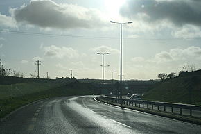
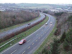
High-quality dual carriageway
Encyclopedia
Republic of Ireland
Ireland , described as the Republic of Ireland , is a sovereign state in Europe occupying approximately five-sixths of the island of the same name. Its capital is Dublin. Ireland, which had a population of 4.58 million in 2011, is a constitutional republic governed as a parliamentary democracy,...
. It is an all-purpose dual carriageway
Dual carriageway
A dual carriageway is a class of highway with two carriageways for traffic travelling in opposite directions separated by a central reservation...
road type built to near motorway standards, but without motorway classification or motorway restrictions. High-quality dual carriageways have full grade-separated access and do not have junctions with minor roads. Such roads in the Republic of Ireland have been built as part of the 2000-2006 and 2007 to 2013 National Development Plan
National Development Plan
National Development Plan is the title given by the Irish Government to a scheme of organised large-scale expenditure on national infrastructure. The period covered by the seven year plan runs from 2000 to 2006. A second National Development Plan is currently in progress and is due to run until...
s, including interurban routes from Dublin to other cities.
While HQDCs or roads of similar type exist in a number of countries (a British example being the A55 road
A55 road
The A55, also known as the North Wales Expressway, is a major road in Britain. Its entire length is a dual carriageway primary route, with the exception of the point where it crosses the Britannia Bridge over the Menai Strait. All junctions are grade separated except for two roundabouts — one...
in Wales
Wales
Wales is a country that is part of the United Kingdom and the island of Great Britain, bordered by England to its east and the Atlantic Ocean and Irish Sea to its west. It has a population of three million, and a total area of 20,779 km²...
), this article concentrates mainly on such roads in the Republic of Ireland.
Specifications
Standard motorways: 52,000 vehicles AADT - annual average daily traffic. The road type is all-purpose dual carriageway (D2AP), but with the same specifications as motorway: a carriagewayCarriageway
A carriageway consists of a width of road on which a vehicle is not restricted by any physical barriers or separation to move laterally...
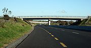
width of 7 metres (23 ft) and a hard shoulder of 2.5 metres (8 ft 2 in) width. HQDCs are limited access (grade-separated junctions only) and not intended to have junctions with minor roads. Junctions with major roads are grade-separated and to motorway standards.
All HQDCs in Ireland
Ireland
Ireland is an island to the northwest of continental Europe. It is the third-largest island in Europe and the twentieth-largest island on Earth...
currently form part of national primary road
National primary road
A national primary road is a road classification in the Republic of Ireland. National primary roads form the major routes between the major urban centres. There are over 2,700km of national primary roads. This category of road has the prefix "N" followed by one or two digits...
s, and therefore use the national road speed limit
Road speed limits in the Republic of Ireland
Road speed limits in the Republic of Ireland apply on all public roads in the country. These are signposted and legislated for in kilometres per hour. Speed limits are demarcated by regulatory road signs . These consist of white circular signs with a red outline. Speed limits are marked in black...
of 100 km/h (62 mph). There are exceptions however, as special speed limits may now be specified for sections of road if the local authority passes a by-law. For example, a section of the N1 from the northern end of the M1 motorway (north of Dundalk
Dundalk
Dundalk is the county town of County Louth in Ireland. It is situated where the Castletown River flows into Dundalk Bay. The town is close to the border with Northern Ireland and equi-distant from Dublin and Belfast. The town's name, which was historically written as Dundalgan, has associations...
to the border with Northern Ireland
Northern Ireland
Northern Ireland is one of the four countries of the United Kingdom. Situated in the north-east of the island of Ireland, it shares a border with the Republic of Ireland to the south and west...
) has a 120 km/h (75 mph) speed limit.
Signage on Irish HQDCs is similar to signage used on Irish motorways, and junction numbers may be present (as on motorways, indicated by a white number on a black panel in the corner of signs). However signage on HQDCs uses a green background instead of the blue background used on Irish motorway signage. In the event of an HQDC being a regional road
Regional road
A regional road in Ireland is a class of road not forming a major route , but nevertheless forming a link in the national route network. There are over 11,600 kilometres of regional roads. Regional roads are numbered with three digit route numbers, prefixed by "R" A regional road in Ireland is a...
, black text on a white background would be used instead. Also, as on other all-purpose roads, signs should include patches
Road signs in the Republic of Ireland
Road signs in Ireland mostly differ from the traffic signs used elsewhere in Europe. Directional signage is similar to that of the United Kingdom, but is bilingual. Distances are in kilometres. Apart from directional signage, the basic prohibitory signs such as "no left turn" and "no right turn"...
for roads of other classifications (on motorways, all information signage should have a blue background).
As high-quality dual carriageways are not motorways, they do not need to conform to motorway regulations, therefore slow-moving vehicles (e.g. tractors, farm vehicles etc.) as well as cyclists are permitted to use these roads. HQDCs have a hard shoulder marked with a broken yellow line (as is standard on Irish roads), rather than the solid yellow line used to mark the hard shoulder of an Irish motorway. Also, L-Drivers (Learner Drivers
Driving licence in the Republic of Ireland
A driving licence issued by the Department of Transport Tourism and Sport through a Principal Local Authority is required to drive most forms of motorized vehicles in public in the state...
), who are not permitted to drive on motorways can do so on high-quality dual carriageways, as on the rest of the national road network. HQDCs are a road type, not a classification, and the normal rules and regulations applying to all-purpose roads apply on HQDCs.
Lay-bys
Rest area
A rest area, travel plaza, rest stop, or service area is a public facility, located next to a large thoroughfare such as a highway, expressway, or freeway at which drivers and passengers can rest, eat, or refuel without exiting on to secondary roads...
(rest stops) are permitted on HQDCs and the N6/M6 Kinnegad
Kinnegad
Kinnegad or Kinagad is a town in County Westmeath, Ireland. It is near the border with County Meath, at the junction of the N6 and the N4 - two of Ireland's main east-west roads...
- Kilbeggan
Kilbeggan
-Geography:Kilbeggan is situated on the River Brosna, in the south of County Westmeath. It lies southeast of Lough Ennell, north of the boundary with County Offaly, about 9 kilometres north of Tullamore. Kilbeggan is surrounded by the gently rolling Esker Riada, the linear sand hills that stretch...
scheme originally featured lay-bys, which would not be legal at present on roads with full motorway status, prior to its redesignation as a motorway. The M9
M9 motorway (Ireland)
The M9 motorway is a motorway in Ireland linking the M7 at Kilcullen to Waterford. Opened in sections between 1994 and 2010, the final section opened on 9 September 2010....
Carlow
Carlow
Carlow is the county town of County Carlow in Ireland. It is situated in the south-east of Ireland, 84 km from Dublin. County Carlow is the second smallest county in Ireland by area, however Carlow Town is the 14th largest urban area in Ireland by population according to the 2006 census. The...
bypass was built with lay-bys as it was originally to be built as an HQDC section of the N9 route. The lay-bys were removed after the road was reclassified as a motorway. Lay-bys on other HQDCs which were reclassified as motorways were restricted to authorised vehicles only and are likely to be used mainly by Garda Síochána
Garda Síochána
, more commonly referred to as the Gardaí , is the police force of Ireland. The service is headed by the Commissioner who is appointed by the Irish Government. Its headquarters are located in the Phoenix Park in Dublin.- Terminology :...
(police) patrol vehicles.
High Quality Dual Carriageways with Motorway Speed Limits in the Republic of Ireland
The standard speed limit for cars on Irish motorways is 120 km/h (with a minimum speed limit for any type of vehicle of 50 km/h - 31 mph). The standard speed limit on national roads is 100 km/h (62 mph). A number of local authorities have passed special speed limit by-laws permitting dual carriageways in their administrative area to carry motorway speed limits of 120 km/h (75 mph).| Route | Section | Counties | Destinations | Officially Introduced |
|---|---|---|---|---|
| N1 | North of Dundalk Dundalk Dundalk is the county town of County Louth in Ireland. It is situated where the Castletown River flows into Dundalk Bay. The town is close to the border with Northern Ireland and equi-distant from Dublin and Belfast. The town's name, which was historically written as Dundalgan, has associations... to Northern Ireland border |
Louth | (Dublin) – Belfast Belfast Belfast is the capital of and largest city in Northern Ireland. By population, it is the 14th biggest city in the United Kingdom and second biggest on the island of Ireland . It is the seat of the devolved government and legislative Northern Ireland Assembly... |
15 August 2007 |
| N22 | Bandon Road Roundabout to Ovens | County Cork County Cork County Cork is a county in Ireland. It is located in the South-West Region and is also part of the province of Munster. It is named after the city of Cork . Cork County Council is the local authority for the county... |
Cork Cork (city) Cork is the second largest city in the Republic of Ireland and the island of Ireland's third most populous city. It is the principal city and administrative centre of County Cork and the largest city in the province of Munster. Cork has a population of 119,418, while the addition of the suburban... - Killarney Killarney Killarney is a town in County Kerry, southwestern Ireland. The town is located north of the MacGillicuddy Reeks, on the northeastern shore of the Lough Lein/Leane which are part of Killarney National Park. The town and its surrounding region are home to St... |
|
| N25 | Dunkettle to Carrigtwohill Carrigtwohill Carrigtwohill, officially Carrigtohill , is a village in County Cork, Province of Munster, Ireland with a population of 4,869 . It is located east of Cork city, bypassed by the N25 road and is part of Metropolitan Cork. Carrigtwohill is one of the fastest growing towns in Ireland. It is a major... |
County Cork County Cork County Cork is a county in Ireland. It is located in the South-West Region and is also part of the province of Munster. It is named after the city of Cork . Cork County Council is the local authority for the county... |
Cork Cork (city) Cork is the second largest city in the Republic of Ireland and the island of Ireland's third most populous city. It is the principal city and administrative centre of County Cork and the largest city in the province of Munster. Cork has a population of 119,418, while the addition of the suburban... - Waterford Waterford Waterford is a city in the South-East Region of Ireland. It is the oldest city in the country and fifth largest by population. Waterford City Council is the local government authority for the city and its immediate hinterland... |
HQDCs on Major Inter-Urban Routes
M8 motorway (Ireland)
The M8 motorway is an inter-urban motorway in Ireland, which forms part of the road from the capital - Dublin - to Cork city. The 149 km motorway commences in the townland of Aghaboe, County Laois and runs through the counties of Kilkenny, North Tipperary, South Tipperary and Limerick,...
Mitchelstown
Mitchelstown
Mitchelstown is a town in County Cork, Ireland with a population of approximately 3300. Mitchelstown is situated in the valley to the south of the Galtee Mountains close to the Mitchelstown Caves and is 28 km from Cahir, 50 km from Cork and 59 km from Limerick...
- Cashel
Cashel, County Tipperary
Cashel is a town in South Tipperary in Ireland. Its population was 2936 at the 2006 census. The town gives its name to the ecclesiastical province of Cashel. Additionally, the cathedra of the Roman Catholic Archdiocese of Cashel and Emly was originally in the town prior to the English Reformation....
scheme (completed in October 2008) and the M9
M9 motorway (Ireland)
The M9 motorway is a motorway in Ireland linking the M7 at Kilcullen to Waterford. Opened in sections between 1994 and 2010, the final section opened on 9 September 2010....
Carlow bypass scheme (completed in June 2008). These roads will form part of the major inter-urban routes network. The advantage of an HQDC over a motorway in this regard is that a simpler planning permission process is used, rather than the more complex Motorway Scheme process used to create a motorway. However the problem of using the normal planning process is that in theory planning permission could be granted for a direct access for a home or business onto the HQDC; although such direct accesses are now discouraged under public policy there is no legal impediment. Motorways, by contrast, may only have accesses at junctions and service areas. HQDCs which form part of national road routes use the N (national road) prefix on signage as opposed to the M prefix used where the route or a section of it is motorway.
Most of the HQDC sections (both completed and under construction) on the major inter-urban network of roads in Ireland have recently been redesignated as motorways or have been proposed for redesignation.
Redesignation as motorway
In 2007 new legislation was introduced to allow the Government to designate HQDCs as motorways and thus avoid the risk of permission for direct access being granted by local planning authorities. The Roads Act 2007 was passed by the OireachtasOireachtas
The Oireachtas , sometimes referred to as Oireachtas Éireann, is the "national parliament" or legislature of Ireland. The Oireachtas consists of:*The President of Ireland*The two Houses of the Oireachtas :**Dáil Éireann...
in early 2007 and signed into law to by the President of Ireland
President of Ireland
The President of Ireland is the head of state of Ireland. The President is usually directly elected by the people for seven years, and can be elected for a maximum of two terms. The presidency is largely a ceremonial office, but the President does exercise certain limited powers with absolute...
on 11 July 2007. The Act introduced powers for the Minister for Transport
Minister for Transport (Ireland)
The Minister for Transport, Tourism and Sport is the senior minister at the Department of Transport, Tourism and Sport in the Government of Ireland.The current Minister for Transport, Tourism and Sport is Leo Varadkar, TD...
(on the recommendation of the National Roads Authority
National Roads Authority
The National Roads Authority is a state body in the Republic of Ireland, responsible for the national road network. The NRA was established as part of the Roads Act 1993 and commenced operations on 23 December 1993 in accordance with S.I. 407 of 1993.County councils remain responsible for local...
) to re-designate high quality dual carriageways as motorways, following a public consultation process. It is possible that in the future a majority of HQDCs will be reclassified as motorways.
A number of the former high-quality dual carriageway schemes proceeded as tolled motorway PPPs (Public Private Partnerships) despite not being originally planned as motorway schemes. Such roads include the M6 Galway
Galway
Galway or City of Galway is a city in County Galway, Republic of Ireland. It is the sixth largest and the fastest-growing city in Ireland. It is also the third largest city within the Republic and the only city in the Province of Connacht. Located on the west coast of Ireland, it sits on the...
- Ballinasloe project. The N25
N25 road
The N25 road is a national primary road in Ireland, forming the route from Cork to Rosslare Europort via Waterford City. The road is part of the E30 European route and a short section is also part of the E01 European route...
Waterford
Waterford
Waterford is a city in the South-East Region of Ireland. It is the oldest city in the country and fifth largest by population. Waterford City Council is the local government authority for the city and its immediate hinterland...
City bypass is the only HQDC planned at present to be tolled. Almost all other Irish toll roads are motorways, although the East-Link
East-Link (Dublin)
The East-Link is a toll bridge in Dublin, Ireland, on the River Liffey, owned by Dublin City Council and operated by NTR plc. The lifting bridge, which links North Wall to Ringsend, is the last bridge on the Liffey, which opens out into Dublin Port and then Dublin Bay just beyond...
toll bridge which is a regional road
Regional road
A regional road in Ireland is a class of road not forming a major route , but nevertheless forming a link in the national route network. There are over 11,600 kilometres of regional roads. Regional roads are numbered with three digit route numbers, prefixed by "R" A regional road in Ireland is a...
is also tolled.
| Route | Proposed motorway section | Destinations |
|---|---|---|
| N6 road | Kinnegad (M6 J2) – Athlone | (Dublin) – Galway Galway Galway or City of Galway is a city in County Galway, Republic of Ireland. It is the sixth largest and the fastest-growing city in Ireland. It is also the third largest city within the Republic and the only city in the Province of Connacht. Located on the west coast of Ireland, it sits on the... |
| N7 road | South of Borris-in-Ossory Borris-in-Ossory Borris-in-Ossory is a village in west County Laois, Ireland. Bypassed by the M7 motorway on 28 May, 2010, the village is situated on the R445 road close to the County Tipperary border between the towns of Mountrath and Roscrea.-Features:... to Annacotty Annacotty Annacotty is a town on the outskirts of Limerick, Ireland, from the centre of the city. It is situated where the old N7 main road between Limerick and Dublin crosses the Mulkear River, upstream of where it flows into the River Shannon.... |
Dublin – Limerick Limerick Limerick is the third largest city in the Republic of Ireland, and the principal city of County Limerick and Ireland's Mid-West Region. It is the fifth most populous city in all of Ireland. When taking the extra-municipal suburbs into account, Limerick is the third largest conurbation in the... |
| N8 road | Urlingford Urlingford Urlingford is a town in the barony of Galmoy, County Kilkenny, Ireland.The town lies on the R639. The M8 motorway runs just west of the town, from which both Urlingford and nearby Johnstown are accessed via junction four. Urlingford is a bus hub, with major operator JJ Kavanagh and Sons based there... – Fermoy Fermoy Fermoy is a town in County Cork, Ireland. It is situated on the River Blackwater in the south of Ireland. Its population is some 5,800 inhabitants, environs included .... |
(Dublin) – Cork Cork (city) Cork is the second largest city in the Republic of Ireland and the island of Ireland's third most populous city. It is the principal city and administrative centre of County Cork and the largest city in the province of Munster. Cork has a population of 119,418, while the addition of the suburban... |
| N9 road | Kilcullen Kilcullen Kilcullen , formally Kilcullen Bridge, is a small town on the River Liffey in County Kildare, Ireland. Its population of 2,985 makes it the 12th largest settlement in County Kildare and the fastest growing in the county, having doubled in population from 1,483 in the census of 2002... – Waterford Waterford Waterford is a city in the South-East Region of Ireland. It is the oldest city in the country and fifth largest by population. Waterford City Council is the local government authority for the city and its immediate hinterland... (junction with proposed N25 road N25 road The N25 road is a national primary road in Ireland, forming the route from Cork to Rosslare Europort via Waterford City. The road is part of the E30 European route and a short section is also part of the E01 European route... ) |
(Dublin) – Waterford Waterford Waterford is a city in the South-East Region of Ireland. It is the oldest city in the country and fifth largest by population. Waterford City Council is the local government authority for the city and its immediate hinterland... |
The consultation procession lasted until 28 March 2008. On 17 July 2008 the Minister signed a statutory instrument
Statutory Instrument
A Statutory Instrument is the principal form in which delegated or secondary legislation is made in Great Britain.Statutory Instruments are governed by the Statutory Instruments Act 1946. They replaced Statutory Rules and Orders, made under the Rules Publication Act 1893, in 1948.Most delegated...
reclassifying all the HQDCs then either under construction or recently completed on the N7/M7, and N8/M8 as well as parts of the N6/M6 and N9/M9 as motorway. The redesignations came into effect on September 24, 2008. The Carlow bypass and Kilbeggan-Athlone roads opened with motorway signage but with temporary 100 km/h (62 mph) general speed limits between their opening and their official re-designation as motorways. These roads now operate under motorway restrictions with motorway signage and use the M prefix. The standard speed limit on these roads is now 120 km/h (75 mph).
On 30 September 2008, the NRA proposed that the following dual-carriageways be re-designated as motorways:
| Route | Proposed motorway section | Destinations |
|---|---|---|
| N2 road | Junction 2 – north of Ashbourne | Dublin – Derry Derry Derry or Londonderry is the second-biggest city in Northern Ireland and the fourth-biggest city on the island of Ireland. The name Derry is an anglicisation of the Irish name Doire or Doire Cholmcille meaning "oak-wood of Colmcille"... |
| N3 road | Mulhuddart Mulhuddart Mulhuddart is a suburb situated to the north-west of Dublin city, in the barony of Castleknock, Ireland. The River Tolka passes near the village.-Location and access:The N3 dual carriageway now by-passes the village... – Dunboyne Dunboyne Dunboyne is a town in County Meath in Ireland. For the most part, it is a dormitory town for the city of Dublin.-Location:Dunboyne is centred on the crossroads formed by the R156 regional road and the old Maynooth Road .... |
Dublin – Ballyshannon Ballyshannon Ballyshannon is a town in County Donegal, Ireland. It is located where the N3 and N15 cross the River Erne, and claims to be the oldest town in Ireland.-Location:... |
| N4 road | Kinnegad Kinnegad Kinnegad or Kinagad is a town in County Westmeath, Ireland. It is near the border with County Meath, at the junction of the N6 and the N4 - two of Ireland's main east-west roads... – McNead's Bridge |
Dublin – Sligo Sligo Sligo is the county town of County Sligo in Ireland. The town is a borough and has a charter and a town mayor. It is sometimes referred to as a city, and sometimes as a town, and is the second largest urban area in Connacht... |
| N6 road | Athlone – Galway Galway Galway or City of Galway is a city in County Galway, Republic of Ireland. It is the sixth largest and the fastest-growing city in Ireland. It is also the third largest city within the Republic and the only city in the Province of Connacht. Located on the west coast of Ireland, it sits on the... |
(Dublin) – Galway Galway Galway or City of Galway is a city in County Galway, Republic of Ireland. It is the sixth largest and the fastest-growing city in Ireland. It is also the third largest city within the Republic and the only city in the Province of Connacht. Located on the west coast of Ireland, it sits on the... |
| N7 road | Annacotty Annacotty Annacotty is a town on the outskirts of Limerick, Ireland, from the centre of the city. It is situated where the old N7 main road between Limerick and Dublin crosses the Mulkear River, upstream of where it flows into the River Shannon.... – Limerick Limerick Limerick is the third largest city in the Republic of Ireland, and the principal city of County Limerick and Ireland's Mid-West Region. It is the fifth most populous city in all of Ireland. When taking the extra-municipal suburbs into account, Limerick is the third largest conurbation in the... |
Dublin – Limerick Limerick Limerick is the third largest city in the Republic of Ireland, and the principal city of County Limerick and Ireland's Mid-West Region. It is the fifth most populous city in all of Ireland. When taking the extra-municipal suburbs into account, Limerick is the third largest conurbation in the... |
| N8 road | Watergrasshill Watergrasshill Watergrasshill is a small town in County Cork, Province of Munster, Ireland. The 2006 census recorded a population of 1,068.Bypassed in 2003, the town is situated on the R639 road. It is accessible via junction 17 of the M8 motorway... – Cork Cork (city) Cork is the second largest city in the Republic of Ireland and the island of Ireland's third most populous city. It is the principal city and administrative centre of County Cork and the largest city in the province of Munster. Cork has a population of 119,418, while the addition of the suburban... |
(Dublin) – Cork Cork (city) Cork is the second largest city in the Republic of Ireland and the island of Ireland's third most populous city. It is the principal city and administrative centre of County Cork and the largest city in the province of Munster. Cork has a population of 119,418, while the addition of the suburban... |
| N11 road | Ashford Ashford, County Wicklow Ashford , historically known as Ballymacahara , is a village County Wicklow, Republic of Ireland. It lies on the R772 regional road. The Vartry River flows under the road in the village centre... – Rathnew Rathnew Rathnew is a village of County Wicklow, Ireland. Located south of the capital Dublin along the N11 between Dublin and Wexford, it is the exit point for those wishing to visit the county town of Wicklow, situated to the East.-Education:... and Arklow Arklow Arklow , also known as Inbhear Dé from the Avonmore river's older name Abhainn Dé, is a historic town located in County Wicklow on the east coast of Ireland. Founded by the Vikings in the ninth century, Arklow was the site of one of the bloodiest battles of the 1798 rebellion... – Gorey Gorey Gorey , is a market town in north County Wexford, Ireland, situated beside the main M11 Dublin to Wexford road. The town is also connected to the railway network along the same route. Local newspapers include the Gorey Guardian and Gorey Echo.... |
(Dublin) – Wexford Wexford Wexford is the county town of County Wexford, Ireland. It is situated near the southeastern corner of Ireland, close to Rosslare Europort. The town is connected to Dublin via the M11/N11 National Primary Route, and the national rail network... |
| N18 road | Ennis Ennis Ennis is the county town of Clare in Ireland. Situated on the River Fergus, it lies north of Limerick and south of Galway. Its name is a shortening of the original .... – Galway Galway Galway or City of Galway is a city in County Galway, Republic of Ireland. It is the sixth largest and the fastest-growing city in Ireland. It is also the third largest city within the Republic and the only city in the Province of Connacht. Located on the west coast of Ireland, it sits on the... |
Limerick Limerick Limerick is the third largest city in the Republic of Ireland, and the principal city of County Limerick and Ireland's Mid-West Region. It is the fifth most populous city in all of Ireland. When taking the extra-municipal suburbs into account, Limerick is the third largest conurbation in the... – Galway Galway Galway or City of Galway is a city in County Galway, Republic of Ireland. It is the sixth largest and the fastest-growing city in Ireland. It is also the third largest city within the Republic and the only city in the Province of Connacht. Located on the west coast of Ireland, it sits on the... |
| N20 road | Limerick Limerick Limerick is the third largest city in the Republic of Ireland, and the principal city of County Limerick and Ireland's Mid-West Region. It is the fifth most populous city in all of Ireland. When taking the extra-municipal suburbs into account, Limerick is the third largest conurbation in the... – Patrickswell Patrickswell Patrickswell, historically known as Toberpatrick , is a small town in County Limerick, Ireland.-Etymology:The name refers to St. Patrick and there is a small hand pump/well in the main street; Microsoft mappoint and some other programs call the village St. Patrick's Well or St.... |
Limerick Limerick Limerick is the third largest city in the Republic of Ireland, and the principal city of County Limerick and Ireland's Mid-West Region. It is the fifth most populous city in all of Ireland. When taking the extra-municipal suburbs into account, Limerick is the third largest conurbation in the... – Cork Cork (city) Cork is the second largest city in the Republic of Ireland and the island of Ireland's third most populous city. It is the principal city and administrative centre of County Cork and the largest city in the province of Munster. Cork has a population of 119,418, while the addition of the suburban... |
The closing date for submissions was 14 November 2008. The statutory instrument passed in early 2009 and will came into effect in mid-2009, with the exception of the N6 Athlone Bypass (remains dual-carriageway/HQDC).
See also
- Autostrasse
- Roads in IrelandRoads in IrelandThe island of Ireland, comprising Northern Ireland and the Republic of Ireland, has an extensive network of tens of thousands of kilometres of public roads, usually surfaced. These roads have been developed and modernised over centuries, from trackways suitable only for walkers and horses, to...
- National primary roadNational primary roadA national primary road is a road classification in the Republic of Ireland. National primary roads form the major routes between the major urban centres. There are over 2,700km of national primary roads. This category of road has the prefix "N" followed by one or two digits...
- National secondary roadNational secondary roadA national secondary road is a category of road in Ireland. These roads form an important part of the national route network, but are secondary to the main arterial routes which are classified as national primary roads. National secondary roads are designated with route numbers higher than those...
- Regional roadRegional roadA regional road in Ireland is a class of road not forming a major route , but nevertheless forming a link in the national route network. There are over 11,600 kilometres of regional roads. Regional roads are numbered with three digit route numbers, prefixed by "R" A regional road in Ireland is a...
- Local Roads in IrelandLocal Roads in IrelandA Local Road in Ireland is a class of public road not classified as a National road or as a Regional road but nevertheless forming a link in the national network of roads...
- Atlantic CorridorAtlantic CorridorThe Atlantic Corridor is a road project in Ireland that eventually will link Waterford in the South-East to Letterkenny in the North-West by high-quality dual carriageway or motorway. A major infrastructure project, the scheme was announced as part of the Transport 21 project launch in 2005, and is...
- Dublin Port TunnelDublin Port TunnelThe Dublin Port Tunnel is a road traffic tunnel in Dublin, Ireland, that forms part of the M50 motorway....
- Jack Lynch TunnelJack Lynch TunnelThe Jack Lynch Tunnel is an immersed tube tunnel and an integral part of the N25 southern ring road of Cork in Ireland. It is named after former Taoiseach, Jack Lynch, a native of Cork....
- History of Roads in IrelandHistory of Roads in IrelandThere have been routes and trackways in Ireland connecting settlements and facilitating trade since ancient times and the country now has an extensive network of public roads connecting all parts of the island.-Early history:...
- Trunk Roads in IrelandTrunk Roads in IrelandIreland has an extensive network of public roads which connect all parts of the country with each other. Roads in Ireland are currently classified as motorways, National Primary routes, National secondary routes, Regional roads and Local roads. The introduction of this classification system began...
- National Roads AuthorityNational Roads AuthorityThe National Roads Authority is a state body in the Republic of Ireland, responsible for the national road network. The NRA was established as part of the Roads Act 1993 and commenced operations on 23 December 1993 in accordance with S.I. 407 of 1993.County councils remain responsible for local...
- Road signs in the Republic of IrelandRoad signs in the Republic of IrelandRoad signs in Ireland mostly differ from the traffic signs used elsewhere in Europe. Directional signage is similar to that of the United Kingdom, but is bilingual. Distances are in kilometres. Apart from directional signage, the basic prohibitory signs such as "no left turn" and "no right turn"...
- Road speed limits in the Republic of IrelandRoad speed limits in the Republic of IrelandRoad speed limits in the Republic of Ireland apply on all public roads in the country. These are signposted and legislated for in kilometres per hour. Speed limits are demarcated by regulatory road signs . These consist of white circular signs with a red outline. Speed limits are marked in black...
- Vehicle registration plates of Ireland
- Northern Irish Vehicle Registration Plates
- Transport in IrelandTransport in IrelandMost of the transport system in Ireland is in public hands, either side of the Irish border. The Irish road network has evolved separately in the two jurisdictions Ireland is divided up into, while the Irish rail network was mostly created prior to the partition of Ireland.In the Republic of...
- National Development PlanNational Development PlanNational Development Plan is the title given by the Irish Government to a scheme of organised large-scale expenditure on national infrastructure. The period covered by the seven year plan runs from 2000 to 2006. A second National Development Plan is currently in progress and is due to run until...
- List of Ireland-related topics