
.gif)
M9 motorway (Ireland)
Encyclopedia
The M9 motorway is a motorway in Ireland
linking the M7 at Kilcullen
to Waterford
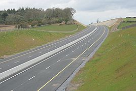
. Opened in sections between 1994 and 2010, the final section opened on 9 September 2010.
Prior to July 2008, the majority of the M9 – from Junction 2 onwards – was to be built as High Quality Dual Carriageway (HQDC). Due to the passing of a Statutory Instrument
in that month, a large section of the route was re-designated to motorway standard. The section included the motorway under construction between Kilcullen and Powerstown and the (then) newly-opened Carlow bypass. The remainder of the route has since been redesignated.
bypass with the Carlow
bypass began in February 2008. This section was completed and opened on 21 December 2009. It runs between Junctions 2 and 4 on the M9 corridor.
for Rosslare
and the R448
for Leighlinbridge
.
) comprising 12 km of motorway was opened on 22 March 2010, in conjunction with the Knocktopher to Waterford section. The remaining section, Leighlinbridge
to Danesfort
, opened on 9 September 2010, thus completing the entire motorway. The scheme was built by SiskRoadbridge(SRB) Ltd.
. The left exit from this roundabout accesses the N9 road which continues to Waterford.
(NRA) plans to construct Motorway Service Areas at approximately 60 kilometre intervals along each of Ireland's interurban routes. Under this plan, the M9 will have two such areas. The first will be located near the M7/M9 interchange between Junctions 3 and 2. The second will be located south of Carlow
near Bagenalstown, between Junctions 7 and 8 (see here, p. 25). The EIS for the M9 Kilcullen Motorway Service Area is now available at the NRA website (scroll down to the bottom here).
As of January 2010, no details regarding the construction of the other M9 service area have been announced.
Republic of Ireland
Ireland , described as the Republic of Ireland , is a sovereign state in Europe occupying approximately five-sixths of the island of the same name. Its capital is Dublin. Ireland, which had a population of 4.58 million in 2011, is a constitutional republic governed as a parliamentary democracy,...
linking the M7 at Kilcullen
Kilcullen
Kilcullen , formally Kilcullen Bridge, is a small town on the River Liffey in County Kildare, Ireland. Its population of 2,985 makes it the 12th largest settlement in County Kildare and the fastest growing in the county, having doubled in population from 1,483 in the census of 2002...
to Waterford
Waterford
Waterford is a city in the South-East Region of Ireland. It is the oldest city in the country and fifth largest by population. Waterford City Council is the local government authority for the city and its immediate hinterland...
. Opened in sections between 1994 and 2010, the final section opened on 9 September 2010.
Prior to July 2008, the majority of the M9 – from Junction 2 onwards – was to be built as High Quality Dual Carriageway (HQDC). Due to the passing of a Statutory Instrument
Statutory Instrument
A Statutory Instrument is the principal form in which delegated or secondary legislation is made in Great Britain.Statutory Instruments are governed by the Statutory Instruments Act 1946. They replaced Statutory Rules and Orders, made under the Rules Publication Act 1893, in 1948.Most delegated...
in that month, a large section of the route was re-designated to motorway standard. The section included the motorway under construction between Kilcullen and Powerstown and the (then) newly-opened Carlow bypass. The remainder of the route has since been redesignated.
M7 to Kilcullen
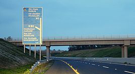
The M9 begins at Junction 11 (previously Junction 9) on the M7 motorway. This junction is a restricted access interchange, allowing traffic from the M9 to enter only the eastbound carriageway. There is no access to the M9 from the M7 eastbound, or to the M7 westbound from the M9. The route continues for 6 km before reaching the Kilcullen to Carlow section. The section runs between Junctions 1 and 2 on the M9 corridor. This section opened in 1994.Kilcullen to Carlow
Construction of 28 km of motorway linking the KilcullenKilcullen
Kilcullen , formally Kilcullen Bridge, is a small town on the River Liffey in County Kildare, Ireland. Its population of 2,985 makes it the 12th largest settlement in County Kildare and the fastest growing in the county, having doubled in population from 1,483 in the census of 2002...
bypass with the Carlow
Carlow
Carlow is the county town of County Carlow in Ireland. It is situated in the south-east of Ireland, 84 km from Dublin. County Carlow is the second smallest county in Ireland by area, however Carlow Town is the 14th largest urban area in Ireland by population according to the 2006 census. The...
bypass began in February 2008. This section was completed and opened on 21 December 2009. It runs between Junctions 2 and 4 on the M9 corridor.
Carlow Bypass
This 18.5 km (11 mi) section of motorway opened on the 29 May 2008 and runs between Junctions 4 and 6 on the M9 corridor. It provides a bypass of Carlow and allows access to the N80N80 road (Ireland)
The N80 road is a national secondary road in Ireland that runs southeastwards from its junction with the N52 and R443 in the town of Tullamore in County Offaly, to the N11 at Ballynahallin, just north of Enniscorthy in County Wexford, a distance of 116 km...
for Rosslare
Rosslare
The name Rosslare may refer to:*Rosslare Strand, a village in County Wexford, Ireland* Rosslare Harbour, a village in County Wexford, Ireland*The Rosslare Europort at Rosslare Harbour...
and the R448
R448 road
The R448 road is a regional road in Ireland. It is the designation given to sections of the former N9 national primary road when they are bypassed by sections of new highway.-References:* – Department of Transport...
for Leighlinbridge
Leighlinbridge
Leighlinbridge is a village on the River Barrow in County Carlow, Ireland. The N9 National primary route once passed through the village, which was by-passed in the 1980s. It now lies on the R705 regional road....
.
Carlow to Knocktopher
The first part of this section between Junctions 9 and 10 (Danesfort-KnocktopherKnocktopher
Knocktopher is a village in County Kilkenny, Ireland. It is situated on the M9 between the villages of Stoneyford to the north, and Ballyhale to the south....
) comprising 12 km of motorway was opened on 22 March 2010, in conjunction with the Knocktopher to Waterford section. The remaining section, Leighlinbridge
Leighlinbridge
Leighlinbridge is a village on the River Barrow in County Carlow, Ireland. The N9 National primary route once passed through the village, which was by-passed in the 1980s. It now lies on the R705 regional road....
to Danesfort
Danesfort
Danesfort is a small rural area in County Kilkenny, Ireland, located approximately 6 km from Kilkenny City on the N10 . The local area consists of one primary school, a local GAA pitch, a Roman Catholic Church and a soon-to-built care home for the elderly. The townland is divided almost...
, opened on 9 September 2010, thus completing the entire motorway. The scheme was built by SiskRoadbridge(SRB) Ltd.
Knocktopher to Waterford
The Knocktopher-Waterford section of the M9 route was opened on 22 March 2010. This section is 24 km long and runs between Junctions 10 and 12 on the M9 corridor. The scheme was built by BAM Ltd (formerly Ascon Ltd.). Junction 12 is not a standard motorway junction but is instead, a dangerous roundaboutRoundabout
A roundabout is the name for a road junction in which traffic moves in one direction around a central island. The word dates from the early 20th century. Roundabouts are common in many countries around the world...
. The left exit from this roundabout accesses the N9 road which continues to Waterford.
Junctions
| M9 Motorway | |||
| Northbound exit | Junction | Southbound exit | |
Road merges with (M7  ) )- Dublin, Kildare Kildare -External links:*******... , Naas Naas Naas is the county town of County Kildare in Ireland. With a population of just over twenty thousand, it is also the largest town in the county. Naas is a major commuter suburb, with many people residing there and working in Dublin... |
 |
Start of motorway | |
| Kilcullen Kilcullen Kilcullen , formally Kilcullen Bridge, is a small town on the River Liffey in County Kildare, Ireland. Its population of 2,985 makes it the 12th largest settlement in County Kildare and the fastest growing in the county, having doubled in population from 1,483 in the census of 2002... , Athy Athy The town developed from a 12th century Anglo-Norman settlement to an important British military outpost on the border of the Pale.The first town charter dates from the 16th century and the town hall was constructed in the early 18th century... (N78 N78 road (Ireland) The N78 road is a national secondary road in Ireland. The 50km long road links the N77 national secondary road north of Kilkenny, County Kilkenny to the M9 national primary route at Mullamast in County Kildare. En route it passes through the towns of Castlecomer in County Kilkenny, Ballylynan in... ) |
 |
Kilcullen Kilcullen Kilcullen , formally Kilcullen Bridge, is a small town on the River Liffey in County Kildare, Ireland. Its population of 2,985 makes it the 12th largest settlement in County Kildare and the fastest growing in the county, having doubled in population from 1,483 in the census of 2002... , Athy Athy The town developed from a 12th century Anglo-Norman settlement to an important British military outpost on the border of the Pale.The first town charter dates from the 16th century and the town hall was constructed in the early 18th century... (N78 N78 road (Ireland) The N78 road is a national secondary road in Ireland. The 50km long road links the N77 national secondary road north of Kilkenny, County Kilkenny to the M9 national primary route at Mullamast in County Kildare. En route it passes through the towns of Castlecomer in County Kilkenny, Ballylynan in... ) |
|
| Kilcullen Services (Proposed) | |
Kilcullen Services (Proposed) | |
| Parking | |
Parking | |
| Athy Athy The town developed from a 12th century Anglo-Norman settlement to an important British military outpost on the border of the Pale.The first town charter dates from the 16th century and the town hall was constructed in the early 18th century... , Baltinglass Baltinglass Baltinglass or Baltinglas is a town in south-west County Wicklow, Ireland. It is situated on the River Slaney near the border with County Carlow and County Kildare, on the N81 road. Its Irish name means "the way of Conglas", Conglas being a member of the mythological warrior collective, the Fianna... , Moone Moone Moone is a small village in the south of County Kildare, Ireland. It is on the former N9 road about south of Dublin. It has only a few hundred inhabitants, a church, a National School, one shop and a small community centre... (N78 N78 road (Ireland) The N78 road is a national secondary road in Ireland. The 50km long road links the N77 national secondary road north of Kilkenny, County Kilkenny to the M9 national primary route at Mullamast in County Kildare. En route it passes through the towns of Castlecomer in County Kilkenny, Ballylynan in... ) |
 |
Athy Athy The town developed from a 12th century Anglo-Norman settlement to an important British military outpost on the border of the Pale.The first town charter dates from the 16th century and the town hall was constructed in the early 18th century... , Baltinglass Baltinglass Baltinglass or Baltinglas is a town in south-west County Wicklow, Ireland. It is situated on the River Slaney near the border with County Carlow and County Kildare, on the N81 road. Its Irish name means "the way of Conglas", Conglas being a member of the mythological warrior collective, the Fianna... , Moone Moone Moone is a small village in the south of County Kildare, Ireland. It is on the former N9 road about south of Dublin. It has only a few hundred inhabitants, a church, a National School, one shop and a small community centre... (N78 N78 road (Ireland) The N78 road is a national secondary road in Ireland. The 50km long road links the N77 national secondary road north of Kilkenny, County Kilkenny to the M9 national primary route at Mullamast in County Kildare. En route it passes through the towns of Castlecomer in County Kilkenny, Ballylynan in... ) |
|
| Carlow Carlow Carlow is the county town of County Carlow in Ireland. It is situated in the south-east of Ireland, 84 km from Dublin. County Carlow is the second smallest county in Ireland by area, however Carlow Town is the 14th largest urban area in Ireland by population according to the 2006 census. The... (R448 R448 road The R448 road is a regional road in Ireland. It is the designation given to sections of the former N9 national primary road when they are bypassed by sections of new highway.-References:* – Department of Transport... ) |
 |
Carlow Carlow Carlow is the county town of County Carlow in Ireland. It is situated in the south-east of Ireland, 84 km from Dublin. County Carlow is the second smallest county in Ireland by area, however Carlow Town is the 14th largest urban area in Ireland by population according to the 2006 census. The... (R448 R448 road The R448 road is a regional road in Ireland. It is the designation given to sections of the former N9 national primary road when they are bypassed by sections of new highway.-References:* – Department of Transport... ) |
|
| Carlow Carlow Carlow is the county town of County Carlow in Ireland. It is situated in the south-east of Ireland, 84 km from Dublin. County Carlow is the second smallest county in Ireland by area, however Carlow Town is the 14th largest urban area in Ireland by population according to the 2006 census. The... , Rosslare Rosslare The name Rosslare may refer to:*Rosslare Strand, a village in County Wexford, Ireland* Rosslare Harbour, a village in County Wexford, Ireland*The Rosslare Europort at Rosslare Harbour... (N80 N80 road (Ireland) The N80 road is a national secondary road in Ireland that runs southeastwards from its junction with the N52 and R443 in the town of Tullamore in County Offaly, to the N11 at Ballynahallin, just north of Enniscorthy in County Wexford, a distance of 116 km... ) |
 |
Carlow Carlow Carlow is the county town of County Carlow in Ireland. It is situated in the south-east of Ireland, 84 km from Dublin. County Carlow is the second smallest county in Ireland by area, however Carlow Town is the 14th largest urban area in Ireland by population according to the 2006 census. The... , Rosslare Rosslare The name Rosslare may refer to:*Rosslare Strand, a village in County Wexford, Ireland* Rosslare Harbour, a village in County Wexford, Ireland*The Rosslare Europort at Rosslare Harbour... (N80 N80 road (Ireland) The N80 road is a national secondary road in Ireland that runs southeastwards from its junction with the N52 and R443 in the town of Tullamore in County Offaly, to the N11 at Ballynahallin, just north of Enniscorthy in County Wexford, a distance of 116 km... ) |
|
| Leighlinbridge Leighlinbridge Leighlinbridge is a village on the River Barrow in County Carlow, Ireland. The N9 National primary route once passed through the village, which was by-passed in the 1980s. It now lies on the R705 regional road.... (R448 R448 road The R448 road is a regional road in Ireland. It is the designation given to sections of the former N9 national primary road when they are bypassed by sections of new highway.-References:* – Department of Transport... ) |
 |
Leighlinbridge Leighlinbridge Leighlinbridge is a village on the River Barrow in County Carlow, Ireland. The N9 National primary route once passed through the village, which was by-passed in the 1980s. It now lies on the R705 regional road.... (R448 R448 road The R448 road is a regional road in Ireland. It is the designation given to sections of the former N9 national primary road when they are bypassed by sections of new highway.-References:* – Department of Transport... ) |
|
| Paulstown Paulstown Paulstown is a small village in County Kilkenny in Ireland.Paulstown is located at the junction of the N9 and N10 National primary roads. It is 21 km south of Carlow and 19 km east of Kilkenny.... , Gowran Gowran Gowran is a village and former town in County Kilkenny, Ireland. Gowran Park race course is located nearby. Gowran is located on the N9 national primary road where it is crossed by the R702 regional road.-History:... (R448 R448 road The R448 road is a regional road in Ireland. It is the designation given to sections of the former N9 national primary road when they are bypassed by sections of new highway.-References:* – Department of Transport... ) |
 |
Paulstown Paulstown Paulstown is a small village in County Kilkenny in Ireland.Paulstown is located at the junction of the N9 and N10 National primary roads. It is 21 km south of Carlow and 19 km east of Kilkenny.... , Gowran Gowran Gowran is a village and former town in County Kilkenny, Ireland. Gowran Park race course is located nearby. Gowran is located on the N9 national primary road where it is crossed by the R702 regional road.-History:... (R448 R448 road The R448 road is a regional road in Ireland. It is the designation given to sections of the former N9 national primary road when they are bypassed by sections of new highway.-References:* – Department of Transport... ) |
|
| Kilkenny Kilkenny Kilkenny is a city and is the county town of the eponymous County Kilkenny in Ireland. It is situated on both banks of the River Nore in the province of Leinster, in the south-east of Ireland... |
 |
Kilkenny Kilkenny Kilkenny is a city and is the county town of the eponymous County Kilkenny in Ireland. It is situated on both banks of the River Nore in the province of Leinster, in the south-east of Ireland... |
|
| Kilkenny Kilkenny Kilkenny is a city and is the county town of the eponymous County Kilkenny in Ireland. It is situated on both banks of the River Nore in the province of Leinster, in the south-east of Ireland... (N10) |
 |
Kilkenny Kilkenny Kilkenny is a city and is the county town of the eponymous County Kilkenny in Ireland. It is situated on both banks of the River Nore in the province of Leinster, in the south-east of Ireland... (N10) |
|
| Parking | |
Parking | |
| Knocktopher Knocktopher Knocktopher is a village in County Kilkenny, Ireland. It is situated on the M9 between the villages of Stoneyford to the north, and Ballyhale to the south.... (R699) |
 |
Knocktopher Knocktopher Knocktopher is a village in County Kilkenny, Ireland. It is situated on the M9 between the villages of Stoneyford to the north, and Ballyhale to the south.... (R699) |
|
| Parking | |
No exit | |
| Mullinavat Mullinavat Mullinavat is a town in south County Kilkenny, Ireland. Its main industries are tourism and agriculture. It has a renowned sporting history, particularly in hurling.-Location and access:... (R448 R448 road The R448 road is a regional road in Ireland. It is the designation given to sections of the former N9 national primary road when they are bypassed by sections of new highway.-References:* – Department of Transport... ) |
|
Mullinavat Mullinavat Mullinavat is a town in south County Kilkenny, Ireland. Its main industries are tourism and agriculture. It has a renowned sporting history, particularly in hurling.-Location and access:... (R448 R448 road The R448 road is a regional road in Ireland. It is the designation given to sections of the former N9 national primary road when they are bypassed by sections of new highway.-References:* – Department of Transport... ) |
|
| No exit | |
Parking | |
| Start of motorway |  |
Limerick Limerick Limerick is the third largest city in the Republic of Ireland, and the principal city of County Limerick and Ireland's Mid-West Region. It is the fifth most populous city in all of Ireland. When taking the extra-municipal suburbs into account, Limerick is the third largest conurbation in the... , Clonmel Clonmel Clonmel is the county town of South Tipperary in Ireland. It is the largest town in the county. While the borough had a population of 15,482 in 2006, another 17,008 people were in the rural hinterland. The town is noted in Irish history for its resistance to the Cromwellian army which sacked both... (N24) (Roundabout - second exit) |
|
Proposed Service Areas
The National Roads AuthorityNational Roads Authority
The National Roads Authority is a state body in the Republic of Ireland, responsible for the national road network. The NRA was established as part of the Roads Act 1993 and commenced operations on 23 December 1993 in accordance with S.I. 407 of 1993.County councils remain responsible for local...
(NRA) plans to construct Motorway Service Areas at approximately 60 kilometre intervals along each of Ireland's interurban routes. Under this plan, the M9 will have two such areas. The first will be located near the M7/M9 interchange between Junctions 3 and 2. The second will be located south of Carlow
Carlow
Carlow is the county town of County Carlow in Ireland. It is situated in the south-east of Ireland, 84 km from Dublin. County Carlow is the second smallest county in Ireland by area, however Carlow Town is the 14th largest urban area in Ireland by population according to the 2006 census. The...
near Bagenalstown, between Junctions 7 and 8 (see here, p. 25). The EIS for the M9 Kilcullen Motorway Service Area is now available at the NRA website (scroll down to the bottom here).
As of January 2010, no details regarding the construction of the other M9 service area have been announced.