

Regional road
Encyclopedia
A regional road in Ireland
is a class of road not forming a major route (such as a national primary road
or national secondary road
), but nevertheless forming a link in the national route network
. There are over 11,600 kilometres of regional roads. Regional roads are numbered with three digit route numbers, prefixed by "R" (e.g. R105).
. The Local Government (Roads and Motorways) Act authorised the designation of roads as National roads: in 1977, twenty-five National Primary roads (N1-N25) and thirty-three National Secondary roads (N51-N83) were initially designated under Statutory Instrument S.I. No. 164/1977.
Many of the remaining classified roads became Regional roads (formally authorised under the Roads Act 1993, having been present on road signs on a non-statutory basis for some years previously) and their routes were designated under a Statutory Instrument
('SI') in 1994. The latest SI designating the routes of Regional roads was published in 2006: the Roads Act 1993 (Classification of Regional Roads) Order 2006.
Other roads formerly classified as Trunk or Link roads eventually became Local roads
.
Older signs showing the former Trunk and Link road designations are still to be seen in some locations. The L (for Link Road) prefix on these signs is not connected to the network of Local roads currently in place.
. The vast majority of the regional road network is made up of single carriageway
roads although some roads are dual carriageway
(see: High capacity regional roads). Until the late 1990s, such roads were frequently in very poor condition, although increased road maintenance funding to local councils has resulted in more frequent resurfacing of regional roads, as well as relaying and realignment on some routes.
Regional roads are generally subject to a speed limit
of 80 km/h (imperial equivalent 50 mph), rather than the 100 km/h (imperial equivalent 62.5 mph) for national roads. Prior to 20 January 2005, when Ireland adopted metric speed limits, national and regional roads had identical speed limits of 60 mph. Regional roads, however, pass through towns, villages and built-up areas frequently, so even lower local speed restrictions are often in place. However, certain regional roads, often sections of former national roads which have been bypassed by motorways
or other road improvements, have speed limits of 100 km/h. The R132
(former N1) is an example of a Regional road with a 100 km/h speed limit.
 , directional signposting
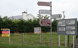
on some regional roads in Ireland remains poor, with even modern signage usually relying on fingerpost signposts located directly at junctions. However, work on improving signposting on regional roads has been continuing since 2003; routes which previously had the most deficient signposting were selected for upgrading first. In 2007, a total of "€7 million to continue progress on the regional roads signposting programme, which commenced in 2003" was granted to local authorities.
(Belgard Road) and R445
(Old Naas Road), R132 Swords Inner By-pass and R136
Dublin Outer Ring Road which have sections of dual carriageway.
In some cases, important high capacity urban routes are built or designated as regional roads, such as the mostly dual carriageway R710
Waterford Outer Ring Road, or the R774
Greystones
to the N11 link, which is dual carriageway for its full length.
In many other cases, upgraded regional roads (for example, wide two lane) were previously part of a national primary road, prior to the construction of a motorway or other bypass. In most cases, when a national primary road is changed by the creation of a bypass (motorway or other), the road previously forming part of the route is reclassified as a regional road rather than as a local road.
Republic of Ireland
Ireland , described as the Republic of Ireland , is a sovereign state in Europe occupying approximately five-sixths of the island of the same name. Its capital is Dublin. Ireland, which had a population of 4.58 million in 2011, is a constitutional republic governed as a parliamentary democracy,...
is a class of road not forming a major route (such as a national primary road
National primary road
A national primary road is a road classification in the Republic of Ireland. National primary roads form the major routes between the major urban centres. There are over 2,700km of national primary roads. This category of road has the prefix "N" followed by one or two digits...
or national secondary road
National secondary road
A national secondary road is a category of road in Ireland. These roads form an important part of the national route network, but are secondary to the main arterial routes which are classified as national primary roads. National secondary roads are designated with route numbers higher than those...
), but nevertheless forming a link in the national route network
Roads in Ireland
The island of Ireland, comprising Northern Ireland and the Republic of Ireland, has an extensive network of tens of thousands of kilometres of public roads, usually surfaced. These roads have been developed and modernised over centuries, from trackways suitable only for walkers and horses, to...
. There are over 11,600 kilometres of regional roads. Regional roads are numbered with three digit route numbers, prefixed by "R" (e.g. R105).
History
Until 1977, roads in Ireland were designated with one of two prefixes: "T" for Trunk Roads and "L" for Link RoadsTrunk Roads in Ireland
Ireland has an extensive network of public roads which connect all parts of the country with each other. Roads in Ireland are currently classified as motorways, National Primary routes, National secondary routes, Regional roads and Local roads. The introduction of this classification system began...
. The Local Government (Roads and Motorways) Act authorised the designation of roads as National roads: in 1977, twenty-five National Primary roads (N1-N25) and thirty-three National Secondary roads (N51-N83) were initially designated under Statutory Instrument S.I. No. 164/1977.
Many of the remaining classified roads became Regional roads (formally authorised under the Roads Act 1993, having been present on road signs on a non-statutory basis for some years previously) and their routes were designated under a Statutory Instrument
Statutory Instrument
A Statutory Instrument is the principal form in which delegated or secondary legislation is made in Great Britain.Statutory Instruments are governed by the Statutory Instruments Act 1946. They replaced Statutory Rules and Orders, made under the Rules Publication Act 1893, in 1948.Most delegated...
('SI') in 1994. The latest SI designating the routes of Regional roads was published in 2006: the Roads Act 1993 (Classification of Regional Roads) Order 2006.
Other roads formerly classified as Trunk or Link roads eventually became Local roads
Local Roads in Ireland
A Local Road in Ireland is a class of public road not classified as a National road or as a Regional road but nevertheless forming a link in the national network of roads...
.
Older signs showing the former Trunk and Link road designations are still to be seen in some locations. The L (for Link Road) prefix on these signs is not connected to the network of Local roads currently in place.
Features
Unlike national roads, regional roads are maintained by local county or city councils rather than the National Roads AuthorityNational Roads Authority
The National Roads Authority is a state body in the Republic of Ireland, responsible for the national road network. The NRA was established as part of the Roads Act 1993 and commenced operations on 23 December 1993 in accordance with S.I. 407 of 1993.County councils remain responsible for local...
. The vast majority of the regional road network is made up of single carriageway
Single carriageway
A single carriageway is a road with 1, 2 or more lanes arranged within a single carriageway with no central reservation to separate opposing flows of traffic. Two-lane road or two-lane highway are single carriageway with one lane for each direction...
roads although some roads are dual carriageway
Dual carriageway
A dual carriageway is a class of highway with two carriageways for traffic travelling in opposite directions separated by a central reservation...
(see: High capacity regional roads). Until the late 1990s, such roads were frequently in very poor condition, although increased road maintenance funding to local councils has resulted in more frequent resurfacing of regional roads, as well as relaying and realignment on some routes.
Regional roads are generally subject to a speed limit
Road speed limits in the Republic of Ireland
Road speed limits in the Republic of Ireland apply on all public roads in the country. These are signposted and legislated for in kilometres per hour. Speed limits are demarcated by regulatory road signs . These consist of white circular signs with a red outline. Speed limits are marked in black...
of 80 km/h (imperial equivalent 50 mph), rather than the 100 km/h (imperial equivalent 62.5 mph) for national roads. Prior to 20 January 2005, when Ireland adopted metric speed limits, national and regional roads had identical speed limits of 60 mph. Regional roads, however, pass through towns, villages and built-up areas frequently, so even lower local speed restrictions are often in place. However, certain regional roads, often sections of former national roads which have been bypassed by motorways
Motorways in the Republic of Ireland
In Ireland, the highest category of road is a Motorway , indicated by the prefix M followed by one or two digits...
or other road improvements, have speed limits of 100 km/h. The R132
R132 road
The R132 road is one of Ireland's newest regional roads, having been classified following the opening M1 motorway which by-passes most of the old N1 route.By-passed sections of the old N1 were reclassified R132...
(former N1) is an example of a Regional road with a 100 km/h speed limit.
Road signs in the Republic of Ireland
Road signs in Ireland mostly differ from the traffic signs used elsewhere in Europe. Directional signage is similar to that of the United Kingdom, but is bilingual. Distances are in kilometres. Apart from directional signage, the basic prohibitory signs such as "no left turn" and "no right turn"...
on some regional roads in Ireland remains poor, with even modern signage usually relying on fingerpost signposts located directly at junctions. However, work on improving signposting on regional roads has been continuing since 2003; routes which previously had the most deficient signposting were selected for upgrading first. In 2007, a total of "€7 million to continue progress on the regional roads signposting programme, which commenced in 2003" was granted to local authorities.
High capacity regional roads
There are some higher capacity (i.e. not just single carriageway) sections of regional road, most notably the R113R113 road
The R113 road is a regional road in Ireland. Located in the east of Ireland at Dublin, it forms a semi-orbital route around the south of the city. As of 2007, clockwise, it starts at the N31 at Temple Hill in Blackrock and ends at a junction with the N4 at Palmerstown.The road is one of the...
(Belgard Road) and R445
R445 road
The R445 road is a regional road in Ireland. The route is a non-motorway alternative route to the N7/M7 motorway between Dublin and Limerick. Indeed, much of the route comprises roads that were formerly part of the N7 between the cities, prior to motorway and other bypasses...
(Old Naas Road), R132 Swords Inner By-pass and R136
R136 road
The R136 road is a regional road in Ireland, located in the southwest of Dublin. Named the Outer Ring Road, the route , bypasses west of Clondalkin connecting the N4 to the Tallaght Bypass , crossing the N7...
Dublin Outer Ring Road which have sections of dual carriageway.
In some cases, important high capacity urban routes are built or designated as regional roads, such as the mostly dual carriageway R710
R710 road
The R710 road is a regional road in Ireland. Located in the south of Ireland at Waterford, it forms the Outer Ring Road around the south of the city...
Waterford Outer Ring Road, or the R774
R774 road
The R774 road is a regional road in County Wicklow, Ireland, which has been named the Farenkelly Road. It is a dual-carriageway that connects the town of Greystones with the N11 national primary road...
Greystones
Greystones
Greystones is a coastal town and small seaside resort in County Wicklow, Ireland. It is located on Ireland’s east coast, south of Bray and south of Dublin , with a population in the region of 15,000....
to the N11 link, which is dual carriageway for its full length.
In many other cases, upgraded regional roads (for example, wide two lane) were previously part of a national primary road, prior to the construction of a motorway or other bypass. In most cases, when a national primary road is changed by the creation of a bypass (motorway or other), the road previously forming part of the route is reclassified as a regional road rather than as a local road.
Route descriptions
Routes of all regional roads in Ireland are defined by Statutory Instrument No. 188 of 2006, the Roads Act 1993 (Classification of Regional Roads) Order 2006; which specifies townlands, villages, towns, other settlements through which the route passes, as well as road names applied to route sections where applicable. The direction of any given route (that is, which end is the start and which is the termination) is determined by the route description in the Statutory Instrument, thus any route can be listed in the form "Start, Intermediate Destinations, Final Destination" as below:Dublin, North Leinster, Cavan and Monaghan
- R101North Circular Road, DublinThe North Circular Road - designated as R101 regional road - is an important thoroughfare on the northside of Dublin, in Ireland. The regional road was long considered the northern boundary of the city and still separates the city centre from the inner suburbs. It is also known for its Pevsner...
– North Circular Road, Dublin - R102R102 roadThe R102 road is a regional road in Dublin, Ireland, which describes a broad arc across the north of the city, connecting the N3 — at its M50 motorway intersection — to the R107 on the other side of the city....
– BlanchardstownBlanchardstownBlanchardstown is a large suburb of Dublin in the district of Fingal, Ireland. It is within the historical barony of Castleknock. It is located 10 km north-west of the city centre. The suburb is in the Dublin 15 postal area, the Dublin West electoral constituency, and Fingal County...
– MalahideMalahideMalahide is a coastal suburban town, near Dublin city, located in the administrative county of Fingal, within the traditional County Dublin, Ireland. It has a village-like centre and extensive residential areas to the south, west and northwest.-Name:...
Road, Dublin - R103R103 road (Ireland)The R103 road is a regional road in north Dublin, Ireland.The official description of the R103 from the Roads Act 1993 Order 2006 reads:-See also:*Roads in Ireland*National primary road*National secondary road...
– KillesterKillesterKillester is a small, largely residential suburb of Dublin and lies on the Northside of the city.-Location and access:Killester is located between Clontarf, Donnycarney, Raheny and Artane, and it falls within the postal districts of Dublin 3 or 5. St. Anne's Park lies just beyond Killester on the...
, Dublin - R104 – FinglasFinglas-See also:* List of towns and villages in Ireland* List of abbeys and priories in Ireland...
– KilbarrackKilbarrackKilbarrack is a residential suburb of Dublin, Ireland, running inwards from the coast, about from the city's centre. Modern-day Kilbarrack is within the jurisdiction of Dublin City Council, with part of its old lands now in Donaghmede, and part in Bayside under Fingal County Council...
, Dublin - R105R105 roadThe R105 road is a regional road in north Dublin, Ireland. It travels from the city centre to Howth, and the road loops at both ends.The official description of the R105 from the Roads Act 1993 Order 2006 reads:...
– Dublin – HowthHowthHowth is an area in Fingal County near Dublin city in Ireland. Originally just a small fishing village, Howth with its surrounding rural district is now a busy suburb of Dublin, with a mix of dense residential development and wild hillside, all on the peninsula of Howth Head. The only... - R106R106 roadThe R106 road is a regional road in north Dublin, Ireland.The official description of the R106 from the Roads Act 1993 Order 2006 reads:-See also:*Roads in Ireland*National primary road*National secondary road...
– SuttonSutton, DublinSutton is a residential suburb of Dublin's Northside, Ireland, at the base of Howth Head, the peninsula which forms the northern edge of Dublin Bay.-Location and geography:...
– MalahideMalahideMalahide is a coastal suburban town, near Dublin city, located in the administrative county of Fingal, within the traditional County Dublin, Ireland. It has a village-like centre and extensive residential areas to the south, west and northwest.-Name:...
– SwordsSwords, DublinSwords is the county town of Fingal in Ireland. It is about 13 km north of Dublin city centre and is part of its commuter belt.- History :... - R107R107 roadThe R107 road is a regional road in north Dublin, Ireland which travels northwestwards from Fairview to Malahide. The official description of the R101 from the Roads Act 1993 Order 2006 reads:The road is long....
– Dublin – MalahideMalahideMalahide is a coastal suburban town, near Dublin city, located in the administrative county of Fingal, within the traditional County Dublin, Ireland. It has a village-like centre and extensive residential areas to the south, west and northwest.-Name:... - R108R108 roadThe R108 road is a regional road in Ireland, linking Drogheda in County Louth to the N2 in Phibsborough, Dublin.The official description of the R108 from the Roads Act 1993 Order 2006 reads:The road is long....
– DroghedaDroghedaDrogheda is an industrial and port town in County Louth on the east coast of Ireland, 56 km north of Dublin. It is the last bridging point on the River Boyne before it enters the Irish Sea....
– N2 in PhibsboroPhibsboroPhibsborough , often formerly shortened to Phibsboro and later Phibsboro , is a district of Dublin in Ireland.-Location:Phibsboro' is located in the Dublin 7 postal district on the Northside of the city. The area is very close to the city centre, about two kilometres from the River Liffey which...
ugh, Dublin - R109R109 roadThe R109 road is a regional road in west Dublin, Ireland.The official description of the R109 from the Roads Act 1993 Order 2006 reads:-See also:*Roads in Ireland*National primary road*National secondary road...
– Lucan – Wolf Tone Quay, Dublin - R110R110 roadThe R110 road is a regional road in Ireland which goes from St Stephen's Green to Red Cow, Dublin. Its route is completely within the Dublin urban area....
– St Stephen's Green – Red CowRed Cow roundaboutThe Red Cow interchange is a major road junction in west Dublin, Ireland on the M50, meeting the N7 Naas Road at a free-flow grade separated junction which incorporates a light railway line...
, Dublin - R111R111 roadThe R111 road is a regional road in south Dublin, Ireland. The official description of the R111 from the Roads Act 1993 Order 2006 reads:- Dublin Outer Orbital Route :...
– Dublin Outer Orbital Route (south) - Conyngham Road – Beach Road, SandymountSandymountSandymount is a coastal seaside suburb in Dublin 4 on the Southside of Dublin in Ireland. It is in the Dublin South East Dáil constituency and the East Pembroke Ward. It was once part of Pembroke Township, which took its name from the fact that this area was part of the estate of the Earl of...
, Dublin - R112R112 roadThe R112 road is a regional road in south Dublin, Ireland. It begins at the junction with the N4 road at Chapelizod and arcs southeastwards, then eastwards across the middle of south Dublin, ending at the Mount Merrion junction of the N11. The road is single carriageway, with cycle lanes on some...
– ChapelizodChapelizodChapelizod is a picturesque Irish village preserved within the city of Dublin, Ireland. It lies in the verdant wooded valley of the River Liffey, on the way to the slopes of the Strawberry Beds, below the Phoenix Park. The village is associated with Iseult of Ireland and the location of Iseault's...
– TempleogueTempleogueTempleogue is a suburb of southwest Dublin, Ireland. The original Irish name Teach Mealóg refers to a chapel named after Saint Mel that was built there in about 1273....
– ChurchtownChurchtown, DublinChurchtown is a largely residential suburb on the southside of Dublin, Ireland, between Dundrum and Rathfarnham. It is in the postal districts Dublin 14 and Dublin 16.- Ely's Arch :...
– Mount MerrionMount MerrionMount Merrion is an area of Dublin, Ireland. It is roughly 7 kilometres south of the city centre. It is situated on and around a hill of the same name.-Location and access:... - R113R113 roadThe R113 road is a regional road in Ireland. Located in the east of Ireland at Dublin, it forms a semi-orbital route around the south of the city. As of 2007, clockwise, it starts at the N31 at Temple Hill in Blackrock and ends at a junction with the N4 at Palmerstown.The road is one of the...
– Fonthill Road from N4 near Lucan – N7 near ClondalkinClondalkin-Today:Modern Clondalkin is a busy satellite town of Dublin, with a population of 43,929 in 2006. Retail facilities include Tesco Ireland- and Dunnes Stores-led shopping centres, and Aldi and Lidl stores on the Fonthill Road and New Nangor Road respectively, and the village centre is a base for...
– Belgard Road (dual–carriageway) from N7 – N81 at TallaghtTallaghtTallaght is the largest town, and county town, of South Dublin County, Ireland. The village area, dating from at least the 17th century, held one of the earliest settlements known in the southern part of the island, and one of medieval Ireland's more important monastic centres.Up to the 1960s... - R114R114 roadThe R114 road is a regional road in south Dublin, Ireland. The road runs from the city centre to Brittas in southwest County Dublin. The official description of the R114 from the Roads Act 1993 Order 2006 reads:...
– RathfarnhamRathfarnhamRathfarnham or Rathfarnam is a Southside suburb of Dublin, Ireland. It is south of Terenure, east of Templeogue, and is in the postal districts of Dublin 14 and 16. It is within the administrative areas of both Dun Laoghaire-Rathdown and South Dublin County Councils.The area of Rathfarnham...
– Brittas, DublinBrittas, DublinBrittas is a village in South County Dublin just north of the border with County Wicklow on the N81 road. It is in the foothills of the Dublin Mountains and lies just 15 minutes drive from the remote outskirts of Dublin City.... - R115R115 roadThe R115 road is a regional road in counties Dublin and Wicklow in Ireland. It follows the Military Road for its entire length. The R115 is long; the full length of the Military Road is...
– The Military Road – RathfarnhamRathfarnhamRathfarnham or Rathfarnam is a Southside suburb of Dublin, Ireland. It is south of Terenure, east of Templeogue, and is in the postal districts of Dublin 14 and 16. It is within the administrative areas of both Dun Laoghaire-Rathdown and South Dublin County Councils.The area of Rathfarnham...
, Dublin – LaraghLaragh, County WicklowLaragh is a small picturesque village in County Wicklow, Ireland. It lies at the junction of three roads through the Wicklow Mountains and is primarily known for its proximity to the monastic settlement of Glendalough...
near GlendaloughGlendaloughGlendalough or Glendaloch is a glacial valley in County Wicklow, Ireland. It is renowned for its Early Medieval monastic settlement founded in the 6th century by St Kevin, a hermit priest, and partly destroyed in 1398 by English troops....
, County WicklowCounty WicklowCounty Wicklow is a county in Ireland. It is part of the Mid-East Region and is also located in the province of Leinster. It is named after the town of Wicklow, which derives from the Old Norse name Víkingalág or Wykynlo. Wicklow County Council is the local authority for the county... - R116R116 roadThe R116 road is a regional road in Ireland which runs east-west from the N11 at Loughlinstown to the R115 in Ballyboden. It runs through the South of County Dublin for its entire length...
– LoughlinstownLoughlinstownLoughlinstown is a south Dublin suburb. Located in the County of Dun Laoghaire-Rathdown it lies on the N11 National Primary Route.Loughlinstown is the location of St. Columcille's Hospital, which serves both south Dublin and north Wicklow...
– BallybodenBallybodenBallyboden is a locality within the suburb of Rathfarnham in South Dublin, at the foot of the Dublin mountains between Whitechurch, Ballyroan and Knocklyon....
, all in South County DublinCounty DublinCounty Dublin is a county in Ireland. It is part of the Dublin Region and is also located in the province of Leinster. It is named after the city of Dublin which is the capital of Ireland. County Dublin was one of the first of the parts of Ireland to be shired by King John of England following the... - R117R117 roadThe R117 road is a regional road in Ireland. The route starts Harcourt Road at the end of the South Circular Road on the southside of Dublin city centre...
– Dublin city centre via EnniskerryEnniskerryEnniskerry is a village in County Wicklow, Ireland. It had a population of 2,672 at the 2006 census.- Location :...
– BrayBrayBray is a town in north County Wicklow, Ireland. It is a busy urban centre and seaside resort, with a population of 31,901 making it the fourth largest in Ireland as of the 2006 census...
, County WicklowCounty WicklowCounty Wicklow is a county in Ireland. It is part of the Mid-East Region and is also located in the province of Leinster. It is named after the town of Wicklow, which derives from the Old Norse name Víkingalág or Wykynlo. Wicklow County Council is the local authority for the county... - R118R118 roadThe R118 road is a regional road in south Dublin and Dun Laoghaire - Rathdown, Ireland.The official description of the R118 from the Roads Act 1993 Order 2006 reads:-See also:*Roads in Ireland*National primary road...
– Blackrock, Dublin – Dún LaoghaireDún LaoghaireDún Laoghaire or Dún Laoire , sometimes anglicised as "Dunleary" , is a suburban seaside town in County Dublin, Ireland, about twelve kilometres south of Dublin city centre. It is the county town of Dun Laoghaire-Rathdown County and a major port of entry from Great Britain...
– Lahaunstown, County DublinCounty DublinCounty Dublin is a county in Ireland. It is part of the Dublin Region and is also located in the province of Leinster. It is named after the city of Dublin which is the capital of Ireland. County Dublin was one of the first of the parts of Ireland to be shired by King John of England following the... - R119R119 roadThe R119 road is a regional road in Dun Laoghaire - Rathdown, Ireland.The official description of the R119 from the Roads Act 1993 Order 2006 reads:-See also:*Roads in Ireland*National primary road...
– Blackrock, Dublin – Dún LaoghaireDún LaoghaireDún Laoghaire or Dún Laoire , sometimes anglicised as "Dunleary" , is a suburban seaside town in County Dublin, Ireland, about twelve kilometres south of Dublin city centre. It is the county town of Dun Laoghaire-Rathdown County and a major port of entry from Great Britain...
, County Dublin – BrayBrayBray is a town in north County Wicklow, Ireland. It is a busy urban centre and seaside resort, with a population of 31,901 making it the fourth largest in Ireland as of the 2006 census...
, County WicklowCounty WicklowCounty Wicklow is a county in Ireland. It is part of the Mid-East Region and is also located in the province of Leinster. It is named after the town of Wicklow, which derives from the Old Norse name Víkingalág or Wykynlo. Wicklow County Council is the local authority for the county... - R120R120 roadThe R120 road is a regional road in south County Dublin, Ireland.The official description of the R120 from the Roads Act 1993 Order 2006 reads:-See also:*Roads in Ireland*National primary road...
– Lucan – RathcooleRathcoole, DublinRathcoole is a suburban village, south west of Tallaght, Ireland, in South Dublin County. It lies just off the N7 national primary road. It borders the nearby village of Saggart.- Geography :...
– Corbally, County DublinCounty DublinCounty Dublin is a county in Ireland. It is part of the Dublin Region and is also located in the province of Leinster. It is named after the city of Dublin which is the capital of Ireland. County Dublin was one of the first of the parts of Ireland to be shired by King John of England following the... - R121R121 roadThe R121 road is a regional road in south County Dublin and Fingal, Ireland.The official description of the R121 from the Roads Act 1993 Order 2006 reads:-See also:*Roads in Ireland*National primary road...
– Lucan – BlanchardstownBlanchardstownBlanchardstown is a large suburb of Dublin in the district of Fingal, Ireland. It is within the historical barony of Castleknock. It is located 10 km north-west of the city centre. The suburb is in the Dublin 15 postal area, the Dublin West electoral constituency, and Fingal County...
– Skephubble, County DublinCounty DublinCounty Dublin is a county in Ireland. It is part of the Dublin Region and is also located in the province of Leinster. It is named after the city of Dublin which is the capital of Ireland. County Dublin was one of the first of the parts of Ireland to be shired by King John of England following the... - R122R122 roadThe R122 road is a regional road in Fingal, Ireland.The official description of the R122 from the Roads Act 1993 Order 2006 reads:-See also:*Roads in Ireland*National primary road*National secondary road...
– FinglasFinglas-See also:* List of towns and villages in Ireland* List of abbeys and priories in Ireland...
– BalbrigganBalbrigganBalbriggan is a town in the northern part of the administrative county of Fingal, within County Dublin, Ireland. The 2006 census population was 15,559 for Balbriggan and its environs.- Name :...
, County DublinCounty DublinCounty Dublin is a county in Ireland. It is part of the Dublin Region and is also located in the province of Leinster. It is named after the city of Dublin which is the capital of Ireland. County Dublin was one of the first of the parts of Ireland to be shired by King John of England following the... - R123R123 roadThe R123 road is a regional road in Fingal, Ireland.The official description of the R123 from the Roads Act 1993 Order 2006 reads:-See also:*Roads in Ireland*National primary road*National secondary road...
– Maynetown – BalgriffinBalgriffinBalgriffin is a former rural, now largely residential, part of County Dublin, Ireland.-Location:Balgriffin is situated approximately from Dublin city centre...
, County DublinCounty DublinCounty Dublin is a county in Ireland. It is part of the Dublin Region and is also located in the province of Leinster. It is named after the city of Dublin which is the capital of Ireland. County Dublin was one of the first of the parts of Ireland to be shired by King John of England following the... - R124R124 roadThe R124 road is a regional road in Fingal, Ireland.The official description of the R124 from the Roads Act 1993 Order 2006 reads:-See also:*Roads in Ireland*National primary road*National secondary road...
– SnugboroughSnugboroughSnugborough is a townland in the Parish of Tomregan, Barony of Tullyhaw, County Cavan, Ireland. The older Irish name of the townland was ‘Kealloge’ which was an anglicisation of the Gaelic placename ‘Coill Og’, which means ‘"The New or Little Wood" and it is depicted with this name on the 1609...
– MalahideMalahideMalahide is a coastal suburban town, near Dublin city, located in the administrative county of Fingal, within the traditional County Dublin, Ireland. It has a village-like centre and extensive residential areas to the south, west and northwest.-Name:...
, County DublinCounty DublinCounty Dublin is a county in Ireland. It is part of the Dublin Region and is also located in the province of Leinster. It is named after the city of Dublin which is the capital of Ireland. County Dublin was one of the first of the parts of Ireland to be shired by King John of England following the... - R125R125 roadThe R125 road is a regional road in Ireland, linking Kilcock on the County Meath / County Kildare border to Swords in County Dublin via the towns of Dunshaughlin and Ratoath....
– Swords, DublinSwords, DublinSwords is the county town of Fingal in Ireland. It is about 13 km north of Dublin city centre and is part of its commuter belt.- History :...
– DunshaughlinDunshaughlin-History:It is named after Saint Seachnall, who established a church there in the 5th century.Máel Seachlainn was ancestor to the principal family of Brega, Ó Maoilsheachlainn, is descended...
County MeathCounty MeathCounty Meath is a county in Ireland. It is part of the Mid-East Region and is also located in the province of Leinster. It is named after the ancient Kingdom of Mide . Meath County Council is the local authority for the county...
– KilcockKilcockKilcock or Killcock is a town and townland in the north of County Kildare, Ireland, on the border with County Meath. Kilcock is a dormitory town for many of those who work in Dublin...
, County KildareCounty KildareCounty Kildare is a county in Ireland. It is part of the Mid-East Region and is also located in the province of Leinster. It is named after the town of Kildare. Kildare County Council is the local authority for the county... - R126R126 roadThe R126 road is a regional road in Fingal, Ireland.The official description of the R126 from the Roads Act 1993 Order 2006 reads:-See also:*Roads in Ireland*National primary road*National secondary road...
– Lissenhall – DonabateDonabateDonabate is a small suburban coastal town in Ireland, some 20 km north-northeast of Dublin City. The town is situated on a peninsula which it shares with the town of Portrane. This peninsula lies on Ireland's east coast, between the Rogerstown Estuary to the north and Broadmeadow Estuary to...
– PortranePortranePortrane or Portraine ) is a small seaside town one kilometre from, and merging into the larger town of Donabate in Fingal, north County Dublin, Ireland.- St. Ita's Hospital :...
, County DublinCounty DublinCounty Dublin is a county in Ireland. It is part of the Dublin Region and is also located in the province of Leinster. It is named after the city of Dublin which is the capital of Ireland. County Dublin was one of the first of the parts of Ireland to be shired by King John of England following the... - R127R127 roadThe R127 road is a regional road in Fingal, Ireland.The official description of the R127 from the Roads Act 1993 Order 2006 reads:-See also:*Roads in Ireland*National primary road*National secondary road...
– Blake's Cross – Skerries, DublinSkerries, Dublin-The 20th century and today:Historically, Skerries has been a thriving fishing port and a major center of hand embroidery. In the late 20th century, it became a resort town , and another suburb for commuters to the city of Dublin....
– BalbrigganBalbrigganBalbriggan is a town in the northern part of the administrative county of Fingal, within County Dublin, Ireland. The 2006 census population was 15,559 for Balbriggan and its environs.- Name :...
, County DublinCounty DublinCounty Dublin is a county in Ireland. It is part of the Dublin Region and is also located in the province of Leinster. It is named after the city of Dublin which is the capital of Ireland. County Dublin was one of the first of the parts of Ireland to be shired by King John of England following the... - R128R128 roadThe R128 road is a regional road in Fingal, Ireland.The official description of the R128 from the Roads Act 1993 Order 2006 reads:-See also:*Roads in Ireland*National primary road*National secondary road...
– LuskLusk, County DublinLusk is a village in Ireland located north of Dublin city centre. The name "Lusk" is said to date back to St. MacCullin, who founded a church there c.450. Oral tradition suggests MacCullin may have either lived in or been buried in a cave and that the name "Lusk" derives from an old Gaelic word...
– Rush, DublinRush, DublinRush is a small seaside town, with a population of 8,280, situated between the communities of Skerries and Lusk in Fingal, Ireland. There has been a large population increase since the previous census in 2002, comprising mostly people from north Dublin....
– Skerries, DublinSkerries, Dublin-The 20th century and today:Historically, Skerries has been a thriving fishing port and a major center of hand embroidery. In the late 20th century, it became a resort town , and another suburb for commuters to the city of Dublin....
, County DublinCounty DublinCounty Dublin is a county in Ireland. It is part of the Dublin Region and is also located in the province of Leinster. It is named after the city of Dublin which is the capital of Ireland. County Dublin was one of the first of the parts of Ireland to be shired by King John of England following the... - R129R129 roadThe R129 road is a regional road in Fingal, Ireland.The official description of the R129 from the Roads Act 1993 Order 2006 reads:-See also:*Roads in Ireland*National primary road*National secondary road...
– Coldwinters – Wyanstown, County DublinCounty DublinCounty Dublin is a county in Ireland. It is part of the Dublin Region and is also located in the province of Leinster. It is named after the city of Dublin which is the capital of Ireland. County Dublin was one of the first of the parts of Ireland to be shired by King John of England following the... - R130R130 roadThe R130 road is a regional road in Fingal, Ireland.The official description of the R130 from the Roads Act 1993 Order 2006 reads:-See also:*Roads in Ireland*National primary road*National secondary road...
– Coolquoy Common – Grallagh, County DublinCounty DublinCounty Dublin is a county in Ireland. It is part of the Dublin Region and is also located in the province of Leinster. It is named after the city of Dublin which is the capital of Ireland. County Dublin was one of the first of the parts of Ireland to be shired by King John of England following the... - R131R131 roadThe R131 road is a regional road in Dublin, Ireland.The official description of the R131 from the Roads Act 1993 Order 2006 reads:-See also:*Roads in Ireland*National primary road*National secondary road...
– DrumcondraDrumcondra, DublinDrumcondra is a residential area and inner suburb on the Northside of Dublin, Ireland. It is administered by Dublin City Council.The River Tolka and the Royal Canal flow through the area.-History:...
Road – East Link Bridge – Merrion GatesMerrion GatesThe area called Merrion Gates, in Sandymount, Dublin 4, is roughly where the northbound Dublin DART line goes inland before the station at Sydney Parade, which lies to the north. Booterstown DART station is the nearest to the south. The lands of the School for the Visually Impaired are here...
, Dublin - R132R132 roadThe R132 road is one of Ireland's newest regional roads, having been classified following the opening M1 motorway which by-passes most of the old N1 route.By-passed sections of the old N1 were reclassified R132...
– Former N1 (Dublin – DundalkDundalkDundalk is the county town of County Louth in Ireland. It is situated where the Castletown River flows into Dundalk Bay. The town is close to the border with Northern Ireland and equi-distant from Dublin and Belfast. The town's name, which was historically written as Dundalgan, has associations...
) - R133R133 roadThe R133 road is a regional road in south Dublin, Ireland. The road starts at Goatstown and runs in a southerly direction towards Sandyford before acting as a link road for the M50.- Route :...
– Drummartin Link Road, SandyfordSandyfordSandyford is a suburb of Dublin, located in Dún Laoghaire-Rathdown County, Ireland. A major part of Sandyford today is composed of the Sandyford Industrial Estate and related developments.- Location and access :...
, County DublinCounty DublinCounty Dublin is a county in Ireland. It is part of the Dublin Region and is also located in the province of Leinster. It is named after the city of Dublin which is the capital of Ireland. County Dublin was one of the first of the parts of Ireland to be shired by King John of England following the... - R134R134 roadThe R134 road is a regional road in South Dublin, Ireland connecting the R110 to the R120 .The official definition of the R134 from the Roads Act 1993 Order 2006 states:The road is long....
– Nangor Road, ClondalkinClondalkin-Today:Modern Clondalkin is a busy satellite town of Dublin, with a population of 43,929 in 2006. Retail facilities include Tesco Ireland- and Dunnes Stores-led shopping centres, and Aldi and Lidl stores on the Fonthill Road and New Nangor Road respectively, and the village centre is a base for...
, County DublinCounty DublinCounty Dublin is a county in Ireland. It is part of the Dublin Region and is also located in the province of Leinster. It is named after the city of Dublin which is the capital of Ireland. County Dublin was one of the first of the parts of Ireland to be shired by King John of England following the... - R135R135 roadThe R135 road is one of Ireland's newest regional roads, being a reclassification of those sections of the former N2 which were bypassed when the N2 Ashbourne By-Pass dual carriageway opened in 2006, and when the Carrickmacross, Castleblayney & Monaghan bypasses were completed.-References:* – ...
– Former N2 (Dublin – AshbourneAshbourne, County MeathAshbourne, historically called Killeglan or Kildeglan , is a town in County Meath, Ireland. It is about 20 km north of Dublin city centre and is bypassed by the M2 motorway.-History:...
) - R136R136 roadThe R136 road is a regional road in Ireland, located in the southwest of Dublin. Named the Outer Ring Road, the route , bypasses west of Clondalkin connecting the N4 to the Tallaght Bypass , crossing the N7...
– Outer Ring Road, Dublin: R835 near Lucan via Ballyowen Distributor Road and Grange Castle Road – Kingswood Interchange on N7 (J2) - R147R147 roadThe R147 is a regional road in Ireland. It follows the route of a former section of the N3 between Clonee and Kells. It serves as an alternative route for non-motorway traffic and traffic wishing to avoid tolls on the M3....
– Former N3 (CloneeCloneeClonee is a satellite village and surrounding district on the border of County Meath and Fingal, Ireland. The county boundary actually runs through the district, just outside the village, which is in Meath, and many of the housing estates listed as Clonee, such as Littlepace and Hansfield, lie on...
, County Meath – KellsKells, County MeathKells is a town in County Meath, Ireland. The town lies off the M3 motorway, from Navan and from Dublin. In recent years Kells has grown greatly with many Dublin commuters moving to the town....
, County Meath) - R148R148 roadThe R148 road is one of Ireland's regional roads which was classified following the opening of a by-passed national primary road.The section of the old N4 which has been by-passed by the M4 motorway was reclassified R148. The R148 runs from Dublin to Kinnegad in County Westmeath.The road is long...
– Former N4 (Dublin – KinnegadKinnegadKinnegad or Kinagad is a town in County Westmeath, Ireland. It is near the border with County Meath, at the junction of the N6 and the N4 - two of Ireland's main east-west roads...
) - R149 – LeixlipLeixlip-Politics:Since 1988 Leixlip has had a nine member Town Council , headed by a Cathaoirleach , which has control over many local matters, although it is limited in that it is not also a planning authority...
, County Kildare – CloneeCloneeClonee is a satellite village and surrounding district on the border of County Meath and Fingal, Ireland. The county boundary actually runs through the district, just outside the village, which is in Meath, and many of the housing estates listed as Clonee, such as Littlepace and Hansfield, lie on...
, County Meath - R150 – DroghedaDroghedaDrogheda is an industrial and port town in County Louth on the east coast of Ireland, 56 km north of Dublin. It is the last bridging point on the River Boyne before it enters the Irish Sea....
, County LouthCounty LouthCounty Louth is a county of Ireland. It is part of the Border Region and is also located in the province of Leinster. It is named after the town of Louth. Louth County Council is the local authority for the county...
– BettystownBettystownBettystown , previously known as Betaghstown, is a small, rapidly expanding, village in County Meath, Ireland. Together with the neighbouring villages of Laytown and Mornington it comprises the census town of Laytown-Bettystown-Mornington. In recent years, with the huge increases in Dublin house...
– JulianstownJulianstownJulianstown is a village in County Meath, Ireland. It is located near Drogheda on the R132 regional road not far from the Mosney Camp. In 1641, the battle of Julianstown was fought here during the Irish Rebellion of 1641...
– Kentstown, County MeathCounty MeathCounty Meath is a county in Ireland. It is part of the Mid-East Region and is also located in the province of Leinster. It is named after the ancient Kingdom of Mide . Meath County Council is the local authority for the county... - R151 – BettystownBettystownBettystown , previously known as Betaghstown, is a small, rapidly expanding, village in County Meath, Ireland. Together with the neighbouring villages of Laytown and Mornington it comprises the census town of Laytown-Bettystown-Mornington. In recent years, with the huge increases in Dublin house...
– Mornington, County MeathMornington, County MeathMornington is a coastal townland in County Meath, Ireland. Together with the neighbouring villages of Laytown and Bettystown it comprises the census town of Laytown-Bettystown-Mornington.... - R152R152 roadThe R152 road is a regional road in Ireland, linking the N2 in County Meath to Drogheda in County Louth via the town of Duleek.The route is long.-References:* – Department of Transport...
– DroghedaDroghedaDrogheda is an industrial and port town in County Louth on the east coast of Ireland, 56 km north of Dublin. It is the last bridging point on the River Boyne before it enters the Irish Sea....
, County Louth – N2 in County MeathCounty MeathCounty Meath is a county in Ireland. It is part of the Mid-East Region and is also located in the province of Leinster. It is named after the ancient Kingdom of Mide . Meath County Council is the local authority for the county... - R153 – NavanNavan-People:Navan was the childhood home of Pierce Brosnan, who appeared in the television series Remington Steele and was the fifth film actor to play James Bond. TV personality Hector Ó hEochagáin, and comedians Dylan Moran and Tommy Tiernan also hail from Navan....
– Balrath, County MeathCounty MeathCounty Meath is a county in Ireland. It is part of the Mid-East Region and is also located in the province of Leinster. It is named after the ancient Kingdom of Mide . Meath County Council is the local authority for the county... - R154R154 roadThe R154 road is a regional road in Ireland, linking the R147 near Clonee, County Meath to Crossdoney in County Cavan. The road is single carriageway throughout. Many parts of the route have dangerous bends.-Route:...
– BallinaghBallinaghBallinagh, officially Bellananagh , is a village in County Cavan, Ireland. It lies on the N55 midlands route.-Buildings of note:* Ballinagh Market House is a 5 bay 2 storey building built in 1821 currently derelict...
, County CavanCounty CavanCounty Cavan is a county in Ireland. It is part of the Border Region and is also located in the province of Ulster. It is named after the town of Cavan. Cavan County Council is the local authority for the county...
– (N55N55 road (Ireland)The N55 road is a national secondary road in Ireland linking Athlone on the River Shannon in the centre of the country to Cavan town.-Route:...
) – (N52N52 road (Ireland)The N52 road is a national secondary road in Ireland. It links the M7 motorway from just south of Nenagh, County Tipperary to the M1 motorway north of Dundalk in County Louth.The road is long.-Quality of Road:...
) – (N51N51 road (Ireland)The N51 road is a national secondary road in Ireland.West to east, it starts in Delvin, County Westmeath at a junction with the N52. It passes through Athboy, a junction with M3 motorway, Navan and Slane, all in County Meath, before crossing the M1 motorway and terminating near Drogheda in County...
) – (N3) near CloneeCloneeClonee is a satellite village and surrounding district on the border of County Meath and Fingal, Ireland. The county boundary actually runs through the district, just outside the village, which is in Meath, and many of the housing estates listed as Clonee, such as Littlepace and Hansfield, lie on...
, County Meath - R155R155 roadThe R155 road is a regional road in Ireland, linking the R147 to the N2 in County Meath via the town of Ratoath, where it crosses the R125. It passes the main entrance to Fairyhouse Racecourse near the town.The route is 14 km long....
– Piercetown – Primatestown, County MeathCounty MeathCounty Meath is a county in Ireland. It is part of the Mid-East Region and is also located in the province of Leinster. It is named after the ancient Kingdom of Mide . Meath County Council is the local authority for the county... - R156R156 roadThe R156 road is a regional road in Ireland, linking the N3 national primary road near Clonee in County Meath to the N4 in County Westmeath. The road is single carriageway throughout. Many parts of the route have dangerous bends.-Route:...
– N4 at The Downs near MullingarMullingarMullingar is the county town of County Westmeath in Ireland. The Counties of Meath and Westmeath Act of 1542, proclaimed Westmeath a county, separating it from Meath. Mullingar became the administrative centre for County Westmeath...
, County WestmeathCounty Westmeath-Economy:Westmeath has a strong agricultural economy. Initially, development occurred around the major market centres of Mullingar, Moate, and Kinnegad. Athlone developed due to its military significance, and its strategic location on the main Dublin–Galway route across the River Shannon. Mullingar...
– N3 at MulhuddartMulhuddartMulhuddart is a suburb situated to the north-west of Dublin city, in the barony of Castleknock, Ireland. The River Tolka passes near the village.-Location and access:The N3 dual carriageway now by-passes the village...
, County Dublin - R157 – DunboyneDunboyneDunboyne is a town in County Meath in Ireland. For the most part, it is a dormitory town for the city of Dublin.-Location:Dunboyne is centred on the crossroads formed by the R156 regional road and the old Maynooth Road ....
, County Meath – Maynooth, County Kildare - R158R158 roadThe R158 road is a regional road in Ireland, linking Trim in County Meath to Kilcock in County Kildare. The road, which is single-carriageway throughout, has been extensively realigned in recent years at a cost of €22m, the section between Kilcock and Summerhill having been completed by Fallon...
– Trim, County MeathTrim, County MeathTrim is the traditional county town of County Meath in Ireland, although the county town is now Navan. The town was recorded in the 2006 census to have a population of 6,870....
– KilcockKilcockKilcock or Killcock is a town and townland in the north of County Kildare, Ireland, on the border with County Meath. Kilcock is a dormitory town for many of those who work in Dublin...
, County Kildare - R159 – Enfield, County MeathEnfield, County MeathEnfield or Innfield is a town in south County Meath, Ireland, situated between Kilcock and Kinnegad and very close to the border with County Kildare...
– Laracor, County Meath - R160 – Ballynadrumny, County Kildare – Trim, County MeathTrim, County MeathTrim is the traditional county town of County Meath in Ireland, although the county town is now Navan. The town was recorded in the 2006 census to have a population of 6,870....
- R161 – NavanNavan-People:Navan was the childhood home of Pierce Brosnan, who appeared in the television series Remington Steele and was the fifth film actor to play James Bond. TV personality Hector Ó hEochagáin, and comedians Dylan Moran and Tommy Tiernan also hail from Navan....
, County Meath – Kinnegad, County Westmeath - R162R162 roadThe R162 road is a regional road in Ireland, linking Monaghan Town to Navan, County Meath. The route is long.-Route:Northwest to southeast the route starts in at a junction with the N54 in Monaghan, County Monaghan...
– Monaghan TownMonaghanMonaghan is the county town of County Monaghan in Ireland. Its population at the 2006 census stood at 7,811 . The town is located on the main road, the N2 road, from Dublin north to both Derry and Letterkenny.-Toponym:...
– NavanNavan-People:Navan was the childhood home of Pierce Brosnan, who appeared in the television series Remington Steele and was the fifth film actor to play James Bond. TV personality Hector Ó hEochagáin, and comedians Dylan Moran and Tommy Tiernan also hail from Navan.... - R163 – Ballinlough Big – KellsKells, County MeathKells is a town in County Meath, Ireland. The town lies off the M3 motorway, from Navan and from Dublin. In recent years Kells has grown greatly with many Dublin commuters moving to the town....
– SlaneSlaneSlane is a village in County Meath, in Ireland. The village stands on a steep hillside on the left bank of the River Boyne at the intersection of the N2 and the N51 . In 2006 Slane's population was 1,099, having grown from 823 in 2002. The population of the village and the surrounding rural area...
, County Meath - R164R164 roadThe R164 road is a regional road in Ireland, linking Kingscourt in County Cavan to the N51 near Athboy, County Meath.-Route:North to South the route starts in Kingscourt, County Cavan and in 2 km crosses into County Meath...
– KingscourtKingscourtKingscourt, historically known as Dunaree , is a town in County Cavan, Ireland. It is located near the Cavan-Meath border and has a population of over 3,000 making it the fourth largest town in Cavan. The town was founded near the site of the old village of Cabra, by Mervyn Pratt, towards the end...
, County Cavan – N51N51 road (Ireland)The N51 road is a national secondary road in Ireland.West to east, it starts in Delvin, County Westmeath at a junction with the N52. It passes through Athboy, a junction with M3 motorway, Navan and Slane, all in County Meath, before crossing the M1 motorway and terminating near Drogheda in County...
near AthboyAthboyAthboy , is a small agricultural town in County Meath in Ireland. It is located on the junction of the N51 and R154 roads. The town is located on the Yellow Ford River, in wooded country near the County Westmeath border.-History:...
, County Meath - R165R165 roadThe R165 road is a regional road in Ireland, linking the R188 west of Cootehill in County Cavan to the N2 near Ardee, County Louth.The route is long.-Route:Northeast to southwest, the route starts at a junction with the R188 west of Cootehill...
– R188 CootehillCootehillCootehill, known before the Plantation of Ulster as Munnilly , is a prominent market town in County Cavan, Ireland.-History:Cootehill was established as a market town in 1725 when a charter was obtained to hold markets and fairs, and developed strong ties to the Irish linen industry...
, County Cavan – N2 near ArdeeArdeeArdee is a town and townland in County Louth, Ireland. It is located at the intersection of the N2, N52, and N33 roads. Ardee is on the banks of the River Dee and is approximately 20 km from Dundalk, Drogheda, Slane and Carrickmacross...
, County Louth - R166 – DroghedaDroghedaDrogheda is an industrial and port town in County Louth on the east coast of Ireland, 56 km north of Dublin. It is the last bridging point on the River Boyne before it enters the Irish Sea....
– ClogherheadClogherheadClogherhead is a fishing village in County Louth, Ireland. Located in a picturesque natural bay on the East Coast it is bordered by the villages of Annagassan to the north and Termonfeckin to the south. with an administrative population per the 2011 Census of 3026, it is in the townlands of...
– CastlebellinghamCastlebellinghamCastlebellingham is a village and townland in County Louth, Ireland. The village has got a lot quieter since the construction of the new M1 motorway which bypasses the village...
– TallanstownTallanstownTallanstown is a village in County Louth, Ireland, on the banks of the River Glyde, 11 km southwest of Dundalk. It was the winner of the 2010 Tidy Towns competition.-References:* *...
, County Louth - R167 – DroghedaDroghedaDrogheda is an industrial and port town in County Louth on the east coast of Ireland, 56 km north of Dublin. It is the last bridging point on the River Boyne before it enters the Irish Sea....
– TermonfeckinTermonfeckinTermonfeckin or Termonfechin is a small village and townland in County Louth, Ireland. It is within the parish of the same name, and lies north-east of Drogheda. The population of the village was 653 as per census 2006.-History:...
, County Louth - R168R168 roadThe R168 road is a regional road in Ireland, linking Drogheda to the N2 at Collon, County Louth.The route is long.-Route:Southeast to northwest, the route starts at a junction with the R132 in Drogheda. It continues northwest joining the N51, crossing the M1 motorway and leaving the N51 at...
– DroghedaDroghedaDrogheda is an industrial and port town in County Louth on the east coast of Ireland, 56 km north of Dublin. It is the last bridging point on the River Boyne before it enters the Irish Sea....
– CollonCollonCollon is a village and townland in the south west corner of County Louth, Ireland on the N2 national primary road. The village is home to the Cistercian Abbey of New Mellifont.-Facilities:...
, County Louth - R169 – DunleerDunleerDunleer is a town and townland in County Louth, Ireland.Dunleer town is situated midway between Dundalk and Drogheda. It is the principal Town Borough in the Barony of Ferrard. It has a Charter dating back to 1252...
– CollonCollonCollon is a village and townland in the south west corner of County Louth, Ireland on the N2 national primary road. The village is home to the Cistercian Abbey of New Mellifont.-Facilities:...
, County Louth - R170 – ArdeeArdeeArdee is a town and townland in County Louth, Ireland. It is located at the intersection of the N2, N52, and N33 roads. Ardee is on the banks of the River Dee and is approximately 20 km from Dundalk, Drogheda, Slane and Carrickmacross...
– DunleerDunleerDunleer is a town and townland in County Louth, Ireland.Dunleer town is situated midway between Dundalk and Drogheda. It is the principal Town Borough in the Barony of Ferrard. It has a Charter dating back to 1252...
– Murray's Cross, County Louth - R171 – ArdeeArdeeArdee is a town and townland in County Louth, Ireland. It is located at the intersection of the N2, N52, and N33 roads. Ardee is on the banks of the River Dee and is approximately 20 km from Dundalk, Drogheda, Slane and Carrickmacross...
– Louth – Dundalk, County Louth - R172 – Green Gates – Blackrock – Dundalk, County Louth
- R173R173 roadThe R173 road is a regional road in Ireland, running its full length in County Louth. It loops around Cooley Peninsula, mainly along the coast...
– (N1/N52N52 road (Ireland)The N52 road is a national secondary road in Ireland. It links the M7 motorway from just south of Nenagh, County Tipperary to the M1 motorway north of Dundalk in County Louth.The road is long.-Quality of Road:...
near DundalkDundalkDundalk is the county town of County Louth in Ireland. It is situated where the Castletown River flows into Dundalk Bay. The town is close to the border with Northern Ireland and equi-distant from Dublin and Belfast. The town's name, which was historically written as Dundalgan, has associations...
) – (R175R175 roadThe R175 road is a regional road in Ireland, running its full length on the Cooley Peninsula in County Louth. It runs northeast from its junction with the R173 at The Bush to its terminal point at Greenore Port via Rogan's Cross, Saint James' Well; and the Shore Road at Greenore all in the County...
) – CarlingfordCarlingford, County LouthCarlingford is a coastal town and townland in northern County Louth, Ireland. It is situated between Carlingford Lough and Slieve Foy, sometimes known as Carlingford Mountain...
(R176R176 roadThe R176 road is a regional road in Ireland, running its full length on the Cooley Peninsula in County Louth. It runs between its junction with R173 at Ghan Road, Carlingford and its junction with R175 at Saint James' Well via Carlingford Relief Road and Mullatee.Its total length is .-References:*...
) – OmeathOmeathOmeath is a village on the R173 regional road in County Louth, Ireland, close to the border with Northern Ireland. It is roughly mid way between Dublin and Belfast, very near the County Louth and County Armagh / County Down border. Omeath has a population of 439, and is approximately from...
– (becomes B79 road into NewryNewryNewry is a city in Northern Ireland. The River Clanrye, which runs through the city, formed the historic border between County Armagh and County Down. It is from Belfast and from Dublin. Newry had a population of 27,433 at the 2001 Census, while Newry and Mourne Council Area had a population...
) - R174 – Feede – Rockmarshall, County Louth
- R175R175 roadThe R175 road is a regional road in Ireland, running its full length on the Cooley Peninsula in County Louth. It runs northeast from its junction with the R173 at The Bush to its terminal point at Greenore Port via Rogan's Cross, Saint James' Well; and the Shore Road at Greenore all in the County...
– The Bush – GreenoreGreenoreGreenore is a small town, townland and deep water port on Carlingford Lough in County Louth, Ireland. The population of Greenore and the surrounding rural area was 898 in the 2002 Irish census....
, County Louth - R176R176 roadThe R176 road is a regional road in Ireland, running its full length on the Cooley Peninsula in County Louth. It runs between its junction with R173 at Ghan Road, Carlingford and its junction with R175 at Saint James' Well via Carlingford Relief Road and Mullatee.Its total length is .-References:*...
– CarlingfordCarlingford, County LouthCarlingford is a coastal town and townland in northern County Louth, Ireland. It is situated between Carlingford Lough and Slieve Foy, sometimes known as Carlingford Mountain...
– Saint James' Well, County Louth - R177 – DundalkDundalkDundalk is the county town of County Louth in Ireland. It is situated where the Castletown River flows into Dundalk Bay. The town is close to the border with Northern Ireland and equi-distant from Dublin and Belfast. The town's name, which was historically written as Dundalgan, has associations...
– Drumbilla, County Louth - R178R178 roadThe R178 road is a regional road in Ireland. It runs from Dundalk, County Louth via Carrickmacross, County Monaghan and Bailieborough to Virginia, County Cavan.-References:* – Department of Transport...
– DundalkDundalkDundalk is the county town of County Louth in Ireland. It is situated where the Castletown River flows into Dundalk Bay. The town is close to the border with Northern Ireland and equi-distant from Dublin and Belfast. The town's name, which was historically written as Dundalgan, has associations...
County Louth – CarrickmacrossCarrickmacrossCarrickmacross or Carrickmacros is a town in County Monaghan, Ireland. The town and environs had a population of 4,387 according to the 2006 census, making it the second largest town in the county. The town won the prestigious European Entente Florale Silver Medal Award. It is a market town which...
, County Monaghan – BailieboroughBailieboroughBailieborough or Bailieboro is a medium-sized town in the townland of Tanderagee, County Cavan, Ireland.Bailieborough is a thriving town in co cavan and is also experiencing a large population increase, its population now stands at 3,908+ which makes it the second largest town in Cavan.The town is...
– Virginia, County Cavan - R179 – KingscourtKingscourtKingscourt, historically known as Dunaree , is a town in County Cavan, Ireland. It is located near the Cavan-Meath border and has a population of over 3,000 making it the fourth largest town in Cavan. The town was founded near the site of the old village of Cabra, by Mervyn Pratt, towards the end...
, County Cavan – CarrickmacrossCarrickmacrossCarrickmacross or Carrickmacros is a town in County Monaghan, Ireland. The town and environs had a population of 4,387 according to the 2006 census, making it the second largest town in the county. The town won the prestigious European Entente Florale Silver Medal Award. It is a market town which...
– Corcullioncrew, County Monaghan - R180 – CarrickmacrossCarrickmacrossCarrickmacross or Carrickmacros is a town in County Monaghan, Ireland. The town and environs had a population of 4,387 according to the 2006 census, making it the second largest town in the county. The town won the prestigious European Entente Florale Silver Medal Award. It is a market town which...
– BallybayBallybayBallybay, County Monaghan is a town in County Monaghan in Ireland, centered on the crossroads of the R183 and R162 regional roads. The name in English means "The Mouth of the Ford of the Birches".- Town layout :...
, County Monaghan - R181 – ShercockShercockShercock is a small town situated in the east of County Cavan, Ireland. The current population of the town is 1032 people with almost triple this amount in the surrounding areas....
, County Cavan – CastleblayneyCastleblayneyCastleblayney or Castleblaney is a town in County Monaghan, Ireland. The town has a population of about 3,000.Castleblayney lies near the border with County Armagh and is on the N2 road from Dublin to Derry...
– Tullynagrow, County Monaghan - R182 – CastleblayneyCastleblayneyCastleblayney or Castleblaney is a town in County Monaghan, Ireland. The town has a population of about 3,000.Castleblayney lies near the border with County Armagh and is on the N2 road from Dublin to Derry...
– Lurganearly, County Monaghan - R183R183 roadThe R183 road is a regional road in Ireland, linking Clones Town to Castleblayney in County Monaghan. The route is long.File:NewblissNorth.JPG|thumb|left|400px|Direction sign approaching the R183 in Newbliss...
– CastleblayneyCastleblayneyCastleblayney or Castleblaney is a town in County Monaghan, Ireland. The town has a population of about 3,000.Castleblayney lies near the border with County Armagh and is on the N2 road from Dublin to Derry...
– BallybayBallybayBallybay, County Monaghan is a town in County Monaghan in Ireland, centered on the crossroads of the R183 and R162 regional roads. The name in English means "The Mouth of the Ford of the Birches".- Town layout :...
– Clones – County Monaghan - R184 – ClontibretClontibretClontibret is a village and a parish in County Monaghan, Ireland.-Village:The village is situated close to the border with Northern Ireland, between the towns of Monaghan and Castleblayney, along the N2 National primary road, which links Dublin and Derry. The village population in 2006 was...
– BallybayBallybayBallybay, County Monaghan is a town in County Monaghan in Ireland, centered on the crossroads of the R183 and R162 regional roads. The name in English means "The Mouth of the Ford of the Birches".- Town layout :...
, County Monaghan - R185 – Cavanreagh – Glasslough – Kiltybeggs, County Monaghan
- R186 – MonaghanMonaghanMonaghan is the county town of County Monaghan in Ireland. Its population at the 2006 census stood at 7,811 . The town is located on the main road, the N2 road, from Dublin north to both Derry and Letterkenny.-Toponym:...
– Drumfurrer, County Monaghan - R187 – Annaghervy – Inishammon, County Monaghan
- R188 – MonaghanMonaghanMonaghan is the county town of County Monaghan in Ireland. Its population at the 2006 census stood at 7,811 . The town is located on the main road, the N2 road, from Dublin north to both Derry and Letterkenny.-Toponym:...
– CootehillCootehillCootehill, known before the Plantation of Ulster as Munnilly , is a prominent market town in County Cavan, Ireland.-History:Cootehill was established as a market town in 1725 when a charter was obtained to hold markets and fairs, and developed strong ties to the Irish linen industry...
, County Cavan – Cavan - R189R189 roadThe R189 road is a regional road in Ireland, linking Clones Town to Castleblayney in County Monaghan. The route is long.File:NewblissNorth.JPG|thumb|left|400px|Direction sign approaching the R183 in Newbliss...
– MonaghanMonaghanMonaghan is the county town of County Monaghan in Ireland. Its population at the 2006 census stood at 7,811 . The town is located on the main road, the N2 road, from Dublin north to both Derry and Letterkenny.-Toponym:...
– NewblissNewblissNewbliss , historically known as Lisdaragh , is a village and townland in County Monaghan, Ireland. It is located where the R183 and R189 regional roads intersect...
– Dyan, County Monaghan - R190 – BallybayBallybayBallybay, County Monaghan is a town in County Monaghan in Ireland, centered on the crossroads of the R183 and R162 regional roads. The name in English means "The Mouth of the Ford of the Birches".- Town layout :...
, County Monaghan – CootehillCootehillCootehill, known before the Plantation of Ulster as Munnilly , is a prominent market town in County Cavan, Ireland.-History:Cootehill was established as a market town in 1725 when a charter was obtained to hold markets and fairs, and developed strong ties to the Irish linen industry...
, County Cavan - R191 – MullaghMullagh, County CavanMullagh is a village in County Cavan province of Ulster, Ireland. It had a population of 679 in 2006. It lies in the south-east of the county, at the junction of the R191 and the R194 regional roads near the town of Virginia, County Cavan and the border with Kells, County Meath and the village of...
– BailieboroughBailieboroughBailieborough or Bailieboro is a medium-sized town in the townland of Tanderagee, County Cavan, Ireland.Bailieborough is a thriving town in co cavan and is also experiencing a large population increase, its population now stands at 3,908+ which makes it the second largest town in Cavan.The town is...
– CootehillCootehillCootehill, known before the Plantation of Ulster as Munnilly , is a prominent market town in County Cavan, Ireland.-History:Cootehill was established as a market town in 1725 when a charter was obtained to hold markets and fairs, and developed strong ties to the Irish linen industry...
, County Cavan - R192R192 roadThe R192 road is a regional road in Ireland, linking Cootehill to Shercock in County Cavan. The route is long.- Route :North to south the route starts at the R190 outside Cootehill...
– ShercockShercockShercock is a small town situated in the east of County Cavan, Ireland. The current population of the town is 1032 people with almost triple this amount in the surrounding areas....
– CootehillCootehillCootehill, known before the Plantation of Ulster as Munnilly , is a prominent market town in County Cavan, Ireland.-History:Cootehill was established as a market town in 1725 when a charter was obtained to hold markets and fairs, and developed strong ties to the Irish linen industry...
, County Cavan - R193 – RockcorryRockcorryRockcorry, historically known as Buagher or Boyher , is a village in County Monaghan, Ireland, set on the outskirts of Dartrey forest. It is situated on the R188 road which links Cootehill to Monaghan town.-History:...
– Anny, County Monaghan - R194R194 roadThe R194 road is a regional road in Ireland linking Longford in County Longford to Virginia in County Cavan to Moynalty in County Meath.The road is long.-References:* – Department of Transport...
– MoynaltyMoynaltyMoynalty is a village in the north-west of County Meath in Ireland. It is located at the junction of the R194 and R164 regional roads north of Kells, near the border with County Cavan. It was part of the Kells Poor Law Union...
, County Meath – Virginia, County CavanVirginia, County CavanVirginia is a small town of 3,939 inhabitants in County Cavan, Ireland. It was founded at Aghanure during the Plantation of Ulster and was named Virginia after Queen Elizabeth I of England....
– Longford - R195R195 roadThe R195 road is a regional road in Ireland linking Castlepollard in County Westmeath to Virginia in County Cavan. It passes through the town of Oldcastle, County Meath and several villages and hamlets en route.The road is long.-References:...
– VirginiaVirginiaThe Commonwealth of Virginia , is a U.S. state on the Atlantic Coast of the Southern United States. Virginia is nicknamed the "Old Dominion" and sometimes the "Mother of Presidents" after the eight U.S. presidents born there...
, County Cavan – CastlepollardCastlepollardCastlepollard is a large village in north County Westmeath, Ireland. Located in the barony of Demifore, in the civil parish of Rathgarve, it lies west of Lough Lene and northeast of Lough Derravaragh and Mullingar.-Name:...
, County Westmeath - R196 – New Inn – BallyjamesduffBallyjamesduffBallyjamesduff is a medium-sized town with a population of 2,240 in County Cavan in Ireland, located on the R194 regional road. Formerly a market town and winner of the 1966 and 1967 Irish Tidy Towns Competition, Ballyjamesduff is now one of the fastest growing towns in the region due to its...
, County Cavan - R197 – BelturbetBelturbetBelturbet is a town in County Cavan, Ireland. It is from Cavan town from Dublin city. Belturbet lies on the N3 road. It is from the border with Northern Ireland between the counties of Cavan and Fermanagh and is south of Enniskillen.- History :...
– Corrarod, County Cavan - R198R198 roadThe R198 road is a regional road in Ireland, linking Longford in County Longford to Cavan town.The road is long.-References:* – Department of Transport...
– LongfordLongfordLongford is the county town of County Longford in Ireland. It has a population of 7,622 according to the 2006 census. Approximately one third of the county's population resides in the town. Longford town is also the biggest town in the county...
– CavanCavanCavan is the county town of County Cavan in the Republic of Ireland. The town lies in the north central part of Ireland, near the border with Northern Ireland... - R199 – CrossdoneyCrossdoneyCrossdoney or Crosdoney is a village in County Cavan on the R154 regional road where it terminates at a junction with the R198. Peculiarly, all buildings in the village sit on one side of the road, and this gives rise to the widely used local expression: "All to one side like...
, County Cavan – BallinamoreBallinamoreBallinamore is a small town in County Leitrim, Ireland, from the border with Northern Ireland. It is located on the R202 regional road where it is joined by the R199 and R204. means "mouth of the big ford", and the town is so named because it was the main crossing point of the Yellow River,...
, County Leitrim
The Northwest
- R201R201 roadThe R201 road is a regional road in Ireland linking Drumsna in County Leitrim to Belturbet in County Cavan.En route it passes through several small villages as well as Mohill and Killashandra.The road is long.-References:* – Department of Transport...
– N4 – MohillMohillMohill is a town in County Leitrim, Ireland. The town is located in the south of the county, north of the midlands of Ireland. The town of Carrick-on-Shannon is approximately 16 km away....
(R202R202 roadThe R202 road is a regional road in Ireland linking Dromod in County Leitrim to Swanlinbar in County Cavan.En route it passes through Mohill and Ballinamore.The road is long.-References:* – Department of Transport...
) – CarrigallenCarrigallenCarrigallen is a small village in County Leitrim, Ireland. It is located on the R201 and R203 roads in the east of the county. The English translation of Carraig Álainn is "beautiful rock"....
(R203R203 roadThe R203 road is a regional road in Ireland linking Arvagh in County Cavan to Carrigallen in County Leitrim.-References:* – Department of Transport...
/R204) – KilleshandraKilleshandraKilleshandra or Killashandra is a village in County Cavan, Ireland, located 20 km northwest of Cavan town and is central to County Cavan's lakeland and geopark region, set in the unique Erne catchment environment of rivers, lakes, wetlands and woodland...
(R199) – (N87N87 road (Ireland)-Route:Belturbet – Ballyconnell – Swanlinbar – -See also:*Roads in Ireland*Motorways in Ireland*National primary road*Regional road-References:* – Department of Transport...
near BelturbetBelturbetBelturbet is a town in County Cavan, Ireland. It is from Cavan town from Dublin city. Belturbet lies on the N3 road. It is from the border with Northern Ireland between the counties of Cavan and Fermanagh and is south of Enniskillen.- History :...
) - R202R202 roadThe R202 road is a regional road in Ireland linking Dromod in County Leitrim to Swanlinbar in County Cavan.En route it passes through Mohill and Ballinamore.The road is long.-References:* – Department of Transport...
– N4 in DromodDromodDromod is a village in County Leitrim, Ireland. Dromod is a noted fishing village on Loughs Bofin and Boderg, which are threaded by the River Shannon....
– MohillMohillMohill is a town in County Leitrim, Ireland. The town is located in the south of the county, north of the midlands of Ireland. The town of Carrick-on-Shannon is approximately 16 km away....
(R201R201 roadThe R201 road is a regional road in Ireland linking Drumsna in County Leitrim to Belturbet in County Cavan.En route it passes through several small villages as well as Mohill and Killashandra.The road is long.-References:* – Department of Transport...
) – BallinamoreBallinamoreBallinamore is a small town in County Leitrim, Ireland, from the border with Northern Ireland. It is located on the R202 regional road where it is joined by the R199 and R204. means "mouth of the big ford", and the town is so named because it was the main crossing point of the Yellow River,...
– (N87N87 road (Ireland)-Route:Belturbet – Ballyconnell – Swanlinbar – -See also:*Roads in Ireland*Motorways in Ireland*National primary road*Regional road-References:* – Department of Transport...
near SwanlinbarSwanlinbarSwanlinbar is a small village on the N87 national secondary road in north-west County Cavan, Ireland, close to the Cladagh river and near the Fermanagh border.The village is in the barony of Tullyhaw....
) - R203R203 roadThe R203 road is a regional road in Ireland linking Arvagh in County Cavan to Carrigallen in County Leitrim.-References:* – Department of Transport...
– ArvaghArvaghArvagh or Arva, is a town in County Cavan, Ireland, on the shores of Garty Lough and overlooked by Bruse Hill. It is a scenic town situated in the centre of the drumlin belt...
, County Cavan – CarrigallenCarrigallenCarrigallen is a small village in County Leitrim, Ireland. It is located on the R201 and R203 roads in the east of the county. The English translation of Carraig Álainn is "beautiful rock"....
, County LeitrimCounty LeitrimCounty Leitrim is a county in Ireland. It is located in the West Region and is also part of the province of Connacht. It is named after the village of Leitrim. Leitrim County Council is the local authority for the county... - R207R207 roadThe R207 road is a regional road in Ireland linking the N16 national primary road near the Northern Ireland border to the R280 10 km north of Carrick-on-Shannon in County Leitrim....
– Near BlacklionBlacklionBlacklion is a border village in west County Cavan, Ireland. It is situated on the N16 national primary road, just across the border from the County Fermanagh village of Belcoo.- History :The village is within the townland of Tuam...
, County Cavan – Leitrim, County LeitrimCounty LeitrimCounty Leitrim is a county in Ireland. It is located in the West Region and is also part of the province of Connacht. It is named after the village of Leitrim. Leitrim County Council is the local authority for the county...
, all in County Leitrim - R236R236 roadThe R236 road is a regional road in Ireland, running its full length in County Donegal. It runs from Stranorlar to Dunmore.-References:* – Department of Transport...
– StranorlarStranorlarStranorlar is a small town in the Finn Valley of County Donegal, in Ireland. Stranorlar and Ballybofey form the Twin Towns.-Transport:...
– Dunmore, County DonegalCounty DonegalCounty Donegal is a county in Ireland. It is part of the Border Region and is also located in the province of Ulster. It is named after the town of Donegal. Donegal County Council is the local authority for the county... - R251R251 roadThe R251 road is a regional road in Ireland. It is located entirely in County Donegal and runs in an east by north easterly direction from its junction with the N56 road east of Gweedore to a junction with the N14 road at Letterkenny...
– Doon Glebe – GweedoreGweedoreGweedore is an Irish-speaking district located on the Atlantic coast of County Donegal, part of the Province of Ulster in Ireland. Gweedore stretches some 16 miles from Meenaclady in the north to Crolly in the south and around 9 miles from Dunlewey in the east to Magheraclogher in the west, and...
, County Donegal - R262 – N56N56 road (Ireland)The N56 road is a national secondary road in Ireland that runs from Donegal town to Letterkenny. As originally designated, it included the section of the N13 between Stranorlar and Letterkenny, forming a circular route including parts of the N15....
at MountcharlesMountcharlesMountcharles, known before the Plantation of Ulster as Tawnaghtallan , is a village in County Donegal, Ireland...
– N56 at GlentiesGlentiesGlenties is a village in the northwest of Ireland in central County Donegal. It is situated where two glens meet, northwest of the Blue Stack Mountains, near the confluence of two rivers. Glenties is the largest centre of population in the parish of Iniskeel...
, signposted as a shortcut from the N56. - R280R280 roadThe R280 road is a regional road in Ireland linking Bundoran in County Donegal in the north to Carrick-on-Shannon in County Leitrim.En route it passes through Kinlough, Manorhamilton, Drumkeeran and Leitrim village...
– BundoranBundoranBundoran is a town in County Donegal, part of the Province of Ulster in the north of Ireland. The town is located on the N15 road near Ballyshannon, 3 hours drive from Dublin and around two and a quarter hours drive from Belfast...
, County DonegalCounty DonegalCounty Donegal is a county in Ireland. It is part of the Border Region and is also located in the province of Ulster. It is named after the town of Donegal. Donegal County Council is the local authority for the county...
– Carrick-on-ShannonCarrick-on-ShannonCarrick-on-Shannon is the county town of County Leitrim in Ireland. It is also the smallest main county town in the country . It is situated on a strategic crossing point of the River Shannon and is the largest town in the county. The population of the town was 3,163 in 2006. It is in the barony...
, County LeitrimCounty LeitrimCounty Leitrim is a county in Ireland. It is located in the West Region and is also part of the province of Connacht. It is named after the village of Leitrim. Leitrim County Council is the local authority for the county... - R284R284 roadThe R284 road is a regional road in Ireland linking Sligo to Leitrim village in County Leitrim.En route it passes through Ballygawley, Ballyfarnan, Geevagh and Keadue. The road is long.-References:* – Department of Transport...
– SligoSligoSligo is the county town of County Sligo in Ireland. The town is a borough and has a charter and a town mayor. It is sometimes referred to as a city, and sometimes as a town, and is the second largest urban area in Connacht...
– BallygawleyBallygawley, County SligoBallygawley is a village in County Sligo, Ireland. It is located close to Union Wood, approximately south of Sligo town near to main Sligo-Dublin road, the N4.-Sport:...
– SooeySooeySooey is a village in County Sligo, Ireland.The village is situated near Riverstown, on the R284 road which runs between Sligo and Leitrim village in County Leitrim.It is the burial place of Provisional Irish Republican Army volunteer, Kevin Coen....
– GeevaghGeevaghGeevagh is a village in the south-east corner of County Sligo, Ireland, on the R284 regional road. The name, meaning "the windy ", accurately describes the characteristic climatic feature of the village and its surrounding countryside...
– Ballyfarnon – KeadueKeadueKeadue, officially Keadew , is a village in County Roscommon, Ireland. It is on the R284 and R285 regional roads close to the borders of County Leitrim and County Sligo....
– Leitrim, County LeitrimLeitrim, County LeitrimLeitrim is a village in County Leitrim, Ireland.-Access and transport:It is located on the River Shannon at the junction of the R280 and R284 regional roads and is connected to the River Erne via the Shannon-Erne Waterway. Leitrim village is the gateway to the Shannon-Erne Waterway and boasts a... - R285R285 roadThe R285 road is a regional road in Ireland linking the N4 at a point east of Boyle, County Roscommon to the R280 at Mountallen. The road lies entirely within County Roscommon.En route it passes through Knockvicar and Keadue. The road is long....
– N4 – KnockvicarKnockvicarKnockvicar is a village in County Roscommon, Ireland. It is located on the R285 regional road, between Boyle and Carrick-on-Shannon near Lough Key Forest Park in the north of the county....
– KeadueKeadueKeadue, officially Keadew , is a village in County Roscommon, Ireland. It is on the R284 and R285 regional roads close to the borders of County Leitrim and County Sligo....
, all in County RoscommonCounty RoscommonCounty Roscommon is a county in Ireland. It is located in the West Region and is also part of the province of Connacht. It is named after the town of Roscommon. Roscommon County Council is the local authority for the county... - R292R292 roadThe R292 road is a regional road in Ireland that runs from Sligo town via Strandhill to Ballysadare, all in County Sligo.-References:* – Department of Transport...
– SligoSligoSligo is the county town of County Sligo in Ireland. The town is a borough and has a charter and a town mayor. It is sometimes referred to as a city, and sometimes as a town, and is the second largest urban area in Connacht...
town via StrandhillStrandhillStrandhill or Larass is a village and townland in County Sligo, Ireland.-Location:Strandhill is situated at the western base of Knocknarea on the Cúil Irra peninsula, and is Atlantic facing. Although the main part of the village lies within the townland of Larass/Strandhill, it also extends into...
– BallysadareBallysadareBallysadare is a village about 7 kilometres from Sligo town Centre. Built on the Ballysadare river, the area experienced rapid growth during the 'Celtic Tiger' boom, with many new housing developments, many of which now lie empty, creating phantom estates. The village was once choked with heavy...
, all in County Sligo - R293R293 roadThe R293 road is a regional road in Ireland linking the N17, via a junction in the townland of Ballinabole near Collooney in County Sligo, to the outskirts of Ballyhaunis in County Mayo....
– N17 – CollooneyCollooney-Transport:Collooney is located just off the N4 and N17 roads, having been bypassed twice, by the N4 in 1998, and the N17 in 1992, and is the meeting point of both roads. The town was a significant railway centre, with no less than three railway stations...
, County Sligo – Ballymote – GorteenGorteenGorteen is a village in County Sligo, Ireland. Gurteen has experienced quite a rise in development in the last number of years and has become, to some degree, a commuter town for people working in Sligo.-Transport:...
– BallaghaderreenBallaghaderreenBallaghaderreen is a town in County Roscommon. It is located on the N5 National primary road. The town has become a bottleneck on the N5 route in recent years and the opening of the Charlestown bypass down the road has exacerbated the problem...
– BallyhaunisBallyhaunisBallyhaunis is a town in County Mayo, Ireland. It is situated at the crossroads of the N60 and N83 National secondary roads and on the railway line connecting Dublin to Westport and Ballina....
, County Mayo - R295R295 roadThe R295 road is a regional road in Ireland that runs from Ballymote, County Sligo to Boyle, County Roscommon.-References:* – Department of Transport...
– Ballymote, County Sligo – BoyleBoyle, County RoscommonBoyle is a town in County Roscommon, Ireland. It is located at the foot of the Curlew Mountains near Lough Key in the north of the county. Carrowkeel Megalithic Cemetery, the Drumanone Dolmen and the popular fishing lakes of Lough Arrow and Lough Gara are also close by...
, County Roscommon - R296R296 roadThe R296 road is a regional road in Ireland that runs from Ballymote to Quarryfield all in County Sligo.-References:* – Department of Transport...
– Ballymote – Quarryfield, all in County Sligo
The West
- R323 – KiltimaghKiltimagh' is a town in County Mayo, Ireland. It was referred to in the popular Irish song 'Horse it into ya Cynthia' by Conal Gallen.-Transport:The rail link is closed, but is pending re-opening as part of the Western Railway Corridor. Kiltimagh railway station opened on 1 October 1895 and finally closed...
– BallyhaunisBallyhaunisBallyhaunis is a town in County Mayo, Ireland. It is situated at the crossroads of the N60 and N83 National secondary roads and on the railway line connecting Dublin to Westport and Ballina.... - R327 – N60N60 road (Ireland)The N60 road is a national secondary road in Ireland, linking Castlebar, County Mayo to Roscommon town. The quality of the road varies significantly, with County Roscommon having a better alignment. The worst section of the route is between Castlebar and Claremorris where some stretches are...
near ClaremorrisClaremorrisClaremorris , is a town in County Mayo in the west of Ireland, at the junction of the N17 and the N60 national routes. The population of Claremoris in the 2011 Census was 3,979....
– R360 in County GalwayCounty GalwayCounty Galway is a county in Ireland. It is located in the West Region and is also part of the province of Connacht. It is named after the city of Galway. Galway County Council is the local authority for the county. There are several strongly Irish-speaking areas in the west of the county... - R328R328 road (Ireland)The R328 road is a regional road in Counties Mayo and Galway in Ireland, connecting Ballindine on the N17 to Moylough on the N63.The official definition of the R328 from the Roads Act 1993 Order 2006 states:...
– BallindineBallindineBallindine is a village in County Mayo, Ireland. It is located along the Western Railway Corridor, 6.5 km south of Claremorris. The N17 route passes through the village, carrying over 10,000 vehicles daily, and it connects to the R328 road on the south side of town...
(N17) in County MayoCounty MayoCounty Mayo is a county in Ireland. It is located in the West Region and is also part of the province of Connacht. It is named after the village of Mayo, which is now generally known as Mayo Abbey. Mayo County Council is the local authority for the county. The population of the county is 130,552...
– MoyloughMoyloughMoylough is a small rural village located in County Galway in Ireland. It is located on the N63 national secondary road , and is served also by the R328 and R364 regional roads. It is 50 km from Galway, 30 km from Roscommon, and 5 km northwest of Mountbellew...
(N63N63 road (Ireland)The N63 road is a national secondary road in Ireland. It links the N17 northeast of Galway, to the N5 national primary road in Longford.En route it passes through Mountbellew, Roscommon Town, crosses the River Shannon at Lanesborough.The road is long....
) in County GalwayCounty GalwayCounty Galway is a county in Ireland. It is located in the West Region and is also part of the province of Connacht. It is named after the city of Galway. Galway County Council is the local authority for the county. There are several strongly Irish-speaking areas in the west of the county... - R331R331 roadThe R331 road is a regional road in southeast County Mayo, Ireland. The route connects the towns of Claremorris and Ballinrobe, and links the N60 road with the N84 road...
– ClaremorrisClaremorrisClaremorris , is a town in County Mayo in the west of Ireland, at the junction of the N17 and the N60 national routes. The population of Claremoris in the 2011 Census was 3,979....
– HollymountHollymountHollymount is a village on the R331 regional road in County Mayo, Ireland. It lies mid-way between the towns of Ballinrobe and Claremorris in the plains of South Mayo. It has a post office, a mini-mart, a community center , a small fuel/petrol station, and various public houses. It also has a...
– BallinrobeBallinrobe-Early history:Dating back to 1390, Ballinrobe is said to be the oldest town in South Mayo. The registry of the Dominican friary of Athenry mentions the monastery de Roba, an Augustinian friary whose recently restored ruins are one of the historical landmarks of the town today...
in County MayoCounty MayoCounty Mayo is a county in Ireland. It is located in the West Region and is also part of the province of Connacht. It is named after the village of Mayo, which is now generally known as Mayo Abbey. Mayo County Council is the local authority for the county. The population of the county is 130,552... - R333R333 roadThe R333 road is a regional road in Ireland connecting the N17 southwest of Tuam, County Galway, to the N84 in Headford, County Galway.-References:* – Department of Transport...
– TuamTuamTuam is a town in County Galway, Ireland. The name is pronounced choo-um . It is situated west of the midlands of Ireland, and north of Galway city.-History:...
– HeadfordHeadfordHeadford is a town in County Galway, located 26 km north of Galway city in the west of Ireland. The N84 national secondary route from Galway to Castlebar passes through the town. The R333 road travels from Headford to Tuam. There are many other 'boreens' and third-class roads on the...
in County Galway - R335R335 roadThe R335 road is a regional road in counties Mayo and Galway in Ireland. It starts in Westport, Co. Mayo and ends in Leenaun, Co. Galway. The N59 is a much more direct route between the two towns. The R335 passes through Murrisk , Lecanvey, Louisburgh and Delphi before terminating in Leenaun...
– WestportWestport, County MayoWestport is a town in County Mayo, Ireland. It is situated on the west coast at the south-east corner of Clew Bay, an inlet of the Atlantic Ocean....
– Leenane via Louisburgh and MurriskMurriskMurrisk is one of the Baronial divisions of County Mayo and also a village in County Mayo, Ireland, on the south side of Clew Bay, about 8 km west of Westport and 4 km east of Lecanvey.... - R336R336 roadThe R336 road is a regional road in Ireland. Heading west the route connects the city of Galway to An Cheathrú Rua through Casla. From Casla the route proceeds north, further into Connemara, passing through Screeb and crossing the N59 at Maam Cross...
– GalwayGalwayGalway or City of Galway is a city in County Galway, Republic of Ireland. It is the sixth largest and the fastest-growing city in Ireland. It is also the third largest city within the Republic and the only city in the Province of Connacht. Located on the west coast of Ireland, it sits on the...
– Casla - R348R348 roadFile:R348roadIreland.JPG|thumb|300px|Sign on the R348 regional road poly 544 504 532 728 1092 740 1108 672 1168 640 1140 592 1048 580 1060 500 Ballinasloepoly 560 764 528 824 532 920 1064 924 1064 856 996 828 1016 768 Kilconnell...
– N6 – AthenryAthenryAthenry is a town in County Galway, Ireland. It lies east of Galway city, and one of the attractions of the town is its medieval castle. The town is also well-known by virtue of the song "The Fields of Athenry".-History:...
via New InnNew Inn, County GalwayNew Inn is a village in east County Galway, Ireland. It lies mostly within the townland of Knockbrack, northeast of Loughrea. The village is on the Eiscir Riada, a series of hills which stretches across the Great Plains of Ireland. There are many ancient forts or raths scattered throughout the...
and KilconnellKilconnellKilconnell is a small rural village in County Galway, Ireland.Its population in 2006 was 680. Its land is mainly used for dairy farming and the raising of cattle....
– N6 at Ballinasloe - R350R350 roadFile:R350road.jpg|thumb|290px|Sign on the R350 regional road poly 592 804 564 884 576 960 952 964 960 896 1008 900 1020 820 Attymonpoly 468 1100 444 1168 452 1232 816 1236 832 1172 1004 1180 1024 1096 460 1092 Athenry...
– LoughreaLoughreaLoughrea is a town in County Galway, Ireland. The town lies north of a range of wooded hills, the Slieve Aughty Mountains.The town expanded in recent years as it increasingly becomes a commuter town for the city of Galway.- Name :...
– R348R348 roadFile:R348roadIreland.JPG|thumb|300px|Sign on the R348 regional road poly 544 504 532 728 1092 740 1108 672 1168 640 1140 592 1048 580 1060 500 Ballinasloepoly 560 764 528 824 532 920 1064 924 1064 856 996 828 1016 768 Kilconnell...
, all in County GalwayCounty GalwayCounty Galway is a county in Ireland. It is located in the West Region and is also part of the province of Connacht. It is named after the city of Galway. Galway County Council is the local authority for the county. There are several strongly Irish-speaking areas in the west of the county... - R357R357 roadThe R357 road is a regional road in Ireland linking Athleague, County Roscommon and Blue Ball, County Offaly. It passes Ballinasloe, County Galway, crosses the River Shannon at Shannonbridge passes through Cloughan, County Offaly and then through the cutaway peatlands of Boora Bog to Blue Ball...
– Athleague, County RoscommonCounty RoscommonCounty Roscommon is a county in Ireland. It is located in the West Region and is also part of the province of Connacht. It is named after the town of Roscommon. Roscommon County Council is the local authority for the county...
– Blue BallBlue Ball, County OffalyBlue Ball, historically known as Pallis , is a hamlet in County Offaly, lying southwest of Tullamore at the junction of the N52 and the R357.-See also:* List of towns and villages in Ireland...
, County OffalyCounty OffalyCounty Offaly is a county in Ireland. It is part of the Midlands Region and is also located in the province of Leinster. It is named after the ancient Kingdom of Uí Failghe and was formerly known as King's County until the establishment of the Irish Free State in 1922. Offaly County Council is... - R358R358 roadThe R358 road is a regional road in Ireland linking the N63 at Mountbellew to the N6 at Ballinasloe, all in County Galway.The road is long.-References:* – Department of Transport...
– MountbellewMountbellewMountbellew or Mountbellew Bridge is a village in County Galway, Ireland. It lies mostly within the townland of Treanrevagh on the N63 national primary road....
– Ballinasloe, all in County Galway - R359R359 roadThe R359 road is a regional road in Ireland stretching north-south for 16 km between Mountbellew and Woodlawn in County Galway.En route it passes through Castleblakeney and Ballymacward.-References:* – Department of Transport...
– MountbellewMountbellewMountbellew or Mountbellew Bridge is a village in County Galway, Ireland. It lies mostly within the townland of Treanrevagh on the N63 national primary road....
– WoodlawnWoodlawn, County GalwayWoodlawn, historically known as Mota and Moote , is a village in County Galway, Ireland, on the R359 regional road between the main road and rail networks which traverse east-west, 10 miles from Ballinasloe and approximately 30 miles from Galway City...
, all in County Galway - R360R360 roadThe R360 road is a regional road in County Galway, Ireland. Southeast to northwest the route connects the town of Dunmore to Ballymoe.The road is in Northwest County Galway and is long.-References:* – Department of Transport...
– Dunmore – BallymoeBallymoeBallymoe is a village in County Galway, Ireland. Ballymoe is situated on the western side of the River Suck that separates counties Galway and Roscommon...
, all in County Galway - R361R361 roadThe R360 road is a regional road mainly in County Roscommon, Ireland. South to north the route connects Williamstown to Boyle.The road starts in County Galway for the first 4km and in County Roscommon for the rest of the route, which is long.-References:...
– Williamstown, County Galway – Boyle, County RoscommonBoyle, County RoscommonBoyle is a town in County Roscommon, Ireland. It is located at the foot of the Curlew Mountains near Lough Key in the north of the county. Carrowkeel Megalithic Cemetery, the Drumanone Dolmen and the popular fishing lakes of Lough Arrow and Lough Gara are also close by... - R362R362 roadThe R362 road is a regional road in Ireland linking Dunmore on the N83 with the N6 at Athlone. It passes through Glenamaddy, Creggs, Athleague and Curraghboy en route.The road is long.-References:* – Department of Transport...
– Near Dunmore, County Galway – Athlone, County Roscommon - R363R363 roadThe R363 road is a regional road in Ireland linking Newbridge, County Galway to the R362 west of Athlone. It passes through Ballynamore Bridge where it crosses the River Shiven. It then crosses the River Suck into County Roscommon at Ballyforan and goes through Dysart, County Roscommon before...
– N63N63 road (Ireland)The N63 road is a national secondary road in Ireland. It links the N17 northeast of Galway, to the N5 national primary road in Longford.En route it passes through Mountbellew, Roscommon Town, crosses the River Shannon at Lanesborough.The road is long....
at Newbridge, County GalwayNewbridge, County GalwayNewbridge is a small rural village located in County Galway in Ireland. It is located on a National secondary road, the N63 Galway City - Longford and is 55 km from Galway City and 25 km from Roscommon Town....
– R362R362 roadThe R362 road is a regional road in Ireland linking Dunmore on the N83 with the N6 at Athlone. It passes through Glenamaddy, Creggs, Athleague and Curraghboy en route.The road is long.-References:* – Department of Transport...
west of Athlone - R364R364 roadThe R364 road is a regional road in County Galway, Ireland connecting Moylough on the N63 to near Ballymoe on the N60.The official definition of the R364 from the Roads Act 1993 Order 2006 states:-See also:...
– MoyloughMoyloughMoylough is a small rural village located in County Galway in Ireland. It is located on the N63 national secondary road , and is served also by the R328 and R364 regional roads. It is 50 km from Galway, 30 km from Roscommon, and 5 km northwest of Mountbellew...
(N63N63 road (Ireland)The N63 road is a national secondary road in Ireland. It links the N17 northeast of Galway, to the N5 national primary road in Longford.En route it passes through Mountbellew, Roscommon Town, crosses the River Shannon at Lanesborough.The road is long....
) – BallymoeBallymoeBallymoe is a village in County Galway, Ireland. Ballymoe is situated on the western side of the River Suck that separates counties Galway and Roscommon...
(N60N60 road (Ireland)The N60 road is a national secondary road in Ireland, linking Castlebar, County Mayo to Roscommon town. The quality of the road varies significantly, with County Roscommon having a better alignment. The worst section of the route is between Castlebar and Claremorris where some stretches are...
) in County GalwayCounty GalwayCounty Galway is a county in Ireland. It is located in the West Region and is also part of the province of Connacht. It is named after the city of Galway. Galway County Council is the local authority for the county. There are several strongly Irish-speaking areas in the west of the county... - R366R366 roadThe R366 road is a regional road in Ireland linking R362 regional road to the N63 national secondary road in Roscommon Town. It passes through the hamlets of Castlecoote and Fuerty en route.The road is long and is located entirely in County Roscommon....
– R362R362 roadThe R362 road is a regional road in Ireland linking Dunmore on the N83 with the N6 at Athlone. It passes through Glenamaddy, Creggs, Athleague and Curraghboy en route.The road is long.-References:* – Department of Transport...
– RoscommonRoscommonRoscommon is the county town of County Roscommon in Ireland. Its population at the 2006 census stood at 5,017 . The town is located near the junctions of the N60, N61 and N63 roads.-History:...
, all in County Roscommon - R367R367 roadThe R367 road is a regional road in Ireland linking Ballymoe on the N60 with the N5 in Tulsk, all in County Roscommon. It passes through Ballintober, Knockalaghta and Castleplunket en route.The road is long.-References:* – Department of Transport...
– N60N60 road (Ireland)The N60 road is a national secondary road in Ireland, linking Castlebar, County Mayo to Roscommon town. The quality of the road varies significantly, with County Roscommon having a better alignment. The worst section of the route is between Castlebar and Claremorris where some stretches are...
near BallymoeBallymoeBallymoe is a village in County Galway, Ireland. Ballymoe is situated on the western side of the River Suck that separates counties Galway and Roscommon...
– N6 in Tulsk, all in County Roscommon - R371R371 roadThe R371 road is a regional road in Ireland linking Roosky on the N4 with the N63 in Lanesborough, on the Ballyleague side of the town. The entire route is in County Roscommon except for the first 15 metres on the bridge in Roosky. En route it passes through Scramogue, and Curraghroe.The road is ...
– N4 in RooskyRooskyRoosky or Rooskey is a village on the River Shannon in County Roscommon, Ireland in the northern midlands of Ireland, near the point where counties Leitrim, Longford, and Roscommon meet. The N4 road from Dublin to Sligo passes by the Leitrim side of the village.- History :Roosky has had a...
– N63N63 road (Ireland)The N63 road is a national secondary road in Ireland. It links the N17 northeast of Galway, to the N5 national primary road in Longford.En route it passes through Mountbellew, Roscommon Town, crosses the River Shannon at Lanesborough.The road is long....
near LanesboroughLanesborough-BallyleagueLanesborough and Ballyleague is a town composed of two villages in the midlands of Ireland. Lanesborough is on the County Longford side and Ballyleague on the County Roscommon side of the River Shannon...
, nearly all in County Roscommon
The Midlands
- R390R390 roadThe R390 road is a regional road in Ireland linking Athlone to Mullingar, all of it within County Westmeath. It passes through the town of Ballymore, and several hamlets, before terminating in Mullingar.The road is long.-References:...
– Athlone – MullingarMullingarMullingar is the county town of County Westmeath in Ireland. The Counties of Meath and Westmeath Act of 1542, proclaimed Westmeath a county, separating it from Meath. Mullingar became the administrative centre for County Westmeath...
in County Westmeath - R391R391 roadThe R391 road is a regional road in Ireland linking Clara, County Offaly to Mullingar, County Westmeath. It passes through the villages of Horseleap and Dysart and several hamlets before terminating west of Mullingar.The road is long.-References:...
– Near ClaraClaraClara is a town on the River Brosna in County Offaly and is the 10th largest town in the midlands of Ireland. The town has a population of 3001 , however a number of well populated housing estates lie outside the town boundary making the actual population higher...
, County OffalyCounty OffalyCounty Offaly is a county in Ireland. It is part of the Midlands Region and is also located in the province of Leinster. It is named after the ancient Kingdom of Uí Failghe and was formerly known as King's County until the establishment of the Irish Free State in 1922. Offaly County Council is...
– near MullingarMullingarMullingar is the county town of County Westmeath in Ireland. The Counties of Meath and Westmeath Act of 1542, proclaimed Westmeath a county, separating it from Meath. Mullingar became the administrative centre for County Westmeath...
, County WestmeathCounty Westmeath-Economy:Westmeath has a strong agricultural economy. Initially, development occurred around the major market centres of Mullingar, Moate, and Kinnegad. Athlone developed due to its military significance, and its strategic location on the main Dublin–Galway route across the River Shannon. Mullingar... - R392R392 roadThe R392 road is a regional road in Ireland linking Lanesborough, County Longford on the N63 to Mullingar, County Westmeath.Its route takes it in an arch roughly west of the Royal Canal, which it crosses three times. The main town en route is Ballymahon, where it crosses the N55 and the River...
– LanesboroughLanesborough-BallyleagueLanesborough and Ballyleague is a town composed of two villages in the midlands of Ireland. Lanesborough is on the County Longford side and Ballyleague on the County Roscommon side of the River Shannon...
, County LongfordCounty LongfordCounty Longford is a county in Ireland. It is part of the Midlands Region and is also located in the province of Leinster. It is named after the town of Longford.Longford County Council is the local authority for the county...
– MullingarMullingarMullingar is the county town of County Westmeath in Ireland. The Counties of Meath and Westmeath Act of 1542, proclaimed Westmeath a county, separating it from Meath. Mullingar became the administrative centre for County Westmeath...
, County Westmeath - R393R393 roadThe R393 road is a regional road in Ireland linking Longford to Mullingar in County Westmeath.Its route runs north of the Royal Canal and south of the N4 national primary road – both of which also join Longford to Mullingar, as does the Dublin-Sligo railway line.The road is long.-References:* –...
– LongfordLongfordLongford is the county town of County Longford in Ireland. It has a population of 7,622 according to the 2006 census. Approximately one third of the county's population resides in the town. Longford town is also the biggest town in the county...
, County Longford – MullingarMullingarMullingar is the county town of County Westmeath in Ireland. The Counties of Meath and Westmeath Act of 1542, proclaimed Westmeath a county, separating it from Meath. Mullingar became the administrative centre for County Westmeath...
, County Westmeath - R394R394 roadThe R394 road is a regional road in Ireland linking the N55 in County Cavan to Mullingar in County Westmeath. It passes through the town of Castlepollard and several villages and hamlets en route.The road is long.-References:* – Department of Transport...
– N55N55 road (Ireland)The N55 road is a national secondary road in Ireland linking Athlone on the River Shannon in the centre of the country to Cavan town.-Route:...
, County Cavan – MullingarMullingarMullingar is the county town of County Westmeath in Ireland. The Counties of Meath and Westmeath Act of 1542, proclaimed Westmeath a county, separating it from Meath. Mullingar became the administrative centre for County Westmeath...
, County Westmeath - R395R395 roadFile:IMG_R395road2940.jpg|thumb|350px|left|R395 leaving Delvin poly 326 876 314 990 812 996 812 940 728 936 740 884 Edgeworthstownpoly 328 1016 314 1064 316 1120 828 1128 832 1074 736 1072 748 1020 Castlepollard...
– N55N55 road (Ireland)The N55 road is a national secondary road in Ireland linking Athlone on the River Shannon in the centre of the country to Cavan town.-Route:...
, EdgeworthstownEdgeworthstownEdgeworthstown or Mostrim is a town in County Longford, Ireland. The Edgeworthstown name is derived from the Edgeworth Family who have a long association with the town as the family estate of Henry Essex Edgeworth de Firmont was nearby, while Mostrim is an anglicisation of the town's pre-conquest...
, County Longford – DelvinDelvinDelvin is a small town in east County Westmeath, Ireland located on the N52 road at a junction with the N51 to Navan. The town is from Mullingar and is the setting of the book Valley of the Squinting Windows by Delvin native Brinsley MacNamara, described under the fictitious name of "Garradrimna"...
, County Westmeath - R399R399 roadThe R399 road is a short regional road in Ireland linking the N55 to the R393; all in County Longford.Its route runs north of the Royal Canal. Abbeyshrule, situated on the canal and Abbeyshrule airport are just off the R399 to the south....
– N55N55 road (Ireland)The N55 road is a national secondary road in Ireland linking Athlone on the River Shannon in the centre of the country to Cavan town.-Route:...
– R393 in County Longford - R400R400 roadThe R400 road is a regional road in Ireland, linking Mullingar, County Westmeath to the R419 at Cushina, County Offaly.-Route:It starts in the centre of Mullingar and crosses over the N52 south of the town....
– MullingarMullingarMullingar is the county town of County Westmeath in Ireland. The Counties of Meath and Westmeath Act of 1542, proclaimed Westmeath a county, separating it from Meath. Mullingar became the administrative centre for County Westmeath...
, County Westmeath – CushinaCushinaCushina is a hamlet in County Offaly on the Cushina River at the junction of the R400 and R419 regional roads.It is 4 km north of Portarlington.-See also:* List of towns and villages in Ireland...
, County Offaly - R401R401 roadThe R401 road is a regional road in Ireland, linking Kildare, County Kildare to Kinnegad in County Meath.The route is long.-References:* – Department of Transport...
– Enfield, County MeathEnfield, County MeathEnfield or Innfield is a town in south County Meath, Ireland, situated between Kilcock and Kinnegad and very close to the border with County Kildare...
– KildareKildare-External links:*******...
, County Kildare - R402R402 roadThe R402 road is a regional road in Ireland, linking the M4 at Enfield, County Meath to the R420 east of Tullamore in County Offaly.-Route:It starts in the centre of Enfield; crosses the R148 and M4 at a complex junction at the edge of the town.Immediately enters County Kildare at Johnstown...
– Enfield, County MeathEnfield, County MeathEnfield or Innfield is a town in south County Meath, Ireland, situated between Kilcock and Kinnegad and very close to the border with County Kildare...
– near TullamoreTullamoreTullamore is a town in County Offaly, in the midlands of Ireland. It is Offaly's county town and the centre of the district.Tullamore is an important commercial and industrial centre in the region. Major international employers in the town include 'Tyco Healthcare' and 'Boston Scientific'. In...
, County Offaly - R403R403 roadThe R403 road is a regional road in Ireland, linking the N4 at Lucan in County Dublin to Carbury in County Kildare.It starts, heading west, at a roundabout on the Leixlip Road and crosses the M4 motorway past Weston Airport and into County Kildare.It follows the Dublin Road to Celbridge where it...
– Lucan, South DublinSouth DublinSouth Dublin is a county in Ireland. It is one of three smaller counties into which County Dublin was divided in 1994. The county seat is Tallaght, the largest suburb of Dublin and the biggest urban centre in the county. Other important centres of population are Lucan and Clondalkin...
– CarburyCarburyCarbury , also formerly spelt "Carbery", is a village in north-west County Kildare, Ireland. It is situated in the on the R402 regional road between Enfield and Edenderry, near the border with County Offaly...
, County Kildare - R406R406 roadThe R406 road is a regional road in Ireland, linking the Straffan to Maynooth in County Kildare.It leaves the R403 near Straffan and heads north crossing the M4 motorway south of Maynooth. The road connects the K Club golf course which staged the 2006 Ryder Cup to the west and north of Dublin.The...
– StraffanStraffanSruthán was mistakenly cited by Thomas O'Connor in the Ordnance Survey Letters in 1837, and adopted as the Irish form of Straffan. Seosamh Laoide used it in his list of Irish names of post-offices published in Post-Sheanchas . An Sruthán gained currency among those involved in the Irish revival...
– MaynoothMaynoothMaynooth is a town in north County Kildare, Ireland. It is home to a branch of the National University of Ireland, a Papal University and Ireland's main Roman Catholic seminary, St. Patrick's College...
in County Kildare - R409R409 roadThe R409 road is a regional road in Ireland that passes through the village of Caragh in County Kildare. It starts at Naas and travels north-west through Caragh village, passes Mondello Park race-track and ends at the intersection with the R403 road. The route is long.-References:* – Department of...
– NaasNaasNaas is the county town of County Kildare in Ireland. With a population of just over twenty thousand, it is also the largest town in the county. Naas is a major commuter suburb, with many people residing there and working in Dublin...
, County Kildare – Prosperous, County KildareProsperous, County KildareProsperous is a village in north County Kildare, Ireland. It is within the townland of Curryhills, at the junction of the R403 and R408 regional roads, about from Dublin. Its population of 1,939 makes it the 14th largest town in County Kildare....
via CaraghCaraghCaragh or Carragh is a village in County Kildare, Ireland. It is located on the R409 regional road between the River Liffey and the Grand Canal approximately 4 km north-west of Naas... - R412R412 roadThe R412 road is a regional road in Ireland, which runs north-south from the R448 in County Kildare to the N81 in County Wicklow. En route is passes through the town of Dunlavin where it is joined by the road from Glendalough which crosses over the Wicklow Gap....
– R413R413 roadThe R413 road is a regional road in Ireland, which runs west-east from Kildare to Ballymore Eustace, all in County Kildare. En route over a distance of it skirts, and largely demarcates, the northern edge of the Curragh.The route is long.-References:...
in County KildareCounty KildareCounty Kildare is a county in Ireland. It is part of the Mid-East Region and is also located in the province of Leinster. It is named after the town of Kildare. Kildare County Council is the local authority for the county...
– N80N80 road (Ireland)The N80 road is a national secondary road in Ireland that runs southeastwards from its junction with the N52 and R443 in the town of Tullamore in County Offaly, to the N11 at Ballynahallin, just north of Enniscorthy in County Wexford, a distance of 116 km...
via DunlavinDunlavinDunlavin is a village in County Wicklow, Ireland, situated about thirty miles south west of Dublin. It is centred on the junction of the R412 and R756 regional roads...
, County WicklowCounty WicklowCounty Wicklow is a county in Ireland. It is part of the Mid-East Region and is also located in the province of Leinster. It is named after the town of Wicklow, which derives from the Old Norse name Víkingalág or Wykynlo. Wicklow County Council is the local authority for the county... - R413R413 roadThe R413 road is a regional road in Ireland, which runs west-east from Kildare to Ballymore Eustace, all in County Kildare. En route over a distance of it skirts, and largely demarcates, the northern edge of the Curragh.The route is long.-References:...
– KildareKildare-External links:*******...
– Ballymore EustaceBallymore EustaceBallymore Eustace is a small town situated in County Kildare in Ireland, although until 1836 it lay within a "pocket" of County Dublin...
via The Curragh, all in County Kildare - R414R414 roadThe R414 road is a regional road in Ireland, linking Monasterevin to Rathangan to Allenwood, all in County Kildare. The section from Rathangan to Allenwood takes it through the Bog of Allen and industrial peat works operated by Bord na Móna. The route is long.-References:* – Department of...
– MonasterevinMonasterevinSituated 63 km from Dublin on the R445 road, Monasterevin has been relieved of much through traffic by the opening in 2004 of a new section of the M7 motorway bypassing the town on the N7 Dublin to Limerick route...
– RathanganRathangan, County KildareRathangan is a town in the west of County Kildare, Ireland, with a population of 1,718. It is located from the centre of Dublin, and from Kildare, at the intersection of the R401, R414, and R419 regional roads. The Slate River and the Grand Canal run through the town.Rathangan is situated beside...
– AllenwoodAllenwoodAllenwood is a small Irish village in County Kildare situated on the Grand Canal. Allenwood is located about from Dublin and half way between Rathangan and Clane in North County Kildare....
, all in County Kildare - R415R415 roadThe R415 road is a regional road in Ireland, which runs north-south from its junction with the R403 in Allenwood to the R448 at Crookstown, passing through Kildare town, and crossing the N78 between Kilcullen and Athy. The route is entirely within County Kildare.The route is long.-References:* –...
– AllenwoodAllenwoodAllenwood is a small Irish village in County Kildare situated on the Grand Canal. Allenwood is located about from Dublin and half way between Rathangan and Clane in North County Kildare....
– KildareKildare-External links:*******...
– CrookstownCrookstownCrookstown is a small town in the south of County Kildare, Ireland. It is on the former N9 road where it meets the R415 regional road, about south of Dublin...
, all in County Kildare - R417R417 roadThe R417 road is a regional road in Ireland, which runs north-south from the R445 in Monasterevin, County Kildare to the R448 in Carlow, County Carlow....
– MonasterevinMonasterevinSituated 63 km from Dublin on the R445 road, Monasterevin has been relieved of much through traffic by the opening in 2004 of a new section of the M7 motorway bypassing the town on the N7 Dublin to Limerick route...
, County Kildare – CarlowCarlowCarlow is the county town of County Carlow in Ireland. It is situated in the south-east of Ireland, 84 km from Dublin. County Carlow is the second smallest county in Ireland by area, however Carlow Town is the 14th largest urban area in Ireland by population according to the 2006 census. The...
, County CarlowCounty CarlowCounty Carlow is a county in Ireland. It is part of the South-East Region and is also located in the province of Leinster. It is named after the town of Carlow, which lies on the River Barrow. Carlow County Council is the local authority for the county... - R418R418 roadThe R418 road is a regional road in Ireland, which runs north-south from the R448 at Kilcullen to Athy, County Kildare, and then to the N81 in Tullow, County Carlow....
– AthyAthyThe town developed from a 12th century Anglo-Norman settlement to an important British military outpost on the border of the Pale.The first town charter dates from the 16th century and the town hall was constructed in the early 18th century...
, County Kildare – TullowTullowTullow is a town in County Carlow, Ireland. It is located on the River Slaney where the N81 road intersects with the R762.-History:There is a statue of Father John Murphy, one of the leaders of the 1798 Rebellion, who was captured near Tullow and executed in the Market Square on 2 July...
, County Carlow - R419R419 roadThe R419 road is a regional road in Ireland, linking Portlaoise, County Laois to Portarlington to Rathangan, County Kildare.The route is long.-References:* – Department of Transport...
– Portlaoise, County LaoisCounty LaoisCounty Laois is a county in Ireland. It is part of the Midlands Region and is also located in the province of Leinster. It was formerly known as Queen's County until the establishment of the Irish Free State in 1922. The county's name was formerly spelt as Laoighis and Leix. Laois County Council...
– RathanganRathangan, County KildareRathangan is a town in the west of County Kildare, Ireland, with a population of 1,718. It is located from the centre of Dublin, and from Kildare, at the intersection of the R401, R414, and R419 regional roads. The Slate River and the Grand Canal run through the town.Rathangan is situated beside...
, County Kildare - R420R420 roadThe R420 road is a regional road in Ireland, which runs northwest-southeast from the N52/N80 in Tullamore to the R445 just west of Monasterevin.The route is long.-See also:*Roads in Ireland*National primary road*National secondary road-References:...
– TullamoreTullamoreTullamore is a town in County Offaly, in the midlands of Ireland. It is Offaly's county town and the centre of the district.Tullamore is an important commercial and industrial centre in the region. Major international employers in the town include 'Tyco Healthcare' and 'Boston Scientific'. In...
– R445R445 roadThe R445 road is a regional road in Ireland. The route is a non-motorway alternative route to the N7/M7 motorway between Dublin and Limerick. Indeed, much of the route comprises roads that were formerly part of the N7 between the cities, prior to motorway and other bypasses...
near MonasterevinMonasterevinSituated 63 km from Dublin on the R445 road, Monasterevin has been relieved of much through traffic by the opening in 2004 of a new section of the M7 motorway bypassing the town on the N7 Dublin to Limerick route... - R421R421 roadThe R421 road is a regional road in Ireland which runs southwest-northeast from the N62 in Roscrea to the N52 just south of Tullamore.The route is long.-See also:*Roads in Ireland*National primary road*National secondary road-References:...
– RoscreaRoscreaRoscrea is a small heritage town in North Tipperary, Ireland. The town has a population of 4,910. Its main industries include meat processing and pharmaceuticals. It is a civil parish in the historical barony of Ikerrin...
– TullamoreTullamoreTullamore is a town in County Offaly, in the midlands of Ireland. It is Offaly's county town and the centre of the district.Tullamore is an important commercial and industrial centre in the region. Major international employers in the town include 'Tyco Healthcare' and 'Boston Scientific'. In... - R422R422 roadThe R422 road is a regional road in Ireland, which runs west-east from the R421 north of the Slieve Bloom Mountains to the R445 at New Inn, County Laois.The route is long.-See also:*Roads in Ireland*National primary road*National secondary road...
– New InnNew Inn, County LaoisNew Inn is a hamlet in County Laois, Ireland. It is near Emo on the R445 regional road just off the M7 motorway. New Inn lies within the townland of Cappakeel , also called Ballymulrony .-See also:...
– MountmellickMountmellickOther than that its a 15th-century settlement on the narrow Owenass river with an encampment on its banks at Irishtown. Overlooking this valley with its trees and wildlife was a small church called Kilmongan which was closed by the Penal Laws in 1640...
– R421R421 roadThe R421 road is a regional road in Ireland which runs southwest-northeast from the N62 in Roscrea to the N52 just south of Tullamore.The route is long.-See also:*Roads in Ireland*National primary road*National secondary road-References:...
, all in County Laois - R423R423 roadThe R423 road is a regional road in Ireland linking Portarlington, County Laois to Mountrath, County Laois. It passes through the village of Mountmellick en route.The road is long.-References:* – Department of Transport...
– Portarlington, County Offaly – MountrathMountrathMountrath is a small town in County Laois, Ireland. Bypassed by the M7 motorway in 2010, the town lies on the R445 midway between Dublin and Limerick, exactly 96.5 km from both cities.In 2006 it had a population of 1,435...
, County Laois - R425R425 roadThe R425 road is a regional road in County Laois in Ireland. From south to north to runs from Abbeyleix to Ballyroan to the hamlet of Cashel and then crosses over the M7 before joining it east of Portlaoise....
– AbbeyleixAbbeyleixAbbeyleix is a town in County Laois, Ireland about from Portlaoise and located on the N77 national secondary route. Formerly the N8 National Primary Route ran through the centre of the town, making Abbeyleix an infamous bottleneck on the Dublin-Cork corridor with up to 15,000 vehicles passing...
– BallyroanBallyroanBallyroan is a small village in County Laois, Ireland, on the R425 regional road. It is part of the parish of Abbeyleix. It has two churches , two schools , three pubs, Whelan's, Delaney's & Scully's. Also two shops.-History:There was a Druids Altar in Cashel. St...
– M7, Junction 16, all in County Laois - R426R426 roadThe R426 road is a regional road in Ireland, which runs north-south from the N80 in Portlaoise, County Laois to the N78 in Castlecomer, County Kilkenny.The route is long.-References:* – Department of Transport...
– Portlaoise, County Laois – CastlecomerCastlecomerCastlecomer is a town in the barony of Fassadinin, County Kilkenny in Ireland.The Irish name for the town translates to "The castle at the confluence of the rivers"; the "rivers" refers to the rivers Deen, Brocagh and Clohogue while the "castle" refers to the castle built by the Normans in 1171...
, County KilkennyCounty KilkennyCounty Kilkenny is a county in Ireland. It is part of the South-East Region and is also located in the province of Leinster. It is named after the city of Kilkenny. The territory of the county was the core part of the ancient Irish Kingdom of Osraige which in turn was the core of the Diocese of... - R427R427 roadThe R427 road is a regional road in Ireland, which runs southwest-northeast from the R425 in County Laois to the R417 in County Kildare.En route it passes through Vicarstown and Stradbally and crosses the Grand Canal and the River Barrow.The route is long....
– R425R425 roadThe R425 road is a regional road in County Laois in Ireland. From south to north to runs from Abbeyleix to Ballyroan to the hamlet of Cashel and then crosses over the M7 before joining it east of Portlaoise....
, County Laois – R417R417 roadThe R417 road is a regional road in Ireland, which runs north-south from the R445 in Monasterevin, County Kildare to the R448 in Carlow, County Carlow....
, County Kildare - R430R430 roadThe R430 road is a regional road in Ireland, which runs west-east from the N7 in Mountrath, County Laois to the N9 in Carlow, County Carlow.The route is long.-See also:*Roads in Ireland*National primary road*National secondary road-References:...
– MountrathMountrathMountrath is a small town in County Laois, Ireland. Bypassed by the M7 motorway in 2010, the town lies on the R445 midway between Dublin and Limerick, exactly 96.5 km from both cities.In 2006 it had a population of 1,435...
, County Laois – CarlowCarlowCarlow is the county town of County Carlow in Ireland. It is situated in the south-east of Ireland, 84 km from Dublin. County Carlow is the second smallest county in Ireland by area, however Carlow Town is the 14th largest urban area in Ireland by population according to the 2006 census. The...
, County Carlow - R432R432 roadThe R432 road is a regional road in Ireland, which runs north-south from the N8 in Abbeyleix, County Laois to the N77 in Ballyragget, County Kilkenny.The route is long.-References:* – Department of Transport...
– AbbeyleixAbbeyleixAbbeyleix is a town in County Laois, Ireland about from Portlaoise and located on the N77 national secondary route. Formerly the N8 National Primary Route ran through the centre of the town, making Abbeyleix an infamous bottleneck on the Dublin-Cork corridor with up to 15,000 vehicles passing...
, County Laois – N77N77 road (Ireland)The N77 road is a national secondary road in Ireland. It links the N10 national primary on the ring road south of Kilkenny, County Kilkenny to the N8 national primary road at Durrow in County Laois.-Upgrades and Extensions:...
in BallyraggetBallyraggetBallyragget is a small town in County Kilkenny in Ireland. It is situated along the river Nore in the north of the county. It is located in the province of Leinster in the south-east of the island of Ireland. Ballyragget situated on the N77 north of Kilkenny and has a population of 1,451...
, County Kilkenny - R433R433 roadThe R433 road is a regional road in Ireland linking Templemore, County Tipperary and Abbeyleix, County Laois. It passes through the village of Clonmore, County Tipperary and Errill, County Laois and the towns of Rathdowney and Ballycolla, between which it forms junction 3 of the M8 Cork-Dublin...
– TemplemoreTemplemoreTemplemore is a town in North Tipperary, Ireland. It is a civil parish in the historical barony of Eliogarty. It is part of the Roman Catholic parish of Templemore, Clonmore and Killea....
, County TipperaryCounty TipperaryCounty Tipperary is a county of Ireland. It is located in the province of Munster and is named after the town of Tipperary. The area of the county does not have a single local authority; local government is split between two authorities. In North Tipperary, part of the Mid-West Region, local...
– AbbeyleixAbbeyleixAbbeyleix is a town in County Laois, Ireland about from Portlaoise and located on the N77 national secondary route. Formerly the N8 National Primary Route ran through the centre of the town, making Abbeyleix an infamous bottleneck on the Dublin-Cork corridor with up to 15,000 vehicles passing...
, County Laois - R434R434 roadThe R434 road is a regional road in Ireland linking Borris-in-Ossory on the N7 national primary road to Durrow on the R639. En route it passes through Aghaboe and Ballycolla, and over both the M7 and M8 motorways. The entire route is within County Laois....
– N7 – DurrowDurrow, County LaoisDurrow is a small town located in south County Laois, Ireland. Bypassed by the M8 motorway on 28 May 2010, the town is located on the R639 road at its junction with the N77. The river Erkina flows through Durrow and joins the River Nore about 1.5 km east of the town...
, all in County Laois - R435R435 roadThe R435 road is a regional road in Ireland linking Borris-in-Ossory, County Laois to the R693 south of Johnstown, County Kilkenny. It passes through the town of Rathdowney Co. Laois en route. It joins the M7 motorway at junction 21 1km south of Borris-in-Ossory.The road is long.-References:* –...
– Borris-in-OssoryBorris-in-OssoryBorris-in-Ossory is a village in west County Laois, Ireland. Bypassed by the M7 motorway on 28 May, 2010, the village is situated on the R445 road close to the County Tipperary border between the towns of Mountrath and Roscrea.-Features:...
, County Laois – south of Johnstown, County KilkennyJohnstown, County KilkennyJohnstown , historically known as Coorthafooka , is a village in County Kilkenny, Ireland. Bypassed in December 2008 by the M8, the town lies at the junction of the R639, the R502 and the R435 regional roads. It is the home of the Fenians GAA hurling club... - R436R436 roadThe R436 road is a regional road in Ireland linking Kilbeggan, County Westmeath and Ferbane, County Offaly. It passes through the town of Clara, County Offaly, Ballycumber, through cutaway peat bogs to Ferbane where it terminates at the N62.The road is long....
– FerbaneFerbaneFerbane is a small town on the north bank of the River Brosna in County Offaly, Ireland, between Birr and Athlone at the junction of the N62 National secondary road and the R436 regional road...
, Offaly – KilbegganKilbeggan-Geography:Kilbeggan is situated on the River Brosna, in the south of County Westmeath. It lies southeast of Lough Ennell, north of the boundary with County Offaly, about 9 kilometres north of Tullamore. Kilbeggan is surrounded by the gently rolling Esker Riada, the linear sand hills that stretch...
County Westmeath - R437R437 roadThe R437 road is a regional road in Ireland which runs northwest-southeast from the N62 near Ferbane, County Offaly to the N52 in Kilcormac, County Offaly.The route is long.-References:* – Department of Transport...
– N62N62 road (Ireland)The N62 road is a national secondary road in Ireland. It links the M6 motorway east of Athlone, County Westmeath with junction 6 of the M8 motorway south-east of Thurles in County Tipperary...
near FerbaneFerbaneFerbane is a small town on the north bank of the River Brosna in County Offaly, Ireland, between Birr and Athlone at the junction of the N62 National secondary road and the R436 regional road...
– N52N52 road (Ireland)The N52 road is a national secondary road in Ireland. It links the M7 motorway from just south of Nenagh, County Tipperary to the M1 motorway north of Dundalk in County Louth.The road is long.-Quality of Road:...
at KilcormacKilcormacKilcormac is a village in County Offaly, Ireland, located on the N52 at its junction with the R437 regional road, between the towns of Tullamore and Birr....
, all in County Offaly - R438R438 roadThe R438 road is a regional road in Ireland linking N62 south of Cloghan, County Offaly with the N65 two kilometers north of Borrisokane in County Tipperary.The road is long.-References:* – Department of Transport...
– R356 in County Offaly – N65N65 road (Ireland)The N65 road is a national secondary road in Ireland. It links the N52 at Borrisokane, County Tipperary to the M6 north of Loughrea in County Galway.En route it crosses the River Shannon at Portumna.The road is long.-See also:*Roads in Ireland...
near BorrisokaneBorrisokaneBorrisokane is a town in North Tipperary, Ireland. In 2006 it had a population of approximately 1,145. It is situated on the N52/N65 National secondary road between Nenagh and Portumna and the N52 between Nenagh and Birr. It is close to Lough Derg which is only 12 km to the west. It is a...
in County Tipperary - R440R440 roadThe R440 road is a regional road in Ireland linking Birr, County Offaly and Mountrath, County Laois. It passes through the village of Kinnity, Co. Offaly and from there climbs to near the high point of the Slieve Bloom Mountains, crosses into County Laois on the summit plateau and descents to...
– BirrBirrBirr is a town in County Offaly, Ireland. Once called Parsonstown, after the Parsons family who were local landowners and hereditary Earls of Rosse. It is also a parish in the Roman Catholic Diocese of Killaloe....
, County Offaly – Slieve Bloom MountainsSlieve Bloom MountainsSituated close to the geographical centre of Ireland The Slieve Bloom Mountains rise from the central plain of Ireland to a height of 527 metres. While not very high, they are extensive by local standards...
– MountrathMountrathMountrath is a small town in County Laois, Ireland. Bypassed by the M7 motorway in 2010, the town lies on the R445 midway between Dublin and Limerick, exactly 96.5 km from both cities.In 2006 it had a population of 1,435...
, County Laois - R443R443 roadThe R443 road is a regional road in Ireland, which forms the northern and western part of an Orbital route around the town of Tullamore. The southern and eastern part is formed by the N52 Tullamore bypass. The R443 commences at a roundabout junction with the N52/N80...
– TullamoreTullamoreTullamore is a town in County Offaly, in the midlands of Ireland. It is Offaly's county town and the centre of the district.Tullamore is an important commercial and industrial centre in the region. Major international employers in the town include 'Tyco Healthcare' and 'Boston Scientific'. In...
, County Offaly – Western Relief Road - forms TullamoreTullamoreTullamore is a town in County Offaly, in the midlands of Ireland. It is Offaly's county town and the centre of the district.Tullamore is an important commercial and industrial centre in the region. Major international employers in the town include 'Tyco Healthcare' and 'Boston Scientific'. In...
ring road with N52N52 road (Ireland)The N52 road is a national secondary road in Ireland. It links the M7 motorway from just south of Nenagh, County Tipperary to the M1 motorway north of Dundalk in County Louth.The road is long.-Quality of Road:...
TullamoreTullamoreTullamore is a town in County Offaly, in the midlands of Ireland. It is Offaly's county town and the centre of the district.Tullamore is an important commercial and industrial centre in the region. Major international employers in the town include 'Tyco Healthcare' and 'Boston Scientific'. In...
BypassBypass (road)A bypass is a road or highway that avoids or "bypasses" a built-up area, town, or village, to let through traffic flow without interference from local traffic, to reduce congestion in the built-up area, and to improve road safety.... - R444R444 roadThe R444 road is a regional road in Ireland linking R357 at Shannonbridge, County Offaly with the N6 at Farnagh three kilometers west of Moate in County Westmeath.The road is long.-References:* – Department of Transport...
– ShannonbridgeShannonbridgeShannonbridge is a village located on the River Shannon, at the junction of the R444 and R357 regional roads in County Offaly, Ireland. It lies within the townland of Raghra , at the borders of counties Offaly, Galway and Roscommon, with the majority of the population living east of the bridge in...
, County Offaly – N6 near Farnagh, County Westmeath - R445R445 roadThe R445 road is a regional road in Ireland. The route is a non-motorway alternative route to the N7/M7 motorway between Dublin and Limerick. Indeed, much of the route comprises roads that were formerly part of the N7 between the cities, prior to motorway and other bypasses...
– Former N7 (Dublin – LimerickLimerickLimerick is the third largest city in the Republic of Ireland, and the principal city of County Limerick and Ireland's Mid-West Region. It is the fifth most populous city in all of Ireland. When taking the extra-municipal suburbs into account, Limerick is the third largest conurbation in the...
) - R446R446 roadThe R446 road is one of Ireland's newest regional roads, having been classified following the opening in 2006 of the N6 High Quality Dual Carriageway which by-passes the old route....
– Former N6 (KinnegadKinnegadKinnegad or Kinagad is a town in County Westmeath, Ireland. It is near the border with County Meath, at the junction of the N6 and the N4 - two of Ireland's main east-west roads...
– GalwayGalwayGalway or City of Galway is a city in County Galway, Republic of Ireland. It is the sixth largest and the fastest-growing city in Ireland. It is also the third largest city within the Republic and the only city in the Province of Connacht. Located on the west coast of Ireland, it sits on the...
) - R449R449 roadThe R449 road is a regional road in County Kildare, Ireland. It is just long and was completed in 2003 as part of the construction of a grade separated interchange to connect both West Leixlip and North Celbridge to the M4 motorway. This junction currently designated 2a.The 2 km section between...
– LeixlipLeixlip-Politics:Since 1988 Leixlip has had a nine member Town Council , headed by a Cathaoirleach , which has control over many local matters, although it is limited in that it is not also a planning authority...
– M4 motorway – CelbridgeCelbridgeCelbridge is a town and townland on the River Liffey in County Kildare, Ireland. It is west of Dublin. As a town within the Dublin Metropolitan Area and the Greater Dublin Area, it is located at the intersection of the R403 and R405 regional roads....
, all in County Kildare - R689R689 roadThe R689 road is a regional road in Ireland linking Urlingford to Clonmel. It passes through Killenaule and Fethard en route.The road is long.-References:* – Department of Transport...
– UrlingfordUrlingfordUrlingford is a town in the barony of Galmoy, County Kilkenny, Ireland.The town lies on the R639. The M8 motorway runs just west of the town, from which both Urlingford and nearby Johnstown are accessed via junction four. Urlingford is a bus hub, with major operator JJ Kavanagh and Sons based there...
– FethardFethard-Constituencies:*Fethard *Fethard...
– ClonmelClonmelClonmel is the county town of South Tipperary in Ireland. It is the largest town in the county. While the borough had a population of 15,482 in 2006, another 17,008 people were in the rural hinterland. The town is noted in Irish history for its resistance to the Cromwellian army which sacked both...
The Midwest
- R463R463 roadThe R463 road is a regional road in Ireland which runs north-south from the R352 at Tuamgraney, County Clare to Limerick City centre.En route it passes Killaloe and O'Briensbridge.The route is long.-References:* – Department of Transport...
– TuamgraneyTuamgraneyTuamgraney is a village in eastern County Clare in the west of Ireland. Situated on the River Graney which flows into Lough Derg, it is an ancient settlement, noted for St Cronin's church, said to be the oldest church in constant use in Ireland....
, County ClareCounty Clare-History:There was a Neolithic civilisation in the Clare area — the name of the peoples is unknown, but the Prehistoric peoples left evidence behind in the form of ancient dolmen; single-chamber megalithic tombs, usually consisting of three or more upright stones...
– LimerickLimerickLimerick is the third largest city in the Republic of Ireland, and the principal city of County Limerick and Ireland's Mid-West Region. It is the fifth most populous city in all of Ireland. When taking the extra-municipal suburbs into account, Limerick is the third largest conurbation in the...
City - R466R466 roadThe R466 road is a regional road in Ireland which runs southeast-northwest from the N7 at Birdhill, County Tipperary to the R352 in East Clare....
– BirdhillBirdhillBirdhill is a village in North Tipperary, Ireland. It is in the barony of Owney and Arra and is part of the parish of Newport, Bridhill and Toor in the Roman Catholic Archdiocese of Cashel and Emly...
– O'Callaghans millsO'Callaghans millsO'Callaghan's Mills is a community situated 27 km north of Limerick City in the County Clare, Ireland.The village takes its name from the O'Callaghan family who were large landowners in the area...
via O'BriensbridgeO'BriensbridgeO'Brien's Bridge or O'Briensbridge is a village in east County Clare, Ireland, on the west bank of the River Shannon. The first bridge across the river here was built in 1506 by Turlough O'Brien, First Earl of Thomond and his brother, the Bishop of Killaloe.This 16th-century bridge was replaced or...
and BroadfordBroadford, County ClareBroadford is a small village and eastern County Clare, Ireland. The R466 road passes through Broadford between O'Callaghan's Mills and O'Briens Bridge. Tucked into the Glenomra Valley on the Southern slopes Slieve Bearnagh Mountains near Doon Lake....
in County Clare - R469R469 roadThe R469 road is a regional road in Ireland linking Kilmurry to Ennis. The road is entirely in County Clare.-References:* – Department of Transport...
– Kilmurry, County Clare – EnnisEnnisEnnis is the county town of Clare in Ireland. Situated on the River Fergus, it lies north of Limerick and south of Galway. Its name is a shortening of the original .... - R476R476 roadThe R476 road is a regional road in central County Clare, Ireland. The route connects the towns of Ennis and Lisdoonvarna, and links the N85 road with the N67 road...
– EnnisEnnisEnnis is the county town of Clare in Ireland. Situated on the River Fergus, it lies north of Limerick and south of Galway. Its name is a shortening of the original ....
– Corofin – KilfenoraKilfenoraKilfenora is a small village in County Clare in Ireland, just south of The Burren. The village is noted for being the home to the Kilfenora Ceili Band and the location for much of the filming of the sitcom Father Ted.-Places of interest:...
– Lisdoonvarna, all in County Clare - R489R489 roadThe R489 road is a regional road in Ireland linking N52 south of Birr, County Offaly with the N65 2 kilometers south of Portumna, County Galway.The road is long.-References:* – Department of Transport...
– BirrBirrBirr is a town in County Offaly, Ireland. Once called Parsonstown, after the Parsons family who were local landowners and hereditary Earls of Rosse. It is also a parish in the Roman Catholic Diocese of Killaloe....
– PortumnaPortumnaPortumna is a market town in the south-east of County Galway, Ireland, on the border with County Tipperary. The town is located to the west of the point where the River Shannon enters Lough Derg. This historic crossing point over the River Shannon between counties Tipperary and Galway has a long...
, all in County Tipperary - R490R490 roadThe R490 is a regional road in Ireland linking the N52 at Borrisokane, North Tipperary via Cloughjordan to the N7 at Moneygall, County Offaly. The road is approximately long.-See also:* Roads in Ireland - * Secondary Roads...
– BorrisokaneBorrisokaneBorrisokane is a town in North Tipperary, Ireland. In 2006 it had a population of approximately 1,145. It is situated on the N52/N65 National secondary road between Nenagh and Portumna and the N52 between Nenagh and Birr. It is close to Lough Derg which is only 12 km to the west. It is a...
, County Tipperary - MoneygallMoneygallMoneygall is a small village on the border of counties Offaly and North Tipperary, in Ireland. It is situated on the R445 road between Dublin and Limerick. At the time of the 2006 census, the village had a population of 298. Moneygall has a Catholic church, five shops, a post office, a national...
, County Offaly via CloughjordanCloughjordanCloughjordan, officially Cloghjordan , is a town in North Tipperary in Ireland. It is in the barony of Ormond Lower, and it is also a parish in the Roman Catholic Diocese of Killaloe.... - R491R491 roadThe R491 is a regional road in Ireland linking Nenagh, County Tipperary via Cloughjordan to Roscrea, County Tipperary. The road is approximately long.-See also:* Roads in Ireland - * Secondary Roads* Regional Roads...
– NenaghNenaghNenagh is the county town of North Tipperary in Ireland. It is the administrative centre of North Tipperary and in 2011 it had a recorded population of 7,995. It is a civil parish in the historical barony of Ormond Lower...
– RoscreaRoscreaRoscrea is a small heritage town in North Tipperary, Ireland. The town has a population of 4,910. Its main industries include meat processing and pharmaceuticals. It is a civil parish in the historical barony of Ikerrin...
via CloughjordanCloughjordanCloughjordan, officially Cloghjordan , is a town in North Tipperary in Ireland. It is in the barony of Ormond Lower, and it is also a parish in the Roman Catholic Diocese of Killaloe.... - R494R494 roadThe R494 road is a regional road in Ireland which runs southwest-northeast from the N7 at Birdhill, County Tipperary to the N52 at Nenagh - all in County Tipperary...
– Birdhill – NenaghNenaghNenagh is the county town of North Tipperary in Ireland. It is the administrative centre of North Tipperary and in 2011 it had a recorded population of 7,995. It is a civil parish in the historical barony of Ormond Lower...
via Lough Derg coast, all in County Tipperary - R497R497 roadThe R497 road is a regional road in Ireland which runs north-south from Nenagh, County Tipperary to the N24 in Tipperary Town.The entire route is in County Tipperary and is long.-References:* – Department of Transport...
– Nenagh – TipperaryTipperaryTipperary is a town and a civil parish in South Tipperary in Ireland. Its population was 4,415 at the 2006 census. It is also an ecclesiastical parish in the Roman Catholic Archdiocese of Cashel and Emly, and is in the historical barony of Clanwilliam....
Town, all in County Tipperary - R498R498 roadThe R498 is a regional road in North Tipperary linking Nenagh, via Borrisoleigh and Bouladuff to Thurles. The road is approximately long.-R498-N62 Link Road:A road to link the R498 with the N62 is currently in construction...
– Nenagh – ThurlesThurlesThurles is a town situated in North Tipperary, Ireland. It is a civil parish in the historical barony of Eliogarty and is also an ecclesiastical parish in the Roman Catholic Archdiocese of Cashel and Emly...
, all in County Tipperary - R499R499 roadThe R499 road is a regional road in Ireland which runs southwest-northeast from the N7 7 km east of Birdhill, County Tipperary to the N7 in Toomevara, County TipperaryThe route is long.-References:* – Department of Transport...
– N7 – SilverminesSilverminesSilvermines, historically known as Bellagowan , is a village in North Tipperary in Ireland. It lies immediately north of the Silvermine mountain range and takes its name from the extensive mines of lead, zinc, copper, baryte and silver nearby...
– N7 at ToomevaraToomevaraToomevara, officially Toomyvara , is a village in North Tipperary, Ireland. The village is at the junction on the R445 where it meets the R499 regional road. The village was bypassed in December 2010 by the M7 Dublin - Limerick motorway. It is also a parish in the Roman Catholic Diocese of...
, all in County Tipperary - R501R501 roadThe R501 road is a regional road in County Tipperary in Ireland linking the N62 national secondary road in Templemore to the R498 in Borrisoleigh.The road is long.-References:* – Department of Transport...
– TemplemoreTemplemoreTemplemore is a town in North Tipperary, Ireland. It is a civil parish in the historical barony of Eliogarty. It is part of the Roman Catholic parish of Templemore, Clonmore and Killea....
, County Tipperary – R498R498 roadThe R498 is a regional road in North Tipperary linking Nenagh, via Borrisoleigh and Bouladuff to Thurles. The road is approximately long.-R498-N62 Link Road:A road to link the R498 with the N62 is currently in construction...
at BorrisoleighBorrisoleighBorrisoleigh is a small town in North Tipperary in Ireland. According to the 2006 census, the town has a population of 1,178. The parish, which encompasses , has a population of just 2,000--down from a high count of 7,000 taken in 1842, before the Potato Famine. It is in the barony of Kilnamanagh...
, County Tipperary - R502R502 roadThe R502 road is a regional road in Ireland. It links the R433 at a point approximately 1 km from Templemore, County Tipperary and the R639 at Johnstown, County Kilkenny where it joins the R435. It passes through Templetuohy, County Tipperary.-References:...
– Templemore, County Tipperary – N8 at JohnstownJohnstown, County KilkennyJohnstown , historically known as Coorthafooka , is a village in County Kilkenny, Ireland. Bypassed in December 2008 by the M8, the town lies at the junction of the R639, the R502 and the R435 regional roads. It is the home of the Fenians GAA hurling club...
, County Kilkenny - R503R503 roadThe R503 road is a regional road in Ireland which runs east-west from Thurles, County Tipperary to the N7 west of Limerick City.As of March 2009 much of the road is in a very poor condition.The entire route is in County Tipperary and is long....
– Thurles, County Tipperary – N7 near Limerick - R505R505 roadThe R505 road is a regional road in Ireland which runs east-west from Cashel, County Tipperary to the N24 southeast of Limerick City. En route it passes through Dundrum, Cappawhite and Doon and Cappamore in County Limerick.The road is long.-References:...
– CashelCashel, County TipperaryCashel is a town in South Tipperary in Ireland. Its population was 2936 at the 2006 census. The town gives its name to the ecclesiastical province of Cashel. Additionally, the cathedra of the Roman Catholic Archdiocese of Cashel and Emly was originally in the town prior to the English Reformation....
, County Tipperary – N24 near Limerick - R506R506 roadThe R506 road is a regional road in the east of County Limerick, Ireland which runs west-east from its junction with the R445 regional road at Garraunykee, Annacotty and its junction with the R505 regional road in the townland of Dromsally on the outskirts of the village of Cappamore...
– AnnacottyAnnacottyAnnacotty is a town on the outskirts of Limerick, Ireland, from the centre of the city. It is situated where the old N7 main road between Limerick and Dublin crosses the Mulkear River, upstream of where it flows into the River Shannon....
- CappamoreCappamoreCappamore is a small town in the barony of Owneybeg, northeast County Limerick in the midwest of Ireland. It is also a parish in the Roman Catholic Archdiocese of Cashel and Emly.-Location and facilities:...
all in County Limerick - R509R509 roadThe R509 road, following part of the Childers Road , is a regional road in Ireland, running through the southeastern side of Limerick City...
– Childers Road, LimerickLimerickLimerick is the third largest city in the Republic of Ireland, and the principal city of County Limerick and Ireland's Mid-West Region. It is the fifth most populous city in all of Ireland. When taking the extra-municipal suburbs into account, Limerick is the third largest conurbation in the...
inner arterial route running around the southeast of the city - R660R660 roadThe R660 road is a regional road in Ireland which runs south-north from the centre of Cashel in County Tipperary to the centre of Thurles, also in County Tipperary. En route it passes through the village of Holycross, where it crosses the River Suir and passes the walls of Holy Cross Abbey.The...
– CashelCashel, County TipperaryCashel is a town in South Tipperary in Ireland. Its population was 2936 at the 2006 census. The town gives its name to the ecclesiastical province of Cashel. Additionally, the cathedra of the Roman Catholic Archdiocese of Cashel and Emly was originally in the town prior to the English Reformation....
– HolycrossHolycrossHolycross is a village in North Tipperary, Ireland. It is in the barony of Eliogarty. Unusually, the civil parish straddles two counties and the baronies of Eliogarty and of Middle Third . It is also a parish in the Roman Catholic Archdiocese of Cashel and Emly.The village developed around the...
– ThurlesThurlesThurles is a town situated in North Tipperary, Ireland. It is a civil parish in the historical barony of Eliogarty and is also an ecclesiastical parish in the Roman Catholic Archdiocese of Cashel and Emly...
The Southwest
- R512R512 roadThe R512 road is a regional road in Ireland which runs from Limerick City to Fermoy, County Cork. At one time it was part of the main route between the cities of Limerick and Cork.-References:* – Department of Transport...
– Limerick – FermoyFermoyFermoy is a town in County Cork, Ireland. It is situated on the River Blackwater in the south of Ireland. Its population is some 5,800 inhabitants, environs included ....
, County CorkCounty CorkCounty Cork is a county in Ireland. It is located in the South-West Region and is also part of the province of Munster. It is named after the city of Cork . Cork County Council is the local authority for the county... - R518R518 roadThe R518 road is a regional road in Ireland which runs from Kilmallock via Rathkeale, to Askeaton, all in County Limerick.-References:* – Department of Transport...
– KilmallockKilmallockKilmallock or Kilmalloc is a town in south County Limerick, Ireland, near the border with County Cork. There is a Dominican Priory in the town and King's Castle . The remains of medieval walls which encircled the settlement are still visible. The Dublin–Cork railway line passes by the town,...
– AskeatonAskeatonAskeaton is a town in County Limerick, Ireland. Located on the N69, the town is built on the banks of the River Deel some 3 km upstream from the estuary of the River Shannon. There is also a secondary school in Askeaton...
, all in County LimerickCounty LimerickIt is thought that humans had established themselves in the Lough Gur area of the county as early as 3000 BC, while megalithic remains found at Duntryleague date back further to 3500 BC... - R523 - N69N69 road (Ireland)The N69 road is a national secondary road in Ireland. It runs from Limerick to Tralee and passes though Mungret, Clarina, Kildimo, Askeaton , Foynes, Loughill, Glin, Tarbert and Listowel.-References:* – Department of Transport...
- AtheaAtheaAthea suffered severe flooding in the summer of 2008 with residences sustaining serious damage especially along the river Galey. Athea National School also incured minor damage.-Landscape:...
- ArdaghArdaghArdagh may refer to several villages in Ireland:* Ardagh, County Donegal* Ardagh, County Longford* Ardagh, County Limerick, where the Ardagh Hoard was found in 1868* Ardagh, County Mayo, south of Ballina...
- Reens N21 - R524 - N69N69 road (Ireland)The N69 road is a national secondary road in Ireland. It runs from Limerick to Tralee and passes though Mungret, Clarina, Kildimo, Askeaton , Foynes, Loughill, Glin, Tarbert and Listowel.-References:* – Department of Transport...
at Glin - AtheaAtheaAthea suffered severe flooding in the summer of 2008 with residences sustaining serious damage especially along the river Galey. Athea National School also incured minor damage.-Landscape:...
- N21 at AbbeyfealeAbbeyfealeAbbeyfeale is a historical market town in County Limerick, Ireland near the boundary with County Kerry. The town is in the midwest of Ireland, some from Newcastle West on the N21 – the main road from Limerick to Tralee.-Geography:... - R552 - Listowel - BallylongfordBallylongfordBallylongford is a village near Listowel in north County Kerry, Ireland.-Geography:The village is situated at the top of a creek of Ballylongford Bay on the tidal estuary of the River Shannon, close to Carrigafoyle Island and on the coast road between Tarbert and the seaside town of...
, all in County KerryCounty KerryKerry means the "people of Ciar" which was the name of the pre-Gaelic tribe who lived in part of the present county. The legendary founder of the tribe was Ciar, son of Fergus mac Róich. In Old Irish "Ciar" meant black or dark brown, and the word continues in use in modern Irish as an adjective... - R553 - Listowel - BallybunionBallybunionBallybunion or Ballybunnion is a coastal town and seaside resort in County Kerry, Ireland, from the town of Listowel. There are castle ruins near the town, although all that remains is a single wall, and two golf courses in the area including the famous Ballybunion Golf Club, a top class Links...
, all in County KerryCounty KerryKerry means the "people of Ciar" which was the name of the pre-Gaelic tribe who lived in part of the present county. The legendary founder of the tribe was Ciar, son of Fergus mac Róich. In Old Irish "Ciar" meant black or dark brown, and the word continues in use in modern Irish as an adjective... - R556R556 roadThe R556 road is a regional road in Ireland, linking Tralee and Ballyduff in County Kerry.-Route:It starts in the centre of Tralee at Pembroke Street and continues via Abbeydorney and Ballinclogher Cross to Ballyduff.-References:* – Department of Transport...
– Tralee – BallyduffBallyduff, County KerryBallyduff is a village near Listowel, County Kerry, Ireland. Located on R551 between Ballyheigue and Ballybunion on hills above Cashen Bay where the River Feale flows to the sea at the mouth of the River Shannon.- History :...
, all in County KerryCounty KerryKerry means the "people of Ciar" which was the name of the pre-Gaelic tribe who lived in part of the present county. The legendary founder of the tribe was Ciar, son of Fergus mac Róich. In Old Irish "Ciar" meant black or dark brown, and the word continues in use in modern Irish as an adjective... - R558R558 roadThe R558 road is a regional road in Ireland, linking Tralee and Fenit in County Kerry.-Route:It starts in Tralee at its junction with the R551 at Mounthawk Cross at the boundary between County Kerry and Tralee town and continues via Clogherbrien, the Spa, Kilfernora and Fenit to Fenit...
– Tralee – FenitFenitFenit is a small village in County Kerry, Ireland, located on north side of Tralee Bay about west of Tralee town, just south of the Shannon Estuary. The bay is enclosed from the Atlantic by the Maharee spit which extends northwards from the Dingle peninsula...
, all in County Kerry - R576R576 roadThe R576 road is a regional road road in Ireland which runs west to east leaving the N21 national primary road in County Kerry at Feale's Bridge and ending at the N72 secondary road east of the town of Kanturk in County Cork....
– Feales Bridge, County Kerry – KanturkKanturk-Transport:*Kanturk railway station opened on 1 April 1889, closed for passenger traffic on 27 January 1947 and finally closed altogether on 4 February 1963. Kanturk is however served by the nearby Banteer railway station.-People:...
, County Cork - R581R581 roadThe R581 road is a regional road in Ireland which runs from the N20 at New Twopothouse Village to Doneraile in County Cork.The road is 8km long.-References:* – Department of Transport...
– N20 – DoneraileDoneraileDoneraile is a town in County Cork, Province of Munster, Ireland. It is located on the R581 regional road 8 km east of the N20 road which runs from Limerick to Cork. It is about 12 km north of Mallow town...
, County Cork - R589 - R586 road BandonBandon, County CorkBandon is a town in County Cork, Ireland. With a population of 5,822 as of census 2006, Bandon lies on the River Bandon between two hills. The name in Irish means "Bridge of the Bandon", a reference to the origin of the town as a crossing-point on the river. In 2004 Bandon celebrated its...
- N71N71 road (Ireland)-Road standard:The road is mostly relatively poor single carriageway, with better sections towards the Cork end of the route. There are wide sections with climbing/passing lanes, including a very rare configuration with a passing lane on both sides, and a dual carriageway section approaching...
HalfwayHalfway, County CorkHalfway is a village in County Cork, in Ireland. Halfway got its name from being situated approximately half-way between Cork City and Bandon. However, with today's road infrastructure and the expansion of Cork city, Halfway is now actually closer to Cork than it is to Bandon.The village is...
, County Cork - R599R599 roadThe R599 road is a regional road in Ireland connecting the R586 in Dunmanway, County Cork to the N71 just west of Clonakilty, County Cork.-References:* – Department of Transport...
– ClonakiltyClonakiltyClonakilty , often referred to by locals simply as Clon, is a small town on the N71 national secondary road in West County Cork, Ireland, approximately 45 minutes away by road to the west of Cork City. The town is on the southern coast of the island, and is surrounded by hilly country devoted...
– DunmanwayDunmanwayDunmanway is a town in County Cork, in the southwest of Ireland. It is the geographical centre of the region known as West Cork. It is probably best known as the birthplace of Sam Maguire, an Irish Protestant republican, for whom the trophy of the All-Ireland Senior Football Championship is...
, County Cork
The South
- R600R600 roadThe R600 is a road in County Cork, Ireland. Going from west to east, it starts in Clonakilty, goes through Timoleague, Ballinspittle, Kinsale, Belgooly, and it ends at Cork Airport, where it continues as the N27 to Cork.- References :...
– CorkCork (city)Cork is the second largest city in the Republic of Ireland and the island of Ireland's third most populous city. It is the principal city and administrative centre of County Cork and the largest city in the province of Munster. Cork has a population of 119,418, while the addition of the suburban...
– BelgoolyBelgoolyBelgooly is a village in County Cork, Ireland, located 4.6 kilometers to the north-east of Kinsale. In 2006 it had a population of 535.-Amenities and development:...
- KinsaleKinsaleKinsale is a town in County Cork, Ireland. Located some 25 km south of Cork City on the coast near the Old Head of Kinsale, it sits at the mouth of the River Bandon and has a population of 2,257 which increases substantially during the summer months when the tourist season is at its peak and...
- BallinspittleBallinspittleBallinspittle is a village in County Cork, Province of Munster, Ireland. It is in the parish of Courceys and lies about 8km south-west of Kinsale...
- TimoleagueTimoleagueTimoleague is a village in the eastern division of Carbery East in County Cork, Ireland, located along Ireland's southern coast near Courtmacsherry. It is about south of Bandon and from Cork on the R600 coastal road.-History:...
- ClonakiltyClonakiltyClonakilty , often referred to by locals simply as Clon, is a small town on the N71 national secondary road in West County Cork, Ireland, approximately 45 minutes away by road to the west of Cork City. The town is on the southern coast of the island, and is surrounded by hilly country devoted...
COASTAL ROUTE in County CorkCounty CorkCounty Cork is a county in Ireland. It is located in the South-West Region and is also part of the province of Munster. It is named after the city of Cork . Cork County Council is the local authority for the county... - R611R611 roadThe R611 road is a regional road in Ireland which runs from the N28 north of Carrigaline to Belgooly, all in County Cork.The road is long.-References:* – Department of Transport...
– Near CarrigalineCarrigalineCarrigaline is a single-street town in County Cork, Ireland. It is about 12 km from Cork City which can be reached by car in 25 minutes...
– BelgoolyBelgoolyBelgooly is a village in County Cork, Ireland, located 4.6 kilometers to the north-east of Kinsale. In 2006 it had a population of 535.-Amenities and development:...
in County CorkCounty CorkCounty Cork is a county in Ireland. It is located in the South-West Region and is also part of the province of Munster. It is named after the city of Cork . Cork County Council is the local authority for the county... - R612R612 roadThe R612 road is a regional road in Ireland which runs from Carrigaline to Crosshaven, all in County Cork. The road is lasso shaped; two kilometers from its origin on Carrigaline it forks; both forks circle back to this point.The road is long.-References:...
– CarrigalineCarrigalineCarrigaline is a single-street town in County Cork, Ireland. It is about 12 km from Cork City which can be reached by car in 25 minutes...
– CrosshavenCrosshavenCrosshaven is a village in County Cork, Ireland. Origins of the Irish name of Crosshaven include; - mouth of the river Sabhrann , and . The village is located in a scenic area with views of Wood, and Cork Harbour.-Transport:...
in County CorkCounty CorkCounty Cork is a county in Ireland. It is located in the South-West Region and is also part of the province of Munster. It is named after the city of Cork . Cork County Council is the local authority for the county... - R618R618 roadThe R618 road is a regional road in Ireland which runs west-east from the N22 in Macroom along the northern banks of the River Lee to rejoin the N22 at Carrigrohane near Cork City. The road passes through Carrigadrohid, Coachford and Dripsey en route. The point where the R618 leaves the N22 on the...
– MacroomMacroomMacroom is a market town in Ireland located in a valley on the River Sullane, a tributary of the River Lee, between Cork and Killarney. It is one of the key gateways to the tourist region of West Cork. The town recorded a population on 3,553 in the 2006 national census...
– Carrigrohane near Cork City, all in County CorkCounty CorkCounty Cork is a county in Ireland. It is located in the South-West Region and is also part of the province of Munster. It is named after the city of Cork . Cork County Council is the local authority for the county... - R619R619 roadThe R619 road is a regional road in Ireland which runs north-south from the N73 in Mallow to Farnanes on the N22 between Macroom and Cork City. It crosses the River Lee south of Coachford. The full length of the R619 is within County Cork....
– MallowMallow, County CorkMallow is the "Crossroads of Munster" and the administrative capital of north County Cork, in Ireland. The Northern Divisional Offices of Cork County Council are located in the town....
– N22 south of CoachfordCoachfordCoachford is a village west of Cork City, in County Cork, Ireland. It is located on the north side of the River Lee. Coachford got its name from Áth an Chóiste as there used to be a narrow ford across a stream...
, all in County CorkCounty CorkCounty Cork is a county in Ireland. It is located in the South-West Region and is also part of the province of Munster. It is named after the city of Cork . Cork County Council is the local authority for the county... - R624R624 roadThe R624 road is a regional road in Ireland which runs from the east-south of the N25 in Tullagreen County Cork to Cobh Town Center. It runs to East Cork's biggest attraction the Fota Island resort and Zoo....
– Tullagreen N25 Carrigtwohill-Cobh InterchangeN25 Carrigtwohill-Cobh InterchangeThe N25 Carrigtwohill-Cobh Interchange is an interchange between the N25 road , the R624 road and the R623 road, located in Tullagreen. The interchange is used when coming from Cork City, Midleton, Waterford City and Rosslare....
– CobhCobhCobh is a seaport town on the south coast of County Cork, Ireland. Cobh is on the south side of Great Island in Cork Harbour. Facing the town are Spike Island and Haulbowline Island...
town centre - R626R626 roadThe R626 is a regional road in County Cork, Ireland. The route begins south of Rathcormac at its junction with the R639 and travels southeast for until it arrives at Midleton. The R626 is located entirely in County Cork.-See also:*Roads in Ireland...
– RathcormacRathcormacRathcormac is a small town in north County Cork, Ireland. Previously situated on the main Cork to Dublin road , it was bypassed in 2006 by the M8. The former N8 through Main St is now the R639 regional road.-Amenities:...
– MidletonMidletonMidleton, historically Middleton , is a town in south-eastern County Cork, Ireland. It lies some 22 km east of Cork City on the Owenacurra River and the N25 road, which connects Cork to the port of Rosslare...
, all in County CorkCounty CorkCounty Cork is a county in Ireland. It is located in the South-West Region and is also part of the province of Munster. It is named after the city of Cork . Cork County Council is the local authority for the county... - R639R639 roadThe R639 road is one of Ireland's regional roads. Once designated the N8 national primary road , it was reclassified in stages as the R639 following the progressive opening of sections of the M8 motorway, which rendered the single carriageway N8 redundant as a national primary road...
– Former N8 (Portlaoise – CorkCork (city)Cork is the second largest city in the Republic of Ireland and the island of Ireland's third most populous city. It is the principal city and administrative centre of County Cork and the largest city in the province of Munster. Cork has a population of 119,418, while the addition of the suburban...
) - R665R665 roadThe R665 road is a regional road in Ireland. The route runs from Mitchelstown to Clonmel via Ballyporeen, Clogheen and Ardfinnan, passing through parts of counties Cork and Tipperary. The R665 was once a key part of the historic route from Dublin to Cork, and was mapped as such as late as 1778...
– MitchelstownMitchelstownMitchelstown is a town in County Cork, Ireland with a population of approximately 3300. Mitchelstown is situated in the valley to the south of the Galtee Mountains close to the Mitchelstown Caves and is 28 km from Cahir, 50 km from Cork and 59 km from Limerick...
– ClonmelClonmelClonmel is the county town of South Tipperary in Ireland. It is the largest town in the county. While the borough had a population of 15,482 in 2006, another 17,008 people were in the rural hinterland. The town is noted in Irish history for its resistance to the Cromwellian army which sacked both... - R666R666 roadThe R666 road is a regional road in Ireland which runs west-east from the R639 in Fermoy town centre to the bridge over the River Blackwater on the outskirts of Lismore. The road passes through Ballyduff, and beneath the River Blackwater viaduct which carries the M8 motorway. The R666 begins in...
– FermoyFermoyFermoy is a town in County Cork, Ireland. It is situated on the River Blackwater in the south of Ireland. Its population is some 5,800 inhabitants, environs included ....
– BallyduffBallyduff, County WaterfordBallyduff is a village in County Waterford, Ireland. It is also a parish in the Roman Catholic Diocese of Waterford and Lismore.-Location and access:...
– LismoreLismore, County WaterfordLismore is a town in County Waterford, Ireland. It is located where the N72 road crosses the River Blackwater.-History:It was founded by Saint Mochuda, also known as Saint Carthage. In the 7th century, Lismore was the site of the well-known Lismore Abbey. It is also home to Lismore Castle, the... - R667R667 roadThe R667 road is a regional road in Ireland. The route runs from its junction with the N8 1 km from Kilworth for approximately 5 km until it meets the R666 road northeast of Fermoy. The R667 was once part of the main road from Dublin to Cork, and was mapped as such by Herman Moll in his New Map of...
– N8 1 km west of KilworthKilworthKilworth is a village in north County Cork. It is also one half of the parish of "Kilworth and Araglin" in the Roman Catholic Diocese of Cloyne.-Loation and access:...
– junction with R666 roadR666 roadThe R666 road is a regional road in Ireland which runs west-east from the R639 in Fermoy town centre to the bridge over the River Blackwater on the outskirts of Lismore. The road passes through Ballyduff, and beneath the River Blackwater viaduct which carries the M8 motorway. The R666 begins in...
3 km south of Kilworth - R668R668 roadThe R668 road is a regional road in Ireland. The route runs from Lismore to Cahir. The R668 was once a key part of the historic route from Cashel to Cork , and was mapped as such as late as 1778...
– ClogheenClogheenClogheen is the name of several places in Ireland*Clogheen, County Tipperary*Clogheen, County Waterford*Clogheen, County Cork...
– CahirCahirCahir is a town in South Tipperary in Ireland. The town is best known for its castle and the Swiss Cottage. It is in the barony of Iffa and Offa West.-Location and access:... - R670R670 roadThe R670 road is a regional road in Ireland. The route runs from its junction with the R639 and N24 at Cloughabreeda 2 km north of Cahir through Cahir town and onwards for a further 8 km to Ardfinnan, where it joins the R665 road...
– CahirCahirCahir is a town in South Tipperary in Ireland. The town is best known for its castle and the Swiss Cottage. It is in the barony of Iffa and Offa West.-Location and access:...
– ArdfinnanArdfinnanArdfinnan is a small village in the barony of Iffa and Offa West, South Tipperary in Ireland. It is situated on the River Suir and R665 regional road. The parish of Ardfinnan is made up of three areas: Ardfinnan, Ballybacon, and Grange. The village is located 14 kilometres from the town of Clonmel...
, and part of the former N8 through Cahir prior to the opening of the first Cahir bypass - R675R675 roadThe R675 road is a regional road in Ireland which runs east-west from the N25 in Waterford City Centre to the centre of Dungarvan, via Tramore, all in County Waterford.The route is long.-References:* – Department of Transport...
– WaterfordWaterfordWaterford is a city in the South-East Region of Ireland. It is the oldest city in the country and fifth largest by population. Waterford City Council is the local government authority for the city and its immediate hinterland...
– Tramore – DungarvanDungarvanDungarvan is a town and harbour on the south coast of Ireland in the province of Munster. Dungarvan is the county town and administrative centre of County Waterford. The town's Irish name means "Garbhan's fort", referring to Saint Garbhan who founded a church there in the seventh century... - R683R683 roadThe R683 road is a regional road in Ireland. Located in the south of Ireland at Waterford, it connects the city to the village of Passage East, County Waterford and to County Wexford via a car ferry connection, which operates across the Waterford estuary between Passage East and the village of...
– Waterford – Passage East, County WaterfordCounty Waterford*Abbeyside, Affane, Aglish, Annestown, An Rinn, Ardmore*Ballinacourty, Ballinameela, Ballinamult, Ballinroad, Ballybeg, Ballybricken, Ballyduff Lower, Ballyduff Upper, Ballydurn, Ballygunner, Ballylaneen, Ballymacarbry, Ballymacart, Ballynaneashagh, Ballysaggart, Ballytruckle, Bilberry, Bunmahon,... - R684R684 roadThe R684 road is a regional road in Ireland. Located in the south of Ireland near Waterford City, it links the junction with the R683 at Blenheim Cross to the village of Dunmore East in Co...
– Blenheim Cross, Waterford city – Dunmore EastDunmore EastDunmore East is a popular tourist and fishing village village in County Waterford, Ireland. Situated on the west side of Waterford Harbour on Ireland's southeastern coast, it lies within the barony of Gaultier : a reference to the influx of Norman settlers in the area.-History:Iron Age people...
, County Waterford - R686R686 roadThe R686 road is a regional road in Ireland, located in Waterford City. It runs roughly north-south, to the west of the inner city.The route begins at the junction of the N25 at Merchant's Quay and runs via Bridge Street, Summerhill, Military Road, Morrisson's Road, Cannon Street, Matties Hill and...
– Morisson's Road – Runs between Merchant's Quay and the Inner Ring Road (R709R709 roadThe R709 road is a regional road in Ireland. Located in the south of Ireland at Waterford, it forms the Inner Ring Road around the south of the inner city...
) junction at Ashe Road, Waterford - R687R687 roadThe R687 road is a regional road in Ireland. The route runs from its junction with the R639 at New Inn for approximately 10km until it meets the N24 in the townland of Rathkeevin, west of Clonmel...
– New Inn – ClonmelClonmelClonmel is the county town of South Tipperary in Ireland. It is the largest town in the county. While the borough had a population of 15,482 in 2006, another 17,008 people were in the rural hinterland. The town is noted in Irish history for its resistance to the Cromwellian army which sacked both...
(via the N24) - R709R709 roadThe R709 road is a regional road in Ireland. Located in the south of Ireland at Waterford, it forms the Inner Ring Road around the south of the inner city...
– Inner Ring Road, Waterford - R710R710 roadThe R710 road is a regional road in Ireland. Located in the south of Ireland at Waterford, it forms the Outer Ring Road around the south of the city...
– Outer Ring Road, Waterford
The Southeast
- R691R691 roadThe R691 road is a regional road in Ireland which runs west-east from the centre of Cashel in County Tipperary to the N76 near Callan in County Kilkenny.The route is long.-References:* – Department of Transport...
– CashelCashel, County TipperaryCashel is a town in South Tipperary in Ireland. Its population was 2936 at the 2006 census. The town gives its name to the ecclesiastical province of Cashel. Additionally, the cathedra of the Roman Catholic Archdiocese of Cashel and Emly was originally in the town prior to the English Reformation....
– KillenauleKillenauleKillenaule is a town and a civil parish in the barony of Slievardagh, South Tipperary in Ireland. It is also one half of the ecclesiastical parish of Killenaule and Moyglass in the Roman Catholic Archdiocese of Cashel and Emly. It is located east of Cashel on the R689 and R691 regional roads...
(R698) – BallingarryBallingarryBallingarry is a village in the barony of Slievardagh, South Tipperary in Ireland. It is also a parish in the Roman Catholic Archdiocese of Cashel and Emly. The village is situated near the Kilkenny border on route R691. Ballingarry is located near Slievenamon.-Amenities:On the Main Street may be...
– (R695R695 roadThe R695 road is a regional road in Ireland which runs west-east from the centre of Callan in County Kilkenny to the R693 near Kilkenny City.The route is long.-References:* – Department of Transport...
) – Ballymack (N76N76 road (Ireland)The N76 road is a national secondary road in Ireland. It links the N10 national primary on the ring road south of Kilkenny, County Kilkenny to the N24 national primary route east of Clonmel in County Tipperary.The N76 is one of the oldest roads in Ireland...
northeast of Callan) - R692R692 roadThe R692 road is a regional road in Ireland linking Cashel, County Tipperary to Callan, County Kilkenny. It passes through Fethard and Mullinahone en route, and meets the M8 motorway 1km east of Cashel.The road is long.-References:...
– CashelCashel, County TipperaryCashel is a town in South Tipperary in Ireland. Its population was 2936 at the 2006 census. The town gives its name to the ecclesiastical province of Cashel. Additionally, the cathedra of the Roman Catholic Archdiocese of Cashel and Emly was originally in the town prior to the English Reformation....
– FethardFethard, County TipperaryFethard is a village in South Tipperary in Ireland. It is located east of Cashel on the Clashawley River where the R692, R689 and R706 regional roads intersect. It is in the barony of Middle Third, and is also a parish in the Roman Catholic Archdiocese of Cashel and Emly...
– Callan, County Kilkenny - R693R693 roadThe R693 road is a regional road in Ireland linking Urlingford to Kilkenny City, all in County Kilkenny. It passes through the small town of Freshford en route.The road is long.-References:* – Department of Transport...
– Kilkenny CityKilkennyKilkenny is a city and is the county town of the eponymous County Kilkenny in Ireland. It is situated on both banks of the River Nore in the province of Leinster, in the south-east of Ireland...
– FreshfordFreshford, IrelandFreshford is a village in the barony of Crannagh, County Kilkenny, Ireland.-History:The village is the site of a monastery dating to the early 7th century...
– M9M9 motorway (Ireland)The M9 motorway is a motorway in Ireland linking the M7 at Kilcullen to Waterford. Opened in sections between 1994 and 2010, the final section opened on 9 September 2010....
at UrlingfordUrlingfordUrlingford is a town in the barony of Galmoy, County Kilkenny, Ireland.The town lies on the R639. The M8 motorway runs just west of the town, from which both Urlingford and nearby Johnstown are accessed via junction four. Urlingford is a bus hub, with major operator JJ Kavanagh and Sons based there...
, all in County KilkennyCounty KilkennyCounty Kilkenny is a county in Ireland. It is part of the South-East Region and is also located in the province of Leinster. It is named after the city of Kilkenny. The territory of the county was the core part of the ancient Irish Kingdom of Osraige which in turn was the core of the Diocese of... - R694R694 roadThe R694 road is a regional road in Ireland linking Freshford to Castlecomer, all in County Kilkenny. It passes through the small town of Ballyragget en route.The road is long.-References:* – Department of Transport...
– FreshfordFreshford, IrelandFreshford is a village in the barony of Crannagh, County Kilkenny, Ireland.-History:The village is the site of a monastery dating to the early 7th century...
– BallyraggetBallyraggetBallyragget is a small town in County Kilkenny in Ireland. It is situated along the river Nore in the north of the county. It is located in the province of Leinster in the south-east of the island of Ireland. Ballyragget situated on the N77 north of Kilkenny and has a population of 1,451...
– CastlecomerCastlecomerCastlecomer is a town in the barony of Fassadinin, County Kilkenny in Ireland.The Irish name for the town translates to "The castle at the confluence of the rivers"; the "rivers" refers to the rivers Deen, Brocagh and Clohogue while the "castle" refers to the castle built by the Normans in 1171...
, all in County Kilkenny - R695R695 roadThe R695 road is a regional road in Ireland which runs west-east from the centre of Callan in County Kilkenny to the R693 near Kilkenny City.The route is long.-References:* – Department of Transport...
– Kilkenny CityKilkennyKilkenny is a city and is the county town of the eponymous County Kilkenny in Ireland. It is situated on both banks of the River Nore in the province of Leinster, in the south-east of Ireland...
– Callan, all in County Kilkenny - R697R697 roadThe R697 road is a regional road in Ireland which runs north-south from the centre of Kilkenny in County Kilkenny to the N24 national primary road in Carrick-on-Suir.The route is long.-References:* – Department of Transport...
– Kilkenny CityKilkennyKilkenny is a city and is the county town of the eponymous County Kilkenny in Ireland. It is situated on both banks of the River Nore in the province of Leinster, in the south-east of Ireland...
– Carrick-on-SuirCarrick-on-SuirCarrick-on-Suir is a town in South Tipperary in Ireland. As the name – meaning "the rock of the Suir" – suggests, the town is situated on the River Suir. The of the town gives the population as 5,906 and shows that it has grown by 5.7% since 2002...
in County TipperaryCounty TipperaryCounty Tipperary is a county of Ireland. It is located in the province of Munster and is named after the town of Tipperary. The area of the county does not have a single local authority; local government is split between two authorities. In North Tipperary, part of the Mid-West Region, local... - R700R700 roadThe R700 road is a regional road in Ireland which runs northwest-southeast from Kilkenny City centre to New Ross in County Wexford.En route it passes through Bennettsbridge, Thomastown and Inistioge before crossing the River Barrow into County Wexford....
– Kilkenny CityKilkennyKilkenny is a city and is the county town of the eponymous County Kilkenny in Ireland. It is situated on both banks of the River Nore in the province of Leinster, in the south-east of Ireland...
– New RossNew RossNew Ross is a town located in southwest County Wexford, in the southeast of Ireland. In 2006 it had a population of 7,709 people, making it the third largest town in the county after Wexford and Enniscorthy.-History:...
, County WexfordCounty WexfordCounty Wexford is a county in Ireland. It is part of the South-East Region and is also located in the province of Leinster. It is named after the town of Wexford. In pre-Norman times it was part of the Kingdom of Uí Cheinnselaig, whose capital was at Ferns. Wexford County Council is the local... - R702R702 roadThe R702 road is a regional road in Ireland which runs west-east from the N10 at Coolgrange in County Kilkenny through Gowran before crossing into County Carlow at Goresbridge....
– Coolgrange County KilkennyCounty KilkennyCounty Kilkenny is a county in Ireland. It is part of the South-East Region and is also located in the province of Leinster. It is named after the city of Kilkenny. The territory of the county was the core part of the ancient Irish Kingdom of Osraige which in turn was the core of the Diocese of...
– EnniscorthyEnniscorthyEnniscorthy is the second largest town in County Wexford, Ireland. The population of the town and environs is 9538. The Placenames Database of Ireland sheds no light on the origins of the town's name. It may refer either to the "Island of Corthaidh" or the "Island of Rocks". With a history going...
, County WexfordCounty WexfordCounty Wexford is a county in Ireland. It is part of the South-East Region and is also located in the province of Leinster. It is named after the town of Wexford. In pre-Norman times it was part of the Kingdom of Uí Cheinnselaig, whose capital was at Ferns. Wexford County Council is the local...
– N11 - R703R703 roadThe R703 road is a regional road in Ireland which runs west-east from Thomastown in County Kilkenny through Graiguenamanagh before crossing into County Carlow and terminating at the R702 in Ballymurphy, County Carlow.The route is long.-References:...
– ThomastownThomastown-Landmarks:Kilfane Glen is a restored historic 1790s garden of romantic era with waterfall, woodland walks and cottage orne. The garden is listed as an Irish Heritage garden and was awarded assistance in 1993 by the European Union Cultural Commission...
County KilkennyCounty KilkennyCounty Kilkenny is a county in Ireland. It is part of the South-East Region and is also located in the province of Leinster. It is named after the city of Kilkenny. The territory of the county was the core part of the ancient Irish Kingdom of Osraige which in turn was the core of the Diocese of...
– Ballymurphy, County CarlowBallymurphy, County CarlowBallymurphy, historically Ballymurchoe , is a village in County Carlow, Ireland on the R702 regional road. It lies on the western flank of the Blackstairs Mountains.-See also:* List of towns and villages in Ireland... - R705R705 roadThe R705 road is a regional road in Ireland which runs north-south from the M9 at Leighlinbridge in County Carlow and through Muine Bheag before crossing into County Kilkenny....
– LeighlinbridgeLeighlinbridgeLeighlinbridge is a village on the River Barrow in County Carlow, Ireland. The N9 National primary route once passed through the village, which was by-passed in the 1980s. It now lies on the R705 regional road....
County CarlowCounty CarlowCounty Carlow is a county in Ireland. It is part of the South-East Region and is also located in the province of Leinster. It is named after the town of Carlow, which lies on the River Barrow. Carlow County Council is the local authority for the county...
– GraiguenamanaghGraiguenamanagh-Recreation:Walking and hillclimbing are among the more popular pursuits of Graiguenamanagh area and with the South Leinster Way meandering through the lovely Barrrow Valley and traversing nearby Brandon Hill, scope is provided for the a gentle stroll or a vigorous,day-long hike. The Barrow's...
, County KilkennyCounty KilkennyCounty Kilkenny is a county in Ireland. It is part of the South-East Region and is also located in the province of Leinster. It is named after the city of Kilkenny. The territory of the county was the core part of the ancient Irish Kingdom of Osraige which in turn was the core of the Diocese of...
– R700R700 roadThe R700 road is a regional road in Ireland which runs northwest-southeast from Kilkenny City centre to New Ross in County Wexford.En route it passes through Bennettsbridge, Thomastown and Inistioge before crossing the River Barrow into County Wexford.... - R724R724 roadThe R724 road is a regional road in County Carlow, Ireland. From its junction with the N9 at Royal Oak on the western edge of Muine Bheag Town it takes an easterly route crossing the River Barrow, the R705 regional road and the Dublin – Kilkenny railway line in the town.It continues east to...
– Muine Bheag – FennaghFennagh, County CarlowFennagh or Fenagh is a village in County Carlow, Ireland. It lies on the R724 regional road between Muine Bheag and Myshall.-Amenities:...
– MyshallMyshallMyshall is a small village 22 km southeast of Carlow town, on the slopes of Mount Leinster, in County Carlow, Ireland. It is situated on the R724 regional road.-Adelaide Memorial Church:...
– KildavinKildavinKildavin is a small village in County Carlow, Ireland. Situated on at the junction of the N80 National secondary road and the R724 regional road, it lies 5 km north of Bunclody, County Wexford at the northern end of the Blackstairs Mountains.-See also:...
, all in County CarlowCounty CarlowCounty Carlow is a county in Ireland. It is part of the South-East Region and is also located in the province of Leinster. It is named after the town of Carlow, which lies on the River Barrow. Carlow County Council is the local authority for the county... - R725R725 roadThe R725 road is a regional road in Ireland. From its junction with the N80 on the western outskirts of Carlow Town it takes an easterly route to its junction with the N80 in Tullow, where it crosses the River Slaney on a bridge shared with the N80 in the town centre. It continues east to...
– CarlowCarlowCarlow is the county town of County Carlow in Ireland. It is situated in the south-east of Ireland, 84 km from Dublin. County Carlow is the second smallest county in Ireland by area, however Carlow Town is the 14th largest urban area in Ireland by population according to the 2006 census. The...
– TullowTullowTullow is a town in County Carlow, Ireland. It is located on the River Slaney where the N81 road intersects with the R762.-History:There is a statue of Father John Murphy, one of the leaders of the 1798 Rebellion, who was captured near Tullow and executed in the Market Square on 2 July...
– ShillelaghShillelagh, County WicklowShillelagh is a village located in County Wicklow, Ireland.The town was planned as part of the FitzWilliam estate in the 17th century. Nearby Coolattin House was the seat of the Fitzwilliam Estate. Tomnafinnoge Woods is the largest remaining oak forest in Ireland...
– CarnewCarnewCarnew is a village in County Wicklow, Ireland. It is the most southerly town in Wicklow situated just a mile from the border with County Wexford...
– GoreyGoreyGorey , is a market town in north County Wexford, Ireland, situated beside the main M11 Dublin to Wexford road. The town is also connected to the railway network along the same route. Local newspapers include the Gorey Guardian and Gorey Echo.... - R726R726 roadThe R726 road is a regional road in Ireland which runs west-east from the N9 in Carlow, County Carlow to the N81 near Rathvilly, County Carlow.The route is long.-References:* – Department of Transport...
– CarlowCarlowCarlow is the county town of County Carlow in Ireland. It is situated in the south-east of Ireland, 84 km from Dublin. County Carlow is the second smallest county in Ireland by area, however Carlow Town is the 14th largest urban area in Ireland by population according to the 2006 census. The...
– N81 near RathvillyRathvillyRathvilly is a village in County Carlow, Ireland. The area has the family seat of Baron Rathdonnell. Rathvilly has won the Irish Tidy Towns Competition on three separate occasions, 1961, 1963, and 1968.-History:...
, all in County Carlow - R730R730 roadThe R730 road is a regional road in County Wexford, Ireland. From its junction with the R702 in Kiltealy it takes a southeasterly route to its junction with the R741 in the centre of Wexford Town, continuing south to Blackhorse to its junction on a roundabout with the N25 Wexford bypass.The road...
– KiltealyKiltealyKiltealy is a small village in the southeastern corner of Ireland. It is situated on the foothills of the Blackstairs Mountains in County Wexford at the junction of the R702 and R730 regional roads, on the eastern flank of the Blackstairs Mountains.At the entrance to the village there is a...
– N30 – WexfordWexfordWexford is the county town of County Wexford, Ireland. It is situated near the southeastern corner of Ireland, close to Rosslare Europort. The town is connected to Dublin via the M11/N11 National Primary Route, and the national rail network...
Town, all in County WexfordCounty WexfordCounty Wexford is a county in Ireland. It is part of the South-East Region and is also located in the province of Leinster. It is named after the town of Wexford. In pre-Norman times it was part of the Kingdom of Uí Cheinnselaig, whose capital was at Ferns. Wexford County Council is the local... - R731R731 roadThe R731 road is a regional road in County Wexford, Ireland. From its junction with the R730 it takes a route along the southeasterly flank of the Blackstairs Mountains to its junction with the R729 north of New Ross, where it terminates....
– Killann – RathnureRathnureRathnure is a small village on the R731 regional road about from the town of Enniscorthy, County Wexford, Ireland. The village is located at the foot of the Blackstairs Mountain, which borders County Carlow on the opposite side.-Attractions:...
– BallywilliamBallywilliamBallywilliam is a village in the west of County Wexford, Ireland. The nearest town is New Ross. The village sits on the R731 road.-History:...
, all in County Wexford - R741R741 roadThe R741 road is a regional road in County Wexford, Ireland. From its junction with the R772 in Gorey it takes a southerly route to its junction with the R730 in the centre of Wexford Town, where it terminates....
– GoreyGoreyGorey , is a market town in north County Wexford, Ireland, situated beside the main M11 Dublin to Wexford road. The town is also connected to the railway network along the same route. Local newspapers include the Gorey Guardian and Gorey Echo....
– WexfordWexfordWexford is the county town of County Wexford, Ireland. It is situated near the southeastern corner of Ireland, close to Rosslare Europort. The town is connected to Dublin via the M11/N11 National Primary Route, and the national rail network...
Town, all in County Wexford - R742R742 roadThe R742 road is a regional road in County Wexford, Ireland. From its junction with the R772 in Gorey it takes a southerly route to its junction with the R741 north of Wexford Town where it terminates....
– GoreyGoreyGorey , is a market town in north County Wexford, Ireland, situated beside the main M11 Dublin to Wexford road. The town is also connected to the railway network along the same route. Local newspapers include the Gorey Guardian and Gorey Echo....
– R772R772 roadThe R772 road is a regional road in Ireland which comprises disconnected sections of road which once formed part of the N11 but which have now been by-passed, joined together by some new road sections and some former local roads.-Route :...
– R741R741 roadThe R741 road is a regional road in County Wexford, Ireland. From its junction with the R772 in Gorey it takes a southerly route to its junction with the R730 in the centre of Wexford Town, where it terminates....
near WexfordWexfordWexford is the county town of County Wexford, Ireland. It is situated near the southeastern corner of Ireland, close to Rosslare Europort. The town is connected to Dublin via the M11/N11 National Primary Route, and the national rail network...
, all in County Wexford - R747R747 roadThe R747 road is a regional road in Ireland running north-west/south-east from the M9 near Ballitore in County Kildare to Arklow in County Wicklow, a distance of .File:IMG_R747westward5075w.jpg|thumb|350px|left|The R747 road...
– M9M9 motorway (Ireland)The M9 motorway is a motorway in Ireland linking the M7 at Kilcullen to Waterford. Opened in sections between 1994 and 2010, the final section opened on 9 September 2010....
– ArklowArklowArklow , also known as Inbhear Dé from the Avonmore river's older name Abhainn Dé, is a historic town located in County Wicklow on the east coast of Ireland. Founded by the Vikings in the ninth century, Arklow was the site of one of the bloodiest battles of the 1798 rebellion...
, County WicklowCounty WicklowCounty Wicklow is a county in Ireland. It is part of the Mid-East Region and is also located in the province of Leinster. It is named after the town of Wicklow, which derives from the Old Norse name Víkingalág or Wykynlo. Wicklow County Council is the local authority for the county... - R750R750 roadThe R750 road is a regional road in County Wicklow, Ireland. From its junction with the R772 in Rathnew on the outskirts of Wicklow Town it takes a generally southerly route to its junction with the R772 in Ferrybank in Arklow, where it terminates....
– RathnewRathnewRathnew is a village of County Wicklow, Ireland. Located south of the capital Dublin along the N11 between Dublin and Wexford, it is the exit point for those wishing to visit the county town of Wicklow, situated to the East.-Education:...
– ArklowArklowArklow , also known as Inbhear Dé from the Avonmore river's older name Abhainn Dé, is a historic town located in County Wicklow on the east coast of Ireland. Founded by the Vikings in the ninth century, Arklow was the site of one of the bloodiest battles of the 1798 rebellion...
, County Wicklow - R752R752 roadThe R752 road is a regional road in County Wicklow, Ireland. From its junction with the R772 in Rathnew on the outskirts of Wicklow Town it takes a generally south-westerly route to its junction with the R747 in the village of Woodenbridge, where it terminates....
– RathnewRathnewRathnew is a village of County Wicklow, Ireland. Located south of the capital Dublin along the N11 between Dublin and Wexford, it is the exit point for those wishing to visit the county town of Wicklow, situated to the East.-Education:...
– WoodenbridgeWoodenbridgeWoodenbridge is a small village in County Wicklow, Ireland. It lies between Arklow and Avoca, at the meeting of the Avoca, Aughrim and Goldmine rivers. The village is located at the junction of the R747 and R752 roads...
, County Wicklow - R755R755 roadThe R755 road is a regional road in Ireland. It runs for its entire length in County Wicklow. From the village of Kilmacanogue on the N11 national primary road it goes north/south for to the town of Rathdrum.-Route:...
– KilmacanogueKilmacanogueKilmacanogue, officially Kilmacanoge , is a small village in North County Wicklow, Ireland.The village lies on the junction of the R755 to Roundwood and the N11, south of Bray town centre...
– RathdrumRathdrum, County WicklowRathdrum is a village in County Wicklow, Ireland. It is situated high on the western side of the Avonmore river valley, which flows through the Vale of Clara.-People:Born in Rathdrum:...
, County Wicklow - R756R756 roadThe R756 road is a regional road in Ireland running west-east from Dunlavin to Laragh. Its entire length is within County Wicklow crossing east/west through the Wicklow Gap ....
– Wicklow Gap road DunlavinDunlavinDunlavin is a village in County Wicklow, Ireland, situated about thirty miles south west of Dublin. It is centred on the junction of the R412 and R756 regional roads...
– LaraghLaragh, County WicklowLaragh is a small picturesque village in County Wicklow, Ireland. It lies at the junction of three roads through the Wicklow Mountains and is primarily known for its proximity to the monastic settlement of Glendalough...
, County Wicklow - R759R759 roadThe R759 road is a regional road in Ireland that runs south-east to north-west through the Sally Gap in the Wicklow Mountains from the R755 near Roundwood in East Wicklow to the N81 in West Wicklow....
– Sally Gap Road, RoundwoodRoundwoodRoundwood, historically known as Tochar , is a village in County Wicklow, Ireland. It was listed as having a population of 589 in the census of 2006....
– N81, County Wicklow - R761R761 roadThe R761 road is a regional road in County Wicklow in Ireland. From its junction with the M11 and R119 in Bray it takes a southerly route to its junction with the R750 in the village of Rathnew, on the outskirts of Wicklow, where it terminates.The road is long.En-route it passes through Bray,...
– BrayBrayBray is a town in north County Wicklow, Ireland. It is a busy urban centre and seaside resort, with a population of 31,901 making it the fourth largest in Ireland as of the 2006 census...
– GreystonesGreystonesGreystones is a coastal town and small seaside resort in County Wicklow, Ireland. It is located on Ireland’s east coast, south of Bray and south of Dublin , with a population in the region of 15,000....
– KilcooleKilcooleKilcoole is a village in County Wicklow, Ireland. It is three kilometres south of Greystones, 14 kilometres north of Wicklow, and about 25 kilometres south of Dublin. It was used as the set for the Irish television series Glenroe, which ran through the 1980s and 1990s...
– RathnewRathnewRathnew is a village of County Wicklow, Ireland. Located south of the capital Dublin along the N11 between Dublin and Wexford, it is the exit point for those wishing to visit the county town of Wicklow, situated to the East.-Education:... - R762R762 roadThe R762 road is a regional road in County Wicklow, Ireland, which connects the R761 at Greystones to the N11 national primary road.The route runs east via Rathdown Road, turns south through the town as Church Road before turning west as Mill Road...
– GreystonesGreystonesGreystones is a coastal town and small seaside resort in County Wicklow, Ireland. It is located on Ireland’s east coast, south of Bray and south of Dublin , with a population in the region of 15,000....
– DelganyDelganyDelgany is a village in County Wicklow on the R762 road between Greystones and the N11 road at the Glen of the Downs. It is about south of Dublin City centre....
– N11 at the Glen of the DownsGlen of the DownsThe Glen of the Downs is a 2 km long wooded glacial valley with steep sides rising to almost 250m on the east coast of Ireland. It contains a designated Nature Reserve comprising 59 ha, as well as a candidate Special Area of Conservation .... - R764R764 roadThe R764 road is a regional road in Ireland joining the villages of Roundwood and Ashford in County Wicklow.The road is 13km long.-Route:The road starts eastwards at a junction with the R755 in the village of Roundwood and terminates in Ashford at the R772 .-References:* – Department of Transport...
– RoundwoodRoundwoodRoundwood, historically known as Tochar , is a village in County Wicklow, Ireland. It was listed as having a population of 589 in the census of 2006....
– Ashford, County WicklowAshford, County WicklowAshford , historically known as Ballymacahara , is a village County Wicklow, Republic of Ireland. It lies on the R772 regional road. The Vartry River flows under the road in the village centre... - R765R765 roadThe R765 road is a regional road in Ireland joining the villages of Roundwood and Newtownmountkennedy in County Wicklow.The road is 10km long.-Route:...
– RoundwoodRoundwoodRoundwood, historically known as Tochar , is a village in County Wicklow, Ireland. It was listed as having a population of 589 in the census of 2006....
– NewtownmountkennedyNewtownmountkennedyNewtownmountkennedy is a village in County Wicklow, Ireland. It developed within the historic townland of Ballygarny . It is just off the N11 road to Wexford, just south of Kilpedder and south-west of Greystones. It is about north of Wicklow Town approximately from Dublin.The R772 regional road...
, County Wicklow - R772R772 roadThe R772 road is a regional road in Ireland which comprises disconnected sections of road which once formed part of the N11 but which have now been by-passed, joined together by some new road sections and some former local roads.-Route :...
– Former N11 (Dublin – WexfordWexfordWexford is the county town of County Wexford, Ireland. It is situated near the southeastern corner of Ireland, close to Rosslare Europort. The town is connected to Dublin via the M11/N11 National Primary Route, and the national rail network...
) - R774R774 roadThe R774 road is a regional road in County Wicklow, Ireland, which has been named the Farenkelly Road. It is a dual-carriageway that connects the town of Greystones with the N11 national primary road...
– Farenkelly Road, GreystonesGreystonesGreystones is a coastal town and small seaside resort in County Wicklow, Ireland. It is located on Ireland’s east coast, south of Bray and south of Dublin , with a population in the region of 15,000....
– N11 Link Road, County Wicklow
Urban Regional Roads
- R101North Circular Road, DublinThe North Circular Road - designated as R101 regional road - is an important thoroughfare on the northside of Dublin, in Ireland. The regional road was long considered the northern boundary of the city and still separates the city centre from the inner suburbs. It is also known for its Pevsner...
– North Circular Road, Dublin - R110R110 roadThe R110 road is a regional road in Ireland which goes from St Stephen's Green to Red Cow, Dublin. Its route is completely within the Dublin urban area....
– Dublin, St Stephen's Green – Red CowRed Cow roundaboutThe Red Cow interchange is a major road junction in west Dublin, Ireland on the M50, meeting the N7 Naas Road at a free-flow grade separated junction which incorporates a light railway line... - R113R113 roadThe R113 road is a regional road in Ireland. Located in the east of Ireland at Dublin, it forms a semi-orbital route around the south of the city. As of 2007, clockwise, it starts at the N31 at Temple Hill in Blackrock and ends at a junction with the N4 at Palmerstown.The road is one of the...
– (Dublin) Fonthill Road from N4 near Lucan – N7 near ClondalkinClondalkin-Today:Modern Clondalkin is a busy satellite town of Dublin, with a population of 43,929 in 2006. Retail facilities include Tesco Ireland- and Dunnes Stores-led shopping centres, and Aldi and Lidl stores on the Fonthill Road and New Nangor Road respectively, and the village centre is a base for...
. Belgard Road (dual-carriageway) from N7 – N81 at TallaghtTallaghtTallaght is the largest town, and county town, of South Dublin County, Ireland. The village area, dating from at least the 17th century, held one of the earliest settlements known in the southern part of the island, and one of medieval Ireland's more important monastic centres.Up to the 1960s... - R117R117 roadThe R117 road is a regional road in Ireland. The route starts Harcourt Road at the end of the South Circular Road on the southside of Dublin city centre...
– Dublin city centre via EnniskerryEnniskerryEnniskerry is a village in County Wicklow, Ireland. It had a population of 2,672 at the 2006 census.- Location :...
– BrayBrayBray is a town in north County Wicklow, Ireland. It is a busy urban centre and seaside resort, with a population of 31,901 making it the fourth largest in Ireland as of the 2006 census...
, County Wicklow - R136R136 roadThe R136 road is a regional road in Ireland, located in the southwest of Dublin. Named the Outer Ring Road, the route , bypasses west of Clondalkin connecting the N4 to the Tallaght Bypass , crossing the N7...
– Outer Ring Road, Dublin: R835 near Lucan via Ballyowen Distributor Road and Grange Castle Road – Kingswood Interchange on N7 (J2) - R449R449 roadThe R449 road is a regional road in County Kildare, Ireland. It is just long and was completed in 2003 as part of the construction of a grade separated interchange to connect both West Leixlip and North Celbridge to the M4 motorway. This junction currently designated 2a.The 2 km section between...
– LeixlipLeixlip-Politics:Since 1988 Leixlip has had a nine member Town Council , headed by a Cathaoirleach , which has control over many local matters, although it is limited in that it is not also a planning authority...
– M4 motorway – CelbridgeCelbridgeCelbridge is a town and townland on the River Liffey in County Kildare, Ireland. It is west of Dublin. As a town within the Dublin Metropolitan Area and the Greater Dublin Area, it is located at the intersection of the R403 and R405 regional roads....
, all in County Kildare - R509R509 roadThe R509 road, following part of the Childers Road , is a regional road in Ireland, running through the southeastern side of Limerick City...
– Childers Road, LimerickLimerickLimerick is the third largest city in the Republic of Ireland, and the principal city of County Limerick and Ireland's Mid-West Region. It is the fifth most populous city in all of Ireland. When taking the extra-municipal suburbs into account, Limerick is the third largest conurbation in the...
inner arterial route running around the southeast of the city - R686R686 roadThe R686 road is a regional road in Ireland, located in Waterford City. It runs roughly north-south, to the west of the inner city.The route begins at the junction of the N25 at Merchant's Quay and runs via Bridge Street, Summerhill, Military Road, Morrisson's Road, Cannon Street, Matties Hill and...
– Morisson's Road – Runs between Merchant's Quay and the Inner Ring Road (R709R709 roadThe R709 road is a regional road in Ireland. Located in the south of Ireland at Waterford, it forms the Inner Ring Road around the south of the inner city...
) junction at Ashe Road, WaterfordWaterfordWaterford is a city in the South-East Region of Ireland. It is the oldest city in the country and fifth largest by population. Waterford City Council is the local government authority for the city and its immediate hinterland... - R709R709 roadThe R709 road is a regional road in Ireland. Located in the south of Ireland at Waterford, it forms the Inner Ring Road around the south of the inner city...
– Inner Ring Road, WaterfordWaterfordWaterford is a city in the South-East Region of Ireland. It is the oldest city in the country and fifth largest by population. Waterford City Council is the local government authority for the city and its immediate hinterland... - R710R710 roadThe R710 road is a regional road in Ireland. Located in the south of Ireland at Waterford, it forms the Outer Ring Road around the south of the city...
– Outer Ring Road, WaterfordWaterfordWaterford is a city in the South-East Region of Ireland. It is the oldest city in the country and fifth largest by population. Waterford City Council is the local government authority for the city and its immediate hinterland... - R774R774 roadThe R774 road is a regional road in County Wicklow, Ireland, which has been named the Farenkelly Road. It is a dual-carriageway that connects the town of Greystones with the N11 national primary road...
– Farenkelly Road, GreystonesGreystonesGreystones is a coastal town and small seaside resort in County Wicklow, Ireland. It is located on Ireland’s east coast, south of Bray and south of Dublin , with a population in the region of 15,000....
– N11 Link Road, WicklowWicklowWicklow) is the county town of County Wicklow in Ireland. Located south of Dublin on the east coast of the island, it has a population of 10,070 according to the 2006 census. The town is situated to the east of the N11 route between Dublin and Wexford. Wicklow is also connected to the rail... - R180R810 roadThe R810 road is a regional road in south Dublin, Ireland connecting Cornmarket to the Naas Road .It begins near the Coombe and goes west until it becomes Tyrconnell Road, when it turns southwest...
– Cornmarket – Grand Canal – M50 motorwayM50 motorway (Ireland)The M50 motorway is a motorway in Ireland running in a C-shaped ring around the north-eastern, northern, western and southern sides of the capital city, Dublin. The northern end of the route is located at the entrance to the Dublin Port Tunnel. Anti-clockwise it heads northwest through the tunnel...
in south Dublin - R817R817 roadThe R817 road is a suburban road in south Dublin, Ireland connecting Harold's Cross to Ballyboden via Kimmage, Templeogue, and Ballyroan.The official definition of the R817 from the Roads Act 1993 Order 2006 states:...
– Harold's Cross – KimmageKimmageKimmage is a small suburb on the Southside of Dublin near Crumlin, Greenhills, Harold's Cross, Rathfarnham, Templeogue, and Terenure. The name "Kimmage" comes from the Irish cam uisce, which means "winding" river. The River Poddle flows through Kimmage, and flows on to join the River Liffey...
– TempleogueTempleogueTempleogue is a suburb of southwest Dublin, Ireland. The original Irish name Teach Mealóg refers to a chapel named after Saint Mel that was built there in about 1273....
– Ballyroan – BallybodenBallybodenBallyboden is a locality within the suburb of Rathfarnham in South Dublin, at the foot of the Dublin mountains between Whitechurch, Ballyroan and Knocklyon....
in south Dublin - R821R821 roadThe R821 road is a regional road in south Dublin, Ireland. The road starts at the junction with the R115 in Rathfarnham and passes through Nutgrove before terminating at Churchtown.-Route:...
– RathfarnhamRathfarnhamRathfarnham or Rathfarnam is a Southside suburb of Dublin, Ireland. It is south of Terenure, east of Templeogue, and is in the postal districts of Dublin 14 and 16. It is within the administrative areas of both Dun Laoghaire-Rathdown and South Dublin County Councils.The area of Rathfarnham...
– ChurchtownChurchtown, DublinChurchtown is a largely residential suburb on the southside of Dublin, Ireland, between Dundrum and Rathfarnham. It is in the postal districts Dublin 14 and Dublin 16.- Ely's Arch :...
in south Dublin - R822R822 roadThe R822 road is a regional road in south Dublin, Ireland. The road starts at the junction with the R821 in Rathfarnham before terminating with the junction with Taylor's Lane on the R113. The road is known as Grange Road throughout....
– RathfarnhamRathfarnhamRathfarnham or Rathfarnam is a Southside suburb of Dublin, Ireland. It is south of Terenure, east of Templeogue, and is in the postal districts of Dublin 14 and 16. It is within the administrative areas of both Dun Laoghaire-Rathdown and South Dublin County Councils.The area of Rathfarnham...
– BallybodenBallybodenBallyboden is a locality within the suburb of Rathfarnham in South Dublin, at the foot of the Dublin mountains between Whitechurch, Ballyroan and Knocklyon....
in south Dublin - R824R824 roadThe R824 road is a regional road in south Dublin, Ireland. The road starts between Sandford and Clonskeagh, passes Donnybrook and finishes at the junction with the Merrion Road and Ailesbury Road close by to Sydney Parade.- Route :...
– ClonskeaghClonskeaghClonskeagh or Clonskea , is a southern suburb of Dublin, Ireland. The district straddles the River Dodder.-Location and access:Whilst located fully within the traditional County Dublin, Clonskeagh lies partially within the administrative area of Dublin City Council but mostly in that of Dun...
– Sydney ParadeSydney Parade AvenueSydney Parade Avenue Sandymount, Dublin 4, Ireland runs from the land formerly known as Ailesbury Park opposite the Merrion Centre at the Merrion Road end, to the sea of Dublin Bay at the Strand Road....
in south Dublin - R825R825 roadThe R825 road is a regional road in south Dublin, Ireland. The road starts in Clonskeagh at the junction with the R117 and passes through Goatstown, Kilmacud and Stillorgan before ending at a junction with the N31 in Blackrock, County Dublin...
– ClonskeaghClonskeaghClonskeagh or Clonskea , is a southern suburb of Dublin, Ireland. The district straddles the River Dodder.-Location and access:Whilst located fully within the traditional County Dublin, Clonskeagh lies partially within the administrative area of Dublin City Council but mostly in that of Dun...
– GoatstownGoatstownGoatstown is a suburb of Dublin located in Dún Laoghaire-Rathdown County, Ireland. To the west is Dundrum, to the east is Mount Merrion and Stillorgan, to the south is Sandyford, and to the north is Roebuck and Clonskeagh....
– StillorganStillorganStillorgan , formerly a village in its own right, is now a suburban area of Dublin in Ireland. Stillorgan is located in Dun Laoghaire-Rathdown County, and contains many housing estates, shops and other facilities, with the old village centre still present...
– N31 at Blackrock - R826R826 roadThe R826 road is a regional road in south Dublin, Ireland. The road runs from the Dundrum junction of the M50 as passes through or near Ballinteer, Dundrum and Balally before terminating at the junction with the R112 close to Goatstown...
– SandyfordSandyfordSandyford is a suburb of Dublin, located in Dún Laoghaire-Rathdown County, Ireland. A major part of Sandyford today is composed of the Sandyford Industrial Estate and related developments.- Location and access :...
– GoatstownGoatstownGoatstown is a suburb of Dublin located in Dún Laoghaire-Rathdown County, Ireland. To the west is Dundrum, to the east is Mount Merrion and Stillorgan, to the south is Sandyford, and to the north is Roebuck and Clonskeagh....
in south Dublin
By-Passed National Routes
Since the enactment of the Roads Act 1993, motorways now form part of national primary roads. As a result when a new motorway, or other by-pass is built, the former N-road is downgraded to a regional road. The following are the downgraded N-roads:- R132R132 roadThe R132 road is one of Ireland's newest regional roads, having been classified following the opening M1 motorway which by-passes most of the old N1 route.By-passed sections of the old N1 were reclassified R132...
– Former N1 (Dublin – DundalkDundalkDundalk is the county town of County Louth in Ireland. It is situated where the Castletown River flows into Dundalk Bay. The town is close to the border with Northern Ireland and equi-distant from Dublin and Belfast. The town's name, which was historically written as Dundalgan, has associations...
) - R135R135 roadThe R135 road is one of Ireland's newest regional roads, being a reclassification of those sections of the former N2 which were bypassed when the N2 Ashbourne By-Pass dual carriageway opened in 2006, and when the Carrickmacross, Castleblayney & Monaghan bypasses were completed.-References:* – ...
– Former N2 (Dublin – AshbourneAshbourne, County MeathAshbourne, historically called Killeglan or Kildeglan , is a town in County Meath, Ireland. It is about 20 km north of Dublin city centre and is bypassed by the M2 motorway.-History:...
) - R147R147 roadThe R147 is a regional road in Ireland. It follows the route of a former section of the N3 between Clonee and Kells. It serves as an alternative route for non-motorway traffic and traffic wishing to avoid tolls on the M3....
– Former N3 (CloneeCloneeClonee is a satellite village and surrounding district on the border of County Meath and Fingal, Ireland. The county boundary actually runs through the district, just outside the village, which is in Meath, and many of the housing estates listed as Clonee, such as Littlepace and Hansfield, lie on...
– KellsKells, County MeathKells is a town in County Meath, Ireland. The town lies off the M3 motorway, from Navan and from Dublin. In recent years Kells has grown greatly with many Dublin commuters moving to the town....
) *Awaiting Ministerial Confirmation - R148R148 roadThe R148 road is one of Ireland's regional roads which was classified following the opening of a by-passed national primary road.The section of the old N4 which has been by-passed by the M4 motorway was reclassified R148. The R148 runs from Dublin to Kinnegad in County Westmeath.The road is long...
– Former N4 (Dublin – KinnegadKinnegadKinnegad or Kinagad is a town in County Westmeath, Ireland. It is near the border with County Meath, at the junction of the N6 and the N4 - two of Ireland's main east-west roads...
) - R267 – Former N15 (Donegal Town and BallyshannonBallyshannonBallyshannon is a town in County Donegal, Ireland. It is located where the N3 and N15 cross the River Erne, and claims to be the oldest town in Ireland.-Location:...
– BundoranBundoranBundoran is a town in County Donegal, part of the Province of Ulster in the north of Ireland. The town is located on the N15 road near Ballyshannon, 3 hours drive from Dublin and around two and a quarter hours drive from Belfast...
) - R329 – Former N17 (through Knock)
- R445R445 roadThe R445 road is a regional road in Ireland. The route is a non-motorway alternative route to the N7/M7 motorway between Dublin and Limerick. Indeed, much of the route comprises roads that were formerly part of the N7 between the cities, prior to motorway and other bypasses...
– Former N7 (Dublin – LimerickLimerickLimerick is the third largest city in the Republic of Ireland, and the principal city of County Limerick and Ireland's Mid-West Region. It is the fifth most populous city in all of Ireland. When taking the extra-municipal suburbs into account, Limerick is the third largest conurbation in the...
) - R446R446 roadThe R446 road is one of Ireland's newest regional roads, having been classified following the opening in 2006 of the N6 High Quality Dual Carriageway which by-passes the old route....
– Former N6 (KinnegadKinnegadKinnegad or Kinagad is a town in County Westmeath, Ireland. It is near the border with County Meath, at the junction of the N6 and the N4 - two of Ireland's main east-west roads...
– GalwayGalwayGalway or City of Galway is a city in County Galway, Republic of Ireland. It is the sixth largest and the fastest-growing city in Ireland. It is also the third largest city within the Republic and the only city in the Province of Connacht. Located on the west coast of Ireland, it sits on the...
) - R448R448 roadThe R448 road is a regional road in Ireland. It is the designation given to sections of the former N9 national primary road when they are bypassed by sections of new highway.-References:* – Department of Transport...
– Former N9 (NaasNaasNaas is the county town of County Kildare in Ireland. With a population of just over twenty thousand, it is also the largest town in the county. Naas is a major commuter suburb, with many people residing there and working in Dublin...
– KilcullenKilcullenKilcullen , formally Kilcullen Bridge, is a small town on the River Liffey in County Kildare, Ireland. Its population of 2,985 makes it the 12th largest settlement in County Kildare and the fastest growing in the county, having doubled in population from 1,483 in the census of 2002...
) - R458 – Former N18 (Crusheen, EnnisEnnisEnnis is the county town of Clare in Ireland. Situated on the River Fergus, it lies north of Limerick and south of Galway. Its name is a shortening of the original ....
– Smithstown, Shannon) - R526 – Former N20 (LimerickLimerickLimerick is the third largest city in the Republic of Ireland, and the principal city of County Limerick and Ireland's Mid-West Region. It is the fifth most populous city in all of Ireland. When taking the extra-municipal suburbs into account, Limerick is the third largest conurbation in the...
– PatrickswellPatrickswellPatrickswell, historically known as Toberpatrick , is a small town in County Limerick, Ireland.-Etymology:The name refers to St. Patrick and there is a small hand pump/well in the main street; Microsoft mappoint and some other programs call the village St. Patrick's Well or St....
) - R527 – Former N24 (LimerickLimerickLimerick is the third largest city in the Republic of Ireland, and the principal city of County Limerick and Ireland's Mid-West Region. It is the fifth most populous city in all of Ireland. When taking the extra-municipal suburbs into account, Limerick is the third largest conurbation in the...
– Ballysimon, County LimerickCounty LimerickIt is thought that humans had established themselves in the Lough Gur area of the county as early as 3000 BC, while megalithic remains found at Duntryleague date back further to 3500 BC...
) - R639R639 roadThe R639 road is one of Ireland's regional roads. Once designated the N8 national primary road , it was reclassified in stages as the R639 following the progressive opening of sections of the M8 motorway, which rendered the single carriageway N8 redundant as a national primary road...
– Former N8 (Port LaoisePort LaoisePortlaoise or Port Laoise , historically spelled Port Laoighise or Portlaoighise, is the county town of County Laois in the midlands of Ireland. The population was 14,613.-History:...
– CorkCork (city)Cork is the second largest city in the Republic of Ireland and the island of Ireland's third most populous city. It is the principal city and administrative centre of County Cork and the largest city in the province of Munster. Cork has a population of 119,418, while the addition of the suburban...
) - R772R772 roadThe R772 road is a regional road in Ireland which comprises disconnected sections of road which once formed part of the N11 but which have now been by-passed, joined together by some new road sections and some former local roads.-Route :...
– Former N11 (Dublin – WexfordWexfordWexford is the county town of County Wexford, Ireland. It is situated near the southeastern corner of Ireland, close to Rosslare Europort. The town is connected to Dublin via the M11/N11 National Primary Route, and the national rail network...
)
See also
- Roads in IrelandRoads in IrelandThe island of Ireland, comprising Northern Ireland and the Republic of Ireland, has an extensive network of tens of thousands of kilometres of public roads, usually surfaced. These roads have been developed and modernised over centuries, from trackways suitable only for walkers and horses, to...
- Motorways in the Republic of IrelandMotorways in the Republic of IrelandIn Ireland, the highest category of road is a Motorway , indicated by the prefix M followed by one or two digits...
- National primary roadNational primary roadA national primary road is a road classification in the Republic of Ireland. National primary roads form the major routes between the major urban centres. There are over 2,700km of national primary roads. This category of road has the prefix "N" followed by one or two digits...
- National secondary roadNational secondary roadA national secondary road is a category of road in Ireland. These roads form an important part of the national route network, but are secondary to the main arterial routes which are classified as national primary roads. National secondary roads are designated with route numbers higher than those...
- Local Roads in IrelandLocal Roads in IrelandA Local Road in Ireland is a class of public road not classified as a National road or as a Regional road but nevertheless forming a link in the national network of roads...
- Atlantic CorridorAtlantic CorridorThe Atlantic Corridor is a road project in Ireland that eventually will link Waterford in the South-East to Letterkenny in the North-West by high-quality dual carriageway or motorway. A major infrastructure project, the scheme was announced as part of the Transport 21 project launch in 2005, and is...
- Dublin Port TunnelDublin Port TunnelThe Dublin Port Tunnel is a road traffic tunnel in Dublin, Ireland, that forms part of the M50 motorway....
- Jack Lynch TunnelJack Lynch TunnelThe Jack Lynch Tunnel is an immersed tube tunnel and an integral part of the N25 southern ring road of Cork in Ireland. It is named after former Taoiseach, Jack Lynch, a native of Cork....
- History of Roads in IrelandHistory of Roads in IrelandThere have been routes and trackways in Ireland connecting settlements and facilitating trade since ancient times and the country now has an extensive network of public roads connecting all parts of the island.-Early history:...
- Trunk Roads in IrelandTrunk Roads in IrelandIreland has an extensive network of public roads which connect all parts of the country with each other. Roads in Ireland are currently classified as motorways, National Primary routes, National secondary routes, Regional roads and Local roads. The introduction of this classification system began...
- National Roads AuthorityNational Roads AuthorityThe National Roads Authority is a state body in the Republic of Ireland, responsible for the national road network. The NRA was established as part of the Roads Act 1993 and commenced operations on 23 December 1993 in accordance with S.I. 407 of 1993.County councils remain responsible for local...
- Road signs in the Republic of IrelandRoad signs in the Republic of IrelandRoad signs in Ireland mostly differ from the traffic signs used elsewhere in Europe. Directional signage is similar to that of the United Kingdom, but is bilingual. Distances are in kilometres. Apart from directional signage, the basic prohibitory signs such as "no left turn" and "no right turn"...
- Road speed limits in the Republic of IrelandRoad speed limits in the Republic of IrelandRoad speed limits in the Republic of Ireland apply on all public roads in the country. These are signposted and legislated for in kilometres per hour. Speed limits are demarcated by regulatory road signs . These consist of white circular signs with a red outline. Speed limits are marked in black...
- Vehicle registration plates of Ireland
- Northern Irish Vehicle Registration Plates
- Transport in IrelandTransport in IrelandMost of the transport system in Ireland is in public hands, either side of the Irish border. The Irish road network has evolved separately in the two jurisdictions Ireland is divided up into, while the Irish rail network was mostly created prior to the partition of Ireland.In the Republic of...
- List of Ireland-related topics