
Kilbeggan
Encyclopedia
Kilbeggan is a town in County Westmeath
, Ireland
.
, in the south of County Westmeath. It lies southeast of Lough Ennell
, north of the boundary with County Offaly
, about 9 kilometres north of Tullamore
. Kilbeggan is surrounded by the gently rolling Esker Riada
, the linear sand hills that stretch across the Irish midlands, which were left by retreating glaciers at the end of the last ice age. It is famous as the location of the oldest recorded incidence of a tornado in Europe.
- originally passed through Kilbeggan, meeting the N52
in the town centre. Both the N6 and N52 have been re-routed to bypass the town to the south, with the road through the centre now reclassified as the R446
regional road.
Regular buses between Dublin and Galway call at the town, with some services also operating to Tullamore. The nearest rail services operate from Clara, Tullamore and Mullingar
.
. The great priest of Clonmacnois, O'Catharnaigh (O'Kearney), died at the monastery in 1196 and Hugh O'Malone, Bishop of Clonmacnois, was buried there in 1236. In 1217 the monastery was involved in the riot of Jerpoint, and the abbot was punished as a result. Following the Conspiracy of Mellifont, the monastery was made subject to Buildwas Abbey
. After its dissolution in 1539, the monastery and its extensive lands were granted to the Lambart family
. The monastery church was subsequently rebuilt with an added a bell tower. It served as the parish church for the reformed Church of Ireland. The church is no longer in use. The tower survives, in a ruinous state, surrounded by the churchyard, the town's burial ground.
A ford crossing the River Brosna at Kilbeggan was the site, in 972, of a battle between the Danes and the Irish. A skirmish led by the United Irishmen took place in the town, as part of the Irish Rebellion of 1798
The Lambart family came to be politically dominant in and around Kilbeggan. Sir Oliver Lambart was made Governor of Connaught in 1601 and was subsequently granted 700 acres (2.8 km²) of land and 60 houses. Lambart inaugurated a weekly market in the town in 1606, and Kilbeggan became a borough town by charter of James I
in 1612. Kilbeggan's market became important to the surrounding agricultural community. The substantial market house still stands in the town, though no longer used for its original purpose.
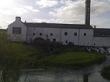
Kilbeggan Distillery
, standing on the banks of the River Brosna, commenced whiskey production in 1757. Within the distillery complex, the owner constructed a house and gardens on an island in the river. A member of the Locke family established the Convent of Mercy in the town in 1879.
A branch of the Grand Canal
, between Dublin and the River Shannon, served the town, opening in 1835.
The canal branch closed in the 1960s and the basin is now dry. The harbour buildings, however, have survived and are now in use as offices and workspace.
Although whiskey production ended at Locke's Distillery in the 1950s, the buildings survived and were reopened as a visitor attraction. Distillation has recently recommenced.
Kilbeggan Racecourse is around 1 kilometre north of the town. It is Ireland's only all-National Hunt course.
Kilbeggan is home to Mercy Secondary School, which stands on the Dublin Road. It is linked to the Mercy Convent, situated in the town.
Durrow Abbey
is located around 4 kilometres south of the town, just across the county boundary with Offaly.
County Westmeath
-Economy:Westmeath has a strong agricultural economy. Initially, development occurred around the major market centres of Mullingar, Moate, and Kinnegad. Athlone developed due to its military significance, and its strategic location on the main Dublin–Galway route across the River Shannon. Mullingar...
, Ireland
Republic of Ireland
Ireland , described as the Republic of Ireland , is a sovereign state in Europe occupying approximately five-sixths of the island of the same name. Its capital is Dublin. Ireland, which had a population of 4.58 million in 2011, is a constitutional republic governed as a parliamentary democracy,...
.
Geography
Kilbeggan is situated on the River BrosnaRiver Brosna
The River Brosna is a river in Ireland, flowing through County Westmeath and County Offaly.The river rises in Lough Owel north of Mullingar and is a tributary of the River Shannon. It meets the Shannon at Shannon Harbour.-Course:...
, in the south of County Westmeath. It lies southeast of Lough Ennell
Lough Ennell
Lough Ennell is a lake near the town of Mullingar, County Westmeath, Ireland. It is situated beside the N52 road, off the Mullingar/Kilbeggan road. It is approximately 4.5 miles long by 2 miles wide, with an area of about...
, north of the boundary with County Offaly
County Offaly
County Offaly is a county in Ireland. It is part of the Midlands Region and is also located in the province of Leinster. It is named after the ancient Kingdom of Uí Failghe and was formerly known as King's County until the establishment of the Irish Free State in 1922. Offaly County Council is...
, about 9 kilometres north of Tullamore
Tullamore
Tullamore is a town in County Offaly, in the midlands of Ireland. It is Offaly's county town and the centre of the district.Tullamore is an important commercial and industrial centre in the region. Major international employers in the town include 'Tyco Healthcare' and 'Boston Scientific'. In...
. Kilbeggan is surrounded by the gently rolling Esker Riada
Esker Riada
Esker Riada, , is a system of ridges that stretch across the middle of Ireland, between Dublin and Galway.-Geography:The Esker Riada is a collection of eskers, that passes through the counties of Dublin, Meath, Kildare, Westmeath, Offaly, Roscommon and Galway...
, the linear sand hills that stretch across the Irish midlands, which were left by retreating glaciers at the end of the last ice age. It is famous as the location of the oldest recorded incidence of a tornado in Europe.
Transport
The N6 - the main route between Dublin and GalwayGalway
Galway or City of Galway is a city in County Galway, Republic of Ireland. It is the sixth largest and the fastest-growing city in Ireland. It is also the third largest city within the Republic and the only city in the Province of Connacht. Located on the west coast of Ireland, it sits on the...
- originally passed through Kilbeggan, meeting the N52
N52 road (Ireland)
The N52 road is a national secondary road in Ireland. It links the M7 motorway from just south of Nenagh, County Tipperary to the M1 motorway north of Dundalk in County Louth.The road is long.-Quality of Road:...
in the town centre. Both the N6 and N52 have been re-routed to bypass the town to the south, with the road through the centre now reclassified as the R446
R446 road
The R446 road is one of Ireland's newest regional roads, having been classified following the opening in 2006 of the N6 High Quality Dual Carriageway which by-passes the old route....
regional road.
Regular buses between Dublin and Galway call at the town, with some services also operating to Tullamore. The nearest rail services operate from Clara, Tullamore and Mullingar
Mullingar
Mullingar is the county town of County Westmeath in Ireland. The Counties of Meath and Westmeath Act of 1542, proclaimed Westmeath a county, separating it from Meath. Mullingar became the administrative centre for County Westmeath...
.
History
St Bécán, one of the 'Twelve Apostles of Ireland', founded a monastery here in the 6th century, giving rise to the town's Irish name Cill Bheagáin, meaning "the church of St Bécán". In time the monastery fell into disuse and disrepair. A new monastery was founded on the site in 1150, by a member of the Mac Coghlan family, the ruins of the previous one having been rebuilt by the Dalton family. It was subsequently home to Cistercian monks from Mellifont AbbeyMellifont Abbey
Mellifont Abbey , located in County Louth, was the first Cistercian abbey to be built in Ireland.-Origins:Founded in 1142 on the orders of Saint Malachy, Archbishop of Armagh, Mellifont Abbey sits on the banks of the River Mattock, some ten km north-west of Drogheda.By 1170, Mellifont had one...
. The great priest of Clonmacnois, O'Catharnaigh (O'Kearney), died at the monastery in 1196 and Hugh O'Malone, Bishop of Clonmacnois, was buried there in 1236. In 1217 the monastery was involved in the riot of Jerpoint, and the abbot was punished as a result. Following the Conspiracy of Mellifont, the monastery was made subject to Buildwas Abbey
Buildwas Abbey
Buildwas Abbey is located along the banks of the River Severn in Buildwas, Shropshire, England, about two miles west of Ironbridge.-Early history:...
. After its dissolution in 1539, the monastery and its extensive lands were granted to the Lambart family
Earl of Cavan
Earl of Cavan is a title in the Peerage of Ireland. It was created in 1647 for Charles Lambart, 2nd Baron Lambart. He was made Viscount Kilcoursie, in the King's County, at the same time, also in the Peerage of Ireland...
. The monastery church was subsequently rebuilt with an added a bell tower. It served as the parish church for the reformed Church of Ireland. The church is no longer in use. The tower survives, in a ruinous state, surrounded by the churchyard, the town's burial ground.
A ford crossing the River Brosna at Kilbeggan was the site, in 972, of a battle between the Danes and the Irish. A skirmish led by the United Irishmen took place in the town, as part of the Irish Rebellion of 1798
Irish Rebellion of 1798
The Irish Rebellion of 1798 , also known as the United Irishmen Rebellion , was an uprising in 1798, lasting several months, against British rule in Ireland...
The Lambart family came to be politically dominant in and around Kilbeggan. Sir Oliver Lambart was made Governor of Connaught in 1601 and was subsequently granted 700 acres (2.8 km²) of land and 60 houses. Lambart inaugurated a weekly market in the town in 1606, and Kilbeggan became a borough town by charter of James I
James I of England
James VI and I was King of Scots as James VI from 24 July 1567 and King of England and Ireland as James I from the union of the English and Scottish crowns on 24 March 1603...
in 1612. Kilbeggan's market became important to the surrounding agricultural community. The substantial market house still stands in the town, though no longer used for its original purpose.
Kilbeggan Distillery
Kilbeggan Distillery
Kilbeggan Distillery is situated on the River Brosna in Kilbeggan, County Westmeath, Ireland....
, standing on the banks of the River Brosna, commenced whiskey production in 1757. Within the distillery complex, the owner constructed a house and gardens on an island in the river. A member of the Locke family established the Convent of Mercy in the town in 1879.
A branch of the Grand Canal
Grand Canal of Ireland
The Grand Canal is the southernmost of a pair of canals that connect Dublin, in the east of Ireland, with the River Shannon in the west,via Tullamore and a number of other villages and towns, the two canals nearly encircling Dublin's inner city. Its sister canal on the Northside of Dublin is the...
, between Dublin and the River Shannon, served the town, opening in 1835.
21st century
Today, the town serves as a service centre for the local farming community; hosts some light industry, including sand and gravel extraction in the surrounding area; and is seen increasingly as a Dublin commuter town, particularly since the improvement of the N6/M6 and the extension of the M4 motorway west of the city.The canal branch closed in the 1960s and the basin is now dry. The harbour buildings, however, have survived and are now in use as offices and workspace.
Although whiskey production ended at Locke's Distillery in the 1950s, the buildings survived and were reopened as a visitor attraction. Distillation has recently recommenced.
Kilbeggan Racecourse is around 1 kilometre north of the town. It is Ireland's only all-National Hunt course.
Kilbeggan is home to Mercy Secondary School, which stands on the Dublin Road. It is linked to the Mercy Convent, situated in the town.
Durrow Abbey
Durrow Abbey
Durrow Abbey is a historic site located off the N52 some 5 miles from Tullamore, County Offaly, Ireland.To this day, Durrow Abbey remains a largely undisturbed early historic and medieval monastic site containing a complex of archaeological monuments, ecclesiastical and secular, visible and...
is located around 4 kilometres south of the town, just across the county boundary with Offaly.
See also
- List of towns and villages in Ireland
- Market Houses in IrelandMarket Houses in the Republic of IrelandMarket houses are a notable feature of many Irish towns with varying styles of architecture, size and ornamentation making for a most interesting feature of the streetscape. Originally there were three, four or even five bays on the ground floor which were an open arcade. An upper floor was...