Higby Mountain
Encyclopedia
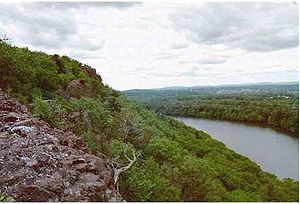
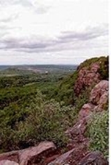
Higby Mountain or Mount Higby 892 feet (271.9 m), is a traprock mountain ridge located 3.75 miles (6 km) east of Meriden, Connecticut
. It is part of the narrow, linear Metacomet Ridge
that extends from Long Island Sound
near New Haven, Connecticut
, north through the Connecticut River Valley of Massachusetts
to the Vermont
border. Higby Mountain is known for its high cliff faces, unique microclimate
ecosystems, and rare plant communities. It rises steeply 600 feet (182.9 m) above the Quinnipiac River
valley and the city of Meriden to the west as a continuous 2 miles (3 km) long ledge. The mountain is traversed by the 50 miles (80.5 km) Mattabesett Trail
.
, Meriden
, and Middlefield
, Higby Mountain is 3 miles (4.8 km) long by 1.2 miles (1.9 km) wide at its widest point, although rugged topography makes the actual square mileage much larger. Higby Mountain is an important aquifer
; two reservoirs and one pond lie at the base of it: Higby Mountain Reservoir at its east foot; Adder Reservoir, on the upper eastern slope; and Black Pond between Besek Mountain and Higby Mountain. The mountain forms a conspicuous, sharp 2 miles (3 km) long cliffline visible throughout the upper Quinnipiac River Valley and metropolitan Meriden. Camel's Hump, est. 750 feet (228.6 m), also called The Pinnacle is a prominent southern high point on the ridge just above a shallow gap called Preston Notch. (The Pinnacle should not be confused with a similarly named peak on Talcott Mountain
, or with Pinnacle Rock
of Farmington, Connecticut
, both part of the Metacomet Ridge to the north of Higby Mountain). Interstate 91
cuts through the gap between Higby Mountain and Chauncey Peak
to the north.
The Metacomet Ridge continues northwest from Higby Mountain as Chauncey Peak and south as Besek Mountain
. A line of smaller hills extends from the Higby Mountain ridgeline north into Middletown; most notable of these is Fall Hill from which tumbles the 50 feet (15.2 m) high Westfield Falls, visible from Interstate 91 just north of Higby Mountain. The north and east sides of Higby Mountain drain into Fall Brook, then Sawmill Brook, then the Mattabesett River, thence to the Connecticut River
and Long Island Sound. The west and south side drain into Harbor Brook thence into the Quinnipiac River and Long Island Sound.
, also called traprock, a volcanic rock. The mountain formed near the end of the Triassic Period with the rifting apart of the North America
n continent from Africa
and Eurasia
. Lava
welled up from the rift and solidified into sheets of strata hundreds of feet thick. Subsequent faulting and earthquake
activity tilted the strata, creating the cliffs and ridgeline of Higby Mountain. Hot, dry upper slopes, cool, moist ravines, and mineral-rich ledges of basalt talus
produce a combination of microclimate
ecosystems on the mountain that support plant and animal species uncommon in greater Connecticut. Higby Mountain is also an important raptor migration path. (See Metacomet Ridge
for more information on the geology and ecosystem of Higby Mountain).
, snowshoeing, bird watching picnicking, and other passive pursuits. Swimming, boating
, and fishing
are prohibited in the reservoirs but fishing and boating are allowed on Black Pond. The Mattabesett Trail (maintained by the Connecticut Forest and Park Association
), which stretches from the northern end of Lamentation Mountain
, south to Totoket Mountain
and north again to the Connecticut River, traverses the ridgeline of Higby Mountain. Higby Mountain has two trailheads. There is a roadside parking area at the south end of the mountain on the westbound side of Connecticut Route 66, 1.5 miles (2.4 km) east of Connecticut Route 15 in Meriden. The second trailhead is located at the north end of the mountain at the junction of Miner Steet and Interstate 91
, exit 20 in Middletown; parking is permitted along the road. Black Pond can be accessed via a small parking lot off East Main Street in Meriden, 1.2 miles (1.9 km) east of Connecticut Route 15.
The Nature Conservancy
maintains a 158 acres (63.9 ha) reservation on the south ridgeline of Higby Mountain. The town of Middletown owns part of the mountain, both as open space and as watershed. Black Pond, undeveloped and scenic, is part of the Black Pond Wildlife Management Area.
Threats to the ecosystem and ridgeline of Higby Mountain include development and quarrying. In 2000, Higby Mountain was included in a study by the National Park Service
for the designation of a new National Scenic Trail
now tentatively called the New England National Scenic Trail
, which would include the Metacomet-Monadnock Trail
in Massachusetts and the Mattabesett Trail
and Metacomet Trail
trails in Connecticut.
The Meriden Land Trust and the Middlesex Land Trust have been active in conserving the viewshed
of Higby Mountain.
Meriden, Connecticut
Meriden is a city in New Haven County, Connecticut, United States. According to 2005 Census Bureau estimates, the population of the city is 59,653.-History:...
. It is part of the narrow, linear Metacomet Ridge
Metacomet Ridge
The Metacomet Ridge, Metacomet Ridge Mountains, or Metacomet Range of southern New England, United States, is a narrow and steep fault-block mountain ridge known for its extensive cliff faces, scenic vistas, microclimate ecosystems, and communities of plants considered rare or endangered...
that extends from Long Island Sound
Long Island Sound
Long Island Sound is an estuary of the Atlantic Ocean, located in the United States between Connecticut to the north and Long Island, New York to the south. The mouth of the Connecticut River at Old Saybrook, Connecticut, empties into the sound. On its western end the sound is bounded by the Bronx...
near New Haven, Connecticut
New Haven, Connecticut
New Haven is the second-largest city in Connecticut and the sixth-largest in New England. According to the 2010 Census, New Haven's population increased by 5.0% between 2000 and 2010, a rate higher than that of the State of Connecticut, and higher than that of the state's five largest cities, and...
, north through the Connecticut River Valley of Massachusetts
Massachusetts
The Commonwealth of Massachusetts is a state in the New England region of the northeastern United States of America. It is bordered by Rhode Island and Connecticut to the south, New York to the west, and Vermont and New Hampshire to the north; at its east lies the Atlantic Ocean. As of the 2010...
to the Vermont
Vermont
Vermont is a state in the New England region of the northeastern United States of America. The state ranks 43rd in land area, , and 45th in total area. Its population according to the 2010 census, 630,337, is the second smallest in the country, larger only than Wyoming. It is the only New England...
border. Higby Mountain is known for its high cliff faces, unique microclimate
Microclimate
A microclimate is a local atmospheric zone where the climate differs from the surrounding area. The term may refer to areas as small as a few square feet or as large as many square miles...
ecosystems, and rare plant communities. It rises steeply 600 feet (182.9 m) above the Quinnipiac River
Quinnipiac River
The Quinnipiac River is a river in the New England region of the United States, located entirely in the state of Connecticut.It rises in west central Connecticut from Dead Wood Swamp west of the city of New Britain...
valley and the city of Meriden to the west as a continuous 2 miles (3 km) long ledge. The mountain is traversed by the 50 miles (80.5 km) Mattabesett Trail
Mattabesett Trail
The Mattabesett Trail is a long, hook-shaped Blue-Blazed hiking trail in central Connecticut and a part of the newly designated New England National Scenic Trail. One half of the trail follows the high traprock ridges of the Metacomet Ridge, from Totoket Mountain in Guilford, Connecticut to...
.
Geography
Located within the towns of MiddletownMiddletown, Connecticut
Middletown is a city located in Middlesex County, Connecticut, along the Connecticut River, in the central part of the state, 16 miles south of Hartford. In 1650, it was incorporated as a town under its original Indian name, Mattabeseck. It received its present name in 1653. In 1784, the central...
, Meriden
Meriden, Connecticut
Meriden is a city in New Haven County, Connecticut, United States. According to 2005 Census Bureau estimates, the population of the city is 59,653.-History:...
, and Middlefield
Middlefield, Connecticut
Middlefield is a town in Middlesex County, Connecticut, United States. The population was 4,203 at the 2000 census. The town includes the village of Rockfall-History:...
, Higby Mountain is 3 miles (4.8 km) long by 1.2 miles (1.9 km) wide at its widest point, although rugged topography makes the actual square mileage much larger. Higby Mountain is an important aquifer
Aquifer
An aquifer is a wet underground layer of water-bearing permeable rock or unconsolidated materials from which groundwater can be usefully extracted using a water well. The study of water flow in aquifers and the characterization of aquifers is called hydrogeology...
; two reservoirs and one pond lie at the base of it: Higby Mountain Reservoir at its east foot; Adder Reservoir, on the upper eastern slope; and Black Pond between Besek Mountain and Higby Mountain. The mountain forms a conspicuous, sharp 2 miles (3 km) long cliffline visible throughout the upper Quinnipiac River Valley and metropolitan Meriden. Camel's Hump, est. 750 feet (228.6 m), also called The Pinnacle is a prominent southern high point on the ridge just above a shallow gap called Preston Notch. (The Pinnacle should not be confused with a similarly named peak on Talcott Mountain
Talcott Mountain
Talcott Montain of central Connecticut, with a high point of , is a long trap rock mountain ridge located west of the city of Hartford. The ridge, a prominent landscape feature, forms a continuous line of exposed western cliffs visible across the Farmington River valley from Farmington to Simsbury...
, or with Pinnacle Rock
Pinnacle Rock (Connecticut)
Pinnacle Rock, , is a traprock mountain peak located southwest of Hartford, Connecticut in the towns of Farmington and Plainville.It is part of the narrow, linear Metacomet Ridge that extends from Long Island Sound near New Haven, Connecticut, north through the Connecticut River Valley of...
of Farmington, Connecticut
Farmington, Connecticut
Farmington is a town located in Hartford County in the Farmington Valley area of central Connecticut in the United States. The population was 25,340 at the 2010 census. It is home to the world headquarters of several large corporations including Carrier Corporation, Otis Elevator Company, and Carvel...
, both part of the Metacomet Ridge to the north of Higby Mountain). Interstate 91
Interstate 91
Interstate 91 is an Interstate Highway in the New England region of the United States. It provides the primary north–south thoroughfare in the western part of New England...
cuts through the gap between Higby Mountain and Chauncey Peak
Chauncey Peak
Chauncey Peak, , is a traprock mountain located 2 miles northeast of the center of Meriden, Connecticut. It is part of the narrow, linear Metacomet Ridge that extends from Long Island Sound near New Haven, Connecticut, north through the Connecticut River Valley of Massachusetts to the Vermont border...
to the north.
The Metacomet Ridge continues northwest from Higby Mountain as Chauncey Peak and south as Besek Mountain
Besek Mountain
Besek Mountain also known as Black Mountain, est. , is a traprock mountain ridge located southeast of Meriden, Connecticut. It is part of the narrow, linear Metacomet Ridge that extends from Long Island Sound near New Haven, Connecticut, north through the Connecticut River Valley of Massachusetts...
. A line of smaller hills extends from the Higby Mountain ridgeline north into Middletown; most notable of these is Fall Hill from which tumbles the 50 feet (15.2 m) high Westfield Falls, visible from Interstate 91 just north of Higby Mountain. The north and east sides of Higby Mountain drain into Fall Brook, then Sawmill Brook, then the Mattabesett River, thence to the Connecticut River
Connecticut River
The Connecticut River is the largest and longest river in New England, and also an American Heritage River. It flows roughly south, starting from the Fourth Connecticut Lake in New Hampshire. After flowing through the remaining Connecticut Lakes and Lake Francis, it defines the border between the...
and Long Island Sound. The west and south side drain into Harbor Brook thence into the Quinnipiac River and Long Island Sound.
Geology and ecology
Higby Mountain, like much of the Metacomet Ridge, is composed of basaltBasalt
Basalt is a common extrusive volcanic rock. It is usually grey to black and fine-grained due to rapid cooling of lava at the surface of a planet. It may be porphyritic containing larger crystals in a fine matrix, or vesicular, or frothy scoria. Unweathered basalt is black or grey...
, also called traprock, a volcanic rock. The mountain formed near the end of the Triassic Period with the rifting apart of the North America
North America
North America is a continent wholly within the Northern Hemisphere and almost wholly within the Western Hemisphere. It is also considered a northern subcontinent of the Americas...
n continent from Africa
Africa
Africa is the world's second largest and second most populous continent, after Asia. At about 30.2 million km² including adjacent islands, it covers 6% of the Earth's total surface area and 20.4% of the total land area...
and Eurasia
Eurasia
Eurasia is a continent or supercontinent comprising the traditional continents of Europe and Asia ; covering about 52,990,000 km2 or about 10.6% of the Earth's surface located primarily in the eastern and northern hemispheres...
. Lava
Lava
Lava refers both to molten rock expelled by a volcano during an eruption and the resulting rock after solidification and cooling. This molten rock is formed in the interior of some planets, including Earth, and some of their satellites. When first erupted from a volcanic vent, lava is a liquid at...
welled up from the rift and solidified into sheets of strata hundreds of feet thick. Subsequent faulting and earthquake
Earthquake
An earthquake is the result of a sudden release of energy in the Earth's crust that creates seismic waves. The seismicity, seismism or seismic activity of an area refers to the frequency, type and size of earthquakes experienced over a period of time...
activity tilted the strata, creating the cliffs and ridgeline of Higby Mountain. Hot, dry upper slopes, cool, moist ravines, and mineral-rich ledges of basalt talus
Scree
Scree, also called talus, is a term given to an accumulation of broken rock fragments at the base of crags, mountain cliffs, or valley shoulders. Landforms associated with these materials are sometimes called scree slopes or talus piles...
produce a combination of microclimate
Microclimate
A microclimate is a local atmospheric zone where the climate differs from the surrounding area. The term may refer to areas as small as a few square feet or as large as many square miles...
ecosystems on the mountain that support plant and animal species uncommon in greater Connecticut. Higby Mountain is also an important raptor migration path. (See Metacomet Ridge
Metacomet Ridge
The Metacomet Ridge, Metacomet Ridge Mountains, or Metacomet Range of southern New England, United States, is a narrow and steep fault-block mountain ridge known for its extensive cliff faces, scenic vistas, microclimate ecosystems, and communities of plants considered rare or endangered...
for more information on the geology and ecosystem of Higby Mountain).
Recreation and conservation
Activities enjoyed on the mountain include hikingHiking
Hiking is an outdoor activity which consists of walking in natural environments, often in mountainous or other scenic terrain. People often hike on hiking trails. It is such a popular activity that there are numerous hiking organizations worldwide. The health benefits of different types of hiking...
, snowshoeing, bird watching picnicking, and other passive pursuits. Swimming, boating
Boating
Boating is the leisurely activity of travelling by boat, or the recreational use of a boat whether powerboats, sailboats, or man-powered vessels , focused on the travel itself, as well as sports activities, such as fishing or water skiing...
, and fishing
Fishing
Fishing is the activity of trying to catch wild fish. Fish are normally caught in the wild. Techniques for catching fish include hand gathering, spearing, netting, angling and trapping....
are prohibited in the reservoirs but fishing and boating are allowed on Black Pond. The Mattabesett Trail (maintained by the Connecticut Forest and Park Association
Connecticut Forest and Park Association
The Connecticut Forest and Park Association , established in 1895, is the oldest private, nonprofit conservation organization in Connecticut. The organization is credited as an important early pioneer of the national land conservation movement and as an early advocate of long distance trail building...
), which stretches from the northern end of Lamentation Mountain
Lamentation Mountain
Lamentation Mountain, or Mount Lamentation, , is a traprock mountain located north of Meriden, Connecticut. It is part of the narrow, linear Metacomet Ridge that extends from Long Island Sound near New Haven, Connecticut, north through the Connecticut River Valley of Massachusetts to the Vermont...
, south to Totoket Mountain
Totoket Mountain
Totoket Mountain, with a high point of above sea level, is a traprock massif with several distinct summits, located northeast of New Haven, Connecticut. It is part of the Metacomet Ridge that extends from Long Island Sound near New Haven, north through the Connecticut River Valley of...
and north again to the Connecticut River, traverses the ridgeline of Higby Mountain. Higby Mountain has two trailheads. There is a roadside parking area at the south end of the mountain on the westbound side of Connecticut Route 66, 1.5 miles (2.4 km) east of Connecticut Route 15 in Meriden. The second trailhead is located at the north end of the mountain at the junction of Miner Steet and Interstate 91
Interstate 91
Interstate 91 is an Interstate Highway in the New England region of the United States. It provides the primary north–south thoroughfare in the western part of New England...
, exit 20 in Middletown; parking is permitted along the road. Black Pond can be accessed via a small parking lot off East Main Street in Meriden, 1.2 miles (1.9 km) east of Connecticut Route 15.
The Nature Conservancy
The Nature Conservancy
The Nature Conservancy is a US charitable environmental organization that works to preserve the plants, animals, and natural communities that represent the diversity of life on Earth by protecting the lands and waters they need to survive....
maintains a 158 acres (63.9 ha) reservation on the south ridgeline of Higby Mountain. The town of Middletown owns part of the mountain, both as open space and as watershed. Black Pond, undeveloped and scenic, is part of the Black Pond Wildlife Management Area.
Threats to the ecosystem and ridgeline of Higby Mountain include development and quarrying. In 2000, Higby Mountain was included in a study by the National Park Service
National Park Service
The National Park Service is the U.S. federal agency that manages all national parks, many national monuments, and other conservation and historical properties with various title designations...
for the designation of a new National Scenic Trail
National Scenic Trail
National Scenic Trail is a designation for protected areas in the United States that consist of trails of particular natural beauty.National Scenic Trails were authorized under the National Trails System Act of 1968 along with National Historic Trails and National Recreation Trails...
now tentatively called the New England National Scenic Trail
New England National Scenic Trail
The New England National Scenic Trail is a National Scenic Trail in southern New England, which includes most of the three single trails Metacomet-Monadnock Trail, Mattabesett Trail and Metacomet Trail. After the Metacomet-Monadnock-Mattabesett trail system, the trail is sometimes called Triple-M...
, which would include the Metacomet-Monadnock Trail
Metacomet-Monadnock Trail
The Metacomet-Monadnock Trail is a hiking trail that traverses the Metacomet Ridge of the Pioneer Valley region of Massachusetts and the central uplands of Massachusetts and southern New Hampshire...
in Massachusetts and the Mattabesett Trail
Mattabesett Trail
The Mattabesett Trail is a long, hook-shaped Blue-Blazed hiking trail in central Connecticut and a part of the newly designated New England National Scenic Trail. One half of the trail follows the high traprock ridges of the Metacomet Ridge, from Totoket Mountain in Guilford, Connecticut to...
and Metacomet Trail
Metacomet Trail
The Metacomet Trail is a Blue-Blazed hiking trail that traverses the Metacomet Ridge of central Connecticut and is a part of the newly designated New England National Scenic Trail. Despite being easily accessible and close to large population centers, the trail is considered remarkably rugged and...
trails in Connecticut.
The Meriden Land Trust and the Middlesex Land Trust have been active in conserving the viewshed
Viewshed
A viewshed is an area of land, water, or other environmental element that is visible to the human eye from a fixed vantage point. The term is used widely in such areas as urban planning, archaeology, and military science...
of Higby Mountain.
See also
- Metacomet RidgeMetacomet RidgeThe Metacomet Ridge, Metacomet Ridge Mountains, or Metacomet Range of southern New England, United States, is a narrow and steep fault-block mountain ridge known for its extensive cliff faces, scenic vistas, microclimate ecosystems, and communities of plants considered rare or endangered...
- Adjacent summits:
↓ South North ↑