

Connecticut Forest and Park Association
Encyclopedia
Connecticut
Connecticut is a state in the New England region of the northeastern United States. It is bordered by Rhode Island to the east, Massachusetts to the north, and the state of New York to the west and the south .Connecticut is named for the Connecticut River, the major U.S. river that approximately...
. The organization is credited as an important early pioneer of the national land conservation movement and as an early advocate of long distance trail building. The mission of the CFPA is “to conserve the land, trails, and natural resources of Connecticut. The CFPA established and maintains the 700-mile Blue-Blazed Trails Hiking Trail system and has been instrumental in acquiring more than 100 state parks and forests across Connecticut.
The organization publishes guidebooks and maps, conducts ecological surveys, provides advice on sustainable forestry, advocates for land conservation, maintains and builds trails, and conducts a variety of educational programs for adults and children. It publishes the “Connecticut Walk Book East” and “Connecticut Walk Book West” for their Blue-Blazed Trails in Eastern and Western Connecticut that are available at many public libraries.
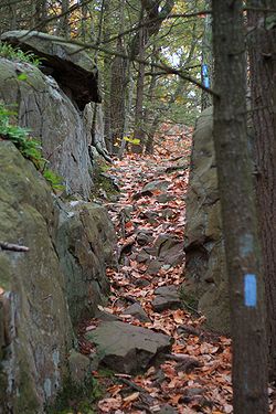
Blue-Blazed Trails
The CFPA established the Blue-Blazed Hiking Trail SystemBlue-Blazed Trails
The Blue-Blazed trail system, managed by the Connecticut Forest and Park Association, and the related trail systems documented in the two volume 19th Edition of the "Connecticut Walk Book" comprise over 800 miles of hiking trails in Connecticut.There are now over 825 miles of CFPA Blue-Blazed...
in 1929, when the Quinnipiac Trail
Quinnipiac Trail
The Quinnipiac Trail is a Blue-Blazed hiking trail in New Haven County, Connecticut. It is the product of the evolution and growth of the first trail designated in Connecticut's Blue-Blazed Hiking Trail system, with its light-blue rectangular vertical painted blazes .-The route:From its...
was created. This trail system includes over 830 miles of Blue-Blazed Trails that pass through 88 towns traversing both public and private lands.
Notable trails managed by the CFPA include the Quinnipiac
Quinnipiac Trail
The Quinnipiac Trail is a Blue-Blazed hiking trail in New Haven County, Connecticut. It is the product of the evolution and growth of the first trail designated in Connecticut's Blue-Blazed Hiking Trail system, with its light-blue rectangular vertical painted blazes .-The route:From its...
, Regicides
Regicides Trail
Regicides Trail is a Blue-Blazed hiking trail, about 7 miles long, roughly following the edge of a basalt, or traprock, cliff northwest of New Haven, Connecticut. It is named for two regicides, Edward Whalley and his son-in-law William Goffe, who signed the death warrant of King Charles I of England...
, Nipmuck, Mohawk, Tunxis
Tunxis Trail
The Tunxis Trail is a Blue-Blazed hiking trail "system" that traverses the western ridge of the central Connecticut valley. The mainline trail is not completely contiguous, notably there are two gaps of several miles .The Tunxis Trail is...
, Mattatuck, and Shenipsit
Shenipsit Trail
The Shenipsit Trail is a Blue-Blazed hiking trail located in Central Connecticut between 3.5 and 7 miles east of the Connecticut River. It runs 41 miles in a north-south direction. The southern trailhead is on Gadpouch Road in Cobalt, CT on the southern end of the Meshomasic State Forest...
Trails. The Metacomet
Metacomet Trail
The Metacomet Trail is a Blue-Blazed hiking trail that traverses the Metacomet Ridge of central Connecticut and is a part of the newly designated New England National Scenic Trail. Despite being easily accessible and close to large population centers, the trail is considered remarkably rugged and...
and Mattabesett
Mattabesett Trail
The Mattabesett Trail is a long, hook-shaped Blue-Blazed hiking trail in central Connecticut and a part of the newly designated New England National Scenic Trail. One half of the trail follows the high traprock ridges of the Metacomet Ridge, from Totoket Mountain in Guilford, Connecticut to...
Trails are part of the New England National Scenic Trail
New England National Scenic Trail
The New England National Scenic Trail is a National Scenic Trail in southern New England, which includes most of the three single trails Metacomet-Monadnock Trail, Mattabesett Trail and Metacomet Trail. After the Metacomet-Monadnock-Mattabesett trail system, the trail is sometimes called Triple-M...
, also referred to as Triple-M Trail. This 220 mile route extends from Long Island Sound
Long Island Sound
Long Island Sound is an estuary of the Atlantic Ocean, located in the United States between Connecticut to the north and Long Island, New York to the south. The mouth of the Connecticut River at Old Saybrook, Connecticut, empties into the sound. On its western end the sound is bounded by the Bronx...
to Mount Monadnock
Mount Monadnock
Mount Monadnock, or Grand Monadnock, is the most prominent New England mountain peak south of the White Mountains and east of the Massachusetts Berkshires, and is the highest point in Cheshire County, New Hampshire...
in Southern New Hampshire
New Hampshire
New Hampshire is a state in the New England region of the northeastern United States of America. The state was named after the southern English county of Hampshire. It is bordered by Massachusetts to the south, Vermont to the west, Maine and the Atlantic Ocean to the east, and the Canadian...
.