

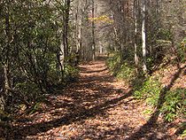
Hazel Creek (Great Smoky Mountains)
Encyclopedia

Little Tennessee River
The Little Tennessee River is a tributary of the Tennessee River, approximately 135 miles long, in the Appalachian Mountains in the southeastern United States.-Geography:...
in the southwestern Great Smoky Mountains
Great Smoky Mountains
The Great Smoky Mountains are a mountain range rising along the Tennessee–North Carolina border in the southeastern United States. They are a subrange of the Appalachian Mountains, and form part of the Blue Ridge Physiographic Province. The range is sometimes called the Smoky Mountains or the...
of North Carolina
North Carolina
North Carolina is a state located in the southeastern United States. The state borders South Carolina and Georgia to the south, Tennessee to the west and Virginia to the north. North Carolina contains 100 counties. Its capital is Raleigh, and its largest city is Charlotte...
. The creek's bottomlands were home to several pioneer Appalachia
Appalachia
Appalachia is a term used to describe a cultural region in the eastern United States that stretches from the Southern Tier of New York state to northern Alabama, Mississippi, and Georgia. While the Appalachian Mountains stretch from Belle Isle in Canada to Cheaha Mountain in the U.S...
n communities and logging towns before its incorporation into the Great Smoky Mountains National Park
Great Smoky Mountains National Park
Great Smoky Mountains National Park is a United States National Park and UNESCO World Heritage Site that straddles the ridgeline of the Great Smoky Mountains, part of the Blue Ridge Mountains, which are a division of the larger Appalachian Mountain chain. The border between Tennessee and North...
. Hazel Creek is now a back country campsite and historical area.
Geography

Silers Bald
Silers Bald is a mountain in the western Great Smoky Mountains, located in theSoutheastern United States. Its proximity to Clingmans Dome and its location alongthe Appalachian Trail make it a popular hiking destination....
to its mouth along the Fontana impoundment
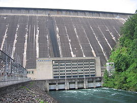
Fontana Dam
Fontana Dam is a hydroelectric dam on the Little Tennessee River in Swain and Graham counties, North Carolina, USA. The dam is operated by the Tennessee Valley Authority, which built the dam in the early 1940s to accommodate the skyrocketing electricity demands in the Tennessee Valley at the...
of the Little Tennessee River, a journey of roughly 18 miles (29 km). The creek drains the area between Welch Ridge to the east and Jenkins Trail Ridge to the west. Both Welch and Jenkins, which run perpendicular to the crest of the Smokies, reach elevations of over 5000 feet (1,524 m) for considerable stretches. Two smaller ridges— the Pinnacle and Locust Ridge— parallel Hazel's northern banks, dividing the creek's valley from its upper watershed. Hazel Creek is one of three major watersheds in the southwestern Smokies, the others being Eagle Creek (on the other side of Jenkins Trail Ridge to the west) and Forney Creek (on the other side of Welch Ridge to the east). These three watersheds comprise the remote, roadless northern banks of Fontana Lake known locally as the North Shore.
From its source near the Silers Bald Shelter, Hazel Creek drops 1500 feet (457.2 m) in just under 1 miles (2 km) before steadying at its confluence with Proctor Creek. 5 miles (8 km) from its source, the creek absorbs Walkers Creek and five smaller streams as it winds its way between two steep knobs known as High Rocks (to the south) and Raven Den (to the north). At the southwestern base of Locust Ridge, the creek absorbs Bone Valley Creek and Sugar Fork before turning sharply to the south and winding its way around the southern base of the Pinnacle. Just before reaching Proctor, the creek turns north and south again at a bend known as "the Horseshoe." At Proctor, Hazel Creek absorbs Shehan Branch before emptying into its Fontana Lake embayment. Northwest of Proctor, Shehan Branch slices a narrow valley known as Possum Hollow.
There are no public roads leading into the Hazel Creek valley. Fontana Village, which provides ferry access to the Hazel Creek Trail, is approximately 5 miles (8 km) east of the mouth of Hazel Creek on the other side of Fontana Lake. Along North Carolina State Route 28, Bryson City
Bryson City, North Carolina
Bryson City is a town in Swain County, North Carolina in the United States. The population was 1,353 as of 2009, a decrease of 4.1% since the 2000 census...
is just over 30 miles (48.3 km) east of Fontana. Along U.S. Route 129
U.S. Route 129
U.S. Route 129 is an offshoot route of U.S. Route 29, which it intersects near Athens, Georgia. US 129 currently runs for 582 miles from Knoxville, Tennessee, to Chiefland, Florida, at U.S. Route 19 and U.S. Route 98. It passes through the states of Tennessee, North Carolina, Georgia and Florida...
, Maryville, Tennessee
Maryville, Tennessee
Maryville is the county seat of Blount County, Tennessee, in the Southeastern United States. The city is located south of Knoxville. Maryville's population was 27,258 at the 2010 census. It is included in the Knoxville Metropolitan Area. Maryville has received a number of accolades for its...
is just over 45 miles (72.4 km) northwest of Fontana. Fontana is 11 miles (17.7 km) east of the state line at Deals Gap
Deals Gap, North Carolina
Deals Gap is a portion of U.S. Route 129 in Blount County, Tennessee, which also lends its name to a small unincorporated community and motorcycle resort situated in a gap in Swain County, North Carolina, United States. It is located along U.S. 129 at the Tennessee state line. The community has an...
. Hazel Creek is located entirely within Swain County, North Carolina
Swain County, North Carolina
Swain County is a county located in the U.S. state of North Carolina. As of 2000, the population was 12,968. Its county seat is Bryson City.Swain County is home of the Nantahala River . The Nantahala is one of the most popular whitewater rafting rivers in the nation...
.
Hazel Creek communities

Proctor — located at the confluence of Shehan Branch and Hazel Creek, between what is now Campsite 86 and the ruins of the Ritter Mill. Named after Hazel Creek's first settlers, Moses and Patience Proctor.
Cable Branch — located downstream from Proctor at the confluence of Hazel Creek and Cable Branch (now part of Hazel's embayment along Fontana). Cable Branch was named after Samuel Cable, who settled along the stream around 1835. The Fontana Marina's low-water Hazel Creek ferry rendezvous is located near the mouth of Cable Branch.
Medlin — located at the confluence of Hazel Creek and Sugar Fork, centered around what is now Campsite 84. Named after Marion Medlin, who settled in the vicinity in the 1860s.
Bone Valley — located at the confluence of Bone Valley Creek and Hazel Creek, in the vicinity of what is now Campsite 83. Named after the many bones left over from a cattle herd that froze to death in the valley, probably around 1888.
Ritter — located at the original confluence of Hazel Creek and the Little Tennessee River, now submerged under Fontana Lake. Named after the Ritter Lumber Company, which used the town as a railroad hub in the early 1900s.
Other important North Shore communities included Bushnell at the confluence of the Tuckasegee River and Little Tennessee River, Wayside at the mouth of Calhoun Creek, and Fontana at the mouth of Eagle Creek.
History

Cherokee
The Cherokee are a Native American people historically settled in the Southeastern United States . Linguistically, they are part of the Iroquoian language family...
were the first known permanent inhabitants of the Hazel Creek valley, although the valley was much more sparsely-populated than the Overhill
Overhill Cherokee
The term Overhill Cherokee refers to the former Cherokee settlements located in what is now Tennessee in the southeastern United States. The name was given by 18th century European traders and explorers who had to cross the Appalachian Mountains to reach these settlements when traveling from...
settlements further down the Little Tennessee valley. A small Cherokee village is known to have existed at the confluence of Sugar Fork and Hazel Creek, and at the time of the arrival of the first settlers, there were Cherokee families living in Possum Hollow. According to local lore, an unmarked Cherokee grave is located near Proctor.
A well-worn Cherokee trail connected Hazel Creek to Cades Cove
Cades Cove
Cades Cove is an isolated valley located in the Tennessee section of Great Smoky Mountains National Park, USA. The valley was home to numerous settlers before the formation of the national park...
on the Tennessee
Tennessee
Tennessee is a U.S. state located in the Southeastern United States. It has a population of 6,346,105, making it the nation's 17th-largest state by population, and covers , making it the 36th-largest by total land area...
side of the Smokies. The trail followed Shehan Branch, crossed the Pinnacle, and ascended Eagle Creek to Ekaneetlee Gap, a col just east of Gregory Bald
Gregory Bald
Gregory Bald is a mountain on the western fringe of the Great Smoky Mountains. It has an elevation of 4,949 feet above sea level. The mountain's majestic summit makes it a popular hiking destination....
at the crest, and descended into the cove. From Cades Cove, the trail proceeded to Tuckaleechee Cove and the Overhill settlements. Other less-used trails connected Hazel to Forney Creek on the other side of Welch Ridge to the east and the Tuckasegee River area around modern-day Bryson City.
Early settlement, 1829-1860

In 1835, Samuel Cable (c. 1795-1887) and his wife Elizabeth settled just downstream from the Proctors at the mouth of Cable Branch (named after them). This area is now part of the Hazel Creek embayment. Samuel's brother, Peter, was a prominent figure in the early history of Cades Cove, and his nephew, John P. Cable, built the large gristmill
Gristmill
The terms gristmill or grist mill can refer either to a building in which grain is ground into flour, or to the grinding mechanism itself.- Early history :...
that still stands near the Cades Cove Visitor Center. Both Cable and Proctor probably wanted to take advantage of an old cattle road that ran from the North Shore area to the Parsons Turnpike. The Turnpike connected Deal's Gap and Chilhowee, thus giving access to markets in Blount County
Blount County, Tennessee
Blount County is a U.S. county located in the U.S. state of Tennessee. Its population was 123,010 at the United States Census, 2010. The county seat is at Maryville, which is also the county's largest city....
and Knoxville.
Hazel Creek remained sparsely populated until the American Civil War
American Civil War
The American Civil War was a civil war fought in the United States of America. In response to the election of Abraham Lincoln as President of the United States, 11 southern slave states declared their secession from the United States and formed the Confederate States of America ; the other 25...
. Joseph Welch, who married the Proctors' daughter Catherine, settled on a small farm near his in-laws. In the 1850s, Josiah and Sarah Bradshaw established a small farm in the Proctor area. Shortly after arriving, the Bradshaws built Hazel Creek's first gristmill. The creek was given its name around this time, probably referring to the hazelnut
Hazelnut
A hazelnut is the nut of the hazel and is also known as a cob nut or filbert nut according to species. A cob is roughly spherical to oval, about 15–25 mm long and 10–15 mm in diameter, with an outer fibrous husk surrounding a smooth shell. A filbert is more elongated, being about twice...
bushes that lined its banks.
The Civil War, 1861-1865
Confederate States of America
The Confederate States of America was a government set up from 1861 to 1865 by 11 Southern slave states of the United States of America that had declared their secession from the U.S...
. This put them at odds with their cousins on the Tennessee side of the mountains in Cades Cove who were staunchly pro-Union
Union (American Civil War)
During the American Civil War, the Union was a name used to refer to the federal government of the United States, which was supported by the twenty free states and five border slave states. It was opposed by 11 southern slave states that had declared a secession to join together to form the...
. Union supporters fleeing Confederate North Carolina often fled to Cades Cove via Hazel Creek and Ekaneetlee Gap. Bushwhackers and vigilantes in Cades Cove and Hazel Creek launched raids against one another, usually to steal livestock and crops.
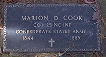
Two sons of Moses and Patience Proctor were killed fighting for the Confederate cause. A third son survived the war, but barely made it home. The community of Bone Valley was largely settled by Confederate veterans, 6 of whom are buried in Bone Valley Cemetery, above Campsite 83.
Mining and early logging, 1889-1901

In 1883, Jacob Fonslow Hall was visiting his brother Jesse when he discovered a copper vein on Little Fork Ridge, a few miles above the mouth of Sugar Fork. The Halls passed on the vein's location to Mark Bryson, a local prospector, who in turn notified New York entrepreneur W.S. Adams. In 1889, After inspecting the vein for himself, Adams immediately set up a mining camp on Little Fork, widened the trail from Sugar Fork to the mouth of Hazel Creek into a wagon road, and made plans to bring in a smelter. However, in 1901 a New Orleans land speculator named George Westfeldt sued Adams, claiming he actually owned the land on which mine was located. The legal quandary shut down the mine. After a 27-year legal battle, Adams was declared the rightful owner of the mine, although both he and Westfeldt were dead by the time the decision was handed down.
In 1892, a logging firm known as Taylor and Crate (some sources claim it was Johnson and Harris) sent its agent Jack Coburn to buy up timber rights along Hazel Creek. Lacking a railroad, Taylor and Crate used a series of splash dams to move logs in controlled floods downstream to the Little Tennessee, where they would then be floated to the Tennessee River
Tennessee River
The Tennessee River is the largest tributary of the Ohio River. It is approximately 652 miles long and is located in the southeastern United States in the Tennessee Valley. The river was once popularly known as the Cherokee River, among other names...
and eventually to a sawmill in Chattanooga
Chattanooga, Tennessee
Chattanooga is the fourth-largest city in the US state of Tennessee , with a population of 169,887. It is the seat of Hamilton County...
. Taylor and Crate never managed to turn a profit, however, and left the valley in 1898.
Horace Kephart, 1904-1907
Horace Kephart
Horace Kephart was an American travel writer and librarian, best known as the author of Our Southern Highlanders, about his life in the Great Smoky Mountains of western North Carolina.-Biography:...
, a librarian from St. Louis
St. Louis, Missouri
St. Louis is an independent city on the eastern border of Missouri, United States. With a population of 319,294, it was the 58th-largest U.S. city at the 2010 U.S. Census. The Greater St...
, arrived in Hazel Creek with plans to study the wilderness areas of the Southern Appalachian highlands. Kephart moved into a cabin at the old Adams mining camp just above Sugar Fork, about two miles (3 km) from Medlin. Kephart gave the following description of Medlin:
Medlin itself comprised two little stores built of rough planks and bearing no signs, a corn mill, and four dwellings. 1.5 miles (2 km) away was the log schoolhouse, which, once or twice a month, served also as a church. Scattered about the settlement were seven tiny tub mills for grinding corn..."
Kephart's book Our Southern Highlanders
Our Southern Highlanders
Our Southern Highlanders: A Narrative of Adventure In the Southern Appalachians and a Study of Life Among the Mountaineers is a book written by American author Horace Kephart , first published in 1913 and revised in 1922...
(published in 1913) was the first widely-read study of Southern Appalachian culture. The fourth chapter of the book, "A Bear Hunt In the Smokies," recounts a typical bear-hunting excursion to the crest of the Smokies. Three members of the hunting party— Granville Calhoun, "Little John" Cable, and "Doc" Jones— were children of early Hazel Creek pioneers. The hunting party stayed at a herding shack built by Jesse "Crate" Hall along the crest near Chestnut Bald. Kephart was fascinated by the crest of the Western Smokies, which in the early 1900s was a giant grassy bald
Appalachian balds
In the Appalachian Mountains of the eastern United States, balds are mountain summits or crests covered primarily by thick vegetation of native grasses or shrubs occurring in areas where heavy forest growth would be expected....
.
Although Our Southern Highlanders gives invaluable descriptions of several aspects of life in the Smokies in the early 1900s, the book has been criticized for focusing too much on the more sensational facets of mountain life, such as moonshining and those families living in extreme poverty. And while Kephart claimed he received positive feedback from the mountain people, former Hazel Creek resident Duane Oliver recalled that the book angered many of the creek's residents for the stereotypical way in which it portrayed them.
The Ritter Lumber Company, 1907-1927
With railroad access, Ritter managed to construct a large sawmill just east of Proctor. Proctor itself nearly doubled in size, with a population of over 1,000 by 1920. The Proctor mill included a planing mill
Planing mill
A planing mill is a facility that takes cut and seasoned boards from a sawmill and turns them into finished dimensional lumber. Machines used in the mill include the planer and matcher, the molding machines, and varieties of saws...
for making furniture and drying kilns for flooring. The company started on the south side of the creek and worked its way up to the Hazel Cascades, just below the creek's source. The company's highest camp was at Buckeye Gap on the crest of the Smokies, near the source of Proctor Creek (traces of this camp remain along the Appalachian Trail
Appalachian Trail
The Appalachian National Scenic Trail, generally known as the Appalachian Trail or simply the AT, is a marked hiking trail in the eastern United States extending between Springer Mountain in Georgia and Mount Katahdin in Maine. It is approximately long...
). After cutting the ridges and coves along Hazel's south banks, Ritter turned around and proceeded back down along the creek's north bank, stripping bare cove after cove along the way.
By 1928, when Ritter commenced operations, the company had cut 201000000 board feet (474,307.1 m³) of lumber in the Hazel Creek watershed. Although Ritter brought jobs and cash to the inhabitants of Hazel Creek, the company's destructive logging practices led to long-term environmental damage to the forest and creek itself.
Grace Lumpkin, early 1920s
Socialist writer Grace LumpkinGrace Lumpkin
Grace Lumpkin was an American writer of proletarian literature, focusing most of her works on the Depression era and the rise and fall of favor surrounding communism in the United States...
(1892–1980) lived at Hazel Creek for a brief time in the early 1920s. The Hazel Creek community would become the inspiration for the fictitious community of Swain's Crossing in Lumpkin's 1932 novel, To Make My Bread. Although fictional, Swain's Crossing includes a place called "Possum Hollow," a "Siler's Cove" (obviously influenced by Silers Bald), and a large mountain known as "Thunderhead" (Thunderhead Mountain
Thunderhead Mountain
Thunderhead Mountain is a mountain in the west-central part of the Great Smoky Mountains, located in the Southeastern United States. Rising along the border between Tennessee and North Carolina, the mountain dominates the Western Smokies. The Appalachian Trail crosses its summit, making it a...
crowns the crest of the Smokies between Hazel Creek and Cades Cove). Lumpkin also rehashes the story of an entire herd of cattle freezing to death, similar to the legend behind the naming of Bone Valley.
The national park and Fontana Dam, 1927-present
In the 1930s, the Aluminum Company of America, which operated a large plant north of Maryville, bought up 15000 acres (60.7 km²) above the town of Fontana as part of a plan to build a large dam to provide power to its plants. The operation moved along slowly until the outbreak of World War II
World War II
World War II, or the Second World War , was a global conflict lasting from 1939 to 1945, involving most of the world's nations—including all of the great powers—eventually forming two opposing military alliances: the Allies and the Axis...
, when the demand for aluminum skyrocketed. ALCOA turned its 15000 acres (60.7 km²) over to the Tennessee Valley Authority
Tennessee Valley Authority
The Tennessee Valley Authority is a federally owned corporation in the United States created by congressional charter in May 1933 to provide navigation, flood control, electricity generation, fertilizer manufacturing, and economic development in the Tennessee Valley, a region particularly affected...
, which quickly completed the dam in 1944. That year, the TVA bought out the remaining North Shore settlements, including those along Hazel Creek. As most of the land along the creek had little financial value, TVA could only offer prices that most of Hazel's residents found absurdly low. Those that refused to sell, however, were forced out via condemnation suits. The last families left Hazel Creek in November 1944, before the rising lake waters inundated the only major road out. The land was turned over to the recently-created Great Smoky Mountains National Park shortly thereafter, effectively extending the park boundary to the shores of Fontana Lake. The Civilian Conservation Corps
Civilian Conservation Corps
The Civilian Conservation Corps was a public work relief program that operated from 1933 to 1942 in the United States for unemployed, unmarried men from relief families, ages 18–25. A part of the New Deal of President Franklin D...
, which had been operating a camp at Proctor since the late 1930s, repaired bridges, tore down buildings, and improved trails along the creek's watershed.
The North Shore Road
With the inundation of the only highway along the northern banks of Fontana Lake, the Hazel Creek, Forney Creek, and Eagle Creek valleys were suddenly isolated. Swain County demanded the construction of a new road along the North Shore, connecting Bryson City with US-129 just beyond Fontana Dam. Between 1948 and 1970, the Department of the Interior (via the National Park Service) built 7.2 miles (11.6 km) of this road just outside of Bryson City. Due to financing issues and staunch opposition from environmental groups, however, the project stalled. The unfinished 7.2 miles (11.6 km) stretch was nicknamed "the Road to Nowhere" by locals.In 2000, Congress (largely at the behest of North Carolina Senator Jesse Helms
Jesse Helms
Jesse Alexander Helms, Jr. was a five-term Republican United States Senator from North Carolina who served as chairman of the Senate Foreign Relations Committee from 1995 to 2001...
) appropriated 16 million dollars for the completion of the North Shore Road. In an Environmental Impact Statement released in 2007, however, the Park Service concluded that the proposed road would be in violation of the Great Smoky Mountains National Park's General Management Plan, and proposed a number of alternatives, such as a cash settlement to Swain County. Swain County commissioners voted to accept a $52 million settlement on February 5, 2010.
Hazel Creek today
Hazel Creek can also be accessed via a 10 miles (16.1 km) hike from Fontana Dam or a 16 miles (25.7 km) hike from Cades Cove. Five back country campsites are located along Hazel Creek between the creek's confluence with Shehan Branch and its confluence with Walker's Creek. Backcountry Campsite 86 is located at what was once Proctor. Campsite 84 was once the town of Medlin, and before that a small Cherokee settlement. Campsite 83 was once the Bone Valley settlement.
Historical sites in the Hazel Creek area
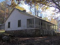
- Calhoun House, built by George Higdon and purchased by Granville Calhoun in 1928 After 1944, park rangers used the Calhoun House as a bunkhouse, giving it the name "Hazel Creek Hilton." The house is located at the Hazel Creek trailhead, near Campsite 86.
- Hall Cabin, built in 1892 by Jesse "Crate" Hall and his wife Tabitha Dills Hall, located at the end of the Bone Valley Trail. This cabin, made of poplar logs, is the most remote historical structure in the Great Smokies, being a 9 miles (14.5 km) hike from the ferry rendezvous. In the 1920s, the cabin was used by the Kress family as part of a hunting lodge. In 1976, the cabin was placed on the National Register of Historic PlacesNational Register of Historic PlacesThe National Register of Historic Places is the United States government's official list of districts, sites, buildings, structures, and objects deemed worthy of preservation...
. This "Hall Cabin" should not be confused with the "Hall Cabin" mentioned often by Kephart, which was a herder's shack atop the crest of the Smokies near Chestnut Bald (although both were built by Crate Hall).
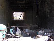
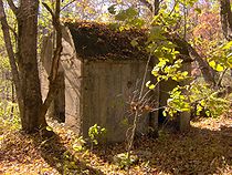
- The Ritter Mill Site consists of the ruins of the R.M. Ritter Lumber Company's saw mill, mill pond (now empty), and drying kilns, built around 1910. An unmarked manway leads from the Hazel Creek Trail to the sawmill site, where the walls of the sawmill still stand. The manway continues uphill to the site of "the Clubhouse," which was a lodge used by Ritter executives and dignitaries. The mill is located about 0.5 miles (804.7 m) east of the Calhoun House.
- The Adams-Westfeldt Mine Site, located along Little Fork of Sugar Fork, about two miles (3 km) above Campsite 84 (Medlin). Author Horace Kephart lived in a cabin at the mining site from 1904-1907.
- Proctor Cemetery, located on a hill about 0.5 miles (804.7 m) east of the Calhoun House in Possum Hollow. The cemetery is also the site of the cabin (no longer standing) of Moses and Patience Proctor, who were the first Euro-American settlers in the area in 1829.
- Bone Valley Cemetery, located on a hill northwest of the junction of the Bone Valley Trail and Hazel Creek Trail. Several members of the Hall, Laney, and Cook families are buried here. The Bone Valley Baptist Church, built by Joshua Calhoun around 1880, was also located at the trail junction.
External links
- Great Smoky Mountains National Park — official site
- Fontana Village Marina — provides ferry access to the Hazel Creek Trail
- The North Shore Road Environmental Impact State Website — information regarding the North Shore Road Project
- Horace Kephart: Revealing an Enigma — writer who lived in the Hazel Creek area 1904-1907