
Gregory Bald
Encyclopedia
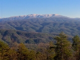
Gregory Bald is a mountain on the western fringe of the Great Smoky Mountains
. It has an elevation of 4,949 feet (1,508 meters) above sea level. The mountain's majestic summit makes it a popular hiking destination.
Gregory Bald is located along the Tennessee-North Carolina border, between Blount County
and Swain County. It rises appx. 3,000 feet above its northern base in Cades Cove
, and appx. 3,300 feet above its southern base at Fontana Lake. The mountain is located entirely within the Great Smoky Mountains National Park
.
Gregory Bald is a type of mountain known as a grassy bald
. Unlike most summits in the Appalachians, which are heavily-forested or culminate in jagged peaks, grassy balds are covered by a thick layer of wild grass. Trees and other foliage are sparse. How and why a summit develops into a grassy bald is unknown. While there is evidence that Gregory Bald was a natural grassy bald, the National Park Service
must currently work to prevent the summit from becoming forested.
rock known as Elkmont sandstone. In a few places atop the mountain, sandstone ruts actually erupt through the thick grass. The Elkmont sandstone is part of the Ocoee Supergroup, which was formed from ancient ocean sediments between 500 million and one billion years ago. Gregory Bald, along with most mountains in the area, was formed appx. 200 million years ago during the Appalachian orogeny.
 The Cherokee
name for Gregory Bald was "Tsistu'yi," or "Rabbit Place." According to tribal lore, the chief of all rabbits— known simply as the Great Rabbit— lived at the summit. The rabbit, considered by the Cherokee to be sly and mischievous, was a key figure in tribal legends, showing the importance the tribe placed upon the mountain.
The mountain was listed by Arnold Guyot in his 1856 survey of the Smokies, although Guyot gave it the name "Great Bald's Central Peak", and measured its elevation at 4,922 feet. The name "Gregory Bald" was given to the mountain by Cades Cove
residents in honor of Russell Gregory (1795–1864), a prominent Cades Cove settler from Ireland. He and two other settlers made a deal to each take 1/3 of the land to live upon. Gregory used the mountain to graze cattle during the spring and summer, when the fields in the cove were needed for growing crops. He lived atop the mountain during this part of the year in a circular stone house near the mountain's summit (the house is no longer standing). Gregory, who (like most Cades Covers) supported the Union
during the American Civil War
, was murdered by a Confederate
soldier in 1863 while trying to protect his cattle and land. His grave bears the legend "Murdered by North Carolina rebels".
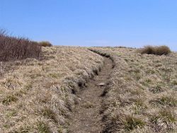 The summit of Gregory Bald can be reached via several well-maintained hiking trails. From Cades Cove
, the summit can be reached via the Gregory Ridge Trail (5.5 miles). This trail begins at the end of Forge Creek Road, which is a gravel road on the Cades Cove Loop just past the Cable Mill area. From Fontana, the summit is reached via the Appalachian Trail
and a two-mile connector trail (7.3 miles). From Twentymile, the summit is reached via the Wolf Ridge Trail (7.3 miles).
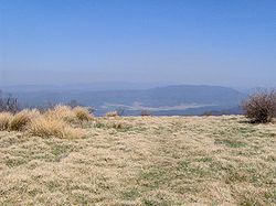
From the summit, one can see Cades Cove and Rich Mountain to the north, and the Nantahala
and Yellow Creek Mountains to the south. Visible to the east is the crest of the Smokies, including Thunderhead Mountain
and Clingman's Dome. Fontana Lake and Shuckstack
are discernible to the southeast.
Great Smoky Mountains
The Great Smoky Mountains are a mountain range rising along the Tennessee–North Carolina border in the southeastern United States. They are a subrange of the Appalachian Mountains, and form part of the Blue Ridge Physiographic Province. The range is sometimes called the Smoky Mountains or the...
. It has an elevation of 4,949 feet (1,508 meters) above sea level. The mountain's majestic summit makes it a popular hiking destination.
Gregory Bald is located along the Tennessee-North Carolina border, between Blount County
Blount County, Tennessee
Blount County is a U.S. county located in the U.S. state of Tennessee. Its population was 123,010 at the United States Census, 2010. The county seat is at Maryville, which is also the county's largest city....
and Swain County. It rises appx. 3,000 feet above its northern base in Cades Cove
Cades Cove
Cades Cove is an isolated valley located in the Tennessee section of Great Smoky Mountains National Park, USA. The valley was home to numerous settlers before the formation of the national park...
, and appx. 3,300 feet above its southern base at Fontana Lake. The mountain is located entirely within the Great Smoky Mountains National Park
Great Smoky Mountains National Park
Great Smoky Mountains National Park is a United States National Park and UNESCO World Heritage Site that straddles the ridgeline of the Great Smoky Mountains, part of the Blue Ridge Mountains, which are a division of the larger Appalachian Mountain chain. The border between Tennessee and North...
.
Gregory Bald is a type of mountain known as a grassy bald
Appalachian balds
In the Appalachian Mountains of the eastern United States, balds are mountain summits or crests covered primarily by thick vegetation of native grasses or shrubs occurring in areas where heavy forest growth would be expected....
. Unlike most summits in the Appalachians, which are heavily-forested or culminate in jagged peaks, grassy balds are covered by a thick layer of wild grass. Trees and other foliage are sparse. How and why a summit develops into a grassy bald is unknown. While there is evidence that Gregory Bald was a natural grassy bald, the National Park Service
National Park Service
The National Park Service is the U.S. federal agency that manages all national parks, many national monuments, and other conservation and historical properties with various title designations...
must currently work to prevent the summit from becoming forested.
Geology
Gregory Bald is composed of a precambrianPrecambrian
The Precambrian is the name which describes the large span of time in Earth's history before the current Phanerozoic Eon, and is a Supereon divided into several eons of the geologic time scale...
rock known as Elkmont sandstone. In a few places atop the mountain, sandstone ruts actually erupt through the thick grass. The Elkmont sandstone is part of the Ocoee Supergroup, which was formed from ancient ocean sediments between 500 million and one billion years ago. Gregory Bald, along with most mountains in the area, was formed appx. 200 million years ago during the Appalachian orogeny.
History
Cherokee
The Cherokee are a Native American people historically settled in the Southeastern United States . Linguistically, they are part of the Iroquoian language family...
name for Gregory Bald was "Tsistu'yi," or "Rabbit Place." According to tribal lore, the chief of all rabbits— known simply as the Great Rabbit— lived at the summit. The rabbit, considered by the Cherokee to be sly and mischievous, was a key figure in tribal legends, showing the importance the tribe placed upon the mountain.
The mountain was listed by Arnold Guyot in his 1856 survey of the Smokies, although Guyot gave it the name "Great Bald's Central Peak", and measured its elevation at 4,922 feet. The name "Gregory Bald" was given to the mountain by Cades Cove
Cades Cove
Cades Cove is an isolated valley located in the Tennessee section of Great Smoky Mountains National Park, USA. The valley was home to numerous settlers before the formation of the national park...
residents in honor of Russell Gregory (1795–1864), a prominent Cades Cove settler from Ireland. He and two other settlers made a deal to each take 1/3 of the land to live upon. Gregory used the mountain to graze cattle during the spring and summer, when the fields in the cove were needed for growing crops. He lived atop the mountain during this part of the year in a circular stone house near the mountain's summit (the house is no longer standing). Gregory, who (like most Cades Covers) supported the Union
Union (American Civil War)
During the American Civil War, the Union was a name used to refer to the federal government of the United States, which was supported by the twenty free states and five border slave states. It was opposed by 11 southern slave states that had declared a secession to join together to form the...
during the American Civil War
American Civil War
The American Civil War was a civil war fought in the United States of America. In response to the election of Abraham Lincoln as President of the United States, 11 southern slave states declared their secession from the United States and formed the Confederate States of America ; the other 25...
, was murdered by a Confederate
Confederate States of America
The Confederate States of America was a government set up from 1861 to 1865 by 11 Southern slave states of the United States of America that had declared their secession from the U.S...
soldier in 1863 while trying to protect his cattle and land. His grave bears the legend "Murdered by North Carolina rebels".
Access
Cades Cove
Cades Cove is an isolated valley located in the Tennessee section of Great Smoky Mountains National Park, USA. The valley was home to numerous settlers before the formation of the national park...
, the summit can be reached via the Gregory Ridge Trail (5.5 miles). This trail begins at the end of Forge Creek Road, which is a gravel road on the Cades Cove Loop just past the Cable Mill area. From Fontana, the summit is reached via the Appalachian Trail
Appalachian Trail
The Appalachian National Scenic Trail, generally known as the Appalachian Trail or simply the AT, is a marked hiking trail in the eastern United States extending between Springer Mountain in Georgia and Mount Katahdin in Maine. It is approximately long...
and a two-mile connector trail (7.3 miles). From Twentymile, the summit is reached via the Wolf Ridge Trail (7.3 miles).
From the summit, one can see Cades Cove and Rich Mountain to the north, and the Nantahala
Nantahala National Forest
The Nantahala National Forest, established in 1920, is a national forest located in the American state of North Carolina. The word "Nantahala" is a Cherokee word meaning "Land of the Noonday Sun." The name is appropriate as, in some spots, the sun only reaches the floors of the deep gorges of the...
and Yellow Creek Mountains to the south. Visible to the east is the crest of the Smokies, including Thunderhead Mountain
Thunderhead Mountain
Thunderhead Mountain is a mountain in the west-central part of the Great Smoky Mountains, located in the Southeastern United States. Rising along the border between Tennessee and North Carolina, the mountain dominates the Western Smokies. The Appalachian Trail crosses its summit, making it a...
and Clingman's Dome. Fontana Lake and Shuckstack
Shuckstack
Shuckstack is a mountain in the Great Smoky Mountains, located in the Southeastern United States. It has an elevation of above sea level, and rises approximately above Fontana Lake, to the south....
are discernible to the southeast.
External links
- Great Smoky Mountains National Park Trail Map - Large file in .pdf format.
- Gregory Bald Hybrid Azaleas - A collection of photos and information on this flower that grows famously on Gregory Bald during the summer.
- Great Smoky Mountains National Park Trail Reviews - A brief review of hiking to Gregory Bald via the Gregory Ridge Trail.
- NPS History of Grassy Balds in Smokies
- Gregory Ridge Trail Hiking information