
Thunderhead Mountain
Encyclopedia
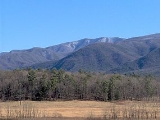
Thunderhead Mountain is a mountain in the west-central part of the Great Smoky Mountains
, located in the Southeastern United States
. Rising along the border between Tennessee
and North Carolina
, the mountain dominates the Western Smokies. The Appalachian Trail
crosses its summit, making it a popular hiking destination. Rocky Top, a knob on the western part of the mountain's summit ridge, shares its name with a popular Tennessee state song
.
Thunderhead rises approximately 3500 feet (1,066.8 m) above its northern base at Little River and approximately 3000 feet (914.4 m) above its southern base at Bone Valley. The mountain consists of three peaks, the lowest being Rocky Top at 5440 feet (1,658.1 m) above sea level and the easternmost being the highest at 5527 feet (1,684.6 m) above sea level. Thunderhead is the highest point in Blount County
,http://www.cs.utk.edu/~dunigan/cohp/ Tennessee and the highest point on the Appalachian Trail coming from the south until the trail ascends Silers Bald
(5,607 ft) some 10 miles (16.1 km) to the east.
The mountain's name originated in the 19th century. It probably referred to the unpredictable weather that often strikes the higher elevations in the Smokies. According to Laura Thornborough, a writer who hiked to the summit of Thunderhead along with local guide Sam Cook in the 1930s:
sandstone. Thunderhead sandstone is part of the Ocoee Supergroup, which was formed from ancient ocean sediments between 500 million and one billion years ago. The mountain itself was formed appx. 200 million years ago during the Appalachian orogeny, when the collision of the North American and African plates thrust the rock upward.
 James Spence, who cleared the ridge two miles (3 km) to the west (now known as Spence Field
), was the first known permanent settler in the vicinity. While the extent of Spence's farm is unknown, cattle-grazing had rendered Thunderhead a grassy bald
by the late-19th century.
 Thunderhead is one of the few mountains listed under its current name in Arnold Guyot's 1859 survey of the crest of the Smokies. Guyot measured Thunderhead's elevation at 5520 feet (1,682.5 m) above sea level, missing the modern measurement by just seven feet.
During the Civil War, a group of East Tennesseans attempted to form a wilderness settlement on the mountain's north slope known as "New World," although the settlement didn't last. The settlement was located along Thunderhead Prong, near Chimney Rocks.
As preservationist groups began buying land in the Smokies in the early 1900s, Thunderhead became a favorite hiking destination for park visitors. John W. Oliver, the great-grandson of the first European settlers in Cades Cove
, started offering guided hikes to the
mountain in 1924. The trail he (and Thornborough's guide, Sam Cook) used largely followed the Bote Mountain Trail-Appalachian Trail route still in use today.
In the years after the Great Smoky Mountains National Park
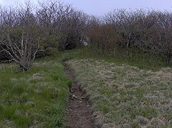
was formed, wooded plants started to reclaim much of the Smokies crest west of Clingmans Dome
. Park strategy at present is to allow Thunderhead to return to its natural state. A narrow path is maintained across the top of the mountain for Appalachian Trail thru-hikers.
 The Bote Mountain Trail, with its trailhead on Little River Road, ascends seven miles (11 km) to the crest of the Smokies and intersects the Appalachian Trail
at Spence Field. From Spence Field, it is approximately two miles to the summit of Thunderhead. The Lead Cove Trail, also beginning on Little River Road (near Cades Cove
), offers the shortest access to the summit by bypassing the first 4 miles (6 km) of the Bote Mountain Trail. From the Lead Cove trailhead, it is approximately 7 miles (11.3 km) to the summit of Thunderhead. The Anthony Creek Trail, rising out of the Cades Cove campground, also bypasses the first 4 miles (6 km) of the Bote Mountain Trail. From the Anthony Creek trailhead, it is approximately 7.5 miles (12.1 km) to the summit of Thunderhead.
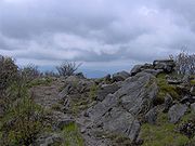
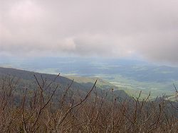
While the main summit of Thunderhead is covered in foliage, Rocky Top offers a 360-degree view of the western Smokies.
Great Smoky Mountains
The Great Smoky Mountains are a mountain range rising along the Tennessee–North Carolina border in the southeastern United States. They are a subrange of the Appalachian Mountains, and form part of the Blue Ridge Physiographic Province. The range is sometimes called the Smoky Mountains or the...
, located in the Southeastern United States
Southeastern United States
The Southeastern United States, colloquially referred to as the Southeast, is the eastern portion of the Southern United States. It is one of the most populous regions in the United States of America....
. Rising along the border between Tennessee
Tennessee
Tennessee is a U.S. state located in the Southeastern United States. It has a population of 6,346,105, making it the nation's 17th-largest state by population, and covers , making it the 36th-largest by total land area...
and North Carolina
North Carolina
North Carolina is a state located in the southeastern United States. The state borders South Carolina and Georgia to the south, Tennessee to the west and Virginia to the north. North Carolina contains 100 counties. Its capital is Raleigh, and its largest city is Charlotte...
, the mountain dominates the Western Smokies. The Appalachian Trail
Appalachian Trail
The Appalachian National Scenic Trail, generally known as the Appalachian Trail or simply the AT, is a marked hiking trail in the eastern United States extending between Springer Mountain in Georgia and Mount Katahdin in Maine. It is approximately long...
crosses its summit, making it a popular hiking destination. Rocky Top, a knob on the western part of the mountain's summit ridge, shares its name with a popular Tennessee state song
Rocky Top
"Rocky Top" is an American country and bluegrass song written by Felice and Boudleaux Bryant in 1967 and first recorded by the Osborne Brothers later that same year...
.
Thunderhead rises approximately 3500 feet (1,066.8 m) above its northern base at Little River and approximately 3000 feet (914.4 m) above its southern base at Bone Valley. The mountain consists of three peaks, the lowest being Rocky Top at 5440 feet (1,658.1 m) above sea level and the easternmost being the highest at 5527 feet (1,684.6 m) above sea level. Thunderhead is the highest point in Blount County
Blount County, Tennessee
Blount County is a U.S. county located in the U.S. state of Tennessee. Its population was 123,010 at the United States Census, 2010. The county seat is at Maryville, which is also the county's largest city....
,http://www.cs.utk.edu/~dunigan/cohp/ Tennessee and the highest point on the Appalachian Trail coming from the south until the trail ascends Silers Bald
Silers Bald
Silers Bald is a mountain in the western Great Smoky Mountains, located in theSoutheastern United States. Its proximity to Clingmans Dome and its location alongthe Appalachian Trail make it a popular hiking destination....
(5,607 ft) some 10 miles (16.1 km) to the east.
The mountain's name originated in the 19th century. It probably referred to the unpredictable weather that often strikes the higher elevations in the Smokies. According to Laura Thornborough, a writer who hiked to the summit of Thunderhead along with local guide Sam Cook in the 1930s:
"As we proceeded in a near-gale to Rocky Top, the first of the three major peaks of Thunderhead, Sam remarked, "It'll be thunderin' and lightnin' on Thunderhead when it's clear on every other peak on top o' Smoky, and that's how hit got its name."
Geology
Thunderhead consists of precambrianPrecambrian
The Precambrian is the name which describes the large span of time in Earth's history before the current Phanerozoic Eon, and is a Supereon divided into several eons of the geologic time scale...
sandstone. Thunderhead sandstone is part of the Ocoee Supergroup, which was formed from ancient ocean sediments between 500 million and one billion years ago. The mountain itself was formed appx. 200 million years ago during the Appalachian orogeny, when the collision of the North American and African plates thrust the rock upward.
History
Spence Field
Spence Field is a highland meadow in the Great Smoky Mountains, located inthe Southeastern United States. It has an elevation of 4,920 feet above sea level...
), was the first known permanent settler in the vicinity. While the extent of Spence's farm is unknown, cattle-grazing had rendered Thunderhead a grassy bald
Appalachian balds
In the Appalachian Mountains of the eastern United States, balds are mountain summits or crests covered primarily by thick vegetation of native grasses or shrubs occurring in areas where heavy forest growth would be expected....
by the late-19th century.
During the Civil War, a group of East Tennesseans attempted to form a wilderness settlement on the mountain's north slope known as "New World," although the settlement didn't last. The settlement was located along Thunderhead Prong, near Chimney Rocks.
As preservationist groups began buying land in the Smokies in the early 1900s, Thunderhead became a favorite hiking destination for park visitors. John W. Oliver, the great-grandson of the first European settlers in Cades Cove
Cades Cove
Cades Cove is an isolated valley located in the Tennessee section of Great Smoky Mountains National Park, USA. The valley was home to numerous settlers before the formation of the national park...
, started offering guided hikes to the
mountain in 1924. The trail he (and Thornborough's guide, Sam Cook) used largely followed the Bote Mountain Trail-Appalachian Trail route still in use today.
In the years after the Great Smoky Mountains National Park
Great Smoky Mountains National Park
Great Smoky Mountains National Park is a United States National Park and UNESCO World Heritage Site that straddles the ridgeline of the Great Smoky Mountains, part of the Blue Ridge Mountains, which are a division of the larger Appalachian Mountain chain. The border between Tennessee and North...
was formed, wooded plants started to reclaim much of the Smokies crest west of Clingmans Dome
Clingmans Dome
Clingmans Dome is a mountain in the Great Smoky Mountains of Tennessee and North Carolina, in the southeastern United States. At an elevation of , it is the highest mountain in the Smokies, the highest point in the state of Tennessee, and the highest point along the Appalachian Trail...
. Park strategy at present is to allow Thunderhead to return to its natural state. A narrow path is maintained across the top of the mountain for Appalachian Trail thru-hikers.
Access
Appalachian Trail
The Appalachian National Scenic Trail, generally known as the Appalachian Trail or simply the AT, is a marked hiking trail in the eastern United States extending between Springer Mountain in Georgia and Mount Katahdin in Maine. It is approximately long...
at Spence Field. From Spence Field, it is approximately two miles to the summit of Thunderhead. The Lead Cove Trail, also beginning on Little River Road (near Cades Cove
Cades Cove
Cades Cove is an isolated valley located in the Tennessee section of Great Smoky Mountains National Park, USA. The valley was home to numerous settlers before the formation of the national park...
), offers the shortest access to the summit by bypassing the first 4 miles (6 km) of the Bote Mountain Trail. From the Lead Cove trailhead, it is approximately 7 miles (11.3 km) to the summit of Thunderhead. The Anthony Creek Trail, rising out of the Cades Cove campground, also bypasses the first 4 miles (6 km) of the Bote Mountain Trail. From the Anthony Creek trailhead, it is approximately 7.5 miles (12.1 km) to the summit of Thunderhead.
While the main summit of Thunderhead is covered in foliage, Rocky Top offers a 360-degree view of the western Smokies.
External links
- Great Smoky Mountains National Park Trail Map - Large file in .pdf format.
- Thunderhead Mountain - SummitPost.org
- Thunderhead Mountain - Peakbagger.com
- Hiking information for Rocky Top and Thunderhead
- GSMNP landforms