

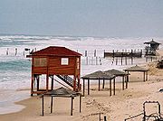
Gush Katif
Encyclopedia
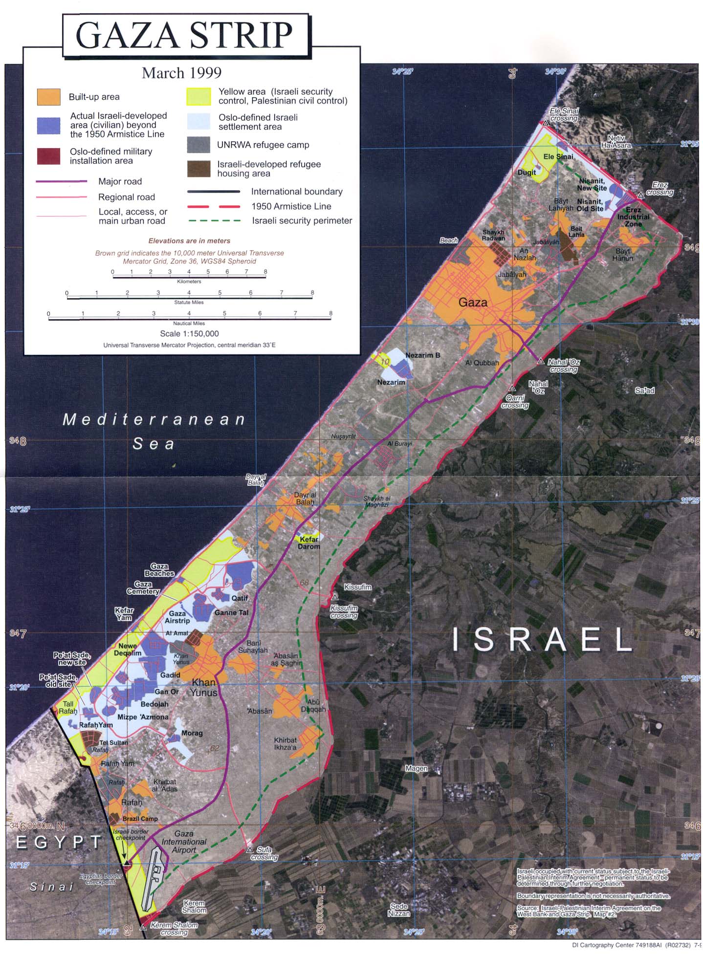
Gaza Strip
thumb|Gaza city skylineThe Gaza Strip lies on the Eastern coast of the Mediterranean Sea. The Strip borders Egypt on the southwest and Israel on the south, east and north. It is about long, and between 6 and 12 kilometres wide, with a total area of...
. Gush Katif was specifically mentioned by Yitzhak Rabin
Yitzhak Rabin
' was an Israeli politician, statesman and general. He was the fifth Prime Minister of Israel, serving two terms in office, 1974–77 and 1992 until his assassination in 1995....
, the Israeli prime minister who fell victim to an assassin in 1995, as essential to Israel's security border. In August 2005, the Israeli army moved the 8,600 residents of Gush Katif to Israel. They were evicted from the area and their homes demolished as part of Israel's unilateral disengagement plan
Israel's unilateral disengagement plan
Israel's unilateral disengagement plan , also known as the "Disengagement plan", "Gaza expulsion plan", and "Hitnatkut", was a proposal by Israeli Prime Minister Ariel Sharon, adopted by the government on June 6, 2004 and enacted in August 2005, to evict all Israelis from the Gaza Strip and from...
from the Gaza Strip portion of the Palestinian Territories.
Geography
Gush Katif was located on the southwestern edge of the Gaza Strip, bordered on the southwest by RafahRafah
Rafah , also known as Rafiah, is a Palestinian city in the southern Gaza Strip. Located south of Gaza, Rafah's population of 71,003 is overwhelmingly made up of Palestinian refugees. Rafah camp and Tall as-Sultan form separate localities. Rafah is the district capital of the Rafah Governorate...
and the Egyptian border, on the east by Khan Yunis
Khan Yunis
Khan Yunis - often spelt Khan Younis or Khan Yunnis - is a city and adjacent refugee camp in the southern part of the Gaza Strip. According to the Palestinian Central Bureau of Statistics the city, its refugee camp, and its immediate surroundings had a total population of 180,000 in 2006...
, on the northeast by Deir el-Balah
Deir el-Balah
Deir el-Balah or Dayr al-Balah is located in the central Gaza Strip and is the capital or muhfaza of the Deir el-Balah Governorate...
, and on the west and northwest by the Mediterranean Sea
Mediterranean Sea
The Mediterranean Sea is a sea connected to the Atlantic Ocean surrounded by the Mediterranean region and almost completely enclosed by land: on the north by Anatolia and Europe, on the south by North Africa, and on the east by the Levant...
. A narrow one kilometer strip of land populated by Bedouin
Bedouin
The Bedouin are a part of a predominantly desert-dwelling Arab ethnic group traditionally divided into tribes or clans, known in Arabic as ..-Etymology:...
Palestinians known as al-Mawasi
Al-Mawasi
Al-Mawasi is a Bedouin Palestinian town on the southern coast of the Gaza Strip, approximately one kilometer wide and fourteen kilometers long, that prior to Israel's unilateral disengagement plan in 2005 existed as a Palestinian enclave within the Katif bloc of Israeli settlements...
lay along the Mediterranean coast. Most of Gush Katif was situated on the sand dunes that separate the coastal plain
Coastal plain
A coastal plain is an area of flat, low-lying land adjacent to a seacoast and separated from the interior by other features. One of the world's longest coastal plains is located in eastern South America. The southwestern coastal plain of North America is notable for its species diversity...
from the sea along much of the southeastern Mediterranean.
Two roads served the residents of Gush Katif: Road 230, which runs from the southwest along the sea from the Egyptian border at Rafiah Yam
Rafiah Yam
Rafiah Yam was an Israeli settlement, originally established in 1984 as a secular community in the southern end of the Gush Katif settlement bloc, only 200 metres from the Egyptian border and close to the Palestinian city of Rafah....
through Kfar Yam
Kfar Yam
Kfar Yam was a small outpost and one of the Gaza Strip Israeli Settlements abandoned in Israel's 2005 disengagement plan. It was a non-religious community established in 1983, and had a population of 10 ....
to Tel Katifa
Tel Katifa
Tel Katifa , was a small Israeli settlement located in the northeast end of the Gush Katif settlement bloc of the Gaza Strip, and evacuated in Israel's disengagement of 2005. The settlement was named after the adjacent archeological site from the Canaanite period. The Palestinian village of Deir...
on the bloc's northern border, where it entered Palestinian-controlled territory, and Road 240, which also runs parallel to the sea approximately one kilometre inland, and upon which the majority of the settlements and traffic were located. Road 240's southern end turned south to reach Morag
Morag
Morag may refer to:* Morag , a lake monster reported to inhabit Loch Morar in Scotland* Morąg , a city in Warmia-Masuria, Poland...
and continued to Sufah and the Shalom bloc of villages south of the Gaza Strip, while its northern end turned east to the Kissufim
Kissufim
Kissufim is a kibbutz in the northwestern Negev desert in Israel. Located adjacent to the Gaza Strip, it falls under the jurisdiction of Eshkol Regional Council. It sits at an altitude of 92 metres above sea level.- History :...
junction, and served as the main route into Gush Katif. These roads were forbidden to Palestinian Arab drivers.
While Kfar Darom
Kfar Darom
Kfar Darom was a kibbutz and an Israeli settlement within the Gush Katif bloc in the Gaza Strip.-Original kibbutz:Kfar Darom was founded on 250 dunams of land purchased in 1930 by Tuvia Miller for a fruit orchard on the site of an ancient Jewish settlement of the same name mentioned in the Talmud...
and Netzarim
Netzarim (settlement)
Netzarim was formerly an Israeli settlement established in Gaza in 1972. It began as a secular Nahal outpost of the Hashomer Hatzair movement; in 1984 it became an orthodox kibbutz. A few years later, the residents decided to change from a kibbutz to a village...
were originally accessed along the main road to Gaza
Gaza
Gaza , also referred to as Gaza City, is a Palestinian city in the Gaza Strip, with a population of about 450,000, making it the largest city in the Palestinian territories.Inhabited since at least the 15th century BC,...
(known as "Tencher Road"), Israeli and Palestinian traffic was separated after the Oslo Accords
Oslo Accords
The Oslo Accords, officially called the Declaration of Principles on Interim Self-Government Arrangements or Declaration of Principles , was an attempt to resolve the ongoing Palestinian-Israeli conflict...
, and Netzarim was isolated as an enclave accessed only through the Karni crossing
Karni crossing
The Karni Crossing is a cargo terminal on the Israel-Gaza Strip barrier. It is located in the north-eastern end of the Gaza Strip and was opened in 1994 after the signing of the Oslo Accords, in order to allow Palestinian merchants to export and import goods...
and the Sa'ad junction. In 2002, a bridge was built for Road 240 over the Tencher road so as to physically separate the two arteries and allow unobstructed travel for both Palestinian and Israeli traffic.
Demographics
Orthodox Judaism
Orthodox Judaism , is the approach to Judaism which adheres to the traditional interpretation and application of the laws and ethics of the Torah as legislated in the Talmudic texts by the Sanhedrin and subsequently developed and applied by the later authorities known as the Gaonim, Rishonim, and...
Religious Zionist
Religious Zionism
Religious Zionism is an ideology that combines Zionism and Jewish religious faith...
Jews, though many non-observant and secular Jew
Secular Jewish culture
Secular Jewish culture embraces several related phenomena; above all, it is the international culture of secular communities of Jewish people, but it can also include the cultural contributions of individuals who identify as secular Jews...
s also called it home. The area also included several hundred Muslim families, mostly of the al-Mawasi
Al-Mawasi
Al-Mawasi is a Bedouin Palestinian town on the southern coast of the Gaza Strip, approximately one kilometer wide and fourteen kilometers long, that prior to Israel's unilateral disengagement plan in 2005 existed as a Palestinian enclave within the Katif bloc of Israeli settlements...
Bedouin
Bedouin
The Bedouin are a part of a predominantly desert-dwelling Arab ethnic group traditionally divided into tribes or clans, known in Arabic as ..-Etymology:...
community, who while technically Palestinian residents, were able to enjoy freedom of movement within the Israeli areas due to their peaceful relations.
History
A historic Jewish community existed in Gaza City prior to its expulsion following deadly riots in 1929 by the city's Arabs. Land for the village of Kfar DaromKfar Darom
Kfar Darom was a kibbutz and an Israeli settlement within the Gush Katif bloc in the Gaza Strip.-Original kibbutz:Kfar Darom was founded on 250 dunams of land purchased in 1930 by Tuvia Miller for a fruit orchard on the site of an ancient Jewish settlement of the same name mentioned in the Talmud...
was purchased in the 1930s and settled in 1946. It was evacuated following an Egyptian siege in the 1948 Arab-Israeli War
1948 Arab-Israeli War
The 1948 Arab–Israeli War, known to Israelis as the War of Independence or War of Liberation The war commenced after the termination of the British Mandate for Palestine and the creation of an independent Israel at midnight on 14 May 1948 when, following a period of civil war, Arab armies invaded...
.
Gush Katif began in earnest in 1968, when Yigal Allon
Yigal Allon
Yigal Allon was an Israeli politician, a commander of the Palmach, and a general in the IDF. He served as one of the leaders of Ahdut HaAvoda party and the Israeli Labor party, and acting Prime Minister of Israel, and was a member of the Knesset and government minister from the 10th through the...
presented an initiative for the founding of two Nahal settlement
Nahal settlement
Nahal settlements were settlements established by Nahal soldiers in Israel and Israeli-occupied territories. Supporting Jewish settlement growth and expansion throughout Israel was once the main focus of the Nahal military brigade. The goal for every Nahal settlement was to become a civilian...
s in the center of the Gaza Strip. He viewed the breaking of the continuity between the northern and southern Arab settlements as vital to Israel's security in the area, which had been captured the previous year in the 1967 Six-Day War
Six-Day War
The Six-Day War , also known as the June War, 1967 Arab-Israeli War, or Third Arab-Israeli War, was fought between June 5 and 10, 1967, by Israel and the neighboring states of Egypt , Jordan, and Syria...
. In 1970, Kfar Darom was reestablished as the first of many Israeli agricultural villages in the area. Allon's idea was ultimately designed with five key areas (or 'fingers,' thus being called by some the "five-finger print") slated for Israeli presence along the length of the Gaza Strip. After the Israel-Egypt Peace Treaty
Israel-Egypt Peace Treaty
The 1979 Egypt–Israel Peace Treaty was signed in Washington, D.C. on the 26th of March 1979, following the 1978 Camp David Accords, which were signed by Egyptian President Anwar El Sadat and Israeli Prime Minister Menachem Begin, and were witnessed by United States President Jimmy Carter.The peace...
and the dismantling of the fifth 'finger' (Yamit
Yamit
Yamit was an Israeli settlement in the northern part of the Sinai Peninsula with a population of about 2,500 people .The settlement was established during Israel's occupation of the peninsula from the end of the 1967 Six-Day War, until that part of the Sinai was handed over to Egypt in 1982 as...
bloc) south of Rafah, the fourth (Morag
Morag
Morag may refer to:* Morag , a lake monster reported to inhabit Loch Morar in Scotland* Morąg , a city in Warmia-Masuria, Poland...
) and third (Kfar Darom) strips were united into one bloc that would become known as Gush Katif. The second finger, Netzarim
Netzarim
Netzarim may refer to:* Netzarim, twigs that shoot off from a branch of a tree * Netzarim , the name of an Israeli settlement in the Gaza Strip...
, was very much connected to Gush Katif until the arrangements following the Oslo Accords
Oslo Accords
The Oslo Accords, officially called the Declaration of Principles on Interim Self-Government Arrangements or Declaration of Principles , was an attempt to resolve the ongoing Palestinian-Israeli conflict...
, while the bloc on the dunes north of Gaza, which straddled the Green Line
Green Line (Israel)
Green Line refers to the demarcation lines set out in the 1949 Armistice Agreements between Israel and its neighbours after the 1948 Arab-Israeli War...
, was more a part of the Ashkelon
Ashkelon
Ashkelon is a coastal city in the South District of Israel on the Mediterranean coast, south of Tel Aviv, and north of the border with the Gaza Strip. The ancient seaport of Ashkelon dates back to the Neolithic Age...
area communities.http://www1.idf.il/dover/site/mainpage.asp?sl=EN&id=22&docid=43198&clr=1&subject=43024&Pos=1&bScope=False
Throughout the 1980s new communities were established, especially with the influx of former residents of the Sinai
Sinai Peninsula
The Sinai Peninsula or Sinai is a triangular peninsula in Egypt about in area. It is situated between the Mediterranean Sea to the north, and the Red Sea to the south, and is the only part of Egyptian territory located in Asia as opposed to Africa, effectively serving as a land bridge between two...
. Most of the bloc's communities were established as agricultural cooperatives called moshav
Moshav
Moshav is a type of Israeli town or settlement, in particular a type of cooperative agricultural community of individual farms pioneered by the Labour Zionists during the second aliyah...
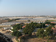
s, where the residents from each town would work in clusters of greenhouses just outside the residential areas.
Economy
Herb
Except in botanical usage, an herb is "any plant with leaves, seeds, or flowers used for flavoring, food, medicine, or perfume" or "a part of such a plant as used in cooking"...
s answering to the strictest health, aesthetic and religious requirements. Most of the organic agricultural product
Organic farming
Organic farming is the form of agriculture that relies on techniques such as crop rotation, green manure, compost and biological pest control to maintain soil productivity and control pests on a farm...
s were exported to Europe. In addition, the community of Atzmona had Israel’s largest plant nursery, and with 800 cows, the Katif
Katif (moshav)
Katif was an Israeli settlement in the Gush Katif bloc in the Gaza Strip, about 1 km north of the Palestinian refugee camp of Deir el-Balah. It was founded in 1977 as an Orthodox moshav. The name is derived from the nearby Tel Katifa archeological site....
dairy was the second largest in the country. Telesales and Printing
Printing
Printing is a process for reproducing text and image, typically with ink on paper using a printing press. It is often carried out as a large-scale industrial process, and is an essential part of publishing and transaction printing....
were other notable industries.
The total sum of exports from the greenhouses of Gush Katif, which were owned by 200 farmers, came to $200,000,000 per year and made up 15% of the agricultural exports of the State of Israel.
The combined assets in Gush Katif were estimated at $23 billion.
Of Israel’s total exports abroad, Gush Katif exported:
- 95% of bug-free lettuce and greens
- 70% of organic vegetables
- 60% of cherry tomatoes
- 60% of geraniums to Europe.
The Economic Cooperation Foundation
Economic Cooperation Foundation
The Economic Cooperation Foundation was founded by Dr. Yair Hirschfeld , former Minister of Justice Dr...
, which is funded by the European Union
European Union
The European Union is an economic and political union of 27 independent member states which are located primarily in Europe. The EU traces its origins from the European Coal and Steel Community and the European Economic Community , formed by six countries in 1958...
, agreed to purchase the greenhouses for $14 million and transfer ownership to the Palestinian Authority
Palestinian National Authority
The Palestinian Authority is the administrative organization established to govern parts of the West Bank and Gaza Strip...
, so that the 4,000 Palestinians employed to work in them could keep their jobs. Former head of the World Bank
World Bank
The World Bank is an international financial institution that provides loans to developing countries for capital programmes.The World Bank's official goal is the reduction of poverty...
, James Wolfensohn
James Wolfensohn
Sir James David Wolfensohn AO KBE FKC was the ninth president of the World Bank Group.-Early life:James Wolfensohn was born in Sydney, Australia, on 1 December 1933...
, contributed $500,000 of his own money to the project.
When the IDF left Gaza, thousands of Palestinians looted the area, and 800 of the 4,000 greenhouses were left unusable.http://www.jewishvirtuallibrary.org/jsource/Peace/hothouses.html
Palestinian attacks
Gaza Division
The Israel Defense Forces Gaza Division , is subordinate to the Southern Regional Command. Its area of operation is the Gaza Strip and the area surrounding it...
, settlers were still vulnerable to attacks.
During the First Intifada
First Intifada
The First Intifada was a Palestinian uprising against the Israeli occupation of the Palestinian Territories. The uprising began in the Jabalia refugee camp and quickly spread throughout Gaza, the West Bank and East Jerusalem....
(1987–1990), which broke out in nearby Gaza, the residents of Gush Katif were on the forefront of the violence and were subject to frequent stoning of traffic, among other incidents.
Since the beginning of the al-Aqsa Intifada
Al-Aqsa Intifada
The Second Intifada, also known as the Al-Aqsa Intifada and the Oslo War, was the second Palestinian uprising, a period of intensified Palestinian-Israeli violence, which began in late September 2000...
(2000), Gush Katif settlements were the target of thousands of violent attacks by Palestinian militants. More than 6000 mortar
Mortar (weapon)
A mortar is an indirect fire weapon that fires explosive projectiles known as bombs at low velocities, short ranges, and high-arcing ballistic trajectories. It is typically muzzle-loading and has a barrel length less than 15 times its caliber....
bombs and Qassam rocket
Qassam rocket
The Qassam rocket is a simple steel artillery rocket developed and deployed by the Izz ad-Din al-Qassam Brigades, the military arm of Hamas. Three models have been produced and used between 2001 and 2011....
s were launched into Gush Katif, causing mostly property and psychological damage with very few fatalities, but heavy shock and fear. Most of the ground attacks were infiltration
Infiltration tactics
In warfare, infiltration tactics involve small, lightly equipped infantry forces attacking enemy rear areas while bypassing enemy front line strongpoints and isolating them for attack by follow-up troops with heavier weapons.-Development during World War I:...
s and shootings. There were also attempts to infiltrate by sea.
Palestinian attacks on Israeli vehicles traveling on the Kissufim road were very common. In one of these attacks, in May 2004, Palestinian militants killed Tali Hatuel
Tali Hatuel
The murder of Tali Hatuel and her four daughters was a shooting attack which occurred on May 2, 2004, in which Palestinian militants killed five members of the Hatuel family in Gush Katif. Tali Hatuel, an Israeli resident who resided in Gush Katif, was eight months pregnant and was murdered along...
, who was eight months pregnant, and her four daughters, aged two to 11. In another, a school bus
School bus
A school bus is a type of bus designed and manufactured for student transport: carrying children and teenagers to and from school and school events...
was bombed, leaving two dead and several maimed children. Many of the ground attacks on Gush Katif were thwarted by the Israeli military.
Controversy
Its location was initially the main reason for its founding, as an Israeli civilian presence was important for cementing control of the area so as to prevent any future invasion from Egypt or its use as a staging area for fedayeen
Fedayeen
Fedayeen is a term used to describe several distinct militant groups and individuals in West Asia at different times in history. It is sometimes used colloquially to refer to suicide squads, especially those who are not bombers.-Overview:...
attacks, and indeed this rationale was echoed following the 1967 Six Day War by the US Joint Chiefs of Staff
Joint Chiefs of Staff
The Joint Chiefs of Staff is a body of senior uniformed leaders in the United States Department of Defense who advise the Secretary of Defense, the Homeland Security Council, the National Security Council and the President on military matters...
.
As Israeli-Palestinian conflict
Israeli-Palestinian conflict
The Israeli–Palestinian conflict is the ongoing conflict between Israelis and Palestinians. The conflict is wide-ranging, and the term is also used in reference to the earlier phases of the same conflict, between Jewish and Zionist yishuv and the Arab population living in Palestine under Ottoman or...
ensued, the security argument included that an Israeli presence prevented heavy bombardment of long-range Katyusha rockets on Israeli towns such as Sderot
Sderot
Sderot is a western Negev city in the Southern District of Israel. According to the Israel Central Bureau of Statistics , at the end of 2009 the city had a total population of 20,700. The city has been an ongoing target of Qassam rocket attacks from the Gaza Strip...
and Ashkelon
Ashkelon
Ashkelon is a coastal city in the South District of Israel on the Mediterranean coast, south of Tel Aviv, and north of the border with the Gaza Strip. The ancient seaport of Ashkelon dates back to the Neolithic Age...
(as indeed happened, after the disengagement), and served as an outpost for intelligence gathering and preemption against suicide bombers and other infiltrators. This arrangement, however, proved to be less and less useful as attacks on Israel proper using rockets and mortars started well before the Israeli withdrawal from the occupied Gaza Strip.
Many advocates of settlement in Gush Katif view it as part of the Land of Israel
Land of Israel
The Land of Israel is the Biblical name for the territory roughly corresponding to the area encompassed by the Southern Levant, also known as Canaan and Palestine, Promised Land and Holy Land. The belief that the area is a God-given homeland of the Jewish people is based on the narrative of the...
and thus subject to a theological injunction for settlement, and some also assert a right of return
Right of return
The term right of return refers to a principle of international law, codified in the Universal Declaration of Human Rights and the International Covenant on Civil and Political Rights, giving any person the right to return to, and re-enter, his or her country of origin...
to Gaza, as Jews had been living there for over 1600 years until they were moved out by the British during the 1929 Palestine riots
1929 Palestine riots
The 1929 Palestine riots, also known as the Western Wall Uprising, the 1929 Massacres, , or the Buraq Uprising , refers to a series of demonstrations and riots in late August 1929 when a long-running dispute between Muslims and Jews over access to the Western Wall in Jerusalem escalated into violence...
.
However critics of Gush Katif pointed to some of the same arguments as reasons to discontinue settlement there. Especially as Palestinian attacks intensified to unprecedented levels during the al-Aqsa Intifada
Al-Aqsa Intifada
The Second Intifada, also known as the Al-Aqsa Intifada and the Oslo War, was the second Palestinian uprising, a period of intensified Palestinian-Israeli violence, which began in late September 2000...
and the Israeli military presence increased proportionally, the bloc was seen by some as being an unnecessary theatre of confrontation that acted as a drain on the IDF's resources, especially in extreme cases such as Netzarim in which during certain periods of intense violence on the roads was only accessible via helicopter. The increasing security measures taken by the IDF including checkpoints
Israel Defense Forces checkpoint
A Israel Defense Forces checkpoint, usually called an Israeli checkpoint , is a barrier erected by the Israel Defense Forces with the stated aim of enhancing the security of Israel and Israeli settlements and preventing those who wish to do harm from crossing...
and severe restrictions on Palestinian travel, as well as the creation of extended buffer zones near settlements were also seen as negatively impacting the Palestinian population's human rights. Other critics pointed to the occupation of part of the Gaza Strip's land by the settlements for a small population, relative to the extremely dense Palestinian population of the Gaza Strip. Despite Gush Katif's having been constructed on barren sand dunes, it was also criticised for blocking access to 1/3 of the Strip's seashore from cities such as Rafah and Khan Yunis. For example, Palestinians were forcibly banned from the beaches near Israeli settlements and forbidden to use Gaza's coastal road in these areas.
Evacuation
On August 13, 2005, the Gush Katif region was closed to non-residents, in keeping with the plan to evacuate the Katif bloc. Though effectively violating the Disengagement law, which most residents viewed as highly immoral and illegitimate, most settlers did not voluntarily leave their homes or even pack in preparation for the eviction. On August 15, 2005, the forcible evacuation of the Gush Katif settlements began. On August 22, 2005, the residents of the last settlement, Netzarim, were evicted. In essence, many residents returned to pack the contents of their homes and the Israeli government began the destruction of all residential buildings. On September 12, 2005, the Israeli Army withdrew from each settlement up to the Green LineGreen Line (Israel)
Green Line refers to the demarcation lines set out in the 1949 Armistice Agreements between Israel and its neighbours after the 1948 Arab-Israeli War...
. All public buildings (schools, libraries, community centres, office buildings) as well as industrial buildings, factories and greenhouses which could not be taken apart were left intact.
Originally, the Israeli cabinet had planned to destroy synagogues in the settlement, but the government caved in to pressure from religious Jewish organizations and reversed its decision.
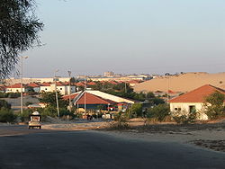
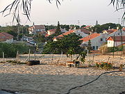
Settlements in Gush Katif
- BedolahBedolahBedolah was an Israeli village, an Israeli settlement and army base in the Gush Katif settlement bloc, located in the southwest edge of the Gaza Strip...
בדולח (lit. Crystal) - Bnei AtzmonBnei AtzmonBnei Atzmon was an Israeli settlement founded in 1979 in the Yamit region of the Sinai peninsula as a response to Camp David Accords, which promoted trading territory for peace...
בני עצמון - GadidGadidGadid was an Israeli settlement located in the middle of the Gush Katif settlement bloc whose residents were expelled in Israel's disengagement of 2005...
גדיד (lit. picking of palm tree fruits) - Gan OrGan OrGan Or was an Israeli settlement located in the Gush Katif settlement bloc and evacuated in Israel's disengagement of 2005. On the day of its evacuation 52 families, over 320 people, lived there....
גן אור (lit. Garden of light) - Ganei TalGanei TalGanei Tal was an Israeli settlement in the south of the Gaza Strip. Located in the Gush Katif settlement bloc, it was established as a moshav in 1979 with a primarily agricultural purpose; exporting geraniums and tomatoes to Europe. It had a population of some 75 families, or 500 people.Lined...
גני טל (lit. Gardens of dew) - Kfar DaromKfar DaromKfar Darom was a kibbutz and an Israeli settlement within the Gush Katif bloc in the Gaza Strip.-Original kibbutz:Kfar Darom was founded on 250 dunams of land purchased in 1930 by Tuvia Miller for a fruit orchard on the site of an ancient Jewish settlement of the same name mentioned in the Talmud...
כפר דרום (lit. South village) - Kfar YamKfar YamKfar Yam was a small outpost and one of the Gaza Strip Israeli Settlements abandoned in Israel's 2005 disengagement plan. It was a non-religious community established in 1983, and had a population of 10 ....
כפר ים (lit. Village of the sea) - Kerem AtzmonaKerem AtzmonaKerem Atzmona was an unauthorized Israeli outpost in the Gush Katif settlement bloc, located in the south-west edge of the Gaza Strip, and evacuated as part of Israel's unilateral disengagement plan of 2005. The village, founded on Tu Bishvat in 2001, was located adjacent to the settlement of Bnei...
כרם עצמונה - MoragMorag, GazaMorag was a moshav and an Israeli settlement in Gush Katif, in the south-west edge of the Gaza Strip, evacuated in Israel's disengagement of 2005....
מורג (lit. Harvest scythe) - Neve DekalimNeve DekalimNeve Dekalim was an Israeli settlement and a community in the Gush Katif settlement bloc in the Gaza Strip. It was founded in 1983 after the Israeli withdrawal from the Sinai Peninsula, on sand dunes that were previously uninhabited. The village served as a regional center for the Gush Katif...
נוה דקלים (lit. Palm tree Oasis) - Netzer HazaniNetzer HazaniNetzer Hazani was an Israeli settlement located in the northeast corner of the Gush Katif and evacuated in Israel's disengagement of 2005...
נצר חזני - Pe'at SadePe'at SadePe'at Sadeh was an Israeli settlement, originally established in 1989 by a group of families on the 'Slav' IDF base in the southern end of Gush Katif and moved to its permanent site on an adjacent hill in 1993...
פאת שדה (lit. the edge of the field) - KatifKatif (moshav)Katif was an Israeli settlement in the Gush Katif bloc in the Gaza Strip, about 1 km north of the Palestinian refugee camp of Deir el-Balah. It was founded in 1977 as an Orthodox moshav. The name is derived from the nearby Tel Katifa archeological site....
קטיף (lit. harvest, picking of flowers) - Rafiah YamRafiah YamRafiah Yam was an Israeli settlement, originally established in 1984 as a secular community in the southern end of the Gush Katif settlement bloc, only 200 metres from the Egyptian border and close to the Palestinian city of Rafah....
רפיח ים - Shirat HayamShirat HayamShirat HaYam was an Israeli settlement established in 2001 on the shores of the Mediterranean Sea west of Neve Dekalim in the Gush Katif settlement bloc....
שירת הים (lit. Song of the sea) - SlavSlav (settlement)Slav was a Jewish village and an Israeli settlement in the Gush Katif settlement bloc, located in the south-west edge of the Gaza Strip, whose residents were evicted in Israel's unilateral disengagement plan of 2005...
שליו (lit. Quail) - Tel KatifaTel KatifaTel Katifa , was a small Israeli settlement located in the northeast end of the Gush Katif settlement bloc of the Gaza Strip, and evacuated in Israel's disengagement of 2005. The settlement was named after the adjacent archeological site from the Canaanite period. The Palestinian village of Deir...
תל קטיפא
The Gush Katif settlements were concentrated in one block on the southwest edge of the Gaza Strip and were surrounded by fencing.
In addition to Gush Katif, there were three Israeli settlements on the northern edge of the Gaza Strip (Elei Sinai
Elei Sinai
Elei Sinai was an Israeli settlement in the north of Gaza Strip. It was established in 1982 by a group who had been evicted from Yamit. It was named for the yearning to return to the Sinai desert, where Yamit was located....
, Dugit
Dugit
Dugit was an Israeli settlement located in the northern tip of the Gaza Strip closest to the shore of the Mediterranean Sea in a mini-settlement bloc including Elei Sinai and Nisanit...
and Nisanit
Nisanit
Nisanit was the largest Israeli settlement in the northern tip of the Gaza Strip in a mini-settlement bloc including Elei Sinai and Dugit. While Nisanit was under the municipal authority of the Hof Aza Regional Council it was not physically in the Gush Katif bloc where the bulk of the 'Gush Katif'...
), and another near its center (Netzarim
Netzarim (settlement)
Netzarim was formerly an Israeli settlement established in Gaza in 1972. It began as a secular Nahal outpost of the Hashomer Hatzair movement; in 1984 it became an orthodox kibbutz. A few years later, the residents decided to change from a kibbutz to a village...
).
See also
- Gaza stripGaza Stripthumb|Gaza city skylineThe Gaza Strip lies on the Eastern coast of the Mediterranean Sea. The Strip borders Egypt on the southwest and Israel on the south, east and north. It is about long, and between 6 and 12 kilometres wide, with a total area of...
- Israeli settlementIsraeli settlementAn Israeli settlement is a Jewish civilian community built on land that was captured by Israel from Jordan, Egypt, and Syria during the 1967 Six-Day War and is considered occupied territory by the international community. Such settlements currently exist in the West Bank...
- Religious ZionismReligious ZionismReligious Zionism is an ideology that combines Zionism and Jewish religious faith...
- Occupied territoriesOccupied territoriesOccupied territory is territory under military occupation. Occupation is a term of art in international law; in accordance with Article 42 of the Laws and Customs of War on Land ; October 18, 1907, territory is considered occupied when it is actually placed under the authority of the hostile army...
- Israeli-occupied territoriesIsraeli-occupied territoriesThe Israeli-occupied territories are the territories which have been designated as occupied territory by the United Nations and other international organizations, governments and others to refer to the territory seized by Israel during the Six-Day War of 1967 from Egypt, Jordan, and Syria...
- Gush Katif after Israeli WithdrawalGush Katif after Israeli WithdrawalGush Katif was an Israeli settlement located in the far south of the Gaza Strip. It was established in the late 1970s and eventually had a population of 8600. The Israeli government unilaterally removed all Gaza settlments, including Gush Katif, in August 2005.-Controversy in Israel:The action...
Further reading
- Map of Gaza Strip, showing settlements
- Gush Katif official website (Hebrew), English version
- Virtual Tour of Gush Katif
- Gaza population figures
- The Gaza Strip Jewish Virtual LibraryJewish Virtual LibraryJewish Virtual Library is an online encyclopedia published by the American-Israeli Cooperative Enterprise . Established in 1993, it is a comprehensive website covering Israel, the Jewish people, and Jewish culture.-History:...
- Photos: Gaza Withdrawal Newsday.com (104 photos)
- Jewish Settlements, Outposts Expanding Despite Pledges Growth Most Striking in Gaza Strip, Report Says, By John Ward Anderson, Washington Post Foreign Service, Friday, July 23, 2004; Page A26