

Geography of Tanzania
Encyclopedia
Tanzania
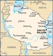
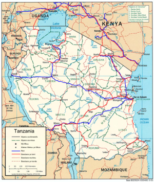
The United Republic of Tanzania is a country in East Africa bordered by Kenya and Uganda to the north, Rwanda, Burundi, and the Democratic Republic of the Congo to the west, and Zambia, Malawi, and Mozambique to the south. The country's eastern borders lie on the Indian Ocean.Tanzania is a state...
geography is one of the most varied and unique in the world; it contains Africa
Africa
Africa is the world's second largest and second most populous continent, after Asia. At about 30.2 million km² including adjacent islands, it covers 6% of the Earth's total surface area and 20.4% of the total land area...
's highest point, Mount Kilimanjaro
Mount Kilimanjaro
Kilimanjaro, with its three volcanic cones, Kibo, Mawenzi, and Shira, is a dormant volcano in Kilimanjaro National Park, Tanzania and the highest mountain in Africa at above sea level .-Geology:...
(5895 m (19,341 ft)), as well as lakes, mountains and many natural parks.
The north-east of Tanzania is mountainous and includes Mount Meru
Mount Meru (Tanzania)
Mount Meru is an active stratovolcano located west of Mount Kilimanjaro in the nation of Tanzania. At a height of , it is visible from Mt Kilimanjaro on a clear day, and is the tenth highest mountain in Africa. Much of its bulk was lost about 8,000 years ago due to an eastward volcanic blast,...
and Mount Kilimanjaro, both of which are active volcanoes. Kilimanjaro's natural beauty, as well as its fame for being the highest peak in Africa, attracts thousands of tourists each year.
West of the mountains is Serengeti National Park
Serengeti National Park
The Serengeti National Park is a large national park in Serengeti area, Tanzania. It is most famous for its annual migration of over one and a half million white bearded wildebeest and 250,000 zebra...
, famous for its annual migration of millions of white bearded wildebeest
Wildebeest
The wildebeest , also called the gnu is an antelope of the genus Connochaetes. It is a hooved mammal...
, as well as its abundance of lion
Lion
The lion is one of the four big cats in the genus Panthera, and a member of the family Felidae. With some males exceeding 250 kg in weight, it is the second-largest living cat after the tiger...
s, leopard
Leopard
The leopard , Panthera pardus, is a member of the Felidae family and the smallest of the four "big cats" in the genus Panthera, the other three being the tiger, lion, and jaguar. The leopard was once distributed across eastern and southern Asia and Africa, from Siberia to South Africa, but its...
s, elephant
Elephant
Elephants are large land mammals in two extant genera of the family Elephantidae: Elephas and Loxodonta, with the third genus Mammuthus extinct...
s, rhinoceros
Rhinoceros
Rhinoceros , also known as rhino, is a group of five extant species of odd-toed ungulates in the family Rhinocerotidae. Two of these species are native to Africa and three to southern Asia....
es, and buffalo. Close to the park lies Olduvai Gorge
Olduvai Gorge
The Olduvai Gorge is a steep-sided ravine in the Great Rift Valley that stretches through eastern Africa. It is in the eastern Serengeti Plains in northern Tanzania and is about long. It is located 45 km from the Laetoli archaeological site...
, where many of the oldest hominid fossils and artifacts have been found. Also in this northern area are a number of salt lake
Salt lake
A salt lake or saline lake is a landlocked body of water which has a concentration of salts and other dissolved minerals significantly higher than most lakes . In some cases, salt lakes have a higher concentration of salt than sea water, but such lakes would also be termed hypersaline lakes...
s including Lake Natron
Lake Natron
Lake Natron is a salt lake located in northern Tanzania, close to the Kenyan border, in the eastern branch of Africa's Great Rift Valley. The lake is fed by the Ewaso Ng'iro River but also by mineral-rich hot springs and is quite shallow, less than three meters deep, and varies in width depending...
an important breeding site for flamingo
Flamingo
Flamingos or flamingoes are gregarious wading birds in the genus Phoenicopterus , the only genus in the family Phoenicopteridae...
es and an ecoregion
Ecoregion
An ecoregion , sometimes called a bioregion, is an ecologically and geographically defined area that is smaller than an ecozone and larger than an ecosystem. Ecoregions cover relatively large areas of land or water, and contain characteristic, geographically distinct assemblages of natural...
in its own right.
Further west is Lake Victoria
Lake Victoria
Lake Victoria is one of the African Great Lakes. The lake was named for Queen Victoria of the United Kingdom, by John Hanning Speke, the first European to discover this lake....
on the Kenya
Kenya
Kenya , officially known as the Republic of Kenya, is a country in East Africa that lies on the equator, with the Indian Ocean to its south-east...
–Uganda
Uganda
Uganda , officially the Republic of Uganda, is a landlocked country in East Africa. Uganda is also known as the "Pearl of Africa". It is bordered on the east by Kenya, on the north by South Sudan, on the west by the Democratic Republic of the Congo, on the southwest by Rwanda, and on the south by...
–Tanzania border. This is the largest lake in Africa and is traditionally named as the source of the Nile. Southwest of this, separating Tanzania from the Democratic Republic of the Congo
Democratic Republic of the Congo
The Democratic Republic of the Congo is a state located in Central Africa. It is the second largest country in Africa by area and the eleventh largest in the world...
, is Lake Tanganyika
Lake Tanganyika
Lake Tanganyika is an African Great Lake. It is estimated to be the second largest freshwater lake in the world by volume, and the second deepest, after Lake Baikal in Siberia; it is also the world's longest freshwater lake...
. This lake is estimated to be the second oldest (and second deepest) lake in the world after Lake Baikal
Lake Baikal
Lake Baikal is the world's oldest at 30 million years old and deepest lake with an average depth of 744.4 metres.Located in the south of the Russian region of Siberia, between Irkutsk Oblast to the northwest and the Buryat Republic to the southeast, it is the most voluminous freshwater lake in the...
in Siberia
Siberia
Siberia is an extensive region constituting almost all of Northern Asia. Comprising the central and eastern portion of the Russian Federation, it was part of the Soviet Union from its beginning, as its predecessor states, the Tsardom of Russia and the Russian Empire, conquered it during the 16th...
. The western portion of the country between Lakes Victoria, Tanganyika and Malawi consists of flat land that has been categorised by the World Wildlife Fund as part of the Central Zambezian Miombo woodlands
Central Zambezian Miombo woodlands
The densely forested Central Zambezian Miombo woodlands that cut across southern central Africa are one of the largest ecozones on the continent and home to a great variety of wildlife including many large mammals.-Location and description:...
ecoregion
Ecoregion
An ecoregion , sometimes called a bioregion, is an ecologically and geographically defined area that is smaller than an ecozone and larger than an ecosystem. Ecoregions cover relatively large areas of land or water, and contain characteristic, geographically distinct assemblages of natural...
. Other archaeologically important finds include the oldest evidence of hominids' use of wood at the Kalambo Falls
Kalambo Falls
Kalambo Falls on the Kalambo River is a 772ft single drop waterfall on the border of Zambia and Tanzania at the southeast end of Lake Tanganyika. The falls are some of the tallest uninterrupted falls in Africa...
, further south on the border with Zambia
Zambia
Zambia , officially the Republic of Zambia, is a landlocked country in Southern Africa. The neighbouring countries are the Democratic Republic of the Congo to the north, Tanzania to the north-east, Malawi to the east, Mozambique, Zimbabwe, Botswana and Namibia to the south, and Angola to the west....
.
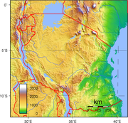
The centre of Tanzania is a large plateau
Plateau
In geology and earth science, a plateau , also called a high plain or tableland, is an area of highland, usually consisting of relatively flat terrain. A highly eroded plateau is called a dissected plateau...
. The southern half of this plain is grassland within the Eastern Miombo woodlands
Eastern Miombo woodlands
The Eastern Miombo woodlands are an ecoregion of grassland and woodland in southern Tanzania and northern Mozambique.-Setting:These species-rich savanna ecosystems cover wide areas of gentle hills and low valleys containing rivers and dambo wetlands...
ecoregion, the majority of which is covered by the huge Selous National Park. Further north the plateau is arable land and the new capital, Dodoma
Dodoma
Dodoma , officially Dodoma Urban District, population 324,347 , is the national capital of Tanzania, and the capital of the Dodoma region. In 1973, plans were made to move the capital to Dodoma...
, is located here, although much of the government is still located in Dar es Salaam
Dar es Salaam
Dar es Salaam , formerly Mzizima, is the largest city in Tanzania. It is also the country's richest city and a regionally important economic centre. Dar es Salaam is actually an administrative province within Tanzania, and consists of three local government areas or administrative districts: ...
.
The eastern coast of Tanzania is hot and humid, and contains Tanzania's largest city and former capital, Dar es Salaam. Just north of Dar es Salaam lies the island of Zanzibar
Unguja
Unguja as mentioned in The Periplus of the Erythraean Sea is the largest and most populated island of Zanzibar, in Tanzania.-Geography:...
, a semi-autonomous territory of Tanzania which is famous for its spices. Its lesser-known sibling Pemba lies further to the north. The coast is home to areas of East African mangroves
East African mangroves
The East African mangroves are an ecoregion consisting of mangrove swamps along the Indian Ocean coast of East Africa in southern Mozambique, Tanzania, Kenya and southern Somalia.-Location and description:...
, mangrove
Mangrove
Mangroves are various kinds of trees up to medium height and shrubs that grow in saline coastal sediment habitats in the tropics and subtropics – mainly between latitudes N and S...
swamps that are an important habitat for wildlife on land and in the water.
The climate of Tanzania ranges from hot and humid on the coast, to a more temperate climate in the elevated centre of the country. Tanzania has two rainy seasons; a long heavy one from March to May, and a shorter, lighter one from November to January.
Tanzania is divided into 25 regions
Regions of Tanzania
Tanzania is divided into 26 regions.-See also:* list of Tanzanian regions by area ranks the regions by their total area, land area, and water area.* Districts of Tanzania* ISO 3166-2:TZ-External links:*...
; twenty on the mainland, three on Zanzibar island and two on Pemba.
Climate
Tanzania has a tropical climate. In the highlands, temperatures range between 10 and 20 °C (50 and 68 F) during cold and hot seasons respectively. The rest of the country has temperatures rarely falling lower than 20 °C (68 °F). The hottest period extends between November and February (25–31 °C (77–87.8 F)) while the coldest period occurs between May and August (15–20 °C (59–68 F)).Tanzania has two major rainfall regions. One is unimodal (December - April) and the other is bimodal (October -December and March - May). The former is experienced in southern, south-west, central and western parts of the country, and the latter is found to the north and northern coast.
In the bimodal regime the March - May rains are referred to as the long rains or Masika, whereas the October - December rains are generally known as short rains or Vuli.
Fact file
East Africa
East Africa or Eastern Africa is the easterly region of the African continent, variably defined by geography or geopolitics. In the UN scheme of geographic regions, 19 territories constitute Eastern Africa:...
, bordering the Indian Ocean
Indian Ocean
The Indian Ocean is the third largest of the world's oceanic divisions, covering approximately 20% of the water on the Earth's surface. It is bounded on the north by the Indian Subcontinent and Arabian Peninsula ; on the west by eastern Africa; on the east by Indochina, the Sunda Islands, and...
, between Kenya
Kenya
Kenya , officially known as the Republic of Kenya, is a country in East Africa that lies on the equator, with the Indian Ocean to its south-east...
and Mozambique
Mozambique
Mozambique, officially the Republic of Mozambique , is a country in southeastern Africa bordered by the Indian Ocean to the east, Tanzania to the north, Malawi and Zambia to the northwest, Zimbabwe to the west and Swaziland and South Africa to the southwest...
.
Geographic coordinates: 6°00′S 35°00′E
Map references: Africa
Area:
note: includes the islands of Mafia
Mafia Island
Mafia Island is part of the Tanzanian Spice Islands, together with Unguja and Pemba. As one of the six districts of the Pwani Region, Mafia Island is governed from the mainland, not from the semi-autonomous region of Zanzibar, of which it has never been considered to be a part.According to the...
, Pemba and Zanzibar
Unguja
Unguja as mentioned in The Periplus of the Erythraean Sea is the largest and most populated island of Zanzibar, in Tanzania.-Geography:...
- total: 945,087 km²
- land: 886,037 km²
- water: 59,050 km²
Land boundaries:
- total: 3,402 km
- border countries: BurundiBurundiBurundi , officially the Republic of Burundi , is a landlocked country in the Great Lakes region of Eastern Africa bordered by Rwanda to the north, Tanzania to the east and south, and the Democratic Republic of the Congo to the west. Its capital is Bujumbura...
451 km, Kenya 769 km, MalawiMalawiThe Republic of Malawi is a landlocked country in southeast Africa that was formerly known as Nyasaland. It is bordered by Zambia to the northwest, Tanzania to the northeast, and Mozambique on the east, south and west. The country is separated from Tanzania and Mozambique by Lake Malawi. Its size...
475 km, Mozambique 756 km, RwandaRwandaRwanda or , officially the Republic of Rwanda , is a country in central and eastern Africa with a population of approximately 11.4 million . Rwanda is located a few degrees south of the Equator, and is bordered by Uganda, Tanzania, Burundi and the Democratic Republic of the Congo...
217 km, UgandaUgandaUganda , officially the Republic of Uganda, is a landlocked country in East Africa. Uganda is also known as the "Pearl of Africa". It is bordered on the east by Kenya, on the north by South Sudan, on the west by the Democratic Republic of the Congo, on the southwest by Rwanda, and on the south by...
396 km, ZambiaZambiaZambia , officially the Republic of Zambia, is a landlocked country in Southern Africa. The neighbouring countries are the Democratic Republic of the Congo to the north, Tanzania to the north-east, Malawi to the east, Mozambique, Zimbabwe, Botswana and Namibia to the south, and Angola to the west....
338 km, Dem. Rep. of the CongoDemocratic Republic of the CongoThe Democratic Republic of the Congo is a state located in Central Africa. It is the second largest country in Africa by area and the eleventh largest in the world...
473 km
Coastline: 1,424 km
Maritime claims:
- exclusive economic zone: 200 nmi (370.4 km; 230.2 mi)
- territorial sea: 12 nmi (22.2 km; 13.8 mi)
Terrain: plains along coast; central plateau; highlands in north, south
Elevation extremes:
- lowest point: Indian Ocean 0 m
- highest point: Mount KilimanjaroMount KilimanjaroKilimanjaro, with its three volcanic cones, Kibo, Mawenzi, and Shira, is a dormant volcano in Kilimanjaro National Park, Tanzania and the highest mountain in Africa at above sea level .-Geology:...
5,892 m
Natural resources:
hydropower
Hydropower
Hydropower, hydraulic power, hydrokinetic power or water power is power that is derived from the force or energy of falling water, which may be harnessed for useful purposes. Since ancient times, hydropower has been used for irrigation and the operation of various mechanical devices, such as...
, tin
Tin
Tin is a chemical element with the symbol Sn and atomic number 50. It is a main group metal in group 14 of the periodic table. Tin shows chemical similarity to both neighboring group 14 elements, germanium and lead and has two possible oxidation states, +2 and the slightly more stable +4...
, phosphates, iron ore, coal
Coal
Coal is a combustible black or brownish-black sedimentary rock usually occurring in rock strata in layers or veins called coal beds or coal seams. The harder forms, such as anthracite coal, can be regarded as metamorphic rock because of later exposure to elevated temperature and pressure...
, diamond
Diamond
In mineralogy, diamond is an allotrope of carbon, where the carbon atoms are arranged in a variation of the face-centered cubic crystal structure called a diamond lattice. Diamond is less stable than graphite, but the conversion rate from diamond to graphite is negligible at ambient conditions...
s, gemstone
Gemstone
A gemstone or gem is a piece of mineral, which, in cut and polished form, is used to make jewelry or other adornments...
s, gold
Gold
Gold is a chemical element with the symbol Au and an atomic number of 79. Gold is a dense, soft, shiny, malleable and ductile metal. Pure gold has a bright yellow color and luster traditionally considered attractive, which it maintains without oxidizing in air or water. Chemically, gold is a...
, natural gas
Natural gas
Natural gas is a naturally occurring gas mixture consisting primarily of methane, typically with 0–20% higher hydrocarbons . It is found associated with other hydrocarbon fuel, in coal beds, as methane clathrates, and is an important fuel source and a major feedstock for fertilizers.Most natural...
, nickel
Nickel
Nickel is a chemical element with the chemical symbol Ni and atomic number 28. It is a silvery-white lustrous metal with a slight golden tinge. Nickel belongs to the transition metals and is hard and ductile...
Land use:
- arable land: 3%
- permanent crops: 1%
- permanent pastures: 40%
- forests and woodland: 38%
- other: 18% (1993 est.)
Irrigated land: 1,550 km² (1998 est.)
Natural hazards:
the tsetse fly
Tsetse fly
Tsetse , sometimes spelled tzetze and also known as tik-tik flies, are large biting flies that inhabit much of mid-continental Africa between the Sahara and the Kalahari deserts. They live by feeding on the blood of vertebrate animals and are the primary biological vectors of trypanosomes, which...
; flooding on the central plateau during the rainy season; drought
Environment - current issues:
soil degradation; deforestation; desertification; destruction of coral reef
Coral reef
Coral reefs are underwater structures made from calcium carbonate secreted by corals. Coral reefs are colonies of tiny living animals found in marine waters that contain few nutrients. Most coral reefs are built from stony corals, which in turn consist of polyps that cluster in groups. The polyps...
threatens marine habitats; recent droughts affected marginal agriculture
Environment - international agreements:
- party to: BiodiversityBiodiversityBiodiversity is the degree of variation of life forms within a given ecosystem, biome, or an entire planet. Biodiversity is a measure of the health of ecosystems. Biodiversity is in part a function of climate. In terrestrial habitats, tropical regions are typically rich whereas polar regions...
, Climate ChangeUnited Nations Framework Convention on Climate ChangeThe United Nations Framework Convention on Climate Change is an international environmental treaty produced at the United Nations Conference on Environment and Development , informally known as the Earth Summit, held in Rio de Janeiro from June 3 to 14, 1992...
, DesertificationDesertificationDesertification is the degradation of land in drylands. Caused by a variety of factors, such as climate change and human activities, desertification is one of the most significant global environmental problems.-Definitions:...
, Endangered SpeciesEndangered speciesAn endangered species is a population of organisms which is at risk of becoming extinct because it is either few in numbers, or threatened by changing environmental or predation parameters...
, Hazardous Wastes, Law of the SeaLaw of the seaLaw of the sea may refer to:* United Nations Convention on the Law of the Sea* Admiralty law* The Custom of the Sea...
, Nuclear Test Ban, Ozone Layer Protection, Wetlands - signed, but not ratified: Nuclear Test Ban
Geography - note: Kilimanjaro is highest point in Africa.
Specific geographic regions
- Menai Bay Conservation AreaMenai Bay Conservation AreaThe Menai Bay Conservation Area is located in Menai Bay, Zanzibar Tanzania. At , it is Zanzibar's largest marine protected area. It was officially established as a conservation area in August 1997 in the traditional fishing area, known as Unguja Island, covering the tropical marine environment...
- Mount KilimanjaroMount KilimanjaroKilimanjaro, with its three volcanic cones, Kibo, Mawenzi, and Shira, is a dormant volcano in Kilimanjaro National Park, Tanzania and the highest mountain in Africa at above sea level .-Geology:...
- Mount MeruMount Meru (Tanzania)Mount Meru is an active stratovolcano located west of Mount Kilimanjaro in the nation of Tanzania. At a height of , it is visible from Mt Kilimanjaro on a clear day, and is the tenth highest mountain in Africa. Much of its bulk was lost about 8,000 years ago due to an eastward volcanic blast,...
- Olduvai GorgeOlduvai GorgeThe Olduvai Gorge is a steep-sided ravine in the Great Rift Valley that stretches through eastern Africa. It is in the eastern Serengeti Plains in northern Tanzania and is about long. It is located 45 km from the Laetoli archaeological site...
- Umba ValleyUmba ValleyUmba Valley is a geographic area in Tanzania and the world's only source of Umba sapphires.The Umba River flows through the Umba Valley.Specifically, Umba Valley is located in the north of Usambara Mountains in the Tanga Region of Tanzania.-References:...
Extreme points
This is a list of the extreme points of TanzaniaTanzania
The United Republic of Tanzania is a country in East Africa bordered by Kenya and Uganda to the north, Rwanda, Burundi, and the Democratic Republic of the Congo to the west, and Zambia, Malawi, and Mozambique to the south. The country's eastern borders lie on the Indian Ocean.Tanzania is a state...
, the points that are farther north, south, east or west than any other location.
- Northern-most point - unnamed point on the border with UgandaUgandaUganda , officially the Republic of Uganda, is a landlocked country in East Africa. Uganda is also known as the "Pearl of Africa". It is bordered on the east by Kenya, on the north by South Sudan, on the west by the Democratic Republic of the Congo, on the southwest by Rwanda, and on the south by...
in the Kagera riverKagera RiverThe Kagera River, also Akagera River, is an East African river, forming part of the upper headwaters of the Nile and carrying water from its most distant source....
immediately east of the Ugandan town of KikagatiKikagati-Location:Kikagati is located in Isingiro District, Ankole sub-region, in southwestern Uganda. The town lies close to Uganda's border with Tanzania. It is located approximately , by road, southwest of Kampala, Uganda's capital and largest city. This location is approximately , by road, south of...
, Kagera RegionKagera RegionKagera Region is located in the northwestern corner of Tanzania. Bukoba, Kagera Region's capital, is a fast growing town situated on the shore of Lake Victoria. Bukoba lies only 1 degree south of the Equator and is Tanzania's second largest port on the lake. The region neighbors Uganda, Rwanda and... - Eastern-most point - Mnazi, Mtwara RegionMtwara RegionMtwara is a southern region of Tanzania which has been underdeveloped for a long time: development is constrained by the lack of highway and energy infrastructures. The Dar es Salaam-Kibiti-Lindi-Mtwara road has been improved by the completion of the Mkapa bridge over the Rufiji River...
- Eastern-most point (mainland) - unnamed headland immediately east of the town of Mwambo, Mtwara RegionMtwara RegionMtwara is a southern region of Tanzania which has been underdeveloped for a long time: development is constrained by the lack of highway and energy infrastructures. The Dar es Salaam-Kibiti-Lindi-Mtwara road has been improved by the completion of the Mkapa bridge over the Rufiji River...
- Southern-most point - unnamed location on the border with MozambiqueMozambiqueMozambique, officially the Republic of Mozambique , is a country in southeastern Africa bordered by the Indian Ocean to the east, Tanzania to the north, Malawi and Zambia to the northwest, Zimbabwe to the west and Swaziland and South Africa to the southwest...
in the Ravuma river, Ruvuma RegionRuvuma RegionRuvuma is a region in Tanzania. It is named after the Ruvuma River which forms most of its southern boundary with Mozambique. It is also bordered to the North by the Morogoro Region, to the Northeast by the Lindi Region, to the East by the Mtwara Region and to the Northwest by the Iringa Region. ... - Western-most point - unnamed headland immediately west of UjijiUjijiUjiji is the oldest town in western Tanzania, located about 6 miles south of Kigoma. In 1900, the population was estimated at 10,000 and in 1967 about 4,100. Part of the Kigoma/Ujiji urban area, the regional population was about 50,000 in 1978....
, Kigoma RegionKigoma RegionKigoma is one of Tanzania's 26 administrative regions. The regional capital is Kigoma. It is bordered to the North by the Kagera Region, to the East by the Shinyanga and Tabora Regions, to the South by the Rukwa Region, to the West by Lake Tanganyika which forms a border with the Democratic...