

Geography of South Australia
Encyclopedia
The geography of South Australia incorporates the south central part of the continent of Australia
. It is one of the six states of Australia
. South Australia
is bordered on the west by Western Australia
, to the north by the Northern Territory
, Queensland
to the northeast, and both New South Wales
and Victoria
to the east. South Australia's south coast is flanked by the Great Australian Bight
and the Indian Ocean
, although it is referred to locally as the Southern Ocean.
The northern and western parts of the state are extremely arid, in central Australia
, dominated by Lake Eyre
and Lake Torrens
, mostly dry salt lakes. This arid area is sparsely populated, with many large cattle station
s, and significant areas protected
as national parks, or as Aboriginal lands. The only significant roads through these areas are the Stuart Highway
north from Port Augusta
to the Northern Territory, the Eyre Highway
across the Nullarbor Plain
to Western Australia, and the Barrier Highway
east to Broken Hill
in New South Wales. These highways have corresponding railways: the Trans-Australian Railway
going west and east, and the Central Australia Railway going north.
The coastline includes cliffs against the Great Australian Bight
and the western side of Eyre Peninsula
. The coast is less rugged on Spencer Gulf
and Gulf St Vincent (separated by Yorke Peninsula
), Fleurieu Peninsula
, Encounter Bay
and The Coorong.
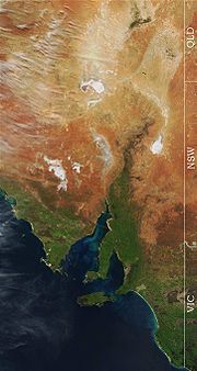 The highest point in the state is Mount Woodroffe
at 1,435 metres (4,708 ft) in the Musgrave Ranges
in the northwest corner of the state. The main range is the Mount Lofty Ranges
and Flinders Ranges
extending approximately 800 kilometres (497 mi) from Fleurieu Peninsula
along the eastern side of Gulf St Vincent and Spencer Gulf
. About half the state is less than 150 m above sea level.
The arid north is delineated from the more fertile southeast by Goyder's Line
, first surveyed in the 1860s, and which has proven to be a remarkably accurate northern boundary marking where sustainable agriculture can be carried out. Three deserts are contained within South Australia's borders: Great Victoria Desert
, Strzelecki Desert
and Sturt Stony Desert.
East of the Mount Lofty Ranges, the Murray River
flows west from New South Wales and Victoria, then south adjacent to the ranges. The Murray River is the only large, permanent river in the state.
on 2 January 1960. This is also the highest official temperature recorded in the whole of Australia. The lowest minimum temperature recorded in South Australia was -8.2°C (17.2°F), at Yongala
on 20 July 1976.
Australia
Australia , officially the Commonwealth of Australia, is a country in the Southern Hemisphere comprising the mainland of the Australian continent, the island of Tasmania, and numerous smaller islands in the Indian and Pacific Oceans. It is the world's sixth-largest country by total area...
. It is one of the six states of Australia
States and territories of Australia
The Commonwealth of Australia is a union of six states and various territories. The Australian mainland is made up of five states and three territories, with the sixth state of Tasmania being made up of islands. In addition there are six island territories, known as external territories, and a...
. South Australia
South Australia
South Australia is a state of Australia in the southern central part of the country. It covers some of the most arid parts of the continent; with a total land area of , it is the fourth largest of Australia's six states and two territories.South Australia shares borders with all of the mainland...
is bordered on the west by Western Australia
Western Australia
Western Australia is a state of Australia, occupying the entire western third of the Australian continent. It is bounded by the Indian Ocean to the north and west, the Great Australian Bight and Indian Ocean to the south, the Northern Territory to the north-east and South Australia to the south-east...
, to the north by the Northern Territory
Northern Territory
The Northern Territory is a federal territory of Australia, occupying much of the centre of the mainland continent, as well as the central northern regions...
, Queensland
Queensland
Queensland is a state of Australia, occupying the north-eastern section of the mainland continent. It is bordered by the Northern Territory, South Australia and New South Wales to the west, south-west and south respectively. To the east, Queensland is bordered by the Coral Sea and Pacific Ocean...
to the northeast, and both New South Wales
New South Wales
New South Wales is a state of :Australia, located in the east of the country. It is bordered by Queensland, Victoria and South Australia to the north, south and west respectively. To the east, the state is bordered by the Tasman Sea, which forms part of the Pacific Ocean. New South Wales...
and Victoria
Victoria (Australia)
Victoria is the second most populous state in Australia. Geographically the smallest mainland state, Victoria is bordered by New South Wales, South Australia, and Tasmania on Boundary Islet to the north, west and south respectively....
to the east. South Australia's south coast is flanked by the Great Australian Bight
Great Australian Bight
The Great Australian Bight is a large bight, or open bay, off the central and western portions of the southern coastline of mainland Australia.-Extent:...
and the Indian Ocean
Indian Ocean
The Indian Ocean is the third largest of the world's oceanic divisions, covering approximately 20% of the water on the Earth's surface. It is bounded on the north by the Indian Subcontinent and Arabian Peninsula ; on the west by eastern Africa; on the east by Indochina, the Sunda Islands, and...
, although it is referred to locally as the Southern Ocean.
The northern and western parts of the state are extremely arid, in central Australia
Central Australia
Central Australia/Alice Springs Region is one of the five regions in the Northern Territory. The term Central Australia is used to describe an area centred on Alice Springs in Australia. It is sometimes referred to as Centralia; likewise the people of the area are sometimes called Centralians...
, dominated by Lake Eyre
Lake Eyre
Lake Eyre is the lowest point in Australia, at approximately below sea level, and, on the rare occasions that it fills, it is the largest lake in Australia and 18th largest in the world...
and Lake Torrens
Lake Torrens
Lake Torrens is a salt lake in central South Australia. It is located in the Lake Torrens National Park....
, mostly dry salt lakes. This arid area is sparsely populated, with many large cattle station
Cattle station
Cattle station is an Australian term for a large farm , whose main activity is the rearing of cattle. In Australia, the owner of a cattle station is called a grazier...
s, and significant areas protected
Protected areas of South Australia
South Australia contains 324 separate Protected Areas with a total land area of 216,310 km² . Eighteen of these areas are National parks, totalling 43,374 km² .-Conservation Parks:...
as national parks, or as Aboriginal lands. The only significant roads through these areas are the Stuart Highway
Stuart Highway
The Stuart Highway is one of Australia's major highways. It is a segment of Australia's Highway 1 extending from Darwin, Northern Territory, in the north, via Tennant Creek and Alice Springs, to Port Augusta, South Australia, in the south—a distance of...
north from Port Augusta
Port Augusta, South Australia
-Electricity generation:Electricity is generated at the Playford B and Northern power stations from brown coal mined at Leigh Creek, 250 km to the north...
to the Northern Territory, the Eyre Highway
Eyre Highway
The Eyre Highway is a highway linking Western Australia and South Australia via the Nullarbor Plain. Signed as National Highway 1/A1, it forms part of Highway 1 and the Australian National Highway network linking Perth and Adelaide. It was named after explorer Edward John Eyre, who was the first to...
across the Nullarbor Plain
Nullarbor Plain
The Nullarbor Plain is part of the area of flat, almost treeless, arid or semi-arid country of southern Australia, located on the Great Australian Bight coast with the Great Victoria Desert to its north. It is the world's largest single piece of limestone, and occupies an area of about...
to Western Australia, and the Barrier Highway
Barrier Highway
The Barrier Highway is a highway in New South Wales and South Australia signposted as in South Australia and in New South Wales, Australia.The Barrier Highway starts at Nyngan where it joins the Mitchell Highway. It heads west past Hermidale and Boppy Mountain to Cobar, a mining town. It then...
east to Broken Hill
Broken Hill, New South Wales
-Geology:Broken Hill's massive orebody, which formed about 1,800 million years ago, has proved to be among the world's largest silver-lead-zinc mineral deposits. The orebody is shaped like a boomerang plunging into the earth at its ends and outcropping in the centre. The protruding tip of the...
in New South Wales. These highways have corresponding railways: the Trans-Australian Railway
Trans-Australian Railway
The Trans-Australian Railway crosses the Nullarbor Plain of Australia from Port Augusta in South Australia to Kalgoorlie in Western Australia...
going west and east, and the Central Australia Railway going north.
The coastline includes cliffs against the Great Australian Bight
Great Australian Bight
The Great Australian Bight is a large bight, or open bay, off the central and western portions of the southern coastline of mainland Australia.-Extent:...
and the western side of Eyre Peninsula
Eyre Peninsula
Eyre Peninsula is a triangular peninsula in South Australia. It is bounded on the east by Spencer Gulf, the west by the Great Australian Bight, and the north by the Gawler Ranges. It is named after explorer Edward John Eyre who explored some of it in 1839-1841. The coastline was first explored by...
. The coast is less rugged on Spencer Gulf
Spencer Gulf
The Spencer Gulf is the westernmost of two large inlets on the southern coast of Australia, in the state of South Australia, facing the Great Australian Bight. The Gulf is 322 km long and 129 km wide at its mouth. The western shore of the Gulf is the Eyre Peninsula, while the eastern side is the...
and Gulf St Vincent (separated by Yorke Peninsula
Yorke Peninsula
The Yorke Peninsula is a peninsula located north-west and west of Adelaide in South Australia, Australia, between Spencer Gulf on the west and Gulf St Vincent on the east. It has geographic coordinates of...
), Fleurieu Peninsula
Fleurieu Peninsula
The Fleurieu Peninsula is a peninsula located south of Adelaide in South Australia, Australia. It was named after the French explorer and hydrographer Charles Pierre Claret de Fleurieu by the French explorer Nicolas Baudin as he mapped the south coast of Australia in 1802.Towns of interest in the...
, Encounter Bay
Encounter Bay
Encounter Bay is located on the south central coast of South Australia, some 100 km south of Adelaide, South Australia. It is named after the encounter on 8 April 1802 between Matthew Flinders and Nicolas Baudin, both of whom were charting the Australian coastline for their respective countries...
and The Coorong.
Mount Woodroffe
Mount Woodroffe is South Australia's highest peak, at 1,435 metres.- Cultural Significance :The mountain is known to the Pitjantjatjara Indigenous Australians as Ngarutjaranya....
at 1,435 metres (4,708 ft) in the Musgrave Ranges
Musgrave Ranges
Musgrave Ranges is a mountain range in Central Australia, straddling the boundary of South Australia and the Northern Territory , extending into Western Australia. It is between the Great Victoria Desert to the south and the Gibson Desert to the north...
in the northwest corner of the state. The main range is the Mount Lofty Ranges
Mount Lofty Ranges
The Mount Lofty Ranges are the range of mountains just to the east of Adelaide in South Australia.-Location and description:The Mount Lofty Ranges stretch from the southernmost point of the Fleurieu Peninsula at Cape Jervis northwards for over before petering out north of Peterborough...
and Flinders Ranges
Flinders Ranges
Flinders Ranges is the largest mountain range in South Australia, which starts approximately north west of Adelaide. The discontinuous ranges stretch for over from Port Pirie to Lake Callabonna...
extending approximately 800 kilometres (497 mi) from Fleurieu Peninsula
Fleurieu Peninsula
The Fleurieu Peninsula is a peninsula located south of Adelaide in South Australia, Australia. It was named after the French explorer and hydrographer Charles Pierre Claret de Fleurieu by the French explorer Nicolas Baudin as he mapped the south coast of Australia in 1802.Towns of interest in the...
along the eastern side of Gulf St Vincent and Spencer Gulf
Spencer Gulf
The Spencer Gulf is the westernmost of two large inlets on the southern coast of Australia, in the state of South Australia, facing the Great Australian Bight. The Gulf is 322 km long and 129 km wide at its mouth. The western shore of the Gulf is the Eyre Peninsula, while the eastern side is the...
. About half the state is less than 150 m above sea level.
The arid north is delineated from the more fertile southeast by Goyder's Line
Goyder's Line
Goyder's Line is a boundary line across South Australia corresponding to a rainfall boundary believed to indicate the edge of the area suitable for agriculture. North of Goyder's Line, the rainfall is not reliable enough, and the land is only suitable for grazing and not cropping. The line traces a...
, first surveyed in the 1860s, and which has proven to be a remarkably accurate northern boundary marking where sustainable agriculture can be carried out. Three deserts are contained within South Australia's borders: Great Victoria Desert
Great Victoria Desert
The Great Victoria Desert is a barren and sparsely populated desert area of southern Australia.-Location and description:The Great Victoria is the biggest desert in Australia and consists of many small sandhills, grassland plains, areas with a closely packed surface of pebbles and salt lakes...
, Strzelecki Desert
Strzelecki Desert
The Strzelecki Desert is located in the Far North Region of South Australia, southwest Queensland and western New South Wales. It is positioned in the northeast of the Lake Eyre Basin, and north of the Flinders Ranges. Two other deserts occupy the Lake Eyre Basin—the Tirari Desert and the...
and Sturt Stony Desert.
East of the Mount Lofty Ranges, the Murray River
Murray River
The Murray River is Australia's longest river. At in length, the Murray rises in the Australian Alps, draining the western side of Australia's highest mountains and, for most of its length, meanders across Australia's inland plains, forming the border between New South Wales and Victoria as it...
flows west from New South Wales and Victoria, then south adjacent to the ranges. The Murray River is the only large, permanent river in the state.
Climate
The state's mean temperature range is 29 °C in January and 15 °C in July. Daily temperatures in parts of the state in January & February can be as high as 48 °C. The highest maximum temperature in that state 50.7 °C (123.3 °F), was recorded at OodnadattaOodnadatta, South Australia
Oodnadatta, South Australia, is a small town surrounded by an area of with cattle stations in arid pastoral rangelands close to the Simpson Desert, north of Adelaide and 112 m above sea level. It can be reached by an unsealed road from Coober Pedy or via the unsealed Oodnadatta Track from...
on 2 January 1960. This is also the highest official temperature recorded in the whole of Australia. The lowest minimum temperature recorded in South Australia was -8.2°C (17.2°F), at Yongala
Yongala, South Australia
Yongala is a small town located in the state of South Australia, Australia. It has a population of approximately 80 people and is situated on the Clare-Peterborough Road . The town was proclaimed on 23 May 1876 and within 5 years had a population of 353 as developers anticipated the connection of...
on 20 July 1976.