

Eyre Highway
Encyclopedia
The Eyre Highway is a highway linking Western Australia
and South Australia
via the Nullarbor Plain
. Signed as National Highway 1/A1, it forms part of Highway 1
and the Australian National Highway
network linking Perth
and Adelaide
. It was named after explorer Edward John Eyre
, who was the first to cross the Nullarbor by land.
The Eyre Highway starts at Norseman
and ends in Port Augusta
. The road, and Highway 1, then continues as Port Wakefield Road
to Adelaide
.
.
Construction on the Eyre Highway first started in July 1941 and was completed six months later. First known as the Forrest Highway (named after John Forrest
) Originally, the roads that followed closely to the route were very rough in condition, and during the road around Australia road trials in the 1950s, movie newsreels would show cars on very sandy tracks. The current route of the highway has not been deviated from significantly during various upgrades to the highway.
The differences between the condition of the road on either side of Eucla were notable as late as the mid-1980s. The last section was finally sealed on the South Australian section only in 1976.
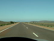
 The Western Australian section of the Eyre Highway lies entirely on the Nullarbor Plain
. The Nullarbor gets its name from Latin for 'no trees'. The typical view is that of a straight highway and practically unchanging flat saltbush covered terrain, although some parts are located on ridges. The population on this stretch was estimated at 86 as at the 2006 census and, apart from Eucla
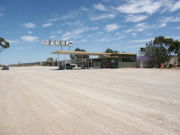
, no towns exist along the route. Roadhouse
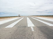
s providing basic services such as petrol, food and bottled water are approximately 200 km (124 mi) to 300 km (186 mi) apart, but not all are open 24 hours. Because of its remoteness, some sections of the Highway serve as emergency airstrips for the Royal Flying Doctor Service. These airstrips are signposted and have runway "piano keys" painted on the road, and turnaround bays for small aircraft.
This section of the highway includes what is regarded as the longest straight stretch of road in the world, between Balladonia and Caiguna; the road stretches for 146.6 kilometres (91.1 mi) without turning.
Localities in this section include:
 The South Australian section of the Eyre Highway crosses the eastern section of the Nullarbor Plain
before arriving in the town of Ceduna
. It then skirts the northern boundary of the Eyre Peninsula
before reaching the city of Port Augusta
. An alternative route between Ceduna and Port Augusta, formerly signed Alternate Route 1 and now signed B100, follows Flinders Highway
and Lincoln Highway
down the western and eastern sides of the peninsula respectively.
Localities in this section include:
Western Australia
Western Australia is a state of Australia, occupying the entire western third of the Australian continent. It is bounded by the Indian Ocean to the north and west, the Great Australian Bight and Indian Ocean to the south, the Northern Territory to the north-east and South Australia to the south-east...
and South Australia
South Australia
South Australia is a state of Australia in the southern central part of the country. It covers some of the most arid parts of the continent; with a total land area of , it is the fourth largest of Australia's six states and two territories.South Australia shares borders with all of the mainland...
via the Nullarbor Plain
Nullarbor Plain
The Nullarbor Plain is part of the area of flat, almost treeless, arid or semi-arid country of southern Australia, located on the Great Australian Bight coast with the Great Victoria Desert to its north. It is the world's largest single piece of limestone, and occupies an area of about...
. Signed as National Highway 1/A1, it forms part of Highway 1
Highway 1 (Australia)
Australia's Highway 1 is a network of highways that circumnavigate the Australian continent, joining all mainland state capitals. At a total length of approximately it is the longest national highway in the world, longer than the Trans-Siberian Highway and the Trans-Canada Highway...
and the Australian National Highway
National Highway (Australia)
thumb|right|150px|The National Highway Shield in NSW, QLD, WA, NT & TAS.The National Highway is a system of roads connecting all the States and Territories of Australia, and is the major network of highways connecting Australia's largest and most important cities.The National Highway was...
network linking Perth
Perth, Western Australia
Perth is the capital and largest city of the Australian state of Western Australia and the fourth most populous city in Australia. The Perth metropolitan area has an estimated population of almost 1,700,000....
and Adelaide
Adelaide
Adelaide is the capital city of South Australia and the fifth-largest city in Australia. Adelaide has an estimated population of more than 1.2 million...
. It was named after explorer Edward John Eyre
Edward John Eyre
Edward John Eyre was an English land explorer of the Australian continent, colonial administrator, and a controversial Governor of Jamaica....
, who was the first to cross the Nullarbor by land.
The Eyre Highway starts at Norseman
Norseman, Western Australia
Norseman is a town located in the Goldfields-Esperance region of Western Australia along the Coolgardie-Esperance Highway, east of Perth and above sea level. It is also the starting point of the Eyre Highway, and the last major town in Western Australia before the South Australian border to the...
and ends in Port Augusta
Port Augusta, South Australia
-Electricity generation:Electricity is generated at the Playford B and Northern power stations from brown coal mined at Leigh Creek, 250 km to the north...
. The road, and Highway 1, then continues as Port Wakefield Road
Port Wakefield Road
Port Wakefield Road is an important Australian highway. It connects Adelaide, the South Australian capital, to the Yorke Peninsula, Port Augusta, northern and western South Australia, the Northern Territory and Western Australia. It is designated National Highway A1 and a part of the National Highway...
to Adelaide
Adelaide
Adelaide is the capital city of South Australia and the fifth-largest city in Australia. Adelaide has an estimated population of more than 1.2 million...
.
History
There are two parts of the Nullarbor crossing that are now distinct and separate routes to the current Eyre Highway: on the Western Australian side is a mapped Old Coach Road that is further north towards the Trans Australia Railway line. On the South Australian side the older highway route runs from Border Village to the Nullarbor Roadhouse, well away from the coast and running through the centre of the Nullarbor National ParkNullarbor National Park
Nullarbor National Park is a national park located in South Australia , 887 km west of Adelaide.The northern boundary is with the Nullarbor Regional Reserve, its western end is at the Western Australia-South Australia state border - with Border Village as the main locality at that boundary...
.
Construction on the Eyre Highway first started in July 1941 and was completed six months later. First known as the Forrest Highway (named after John Forrest
John Forrest
Sir John Forrest GCMG was an Australian explorer, the first Premier of Western Australia and a cabinet minister in Australia's first federal parliament....
) Originally, the roads that followed closely to the route were very rough in condition, and during the road around Australia road trials in the 1950s, movie newsreels would show cars on very sandy tracks. The current route of the highway has not been deviated from significantly during various upgrades to the highway.
The differences between the condition of the road on either side of Eucla were notable as late as the mid-1980s. The last section was finally sealed on the South Australian section only in 1976.
Western Australian section
Nullarbor Plain
The Nullarbor Plain is part of the area of flat, almost treeless, arid or semi-arid country of southern Australia, located on the Great Australian Bight coast with the Great Victoria Desert to its north. It is the world's largest single piece of limestone, and occupies an area of about...
. The Nullarbor gets its name from Latin for 'no trees'. The typical view is that of a straight highway and practically unchanging flat saltbush covered terrain, although some parts are located on ridges. The population on this stretch was estimated at 86 as at the 2006 census and, apart from Eucla
Eucla, Western Australia
Eucla is the easternmost locality in Western Australia, located in the Goldfields-Esperance region of Western Australia along the Eyre Highway, approximately west of the South Australian border...
, no towns exist along the route. Roadhouse
Roadhouse
Roadhouse may refer to:* Roadhouse * Texas Roadhouse, a western theme restaurant chain* Logan's Roadhouse, western theme steakhouse* Receiving house, a type of theatre venue- Film :* Road House ,...
s providing basic services such as petrol, food and bottled water are approximately 200 km (124 mi) to 300 km (186 mi) apart, but not all are open 24 hours. Because of its remoteness, some sections of the Highway serve as emergency airstrips for the Royal Flying Doctor Service. These airstrips are signposted and have runway "piano keys" painted on the road, and turnaround bays for small aircraft.
This section of the highway includes what is regarded as the longest straight stretch of road in the world, between Balladonia and Caiguna; the road stretches for 146.6 kilometres (91.1 mi) without turning.
Localities in this section include:
- NorsemanNorseman, Western AustraliaNorseman is a town located in the Goldfields-Esperance region of Western Australia along the Coolgardie-Esperance Highway, east of Perth and above sea level. It is also the starting point of the Eyre Highway, and the last major town in Western Australia before the South Australian border to the...
- BalladoniaBalladonia, Western AustraliaBalladonia is a small roadhouse community located on the Eyre Highway in Western Australia, Australia. It is the first stop east of Norseman on the long journey east across the Nullarbor Plain...
- CaigunaCaiguna, Western AustraliaCaiguna is a small roadhouse community located on the Eyre Highway in Western Australia. It is the second stop east of Norseman on the long journey east across the Nullarbor Plain. Between Balladonia and Caiguna is a stretch of the highway which is one of the longest straight stretches of road in...
- CocklebiddyCocklebiddy, Western AustraliaCocklebiddy is a small roadhouse community located on the Eyre Highway in Western Australia. It is the third stop east of Norseman on the long journey east across the Nullarbor Plain. The area is noted for its underground caves and lakes.-History:...
— South of Cocklebiddy is the Eyre Bird ObservatoryEyre Bird ObservatoryEyre Bird Observatory is an educational, scientific and recreational facility in the Nuytsland Nature Reserve, Western Australia.Cocklebiddy is the nearest locality on the Eyre Highway 49 km to the north....
, located in a restored telegraph station. Many caves are also located in this area and are popular among cave divers and fossil hunters. - MaduraMadura, Western AustraliaMadura is a small roadhouse community located on the Eyre Highway in Western Australia, on the Nullarbor Plain. It is from Perth.-History:Madura was settled in 1876 as a place to breed quality cavalry horses for the British Indian Army for use in the Northwest Frontier region of India . The horses...
— Once a homestead where horses were bred for use in the British Cavalry and for polo. This is now a peaceful roadhouse and hotel located on the pass through Hampton Tablelands. A lookout over the pass is located nearby. - MundrabillaMundrabilla, Western AustraliaMundrabilla is a small roadhouse community located on the Eyre Highway in Western Australia, on the Nullarbor Plain, west of Eucla and about north of the Great Australian Bight.-History:...
- EuclaEucla, Western AustraliaEucla is the easternmost locality in Western Australia, located in the Goldfields-Esperance region of Western Australia along the Eyre Highway, approximately west of the South Australian border...
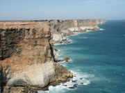
— Located 12 kilometres (7.5 mi) from the WA/SA border, this roadhouse is situated close to the Great Australian BightGreat Australian BightThe Great Australian Bight is a large bight, or open bay, off the central and western portions of the southern coastline of mainland Australia.-Extent:...
. A historic telegraph station, half-buried in sand dunes, can also be viewed nearby.
South Australian section
Nullarbor Plain
The Nullarbor Plain is part of the area of flat, almost treeless, arid or semi-arid country of southern Australia, located on the Great Australian Bight coast with the Great Victoria Desert to its north. It is the world's largest single piece of limestone, and occupies an area of about...
before arriving in the town of Ceduna
Ceduna, South Australia
Ceduna is a small town in the West Coast region of South Australia. It is situated in the northwest corner of Eyre Peninsula, facing the islands of the Nuyts Archipelago. It lies west of the junction of the Flinders and Eyre Highways around 786 km northwest of the capital Adelaide. The port...
. It then skirts the northern boundary of the Eyre Peninsula
Eyre Peninsula
Eyre Peninsula is a triangular peninsula in South Australia. It is bounded on the east by Spencer Gulf, the west by the Great Australian Bight, and the north by the Gawler Ranges. It is named after explorer Edward John Eyre who explored some of it in 1839-1841. The coastline was first explored by...
before reaching the city of Port Augusta
Port Augusta, South Australia
-Electricity generation:Electricity is generated at the Playford B and Northern power stations from brown coal mined at Leigh Creek, 250 km to the north...
. An alternative route between Ceduna and Port Augusta, formerly signed Alternate Route 1 and now signed B100, follows Flinders Highway
Flinders Highway, South Australia
Flinders Highway connects the South Australian towns of Ceduna and Port Lincoln, a distance of 410 kilometres. The highway was formerly designated as National Route Alternate 1 and currently signed as B100...
and Lincoln Highway
Lincoln Highway (Australia)
Lincoln Highway links Port Augusta and Port Lincoln, both located in South Australia, a distance of 327 kilometres. It was formerly designated as National Route Alternate 1 and is currently B100....
down the western and eastern sides of the peninsula respectively.
Localities in this section include:
- NullarborNullarbor, South AustraliaNullarbor is a locality and roadhouse along the Eyre Highway in South Australia. Its name is taken from the surrounding Nullarbor Plain....
- Yalata
- NundrooNundroo, South AustraliaNundroo is a small South Australian town, located approximately west of Adelaide. It is a popular rest stop for travellers due to its location on the Eyre Highway....
- PenongPenong, South AustraliaPenong is a small South Australian town, located on the Nullarbor Plain. Its location on the Eyre Highway makes it a popular rest-stop for travellers....
- CedunaCeduna, South AustraliaCeduna is a small town in the West Coast region of South Australia. It is situated in the northwest corner of Eyre Peninsula, facing the islands of the Nuyts Archipelago. It lies west of the junction of the Flinders and Eyre Highways around 786 km northwest of the capital Adelaide. The port...
— Westernmost big town in South Australia, located near the Great Australian BightGreat Australian BightThe Great Australian Bight is a large bight, or open bay, off the central and western portions of the southern coastline of mainland Australia.-Extent:...
. Offers fishing and whale watching between May and September. - WirrullaWirrulla, South AustraliaWirrulla is a small grain belt town located 60 km from Streaky Bay on the Eyre Peninsula. The town is a focus point for many of the surrounding agricultural districts, and features a number of silos used to store grain from the surrounding areas. The name of the town is derived from an...
- Cungena
- PoocheraPoochera, South AustraliaPoochera is a small grain belt town located 60 km North West of Streaky Bay on the Eyre Peninsula, South Australia. At the 2006 census, Poochera had a population of 185....
— A small town, the entrance of which is distinguished by spectacular native pines. Poochera is the home of the dinosaur ant, the most primitive surviving ant species. - MinnipaMinnipa, South AustraliaMinnipa is a small town serving the local grain growing community located on South Australia's Eyre Peninsula. The area around the town was first settled in 1878 but it wasn't until the arrival of the railway line in 1913 that any kind of township developed. When the railway was opened to Minnipa...
- WudinnaWudinna, South AustraliaWudinna is a town in South Australia. The area was first settled in 1861 when Robert George Standley lodged a claim for 10 sq. miles of land surrounding Weedna Hill .. It was proclaimed a town in 1916...
- Gateway to the Gawler RangesGawler RangesThe Gawler Ranges are a range of stoney hills in South Australia to the north of Eyre Peninsula. The Eyre Highway skirts the south of the ranges. The Gawler Ranges National Park and Gawler Ranges Conservation Reserve are in the ranges north of Wudinna...
and home to the Australian FarmerAustralian FarmerThe Australian Farmer is a statue located in Wudinna, South Australia. Regarded as one of Australia's Big Things, the granite sculpture stands at in height, and weighs in the vicinity of 70 tonnes...
. - KyancuttaKyancutta, South AustraliaKyancutta is a small wheatbelt town located at the junction of the Eyre and Tod Highways on the Eyre Peninsula in South Australia. Once a busy town with an airport, Kyancutta is now nearly a ghost town, acting only as a centre for the agricultural districts surrounding it, as well as passing...
- KimbaKimba, South AustraliaKimba is a rural service town on the Eyre Highway at the top of Eyre Peninsula in South Australia. At the 2006 census, Kimba had a population of 636 and it has an annual rainfall of 339 mm. There is 7 metre tall statue of a big galah beside the highway marking halfway between the east and west...
— a grain-growing and pioneer town, and home to the "Big Galah", an 8 metres (26.2 ft) monument. - Iron KnobIron Knob, South AustraliaIron Knob is a town in South Australia on the Eyre Highway across Eyre Peninsula. At the 2006 census, Iron Knob and the surrounding area had a population of 199....
, off road - Port AugustaPort Augusta, South Australia-Electricity generation:Electricity is generated at the Playford B and Northern power stations from brown coal mined at Leigh Creek, 250 km to the north...
See also
- Highway 1 (Australia)Highway 1 (Australia)Australia's Highway 1 is a network of highways that circumnavigate the Australian continent, joining all mainland state capitals. At a total length of approximately it is the longest national highway in the world, longer than the Trans-Siberian Highway and the Trans-Canada Highway...
- Highways in AustraliaHighways in AustraliaThis is a list of highways in Australia, listed alphabetically along with each highway's route number and location. Note that some highways service more than one state or territory.-Route numbering systems:...
- A1 highway (South Australia)A1 highway (South Australia)The A1 highway, also variously known as National Route 1, National Highway 1, and other names, circumnavigates Australia, mainly following the coastline, connecting all of the mainland state capitals. Refer to Highway 1 for details....
- List of highways in South Australia
- List of highways in Western Australia
- List of roadhouses in Western Australia
External links
- Across the Nullarbor Driving Guide by Roderick Eime
Further reading
- Main Roads, Western Australia (2006) Distance book: distances to towns and localities in Western Australia East Perth, W.A. Main Roads ISBN 0730976688
- Western Australia. Dept. of Tourism. (1978) Eyre highway traveller survey, 1978 : a study of travellers prior and subsequent to sealing of the highway Perth: Western Australian Dept. of Tourism. ISBN 0724478000 (Roads. Use. Australia. Eyre Highway. Reports, surveys (ANB/PRECIS SIN 0061603)