

Geography of Rosario
Encyclopedia
Rosario
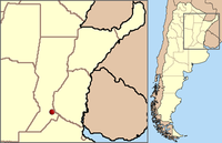
Rosario is the largest city in the province of Santa Fe, Argentina. It is located northwest of Buenos Aires, on the western shore of the Paraná River and has 1,159,004 residents as of the ....
, which is the largest city of the , and the third most populous in the country, after Córdoba
Córdoba, Argentina
Córdoba is a city located near the geographical center of Argentina, in the foothills of the Sierras Chicas on the Suquía River, about northwest of Buenos Aires. It is the capital of Córdoba Province. Córdoba is the second-largest city in Argentina after the federal capital Buenos Aires, with...
and Buenos Aires
Buenos Aires
Buenos Aires is the capital and largest city of Argentina, and the second-largest metropolitan area in South America, after São Paulo. It is located on the western shore of the estuary of the Río de la Plata, on the southeastern coast of the South American continent...
. It is located about 300 km north of Buenos Aires
Buenos Aires
Buenos Aires is the capital and largest city of Argentina, and the second-largest metropolitan area in South America, after São Paulo. It is located on the western shore of the estuary of the Río de la Plata, on the southeastern coast of the South American continent...
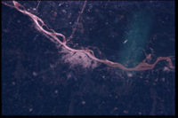
, on the Western shore of the Paraná River
Paraná River
The Paraná River is a river in south Central South America, running through Brazil, Paraguay and Argentina for some . It is second in length only to the Amazon River among South American rivers. The name Paraná is an abbreviation of the phrase "para rehe onáva", which comes from the Tupi language...
, and it has about 910,000 inhabitants. It is surrounded by smaller cities and towns that form a metropolitan area
Metropolitan area
The term metropolitan area refers to a region consisting of a densely populated urban core and its less-populated surrounding territories, sharing industry, infrastructure, and housing. A metropolitan area usually encompasses multiple jurisdictions and municipalities: neighborhoods, townships,...
(Greater Rosario
Greater Rosario
Greater Rosario is the metropolitan area of the city of Rosario, in the province of Santa Fe, Argentina. This metropolis has a population of about 1.5 million , thus being Argentina's second most populated urban settlement, after Buenos Aires....
) with a population of about 1.2 million according to the .
Geographic data
- LatitudeLatitudeIn geography, the latitude of a location on the Earth is the angular distance of that location south or north of the Equator. The latitude is an angle, and is usually measured in degrees . The equator has a latitude of 0°, the North pole has a latitude of 90° north , and the South pole has a...
: parallelCircle of latitudeA circle of latitude, on the Earth, is an imaginary east-west circle connecting all locations that share a given latitude...
s 32º52′18″ and 33º02′22″ South. - LongitudeLongitudeLongitude is a geographic coordinate that specifies the east-west position of a point on the Earth's surface. It is an angular measurement, usually expressed in degrees, minutes and seconds, and denoted by the Greek letter lambda ....
: meridianMeridian (astronomy)This article is about the astronomical concept. For other uses of the word, see Meridian.In the sky, a meridian is an imaginary great circle on the celestial sphere. It passes through the north point on the horizon, through the celestial pole, up to the zenith, through the south point on the...
s 60º36′44″ and 60º47′46″ West.
The geographical center is approximately at 32°57′2"S 60°42′15"W (see also other cities on the same latitude).
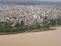
The city is located on a smoothly undulated plain typical of the Pampa
Pampa
The Pampas are the fertile South American lowlands, covering more than , that include the Argentine provinces of Buenos Aires, La Pampa, Santa Fe, Entre Ríos and Córdoba, most of Uruguay, and the southernmost Brazilian State, Rio Grande do Sul...
s, between 22.5 and 24.6 metres above mean sea level
Above mean sea level
The term above mean sea level refers to the elevation or altitude of any object, relative to the average sea level datum. AMSL is used extensively in radio by engineers to determine the coverage area a station will be able to reach...
; the original settlement rests on the ravine
Ravine
A ravine is a landform narrower than a canyon and is often the product of streamcutting erosion. Ravines are typically classified as larger in scale than gullies, although smaller than valleys. A ravine is generally a fluvial slope landform of relatively steep sides, on the order of twenty to...
on the right-hand shore of the Paraná, opposite a group of islands of the Paraná Delta
Paraná Delta
The Paraná Delta is the delta of the Paraná River in Argentina. The Paraná flows north–south and becomes an alluvial basin between the Argentine provinces of Entre Ríos and Santa Fe, then emptying into the Río de la Plata....
which are partly in the jurisdiction of the province of Entre Ríos
Entre Ríos Province
Entre Ríos is a northeastern province of Argentina, located in the Mesopotamia region. It borders the provinces of Buenos Aires , Corrientes and Santa Fe , and Uruguay in the east....
. The nearest city across the river's flood plain (60 km) is Victoria, Entre Ríos
Victoria, Entre Ríos
Victoria is a city in the southwest of the province of Entre Ríos, Argentina. It is located on the eastern shore of the Paraná River, opposite Rosario, Santa Fe, to which it is connected since 2003 by the Rosario-Victoria Bridge .The site of a 1750 defeat of a native uprising and an 1810 oratory to...
, linked to Rosario by the Rosario-Victoria Bridge
Rosario-Victoria Bridge
Rosario-Victoria Bridge is the informal name of the physical connection between the Argentine cities of Rosario and Victoria ....
.
Climate and natural hazards
The Rosario area has a Pampean temperate climateClimate
Climate encompasses the statistics of temperature, humidity, atmospheric pressure, wind, rainfall, atmospheric particle count and other meteorological elemental measurements in a given region over long periods...
. There is a hot season from November to March (with temperature extremes between 18 and 32 ºC), and a cold season between June and mid-August (between 5 and 16 ºC). Summer is rainier than winter. Local residents often complain about high levels of humidity
Humidity
Humidity is a term for the amount of water vapor in the air, and can refer to any one of several measurements of humidity. Formally, humid air is not "moist air" but a mixture of water vapor and other constituents of air, and humidity is defined in terms of the water content of this mixture,...
throughout the year.
The last instance of snow
Snow
Snow is a form of precipitation within the Earth's atmosphere in the form of crystalline water ice, consisting of a multitude of snowflakes that fall from clouds. Since snow is composed of small ice particles, it is a granular material. It has an open and therefore soft structure, unless packed by...
was in the winter of 1973, being clearly an exceptional phenomenon (hail
Hail
Hail is a form of solid precipitation. It consists of balls or irregular lumps of ice, each of which is referred to as a hail stone. Hail stones on Earth consist mostly of water ice and measure between and in diameter, with the larger stones coming from severe thunderstorms...
is not, though it is also quite rare).
Parts of the city are subject to flooding, but large events have historically been exceptional. The possibility of serious earthquake
Earthquake
An earthquake is the result of a sudden release of energy in the Earth's crust that creates seismic waves. The seismicity, seismism or seismic activity of an area refers to the frequency, type and size of earthquakes experienced over a period of time...
s is also remote, and other hazards such as hurricanes and volcanic
Volcano
2. Bedrock3. Conduit 4. Base5. Sill6. Dike7. Layers of ash emitted by the volcano8. Flank| 9. Layers of lava emitted by the volcano10. Throat11. Parasitic cone12. Lava flow13. Vent14. Crater15...
eruptions are virtually impossible.
Central district
Ravine
A ravine is a landform narrower than a canyon and is often the product of streamcutting erosion. Ravines are typically classified as larger in scale than gullies, although smaller than valleys. A ravine is generally a fluvial slope landform of relatively steep sides, on the order of twenty to...
of the right-hand shore of the Paraná River, in a place where the ravine separates from the river and there is a natural slope to the low shore, known as Bajada Sargento Cabral (after sergeant Juan Bautista Cabral
Juan Bautista Cabral
Juan Bautista Cabral was an Argentine soldier of the Regiment of Mounted Grenadiers who died in the Battle of San Lorenzo, while he was aiding then Colonel José de San Martín, whose horse had fallen to enemy fire...
, who died during the Battle of San Lorenzo
Battle of San Lorenzo
The Battle of San Lorenzo was fought on February 3, 1813 in San Lorenzo, Argentina, then part of the United Provinces of the Río de la Plata. A Spanish Royalist army under the command of Antonio Zabala was defeated by the Regiment of Mounted Grenadiers, under the command of José de San Martín...
). For a long time this was the only access to the port, until several cuts were made in the walls of the ravine.
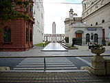
Plaza 25 de Mayo (Rosario)
Plaza 25 de Mayo is a plaza in Rosario, province of Santa Fe, Argentina. It is Rosario's civic center, and the core of the original settlement. Its name alludes to the date of the May Revolution, which led to the establishment of the first local Argentine government in Buenos Aires...
("May 25
May Revolution
The May Revolution was a week-long series of events that took place from May 18 to 25, 1810, in Buenos Aires, capital of the Viceroyalty of the Río de la Plata, a Spanish colony that included roughly the territories of present-day Argentina, Bolivia, Paraguay and Uruguay...
Square"), now surrounded by the Municipality (Palacio de los Leones
Palacio de los Leones
Palacio de los Leones is the name of the main municipal building of the city of Rosario, Argentina. The Palace is the seat of the executive branch of the municipal government...
), the Basilica Cathedral of Our Lady of the Rosary
Basilica Cathedral of Our Lady of the Rosary
The Cathedral Basilica Shrine of Our Lady of the Rosary is a minor basilica and cathedral dedicated to the local Virgin of the Rosary, in the city of Rosario, province of Santa Fe, Argentina. It is the motherchurch of the Archdiocese of Rosario....
, the Central Post Office building, the Decorative Art Museum
Firma y Odilo Estévez Municipal Decorative Art Museum
Firma y Odilo Estévez Municipal Decorative Art Museum is the former home of the Estévez family in Rosario, Argentina, which was donated to the Municipality of Rosario and turned into a museum....
and the emblematic building called La Bola de Nieve ("The Snowball"). The streets follow a remarkably regular pattern called damero (a checkerboard
Checkerboard
A checkerboard or chequerboard is a board of chequered pattern on which English draughts is played. It is an 8×8 board and the 64 squares are of alternating dark and light color, often red and black....
grid), except in the zone around the Bajada Sargento Cabral, where the streets are somewhat more irregular due to terrain features.

Oroño Boulevard
Oroño Boulevard is a street in Rosario, Santa Fe Province, Argentina. It is a two-way boulevard that runs north–south through the center-east of the city, from the coastal avenue by the Paraná River to the southern limit of the urbanized area...
, going from north to south, and Pellegrini Avenue
Pellegrini Avenue (Rosario)
Pellegrini Avenue is a street in Rosario, Santa Fe Province, Argentina. It is a two-way avenue that runs east–west through the center-south of the city, from the coastal avenue by the Paraná River to the western limit of the urbanized area...
, from east to west. These streets, together with the river, mark the boundaries of the town center. Their characters are rather different. Oroño has an air of distinction, it is flanked by old buildings and mansions, and it has a wide central reservation
Central reservation
On divided roads, such as divided highways or freeways/motorways, the central reservation , median, parkway , median strip or central nature strip is the area which separates opposing lanes of traffic...
that is profusely hoisted, with a walking path devoted to pedestrians and cyclists. Pellegrini is wide and noisy, with a high flow of transit; it is one of the commercial centers of the city, where numerous restaurants and ice-cream shops can be found. The beginning of Pellegrini Ave. is flanked by an important public park, the Parque Urquiza
Parque Urquiza
The Parque Urquiza is a public urban park in Rosario, Argentina. It is located in the southeastern end of the city center, on top of the Paraná River ravines. It is bordered by 3 de Febrero St., the coastal Belgrano Avenue, Chacabuco St. and the beginning of Pellegrini Avenue...
.
Córdoba Street (Rosario)
Córdoba Street is one of the most important streets in Rosario, Santa Fe Province, Argentina. It runs east–west through the center of the city, from the coastal avenue by the Paraná River to the western limit of the urbanized area....
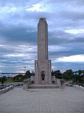
is the main one. Córdoba begins in the park surrounding the National Flag Memorial
National Flag Memorial (Argentina)
The National Flag Memorial in Rosario, Argentina, is a monumental complex built near the shore of the Paraná River...
(probably the single most recognizable landmark in the city), goes up to the city center, and it becomes a pedestrian walk for seven blocks, between Plaza 25 de Mayo and Plaza Pringles
Plaza Pringles (Rosario)
Plaza Pringles is a plaza in Rosario, province of Santa Fe, Argentina. Its name is an homage to Colonel Juan Pascual Pringles, hero of the Spanish American wars of independence .Plaza Pringles occupies a half block in the downtown area of Rosario, beside the...
. Along Córdoba to the west there is the Paseo del Siglo
Paseo del Siglo
Paseo del Siglo is a part of the historical center of the city of Rosario, Argentina. It comprises eight blocks in the downtown Córdoba Street, from Oroño Boulevard east up to Paraguay Street...
("Walk of the Century"), thus called because the houses of the wealthiest families of Rosario at the beginning of the 20th century can be found along Córdoba, from Plaza Pringles to Oroño Boulevard. On Córdoba Street there is also Plaza San Martín
Plaza San Martín (Rosario)
Plaza San Martín is a plaza in Rosario, province of Santa Fe, Argentina. Its name is an homage to General José de San Martín, hero of the Argentine War of Independence....
, surrounded by buildings that formerly housed the Tribunals and the Police, and now the seats of universities, museums and the delegation of the provincial government.
Also in the town center there is Peatonal San Martín (the pedestrian-only four blocks of San Martín Street
San Martín Street (Rosario)
San Martín Street is an important street in Rosario, Santa Fe Province, Argentina. It runs north–south through the center of the city, from the coastal avenue by the Paraná River to the southern limit of the urbanized area...
, from Peatonal Córdoba south up to Mendoza Street), and two large open squares, Plaza Montenegro and Plaza Sarmiento
Plaza Sarmiento (Rosario)
Plaza Sarmiento is a plaza in the city of Rosario, province of Santa Fe, Argentina. Its name is an homage to former Argentine president Domingo Faustino Sarmiento....
, among other important spots. Other important commercial streets are Corrientes, San Luis and Santa Fe.
At the confluence of Oroño and Pellegrini starts the Parque de la Independencia
Parque de la Independencia
The Parque de la Independencia is a large public park in Rosario, province of Santa Fe, Argentina. It is located near the geographical center of the city, its limits defined by Moreno Street and three important avenues: Pellegrini Avenue, Ovidio Lagos Avenue, and 27 de Febrero Boulevard...
("Independence Park"), that houses the Juan B. Castagnino Fine Arts Museum
Juan B. Castagnino Fine Arts Museum
The Juan B. Castagnino Fine Arts Museum is an art museum in the city of Rosario, , considered the most important of the interior of the country and the second in national terms. It is administered by the municipal government...
, the Newell's Old Boys
Newell's Old Boys
Club Atlético Newell's Old Boys is an Argentine sports club based in Rosario. The club was founded on November 3, 1903, and is named after Isaac Newell, one of the pioneers of Argentine football...
football club, and the sports clubs Provincial and Gimnasia y Esgrima, as well as the horse racetrack and the former Sociedad Rural (Rural Society).
Periphery
To the west, after Oroño, there are the avenues Ovidio Lagos and Francia, Avellaneda Boulevard and Provincias Unidas Avenue. The main neighborhoods in the south are La Tablada, Parque Casado, Las Heras, Las Delicias and Las Flores. The city ends in the Saladillo Stream
Saladillo Stream
The Saladillo Stream is a small tributary of the Paraná River, that discharges into it between the cities of Rosario and Villa Gobernador Gálvez, in the...
(the natural border with Villa Gobernador Gálvez
Villa Gobernador Gálvez
Villa Gobernador Gálvez is a city in the province of Santa Fe, Argentina, located on the western ravine of the Paraná River, within the metropolitan area of Greater Rosario. It has 74,509 inhabitants per the . It is separated from Rosario, to the north, by the Saladillo Stream...
).
Among the neighborhoods in the west are Echesortu
Barrio Echesortu
Echesortu is a barrio in Rosario, Argentina. It is unofficially known by that name even though, from the administrative point of view, it name is Remedios Escalada de San Martín...
, Belgrano
Barrio Belgrano (Rosario)
Belgrano is a barrio in the west of Rosario, Argentina. It is named in honor of Manuel Belgrano, creator of the Argentine flag....
, Triángulo, Moderno, Godoy and Fisherton
Barrio Fisherton
Fisherton is a barrio in Rosario, . It is located in the western part of the city. Its main street is Eva Perón Avenue .Fisherton is primarily a middle-class, residential neighborhood...
(near the west end of the city, formerly home of hierarchical personnel of English railroad companies established in Rosario).
.jpg)
Barrio Pichincha
Pichincha is a barrio in the city of Rosario, . It is located on the north-east part of the central area of the city, and its limits are Ovidio Lagos Avenue , Francia Avenue , Rivadavia Avenue, and Salta St.The assembling of this barrio was motivated by the growth of the railway lines and the...
(a red-light district
Red-light district
A red-light district is a part of an urban area where there is a concentration of prostitution and sex-oriented businesses, such as sex shops, strip clubs, adult theaters, etc...
in early 20th century, now home to an open-air antiquities fair
Fair
A fair or fayre is a gathering of people to display or trade produce or other goods, to parade or display animals and often to enjoy associated carnival or funfair entertainment. It is normally of the essence of a fair that it is temporary; some last only an afternoon while others may ten weeks. ...
: Mercado de antigüedades "Feria Retro La Huella"), Ludueña, Lisandro de la Torre
Barrio Lisandro de la Torre
Lisandro de la Torre is a barrio in the north-east of Rosario, Argentina. It carries the name of a renowned local politician, Lisandro de la Torre , but is most commonly referred to as Arroyito....
(home of the Rosario Central
Rosario Central
Club Atlético Rosario Central is a sports club based in Rosario, Argentina. Its football team currently plays in the Primera B Nacional, the second tier of the Argentine football league system, after being relegated in the 2009-10 season....
football club) and Empalme Graneros; these last three are in the influence area of the Ludueña Stream
Ludueña Stream
The Ludueña Stream is a small river in the , which starts near the city of Rosario and flows through it, mostly east-southwards, ending in the Paraná River in the neighbourhood commonly known as Arroyito, near Rosario Central's football stadium.The Ludueña drains an area which includes Rosario...
, now contained by underground piping, but until the 1980s a source of flood
Flood
A flood is an overflow of an expanse of water that submerges land. The EU Floods directive defines a flood as a temporary covering by water of land not normally covered by water...
s.
Next to the Rosario Central stadium there is a large park, Parque Alem
Parque Alem
The Parque Alem is a large public park in Rosario, province of Santa Fe, Argentina. It is located in the north of the city, beside the Paraná River, overlooking its islands...
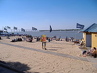
, and not far from it there stands the Sorrento thermoelectric power plant. North from the Lisandro de la Torre neighborhood there are Alberdi
Barrio Alberdi
Alberdi is a primarily residential barrio of Rosario, Argentina. It is located in the north-east of the city, between Rondeau Boulevard and the Paraná River. In the current administrative division system employed by the municipality, it belongs in the North District.This barrio was initially an...
(formerly an independent town), La Florida (with a popular beach resort of the same name) and Rucci.
The main streets in the north are Alberdi Avenue and its continuation, Rondeau Boulevard (which leads to the north exit of the city, the access to the Rosario-Victoria Bridge and the town of Granadero Baigorria
Granadero Baigorria
Granadero Baigorria is a city in the south of the province of Santa Fe, Argentina, located directly north of Rosario, on the western shore of the Paraná River, and forming part of the Greater Rosario metropolitan area...
). These major arteries are crossed by several avenues: Las Tres Vías, Génova, Sorrento and Puccio.
The coast
Parque de España
The Parque de España is an urban complex in Rosario, Argentina. It comprises the park and a cultural centre, with a total surface area of 10,000 m², located near the historical centre of the city, on the coast of the Paraná River....
, Parque de las Colectividades and Parque Sunchales.
The Parque de España was funded by Spain's government and was inaugurated in 1993 in the presence of the King and Queen of Spain. The park connects the low shore with the ravine by stairs, under which a culture center is built. The culture center was the seat of some events of the Third International Congress of the Spanish Language
Third International Congress of the Spanish Language
The Third International Congress of the Spanish Language was a cultural event that took place in Rosario, Argentina, on 17, 18 and 19 November 2004....
(which took place wholly in Rosario, from November 17 to November 20, 2004).
Origin of names
- Pellegrini Avenue, Avellaneda Boulevard and Plaza Sarmiento are named after presidentsPresident of ArgentinaThe President of the Argentine Nation , usually known as the President of Argentina, is the head of state of Argentina. Under the national Constitution, the President is also the chief executive of the federal government and Commander-in-Chief of the armed forces.Through Argentine history, the...
, Carlos PellegriniCarlos PellegriniCarlos Enrique José Pellegrini Bevans was President of Argentina from 6 August 1890 to 12 October 1892....
, Nicolás AvellanedaNicolás AvellanedaNicolás Remigio Aurelio Avellaneda Silva was an Argentine politician and journalist, and president of Argentina from 1874 to 1880. Avellaneda's main projects while in office were banking and education reform, leading to Argentina's economic growth...
and Domingo Faustino SarmientoDomingo Faustino SarmientoDomingo Faustino Sarmiento was an Argentine activist, intellectual, writer, statesman and the seventh President of Argentina. His writing spanned a wide range of genres and topics, from journalism to autobiography, to political philosophy and history...
. Two downtown streets are named after the rival caudilloCaudilloCaudillo is a Spanish word for "leader" and usually describes a political-military leader at the head of an authoritarian power. The term translates into English as leader or chief, or more pejoratively as warlord, dictator or strongman. Caudillo was the term used to refer to the charismatic...
s Justo José de UrquizaJusto José de UrquizaJusto José de Urquiza y García was an Argentine general and politician. He was president of the Argentine Confederation from 1854 to 1860.He was governor of Entre Ríos during the government of Juan Manuel de Rosas, governor of Buenos Aires with powers delegated from the other provinces...
and Juan Manuel de RosasJuan Manuel de RosasJuan Manuel de Rosas , was an argentine militar and politician, who was elected governor of the province of Buenos Aires in 1829 to 1835, and then of the Argentine Confederation from 1835 until 1852...
. - San Martín St. and Plaza San Martín are of course named after the Liberator, General José de San MartínJosé de San MartínJosé Francisco de San Martín, known simply as Don José de San Martín , was an Argentine general and the prime leader of the southern part of South America's successful struggle for independence from Spain.Born in Yapeyú, Corrientes , he left his mother country at the...
. - The coastal Belgrano Avenue, which runs before the Flag Memorial, is named after Manuel BelgranoManuel BelgranoManuel José Joaquín del Corazón de Jesús Belgrano , usually referred to as Manuel Belgrano, was an Argentine economist, lawyer, politician, and military leader. He took part in the Argentine Wars of Independence and created the Flag of Argentina...
, creator of the Argentine flag. - The Lisandro de la Torre neighborhood, named after a distinguished politician from RosarioLisandro de la TorreLisandro de la Torre was an Argentine politician, born in Rosario, province of Santa Fe.De la Torre became a lawyer in 1890. His thesis about municipalities and communes, as well as other works of his, gave rise to the idea of municipal autonomy in Argentina, which was included in the Argentine...
, is more commonly known as Arroyito, "Little Creek" (a reference to the Ludueña Stream). The Alem Park, also located in this area, is named after Leandro AlemLeandro AlemLeandro Nicéforo Alem was an Argentine politician, born in Buenos Aires, a founder and leader of the Radical Civic Union. Alem was the uncle and political teacher of Hipólito Yrigoyen. His father, was the chief of Rosas' political police, the Mazorca. He was executed after the battle of Caseros...
, founder of the Radical Civic UnionRadical Civic UnionThe Radical Civic Union is a political party in Argentina. The party's positions on issues range from liberal to social democratic. The UCR is a member of the Socialist International. Founded in 1891 by radical liberals, it is the oldest political party active in Argentina...
. - Córdoba Avenue becomes Eva PerónEva PerónMaría Eva Duarte de Perón was the second wife of President Juan Perón and served as the First Lady of Argentina from 1946 until her death in 1952. She is often referred to as simply Eva Perón, or by the affectionate Spanish language diminutive Evita.She was born in the village of Los Toldos in...
Avenue outside of the town center, and former Godoy Avenue was renamed Presidente PerónJuan PerónJuan Domingo Perón was an Argentine military officer, and politician. Perón was three times elected as President of Argentina though he only managed to serve one full term, after serving in several government positions, including the Secretary of Labor and the Vice Presidency...
Avenue. - Many streets in the town center are named after provincesProvinces of ArgentinaArgentina is subdivided into twenty-three provinces and one autonomous city...
: Buenos Aires, Santa Fe, Córdoba, Rioja, San Luis, San Juan, Mendoza, Corrientes, Entre Ríos. - A few streets are named with dates: 3 de Febrero (February 3, day of the Battle of San LorenzoBattle of San LorenzoThe Battle of San Lorenzo was fought on February 3, 1813 in San Lorenzo, Argentina, then part of the United Provinces of the Río de la Plata. A Spanish Royalist army under the command of Antonio Zabala was defeated by the Regiment of Mounted Grenadiers, under the command of José de San Martín...
), 9 de Julio (July 9, Independence Day), 27 de Febrero (February 27, date of creation of the national flag), Primero de Mayo (May 1, Labor DayLabor DayLabor Day is a United States federal holiday observed on the first Monday in September that celebrates the economic and social contributions of workers.-History:...
). - There are streets with names of countries: Italia (Italy), España (Spain), Paraguay; and of cities: Buenos Aires, Montevideo.
Sources
- Municipalidad de Rosario (Municipality of Rosario website, geographic information, in Spanish).
- Article on Rosario in the Spanish Wikipedia.