

Geography of Macau
Encyclopedia
Macau
is a city on the southern coast of China
. It is located at the south of Guangdong
Province, on the tip of the peninsula
formed by the Zhujiang
(Pearl River) estuary
on the east and the Xijiang
(West River) on the west. Macau is situated 60 km west of Hong Kong
and 145 km southwest of Guangzhou
, the capital of Guangdong Province. It is immediately adjacent to the Zhuhai
Special Economic Zone
.
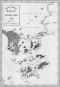
The region comprises the Macau Peninsula
and the islands of Taipa
and Coloane
. Macau was once an island
but gradually a connecting sandbar turned into a narrow isthmus
. Land reclamation
in the 17th century made Macau into a peninsula, and a barrier gate was built to mark the separation between the peninsula and the mainland. Pre-colonial records show that Macau totaled only 2.78 square kilometre but began to increase as a result of Portuguese settlement. Land growth has accelerated since the last quarter of the 20th century, from 15 square kilometre in 1972 to 16.1 square kilometre in 1983 to 21.3 square kilometre square kilometers in 1994. Macau's size has gradually increased as result of continued land reclamation, especially on Taipa and Coloane. In 2010, the total land area was approximately 29.7 km².
There is a 0.34 km (0.211266730460934 mi) long border between Macau and mainland China
and a forty-kilometer-long coastline. The main border crossing between Macau and China is the Portas do Cerco
(Barrier Gate) Frontier Checkpoint on the Macau side, and the Gongbei checkpoint on the Chinese side.
Area:
total: 29.7 km²
land: 29.7 km²
water: 0 km²
Land boundaries:
total: 0.34 km
border city: Zhuhai
, Guangdong
Province 0.34 km
Coastline: 40 km
Maritime claims: not specified
 Location: Eastern Asia, bordering the South China Sea
and China
Terrain: generally flat
Elevation extremes:
lowest point: South China Sea 0 m
highest point: Coloane Alto
174 m (570.9 ft)
Macau has generally flat terrain resulting from extensive land reclamation, but numerous steep hills mark the original natural land mass. The modern high-rise skyline of Macau obscures much of the hilly landscape. The Macau skyline both defines and obscures its topography.
The Macau Peninsula
is narrow in shape but varies in terrain
:
The East Ocean Watching Hill, West Ocean Watching Hill, Persimmon Hill, Lotus Hill, Luosi Hill and Qingzhou Hill are famous scenic spots in Macau. The Persimmon Hill used to be a fortress surrounded by stone walls. The fortress, which resembles an imposing Europe
an castle
, is now a tourist attraction. Standing on the Persimmon Hill, one gains a panoramic view of both Macau and the nearby Zhuhai
.
The West Ocean Watching Hill, a tranquil scenic spot, is noted for the cathedral
and the bishop
's mansion on its top. Viewed from the Nanxi Bay in the distance, particularly against the evening glow, the cathedral and the mansion stand in their full splendor. From the top of the Persimmon Hill, one sees the Nanxi Bay and the high rise buildings there as well as the sea and the sea - spanning bridge
.
(Köppen climate classification
Cwa), because the Siberian pressure system in the winter pushes cool air further south than similar semipermanent permanent high pressure systems. Its average year-round temperature is 22.7 °C (72.9 °F). Summers are very hot and humid: the July average temperature is 28.9 °C (84 °F) and the highest daytime temperature could reach 35 °C (95 °F). However, the heat is generally less intense than many places in mainland China due to the coastal location. Winters are short and mild: the January average is 15 °C (59 °F) and the lowest temperature could drop to 5 °C (41 °F), but very rarely any lower. There is about 2120 millimetres (83 in) of rainfall annually, with drier winters.
Macau is exposed to tropical storms originating from the southern Pacific Ocean
during the summer. Major destruction occurred in September 1874, when a devastating typhoon hit Macau and high seas swept across the low-lying area of the peninsula. There are always a few tropical storm occurrences in Macau each year (typically between May to October), although they vary in strengths. When they occur, they usually bring strong winds, rainfall and lower temperatures.
Prevailing winds and weather types change follow the monsoon pattern. It is warm and moist when the southeast and southwest winds coming from Pacific Ocean, and typhoons are relatively common during summertime; and is dry and slightly cold when the north winds coming from Siberia or the northern part of Mainland China.
During the transition period from northeast monsoon to southwest monsoon (March and April), the weather is moist and foggy. It is Macau's spring season. Summer is from May to September, when the southeast and southwest monsoon prevailing. It is rather hot and rainy. The weather in autumn (the end of September and October) is sunny and warm, when the southwest monsoon withdrawing gradually and the northeast monsoon advancing south. It is generally regarded as the most comfortable season there. Winter is from November to February next year, when the northeast monsoon prevailing. It is mainly dry, with occasional cold fronts arriving.
There are moderate to high levels of humidity year-round, with an annual average of 79.3%. Annual sunshine totals are moderate, at more than 1800 hours.
were extracted from Macau's hills for use as building material
.
, Macau is at present suffering its worst ever crisis of salinity in freshwater
during dry season in 2006 which takes place in late winter and early spring time. The salinity
level of freshwater
has recently aggrandized far above the standard set up by the World Health Organization
or WHO
.
By the end of 2007, Macau will be able to solve the problem of tap-water supply with relatively high level of salinity after the completion of the Ping Gang project. This project is aimed at shifting the intake of raw-water on the Xijiang River
20 km upstream in order to give a wide berth to the salt tide in the province of Guangdong
.
 No arable land, pastures, forest, or woodland. Because of this deficiency, Macau's people traditionally have looked to the sea for their livelihood.
arable land: 0%
permanent crops: 2%
permanent pastures: 0%
forests and woodland: 0%
other: 98% (1998 est.)
In 2010 plans were announced for an additional 3.5 square kilometres of land reclamation in Macau, to be carried out over five years and divided into six phases. These areas cover an area east of the Outer Harbour Ferry Terminal, an area south of Avenida Sun Yat Sen, and the north side of Taipa Island.
The change of total area of Macau (in km square) since the year of 1912:
Geography - note: essentially urban; three bridges connect the two islands of Coloane and Taipa to the peninsula on mainland, and an isthmus connects Coloane and Taipa.
Macau
Macau , also spelled Macao , is, along with Hong Kong, one of the two special administrative regions of the People's Republic of China...
is a city on the southern coast of China
China
Chinese civilization may refer to:* China for more general discussion of the country.* Chinese culture* Greater China, the transnational community of ethnic Chinese.* History of China* Sinosphere, the area historically affected by Chinese culture...
. It is located at the south of Guangdong
Guangdong
Guangdong is a province on the South China Sea coast of the People's Republic of China. The province was previously often written with the alternative English name Kwangtung Province...
Province, on the tip of the peninsula
Peninsula
A peninsula is a piece of land that is bordered by water on three sides but connected to mainland. In many Germanic and Celtic languages and also in Baltic, Slavic and Hungarian, peninsulas are called "half-islands"....
formed by the Zhujiang
Pearl River (China)
The Pearl River or less commonly, the "Guangdong River" or "Canton River" etc., , is an extensive river system in southern China. The name Pearl River is usually used as a catchment term to refer to the watersheds of the Xi Jiang , the Bei Jiang , and the Dong Jiang...
(Pearl River) estuary
Estuary
An estuary is a partly enclosed coastal body of water with one or more rivers or streams flowing into it, and with a free connection to the open sea....
on the east and the Xijiang
Xijiang River
The Xi River is the western tributary of the Pearl River in China. It is formed by the confluence of the Gui and Xun Rivers in Wuzhou, Guangxi. It then flows east through Guangdong, and enters the Pearl River Delta just east of the Lingyang Gorge in Zhaoqing. The main branch of the Xi flows...
(West River) on the west. Macau is situated 60 km west of Hong Kong
Hong Kong
Hong Kong is one of two Special Administrative Regions of the People's Republic of China , the other being Macau. A city-state situated on China's south coast and enclosed by the Pearl River Delta and South China Sea, it is renowned for its expansive skyline and deep natural harbour...
and 145 km southwest of Guangzhou
Guangzhou
Guangzhou , known historically as Canton or Kwangchow, is the capital and largest city of the Guangdong province in the People's Republic of China. Located in southern China on the Pearl River, about north-northwest of Hong Kong, Guangzhou is a key national transportation hub and trading port...
, the capital of Guangdong Province. It is immediately adjacent to the Zhuhai
Zhuhai
Zhuhai is a prefecture-level city on the southern coast of Guangdong province in the People's Republic of China. Located in the Pearl River Delta, Zhuhai borders Jiangmen to the northwest, Zhongshan to the north, and Macau to the south. Zhuhai was one of the original Special Economic Zones...
Special Economic Zone
Special Economic Zone
A Special Economic Zone is a geographical region that has economic and other laws that are more free-market-oriented than a country's typical or national laws...
.
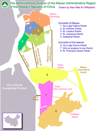
The region comprises the Macau Peninsula
Macau Peninsula
Macau Peninsula is the oldest and most populous part of Macau. It has an area of 8.5 km² and is geographically connected to Guandong province, at the northeast, through an isthmus 200-metre wide. The peninsula, together with the city centre of Zhuhai, sits on an island separated from the...
and the islands of Taipa
Taipa
Taipa is the smaller of the two islands in the Chinese special administrative region of Macao .- Geography :It is 2.5 kilometres from Macau Peninsula and east of the Lesser Hengqin Island of Zhuhai, Guangdong Province...
and Coloane
Coloane
Coloane is one of the two main islands of the Macau Special Administrative Region, located directly south of Macau's other main island, Taipa , and east of Hengqin Island of Zhuhai in Guangdong province....
. Macau was once an island
Island
An island or isle is any piece of sub-continental land that is surrounded by water. Very small islands such as emergent land features on atolls can be called islets, cays or keys. An island in a river or lake may be called an eyot , or holm...
but gradually a connecting sandbar turned into a narrow isthmus
Isthmus
An isthmus is a narrow strip of land connecting two larger land areas usually with waterforms on either side.Canals are often built through isthmuses where they may be particularly advantageous to create a shortcut for marine transportation...
. Land reclamation
Land reclamation
Land reclamation, usually known as reclamation, is the process to create new land from sea or riverbeds. The land reclaimed is known as reclamation ground or landfill.- Habitation :...
in the 17th century made Macau into a peninsula, and a barrier gate was built to mark the separation between the peninsula and the mainland. Pre-colonial records show that Macau totaled only 2.78 square kilometre but began to increase as a result of Portuguese settlement. Land growth has accelerated since the last quarter of the 20th century, from 15 square kilometre in 1972 to 16.1 square kilometre in 1983 to 21.3 square kilometre square kilometers in 1994. Macau's size has gradually increased as result of continued land reclamation, especially on Taipa and Coloane. In 2010, the total land area was approximately 29.7 km².
There is a 0.34 km (0.211266730460934 mi) long border between Macau and mainland China
Mainland China
Mainland China, the Chinese mainland or simply the mainland, is a geopolitical term that refers to the area under the jurisdiction of the People's Republic of China . According to the Taipei-based Mainland Affairs Council, the term excludes the PRC Special Administrative Regions of Hong Kong and...
and a forty-kilometer-long coastline. The main border crossing between Macau and China is the Portas do Cerco
Portas do Cerco
Portas do Cerco is an area on the Macau Peninsula , in the former Portuguese colony of Macau, now a Special Administrative Region of the People's Republic of China, near the border checkpoint with the rest of the People's Republic of China at Gongbei, Zhuhai, Guangdong Province...
(Barrier Gate) Frontier Checkpoint on the Macau side, and the Gongbei checkpoint on the Chinese side.
Location, size, border, and coastline
Geographic coordinates: 22°10′N 113°33′EArea:
total: 29.7 km²
land: 29.7 km²
water: 0 km²
Land boundaries:
total: 0.34 km
border city: Zhuhai
Zhuhai
Zhuhai is a prefecture-level city on the southern coast of Guangdong province in the People's Republic of China. Located in the Pearl River Delta, Zhuhai borders Jiangmen to the northwest, Zhongshan to the north, and Macau to the south. Zhuhai was one of the original Special Economic Zones...
, Guangdong
Guangdong
Guangdong is a province on the South China Sea coast of the People's Republic of China. The province was previously often written with the alternative English name Kwangtung Province...
Province 0.34 km
Coastline: 40 km
Maritime claims: not specified
Topography
South China Sea
The South China Sea is a marginal sea that is part of the Pacific Ocean, encompassing an area from the Singapore and Malacca Straits to the Strait of Taiwan of around...
and China
China
Chinese civilization may refer to:* China for more general discussion of the country.* Chinese culture* Greater China, the transnational community of ethnic Chinese.* History of China* Sinosphere, the area historically affected by Chinese culture...
Terrain: generally flat
Elevation extremes:
lowest point: South China Sea 0 m
highest point: Coloane Alto
Coloane Alto
Coloane Alto at 172 metres above sea level is the highest point of Macau, a former Portuguese colony and since 1999 a special administrative region of the People's Republic of China .-External links: , iTouchMap....
174 m (570.9 ft)
Macau has generally flat terrain resulting from extensive land reclamation, but numerous steep hills mark the original natural land mass. The modern high-rise skyline of Macau obscures much of the hilly landscape. The Macau skyline both defines and obscures its topography.
The Macau Peninsula
Peninsula
A peninsula is a piece of land that is bordered by water on three sides but connected to mainland. In many Germanic and Celtic languages and also in Baltic, Slavic and Hungarian, peninsulas are called "half-islands"....
is narrow in shape but varies in terrain
Terrain
Terrain, or land relief, is the vertical and horizontal dimension of land surface. When relief is described underwater, the term bathymetry is used...
:
The East Ocean Watching Hill, West Ocean Watching Hill, Persimmon Hill, Lotus Hill, Luosi Hill and Qingzhou Hill are famous scenic spots in Macau. The Persimmon Hill used to be a fortress surrounded by stone walls. The fortress, which resembles an imposing Europe
Europe
Europe is, by convention, one of the world's seven continents. Comprising the westernmost peninsula of Eurasia, Europe is generally 'divided' from Asia to its east by the watershed divides of the Ural and Caucasus Mountains, the Ural River, the Caspian and Black Seas, and the waterways connecting...
an castle
Castle
A castle is a type of fortified structure built in Europe and the Middle East during the Middle Ages by European nobility. Scholars debate the scope of the word castle, but usually consider it to be the private fortified residence of a lord or noble...
, is now a tourist attraction. Standing on the Persimmon Hill, one gains a panoramic view of both Macau and the nearby Zhuhai
Zhuhai
Zhuhai is a prefecture-level city on the southern coast of Guangdong province in the People's Republic of China. Located in the Pearl River Delta, Zhuhai borders Jiangmen to the northwest, Zhongshan to the north, and Macau to the south. Zhuhai was one of the original Special Economic Zones...
.
The West Ocean Watching Hill, a tranquil scenic spot, is noted for the cathedral
Cathedral
A cathedral is a Christian church that contains the seat of a bishop...
and the bishop
Bishop
A bishop is an ordained or consecrated member of the Christian clergy who is generally entrusted with a position of authority and oversight. Within the Catholic Church, Eastern Orthodox, Oriental Orthodox Churches, in the Assyrian Church of the East, in the Independent Catholic Churches, and in the...
's mansion on its top. Viewed from the Nanxi Bay in the distance, particularly against the evening glow, the cathedral and the mansion stand in their full splendor. From the top of the Persimmon Hill, one sees the Nanxi Bay and the high rise buildings there as well as the sea and the sea - spanning bridge
Bridge
A bridge is a structure built to span physical obstacles such as a body of water, valley, or road, for the purpose of providing passage over the obstacle...
.
Climate
Although Macau is located in the tropics, it has a humid subtropical climateHumid subtropical climate
A humid subtropical climate is a climate zone characterized by hot, humid summers and mild to cool winters...
(Köppen climate classification
Köppen climate classification
The Köppen climate classification is one of the most widely used climate classification systems. It was first published by Crimea German climatologist Wladimir Köppen in 1884, with several later modifications by Köppen himself, notably in 1918 and 1936...
Cwa), because the Siberian pressure system in the winter pushes cool air further south than similar semipermanent permanent high pressure systems. Its average year-round temperature is 22.7 °C (72.9 °F). Summers are very hot and humid: the July average temperature is 28.9 °C (84 °F) and the highest daytime temperature could reach 35 °C (95 °F). However, the heat is generally less intense than many places in mainland China due to the coastal location. Winters are short and mild: the January average is 15 °C (59 °F) and the lowest temperature could drop to 5 °C (41 °F), but very rarely any lower. There is about 2120 millimetres (83 in) of rainfall annually, with drier winters.
Macau is exposed to tropical storms originating from the southern Pacific Ocean
Pacific Ocean
The Pacific Ocean is the largest of the Earth's oceanic divisions. It extends from the Arctic in the north to the Southern Ocean in the south, bounded by Asia and Australia in the west, and the Americas in the east.At 165.2 million square kilometres in area, this largest division of the World...
during the summer. Major destruction occurred in September 1874, when a devastating typhoon hit Macau and high seas swept across the low-lying area of the peninsula. There are always a few tropical storm occurrences in Macau each year (typically between May to October), although they vary in strengths. When they occur, they usually bring strong winds, rainfall and lower temperatures.
Prevailing winds and weather types change follow the monsoon pattern. It is warm and moist when the southeast and southwest winds coming from Pacific Ocean, and typhoons are relatively common during summertime; and is dry and slightly cold when the north winds coming from Siberia or the northern part of Mainland China.
During the transition period from northeast monsoon to southwest monsoon (March and April), the weather is moist and foggy. It is Macau's spring season. Summer is from May to September, when the southeast and southwest monsoon prevailing. It is rather hot and rainy. The weather in autumn (the end of September and October) is sunny and warm, when the southwest monsoon withdrawing gradually and the northeast monsoon advancing south. It is generally regarded as the most comfortable season there. Winter is from November to February next year, when the northeast monsoon prevailing. It is mainly dry, with occasional cold fronts arriving.
There are moderate to high levels of humidity year-round, with an annual average of 79.3%. Annual sunshine totals are moderate, at more than 1800 hours.
Natural resources
Negligible. In the past, large amounts of graniteGranite
Granite is a common and widely occurring type of intrusive, felsic, igneous rock. Granite usually has a medium- to coarse-grained texture. Occasionally some individual crystals are larger than the groundmass, in which case the texture is known as porphyritic. A granitic rock with a porphyritic...
were extracted from Macau's hills for use as building material
Building material
Building material is any material which is used for a construction purpose. Many naturally occurring substances, such as clay, sand, wood and rocks, even twigs and leaves have been used to construct buildings. Apart from naturally occurring materials, many man-made products are in use, some more...
.
Fresh water
Relying on the water supply of Xijiang RiverXijiang River
The Xi River is the western tributary of the Pearl River in China. It is formed by the confluence of the Gui and Xun Rivers in Wuzhou, Guangxi. It then flows east through Guangdong, and enters the Pearl River Delta just east of the Lingyang Gorge in Zhaoqing. The main branch of the Xi flows...
, Macau is at present suffering its worst ever crisis of salinity in freshwater
Freshwater
Fresh water is naturally occurring water on the Earth's surface in ice sheets, ice caps, glaciers, bogs, ponds, lakes, rivers and streams, and underground as groundwater in aquifers and underground streams. Fresh water is generally characterized by having low concentrations of dissolved salts and...
during dry season in 2006 which takes place in late winter and early spring time. The salinity
Salinity
Salinity is the saltiness or dissolved salt content of a body of water. It is a general term used to describe the levels of different salts such as sodium chloride, magnesium and calcium sulfates, and bicarbonates...
level of freshwater
Freshwater
Fresh water is naturally occurring water on the Earth's surface in ice sheets, ice caps, glaciers, bogs, ponds, lakes, rivers and streams, and underground as groundwater in aquifers and underground streams. Fresh water is generally characterized by having low concentrations of dissolved salts and...
has recently aggrandized far above the standard set up by the World Health Organization
World Health Organization
The World Health Organization is a specialized agency of the United Nations that acts as a coordinating authority on international public health. Established on 7 April 1948, with headquarters in Geneva, Switzerland, the agency inherited the mandate and resources of its predecessor, the Health...
or WHO
Who
Who may refer to:* Who , an English-language pronoun* who , a Unix command* Who?, one of the Five Ws in journalism- Art and entertainment :* Who? , a 1958 novel by Algis Budrys...
.
By the end of 2007, Macau will be able to solve the problem of tap-water supply with relatively high level of salinity after the completion of the Ping Gang project. This project is aimed at shifting the intake of raw-water on the Xijiang River
Xijiang River
The Xi River is the western tributary of the Pearl River in China. It is formed by the confluence of the Gui and Xun Rivers in Wuzhou, Guangxi. It then flows east through Guangdong, and enters the Pearl River Delta just east of the Lingyang Gorge in Zhaoqing. The main branch of the Xi flows...
20 km upstream in order to give a wide berth to the salt tide in the province of Guangdong
Guangdong
Guangdong is a province on the South China Sea coast of the People's Republic of China. The province was previously often written with the alternative English name Kwangtung Province...
.
Land use and reclamation
arable land: 0%
permanent crops: 2%
permanent pastures: 0%
forests and woodland: 0%
other: 98% (1998 est.)
In 2010 plans were announced for an additional 3.5 square kilometres of land reclamation in Macau, to be carried out over five years and divided into six phases. These areas cover an area east of the Outer Harbour Ferry Terminal, an area south of Avenida Sun Yat Sen, and the north side of Taipa Island.
The change of total area of Macau (in km square) since the year of 1912:
| Year | Area of Macau Peninsula | Area of Taipa | Area of Coloane | Area of Cotai Cotai Cotai is a 5.2 km2 piece of newly reclaimed land between Taipa and Coloane islands in Macau, that has not yet been assigned to any of the freguesias. The Chinese and Portuguese names are a portmanteau of the two islands, Coloane and Taipa.... |
Total area of Macau |
|---|---|---|---|---|---|
| 1912 | 3.4* | 2.3 | 5.9 | —— | 11.6 |
| 1936 | 5.2 | 2.6 | 6.0 | —— | 13.8 |
| 1957 | 5.5 | 3.3 | 6.3 | —— | 15.1 |
| 1986 | 5.8 | 3.7 | 7.1 | —— | 16.6 |
| 1991 | 6.5 | 4.0 | 7.6 | —— | 18.1 |
| 1996 | 7.7 | 5.8 | 7.6 | —— | 21.3 |
| 1999 | 7.8 | 6.2 | 7.6 | —— | 23.8 |
| 2000 | 8.5 | 6.2 | 7.6 | —— | 25.4 |
| 2001 | 8.5 | 6.2 | 7.6 | 3.5 | 25.8 |
| 2002 | 8.5 | 6.2 | 7.6 | 4.5 | 26.8 |
| 2003 | 8.7 | 6.2 | 7.6 | 4.7 | 27.3 |
| 2004 | 8.8 | 6.4 | 7.6 | 4.7 | 27.5 |
| 2005 | 8.9 | 28.2 | |||
| 2006 | 28.6 |
Environmental factors
Dense urban environment.Geography - note: essentially urban; three bridges connect the two islands of Coloane and Taipa to the peninsula on mainland, and an isthmus connects Coloane and Taipa.
See also
- Geography of ChinaGeography of ChinaChina stretches some across the East Asian landmass bordering the East China Sea, Korea Bay, Yellow Sea, and South China Sea, between North Korea and Vietnam in a changing configuration of broad plains, expansive deserts, and lofty mountain ranges, including vast areas of inhospitable terrain...
- Geography of the People's Republic of China
- Geography of Hong KongGeography of Hong KongThe geography of Hong Kong primarily consists of three main territories: Hong Kong Island, Kowloon Peninsula, and the New Territories.The name "Hong Kong", literally meaning "fragrant harbour", is derived from the area around present-day Aberdeen on Hong Kong Island, where fragrant wood products...