
Geography of Hong Kong
Overview
Geography
Geography is the science that studies the lands, features, inhabitants, and phenomena of Earth. A literal translation would be "to describe or write about the Earth". The first person to use the word "geography" was Eratosthenes...
of Hong Kong
Hong Kong
Hong Kong is one of two Special Administrative Regions of the People's Republic of China , the other being Macau. A city-state situated on China's south coast and enclosed by the Pearl River Delta and South China Sea, it is renowned for its expansive skyline and deep natural harbour...
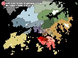
primarily consists of three main territories: Hong Kong Island
Hong Kong Island
Hong Kong Island is an island in the southern part of the Hong Kong Special Administrative Region. It has a population of 1,289,500 and its population density is 16,390/km², as of 2008...
, Kowloon Peninsula
Kowloon Peninsula
The Kowloon Peninsula is a peninsula that forms the southern part of the main landmass in the territory of Hong Kong. The Kowloon Peninsula and the area of New Kowloon are collectively known as Kowloon....
, and the New Territories
New Territories
New Territories is one of the three main regions of Hong Kong, alongside Hong Kong Island and the Kowloon Peninsula. It makes up 86.2% of Hong Kong's territory. Historically, it is the region described in The Convention for the Extension of Hong Kong Territory...
.
The name "Hong Kong", literally meaning "fragrant harbour", is derived from the area around present-day Aberdeen on Hong Kong Island
Hong Kong Island
Hong Kong Island is an island in the southern part of the Hong Kong Special Administrative Region. It has a population of 1,289,500 and its population density is 16,390/km², as of 2008...
, where fragrant wood products and fragrant incense were once traded. The narrow body of water separating Hong Kong Island and Kowloon Peninsula, Victoria Harbour
Victoria Harbour
Victoria Harbour is a natural landform harbour situated between Hong Kong Island and the Kowloon Peninsula in Hong Kong. The harbour's deep, sheltered waters and strategic location on the South China Sea were instrumental in Hong Kong's establishment as a British colony and its subsequent...
, is one of the deepest natural maritime port
Port
A port is a location on a coast or shore containing one or more harbors where ships can dock and transfer people or cargo to or from land....
s in the world.Hong Kong and its 260 territorial islands and peninsulas are located in the South China Sea
South China Sea
The South China Sea is a marginal sea that is part of the Pacific Ocean, encompassing an area from the Singapore and Malacca Straits to the Strait of Taiwan of around...
, at the mouth of the Pearl River Delta
Pearl River Delta
The Pearl River Delta , Zhujiang Delta or Zhusanjiao in Guangdong province, People's Republic of China is the low-lying area surrounding the Pearl River estuary where the Pearl River flows into the South China Sea...
.
The Kowloon Peninsula to the south of Boundary Street
Boundary Street
[[Image:Boundary st hongkong.JPG|thumb|right|250px|Boundary Street near [[Kowloon Tong]]Boundary Street is a three-lane one-way street in [[Kowloon]], [[Hong Kong]]...
and the New Territories
New Territories
New Territories is one of the three main regions of Hong Kong, alongside Hong Kong Island and the Kowloon Peninsula. It makes up 86.2% of Hong Kong's territory. Historically, it is the region described in The Convention for the Extension of Hong Kong Territory...
to the north of Hong Kong Island were added to Colonial Hong Kong
Colonial Hong Kong
In the 19th century the British, Dutch, French, Indians and Americans saw Imperial China as the world's largest untapped market. In 1840 the British Empire launched their first and one of the most aggressive expeditionary forces to claim the territory that would later be known as Hong Kong.In a few...
in 1860 and 1898 respectively.
Discussions