
Geography of China
Encyclopedia
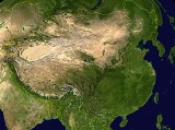
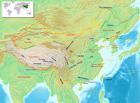
China stretches some 5026 kilometres (3,123 mi) across the East Asia
n landmass bordering the East China Sea
, Korea Bay
, Yellow Sea
, and South China Sea
, between North Korea
and Vietnam
in a changing configuration of broad plains, expansive desert
s, and lofty mountain range
s, including vast areas of inhospitable terrain. The eastern half of the country, its seacoast fringed with offshore islands, is a region of fertile lowlands, foothills and mountains, desert
s, steppe
s, and subtropical areas. The western half of China is a region of sunken basin
s, rolling plateau
s, and towering massif
s, including a portion of the highest tableland on earth.
In spite of many good harbors along the approximately 18,000-kilometer coastline, the nation has traditionally oriented itself not toward the sea but inland, developing as an imperial power whose center lay in the middle and lower reaches of the Yellow River
on the northern plains. China also has the Tibetan Plateau
, a very large, high altitude plateau, to the south. To the north of the Tibetan Plateau lie the Gobi
and Taklamakan
deserts, which stretch from the extreme northwest eastward through Mongolia
.
The People's Republic of China is one of the world's largest countries in total area behind Russia
and Canada
, and very similar to the United States
. Figures for the size of China differ slightly depending on where one draws a number of ill-defined boundaries, including claims by the PRC on territories such as Taiwan
, Aksai Chin
, Trans-Karakoram Tract
, and South Tibet
. The official figure by the People's Republic of China
is 9.6 million square kilometers. The Republic of China
based in Taiwan
but claiming to be the government of China puts this figure at 11 million square kilometres, but this includes Mongolia
, a state whose sovereignty has been recognized by the PRC. China's contour is reasonably comparable to that of the United States and lies largely at the same latitudes. The total area is estimated to be 9,758,801 km2, with land accounting for 9,326,410 km2 and water for 270,550 km2 (around 3 percent).
 From the Tibetan Plateau
and other less-elevated highlands rise rugged east-west trending mountains, and plateaus interrupted by deep depressions fanning out to the north and east. The Tibetan Plateau is a vast , elevated plateau
covering most of the Tibet Autonomous Region
and Qinghai Province in the People's Republic of China
and Ladakh
in India
. With an average elevation of over 4,500 meters, it is the highest and biggest plateau
in the world and an area of 2.5 million square kilometers. A continental scarp
marks the eastern margin of this territory, a scarp thaht extends from the Greater Khingan Range in northeastern China, through the Taihang Mountains
(a range of mountains overlooking the North China Plain
) to the eastern edge of the Yunnan-Guizhou Plateau in the south. All of the low-lying areas of China, which support dense population and intensive cultivation, are to the east of this scarp line.
The east-west ranges include some of Asia's greatest mountains. In addition to the Himalayas
and the Kunlun Mountains
, there are the Mount Kailash
(Gangdise) and the Tian Shan
ranges. The latter stands between two great basins, the massive Tarim Basin
to the south and the Dzungarian Basin to the north. Rich deposits of coal, oil, and metallic ores lie in the Tian Shan area. The largest inland basin in China, the Tarim Basin measures 1,500 kilometers from east to west and 600 kilometers from north to south at its widest parts. The Himalayas form a natural boundary on the southwest as the Altai Mountains do on the northwest. Lesser ranges branch out, some at sharp angles from the major ranges. The mountains give rise to all the principal rivers. The spine of the Kunlun Mountains
separates into several branches as it runs eastward from the Pamir Mountains
. The northernmost branches, the Altyn-Tagh
and the Qilian Range, form the rim of the Tibetan Plateau in west-central China and overlook the Qaidam
Basin, a sandy and swamp
y region containing many salt lakes. A southern branch of the Kunlun Mountains divides the watershed
s of the Yellow River
(Huang He) and the Yangtze River
(Chang Jiang). The Gansu Corridor, west of the great bend in the Yellow River, was traditionally an important communications link with Central Asia
.
North of the 3,300-kilometer-long Great Wall, between Gansu
Province on the west and the Greater Khingan Range on the east, lies the Mongolian Plateau
, at an average elevation of 1,000 metres above sea level. The Yin Mountains
, a system of mountains with average elevations of 1,400 metres, extends east-west through the center of this vast desert steppe
. To the south is the largest loess plateau
in the world, covering 600,000 square kilometers in Shaanxi
Province, parts of Gansu and Shanxi provinces, and some of Ningxia-Hui Autonomous Region. Loess
is a yellowish soil blown in from the Inner Mongolian deserts. The loose, loamy material travels easily in the wind, and through the centuries it has veneered the plateau and choked the Yellow River with silt. Because the river level drops precipitously toward the North China Plain where it sluggishly crosses the delta, it carries a heavy load of sediment
in the form of sand and mud from the upper reaches, much of which is deposited on the flat plain. The flow is controlled mainly by constantly repaired man-made embankments while floods and course changes have recurred over the centuries. As a result the river flows on a raised ridge fifty meters or more above the plain, Traditionally, rulers were judged by their concern for or indifference to preservation of the embankments.
The Paleozoic
formations of China, excepting only the upper part of the Carboniferous
system, are marine, while the Mesozoic
and Tertiary
deposits are estuarine and freshwater, or else of terrestrial origin. Groups of volcanic cones occur in the Great Plain of north China. In the Liaodong and Shandong
Peninsulas, there are basalt
ic plateaus.
Flowing from its source in the Tibetan highlands, the Yellow River courses toward the sea through the North China Plain
, the historic center of Chinese expansion and influence. Han Chinese
people have farmed the rich alluvial soils of the plain since ancient times, constructing the Grand Canal of China
for north-south transport. The plain itself is actually a continuation of the Northeast China Plain
to the northeast but is separated from it by the Bohai Gulf, an extension of the Yellow Sea
. Like other densely populated areas of China, the plain is subject not only to floods but to earthquakes. For example, the mining and industrial center of Tangshan
, about 165 kilometers east of Beijing
, was leveled by an earthquake in July 1976 that reportedly also killed 242,000 people and injured 164,000.
The Qinling mountain range, a continuation of the Kunlun Mountains, divides the North China Plain from the Yangtze River Delta
and is the major physiographic boundary between the two great parts of China Proper
. It is in a sense a cultural boundary as well, influencing the distribution of custom and language. South of the Qinling divide are the densely populated and highly developed areas of the lower and middle plains of the Yangtze and, on its upper reaches, the Sichuan Basin
, an area encircled by a high barrier of mountain ranges. The country's longest and most important waterway, the Yangtze River is navigable over much of its length and is now the site of the Three Gorges Dam
. Rising on the Tibetan Plateau, the Yangtze River traverses 6,300 kilometers through the heart of the country, draining an area of 1.8 million square kilometers before emptying into the East China Sea
. The Sichuan Basin, favored by a mild, humid climate and a long growing season, produces a rich variety of crops; it is also a leading silk-producing area and an important industrial region with substantial mineral resources.
Second only to the Qinling as an internal boundary is the Nanling, the southernmost of the east-west mountain ranges. The Nanling overlooks the part of China where a tropical climate permits two crops of rice to be grown each year. Southeast of the mountains lies a coastal, hilly region of small deltas and narrow valley plains; the drainage area of the Pearl River
(Zhu Jiang) and its associated network of rivers occupies much of the region to the south. West of the Nanling, the Yunnan-Guizhou Plateau rises in two steps, averaging 1,200 and 1,800 meters in elevation, respectively, toward the precipitous mountain regions of the eastern Tibetan Plateau.
The Hai River
, like the Pearl and other major waterways, flows from west to east. Its upper course consists of five rivers that converge near Tianjin
, then flow seventy kilometers before emptying into the Bohai Gulf. Another major river, the Huai
, rises in Henan
Province and flows through several lakes before joining the Yangtze near Yangzhou
. Inland drainage involving a number of upland basins in the north and northeast accounts for about 40 percent of the country's total drainage area. Many rivers and streams flow into lakes or diminish in the desert. Some are useful for irrigation.
China's extensive territorial waters are principally marginal seas of the western Pacific Ocean
; these waters wash the shores of a long and much-indented coastline and approximately 5,000 islands. The Yellow, East China, and South China seas, too, are marginal seas of the Pacific Ocean. More than half the coastline (predominantly in the south) is rocky; most of the remainder is sandy. Hangzhou Bay
roughly divides the two kinds of shoreline.
Areas of China have experienced earthquakes. On 23 August 1976, a major earthquake in Tangshan
killed hundreds of thousands of people. However, most regions of China do not experience earthquakes, as major population centers are a long distance from fault lines
. Tangshan
is one of the few places in China that is located within an earthquake zone. There are few volcano
es in China
.
 The topography
of China is diverse with snow-capped mountains, deep river valleys, broad basins, high plateaus, rolling plains, terraced hills, sandy dunes, craggy karsts, volcanic calderas, low-latitude glaciers and other landforms present in myriad variations. In general, the land is high in the west and descends to the east coast. Mountains (33%), plateaus (26%) and hills (10%) account for nearly 70% of the country's land surface. Most of the country's arable land and population are based in lowland plains (12%) and basins (19%), though some of the greatest basins are filled with deserts. The country's rugged terrain presents problems for the construction of overland transportation infrastructure
and requires extensive terracing to sustain agriculture
, but are conducive to the development of forestry
, mineral
and hydropower
resources and tourism
.
The world's tallest mountains, the Himalayas
, Karakorum
, Pamirs and Tian Shan
divide China from South
and Central Asia
. Eleven of the 17 tallest mountain peaks are located on China's western borders. They include world's tallest peak Mt. Everest (8848m) in the Himalyas on the border with Nepal and the world's second tallest peak, K2
(8611m) on the border with Pakistan
. From these towering heights in the west, the land descends in steps like a terrace.
North of the Himalayas and east of the Karakorum/Pamirs is the vast Tibetan Plateau
, the largest and highest plateau in the world, also known as the "Roof of the World." The plateau has an average elevation of 4,000m above sea level and covers an area of 2.5 million square kilometers, or about one-fifth of China's land mass. In the north, the plateau is hemmed in by the Kunlun Mountains
, which extends eastward from the intersection of the Pamirs, Karakorum and Tian Shan.
Northwest of the Tibetan Plateau, between the northern slope of Kunlun and southern slope of Tian Shan, is the vast Tarim Basin
of Xinjiang
, which contains the Taklamakan Desert. The Tarim Basin, the largest in China, measures 1,500 km from east to west and 600 km from north to south at its widest parts. Average elevation in the basin is 1,000m. To east, the basin descends into the Hami-Turpan Depression of eastern Xinjiang, where the dried lake bed of Lake Ayding at -154m below sea level, is the lowest surface point in China and the third lowest in the world. With temperatures that have reached 49.6 C, the lake bed ranks as one the hottest places in China. North of Tian Shan is Xinjiang's second great basin, the Jungar
, which contains the Gurbantünggüt Desert
. The Jungar Basin is enclosed to the north by the Altay Mountains
which separates Xinjiang from Russia and Mongolia.
Northeast of the Tibetan Plateau, the Altun Shan-Qilian Mountains range branches off the Kunlun and creates a parallel mountain range running east-west. In between in northern Qinghai is the Qaidam Basin, with elevation of 2,600-3,000m and numerous brackish and salt lakes. North of the Qilian is Hexi Corridor
of Gansu, a natural passage between Xinjiang and China Proper
that was part of the ancient Silk Road
and traversed by modern highway and rail lines to Xinjiang. Further north, the Inner Mongolian Plateau
, between 900-1,500m in elevation, arcs north up the spine of China and becomes the Greater Hinggan Range of Northeast China
.
East of the Tibetan Plateau, deeply folded mountains fan out toward the Sichuan Basin
, which is ringed by mountains in 1,000-3,000m elevation. The floor of the basin has an average elevation of 500m and is home to one of the most densely farmed and populated regions of China. The Sichuan Basin is capped in the north by the eastward continuation of the Kunlun range, the Qinling and Dabashan. The Qinling and Dabashan ranges form a major north-south divide across China Proper
, the traditional core area of China. Southeast of the Tibetan Plateau and south of the Sichuan Basin is the Yunnan-Guizhou Plateau, which occupy much of southwest China. This plateau, with an average elevation of 2,000m, is known for limestone karst landscape.
Between the Qinling and the Inner Mongolian Plateau is Loess Plateau
, the largest of its kind in the world, covering 650,000 km² in Shaanxi
, parts of Gansu
and Shanxi
provinces, and some of Ningxia
-Hui Autonomous Region. The plateau is 1,000-1,500m in elevation and is filled with loess, a yellowish, loose soil that travels easily in the wind. Eroded loess silt give the Yellow River
its color and name. The Loess Plateau is bound to the east by the Luliang Mountain of Shanxi, which has a narrow basin running north to south along the Fen River. Further east is the Taihang Mountains
of Hebei, the dominant topographical feature of North China
.
The Taihang forms the western side of the triangular North China Plain
. The other two sides are the Pacific Coast to the east and the Yangtze River to the southwest. The vertices of this triangle are Beijing to the north, Shanghai to the southeast and Yichang to the southwest. This alluvial plain, fed by the Yellow and Yangtze Rivers, is one of the most heavily populated regions of China. The only mountains in the plain are the Taishan in Shandong and Dabie Mountains of Anhui.
South of the Yangtze, the landscape is more rugged. Like Shanxi Province to the north, each of Hunan
and Jiangxi
has a provincial core in a river basin that is surrounded by mountains. The Wuling range separates Guizhou from Hunan. The Luoxiao and Jinggang
divides Hunan from Jiangxi, which is separated from Fujian by the Wuyi Mountains. The southeast coastal provinces, Zhejiang, Fujian and Guangdong have rugged coasts, with pockets of lowland and mountainous interior. The Nanling
, a east-west mountain range, across northern Guangdong, seals off Hunan and Jiangxi from Guangdong.
Beijing, situated at the north tip of the North China Plain, is shielded by the intersection of Taihang and Jingdu Mountains. Further north are the drier grasslands of the Inner Mongolian Plateau, traditionally home to pastoralists. To the south are agricultural regions, traditionally home to sedentary populations. The Great Wall of China was built in the mountains across the mountains that mark the southern edge of the Inner Mongolian Plateau. The Ming-era walls run 2,000 km east-to-west from Shanhaiguan on the Bohai Coast to the Hexi Corridor in Gansu. Northeast of Shanhaiguan, a narrow sliver of flat coastal land opens up into the vast Manchurian Plain. The plains extend north to the crown of the "Chinese rooster," near where the Greater and Lesser Hinggan ranges converge. The Changbai Mountains to the east divide China from the Korean peninsula.
(8516m, 4th highest), Makalu
(8485m, 5th), Cho Oyu
(8188m, 6th), Gyachung Kang
(7952m, 15th) of the Himalayas on the border with Nepal
and Gasherbrum I
(8080m, 11th), Broad Peak
(8051m, 12th), Gasherbrum II
(8035m, 13th), Gasherbrum III
(7946m, 16th) and Gasherbrum IV
(7932m, 17th) of the Karakorum on the border with Pakistan
. The tallest peak entirely within China is Shishapangma
(8013m, 14th) of the Tibetan Himalayas in Nyalam County
of Tibet Autonomous Region
. In all, 9 of the 14 mountain peaks in the world over 8,000m are in or on the border of China. Another notable Himalyan peak in China is Namchabarwa (7782m, 28th), near the great bend of the Yarlungtsanpo River in eastern Tibet, and considered to be the eastern anchor of the Himalayas.
Outside the Himalayas and Karakorum, China's tallest peaks are Kongur Tagh
(7649m, 37th) and Muztagh Ata
(7546m, 43rd) in the Pamirs of western Xinjiang
, Gongga Shan
(7556m, 41st) in the Great Snowy Mountains of western Sichuan
; and Tömür Shan (7,439m, 60th), the highest peak of Tian Shan, on the border with Kyrgyzstan
.
of China is extremely diverse; Dry
in the south to subarctic
in the north. Monsoon
winds, caused by differences in the heat-absorbing capacity of the continent and the ocean, dominate the climate. Alternating seasonal air-mass movements and accompanying winds are moist in summer and dry in winter. The advance and retreat of the monsoons account in large degree for the timing of the rainy season and the amount of rainfall throughout the country. Tremendous differences in latitude, longitude, and altitude give rise to sharp variations in precipitation and temperature within China. Although most of the country lies in the temperate belt, its climatic patterns are complex.
Parts of China's northernmost province Heilongjiang
has a subarctic climate; its southernmost part, Hainan Island (an island away from mainland China), has a tropical climate. Temperature differences in winter are great, but in summer the diversity is considerably less. For example, the north of Heilongjiang has an average January mean temperature of below −20 °C, and the reading may drop to −40 °C; the average July mean in the same area may exceed 20 °C (68 °F). By contrast, the central and southern parts of Guangdong province experience an average January temperature of above 10 °C (50 °F), while the July mean is generally above 28 °C (82.4 °F).
Precipitation varies regionally even more than temperature. The part of China south of the Qin Mountains experiences abundant rainfall, often above 1000 millimetres (39.4 in), most of it coming with the monsoon during summer and late spring. To the north and west of the range, however, rainfall is uncertain. The farther north and west one moves, the scantier and more uncertain it becomes. The northwest has the lowest annual rainfall in the country and hardly any precipitation in its desert areas. China experiences frequent typhoons (about five per year along southern and eastern coasts), damaging floods, monsoons, tsunami
s, dust storm
s, and drought
s.
See also: Hot summer cold winter zone
s totaling some 420,000 kilometers in length and each having a catchment area
of more than 100 square kilometers. Some 1,500 of these rivers each have catchment areas exceeding 1,000 square kilometers. Most rivers flow from west to east and empty into the Pacific Ocean
. The Yangzi (Changjiang or Yangtze River
), which rises in Tibet
, flows through Central China, and, having traveled 6,300 kilometers, enters the Yellow Sea
near Shanghai
. The Yangzi has a catchment area of 1.8 million square kilometers and is the third longest river in the world after the Amazon
and the Nile
. The second longest river in China is the Huanghe (Yellow River
), which also rises in Tibet and travels circuitously for 5,464 kilometers through North China
before reaching the Bo Hai Gulf on the north coast of Shandong
Province. It has a catchment area of 752,000 square kilometers. The Heilongjiang
(Heilong or Black Dragon River) flows for 3,101 kilometers in Northeast China
and an additional 1,249 in Russia
, where it is known as the Amur. The longest river in South China
is the Zhujiang (Pearl River
), which is 2,214 kilometers long. Along with its three tributaries, the Xi, Dong, and Bei—West, East, and North—rivers, it forms the rich Pearl River Delta
near Guangzhou
, Zhuhai
, Macau
, and Hong Kong
. Other major rivers are the Liaohe in the northeast, Haihe in the north, Qiantang in the east, and Lancang in the southwest.
Because the river level drops precipitously toward the North China Plain
, where it continues a sluggish course across the delta, it transports a heavy load of sand and mud from the upper reaches, much of which is deposited on the flat plain. The flow is channeled mainly by constantly repaired manmade embankments
; as a result the river flows on a raised ridge fifty meters or more above the plain, and waterlogging, floods, and course changes have recurred over the centuries. Traditionally, rulers were judged by their concern for or indifference to preservation of the embankments. In the modern era, China has undertaken extensive flood control and conservation measures.
Flowing from its source in the Qingzang highlands, the Yellow River courses toward the sea through the North China Plain
, the historic center of Chinese expansion and influence. Han Chinese
people have farmed the rich alluvial soils of the plain since ancient times, constructing the Grand Canal
for north-south transport (see History of China
- Imperial era). The plain itself is actually a continuation of the Dongbei (Manchurian) Plain to the northeast but is separated from it by the Bohai Gulf, an extension of the Yellow Sea
.
Like other densely populated areas of China, the plain is subject not only to floods but to earthquakes. For example, the mining and industrial center of Tangshan
, about 165 km east of Beijing, was leveled by an earthquake in July 1976 that was believed to be the largest earthquake of the 20th century by death toll.
The Qin Mountains, a continuation of the Kunlun Mountains
, divides the North China Plain from the Yangtze River Delta
and is the major physiographic boundary between the two great parts of China Proper
. It is in a sense a cultural boundary as well, influencing the distribution of custom and language. South of the Qinling mountain range divide are the densely populated and highly developed areas of the lower and middle plains of the Yangtze River
and, on its upper reaches, the Sichuan Basin
, an area encircled by a high barrier of mountain ranges.
The country's longest and most important waterway, the Yangtze River is navigable over much of its length and has a vast hydroelectric potential. Rising on the Qingzang Plateau, the Yangtze River traverses 6,300 km through the heart of the country, draining an area of 1.8 million km² before emptying into the East China Sea. The roughly 300 million people who live along its middle and lower reaches cultivate a great rice- and wheat-producing area. The Sichuan Basin, favored by a mild, humid climate and a long growing season, produces a rich variety of crops; it is also a leading silk
-producing area and an important industrial region with substantial mineral resources.
Second only to the Qinling range as an internal boundary is the Nanling
, the southernmost of the east-west mountain ranges. The Nanling overlooks the part of China where a tropical climate
permits two crops of rice to be grown each year. Southeast of the mountains lies a coastal, hilly region of small deltas and narrow valley plains; the drainage area of the Pearl River and its associated network of rivers occupies much of the region to the south. West of the Nanling, the Yunnan-Guizhou Plateau rises in two steps, averaging 1,200 and 1,800 m in elevation, respectively, toward the precipitous mountain regions of the eastern Qingzang Plateau.
The Hai River
, like the Pearl River and other major waterways, flows from west to east. Its upper course consists of five rivers that converge near Tianjin
, then flow seventy kilometers before emptying into the Bohai Gulf. Another major river, the Huai River
, rises in Henan
Province and flows through several lakes before joining the Pearl River near Yangzhou
.
Inland drainage involving a number of upland basins in the north and northeast accounts for about 40 percent of the country's total drainage area. Many rivers and streams flow into lakes or diminish in the desert
. Some are useful for irrigation
.
China's extensive territorial waters are principally marginal seas of the western Pacific Ocean
; these waters wash the shores of a long and much-indented coastline and approximately 5,000 island
s. The Yellow Sea, East China Sea, and South China Sea, too, are marginal seas of the Pacific Ocean. More than half the coastline (predominantly in the south) is rocky; most of the remainder is sandy. The Bay of Hangzhou roughly divides the two kinds of shoreline.
(sulfur dioxide
particulates) from reliance on coal
is a major issue, along with water pollution
from untreated wastes and use of debated standards of pollutant concentration rather than Total Maximum Daily Load
. There are water shortages, particularly in the north. The eastern part of China often experiences smoke and dense fog in the atmosphere as a result of industrial pollution. Heavy deforestation
with an estimated loss of one-fifth of agricultural land since 1949 to soil erosion and economic development is occurring with resulting desertification
. The size of the Gobi desert
has increased and now reaches the outskirts of Beijing.
China is a party to the Antarctic-Environmental Protocol, the Antarctic Treaty, the Convention on Biological Diversity
, the Climate Change
treaty, the United Nations Convention to Combat Desertification
, the Endangered Species
treaty, the Hazardous Wastes treaty, the Law of the Sea
, the International Tropical Timber Agreements of 1983
and 1994
, the International Convention for the Regulation of Whaling
, and agreements on Marine Dumping, Ozone Layer Protection, Ship Pollution
, and Wetlands protection. China has signed, but not ratified the Kyoto Protocol (but is not yet required to reduce its carbon emission under the agreement, as is India), and the Nuclear Test Ban treaty.
, natural graphite, tungsten
, and zinc
. Other major minerals are aluminum, bauxite
, coal
, crude petroleum, diamonds, gold
, iron ore, lead
, magnetite
, manganese
, mercury
, molybdenum
, natural gas
, phosphate rock, tin
, uranium
, and vanadium
. With its vast mountain ranges, China’s hydropower
potential is the largest in the world.
. About 1.3% (some 116,580 km²) is planted to permanent crops and the rest planted to temporary crops. With comparatively little land planted to permanent crops, intensive agricultural techniques are used to reap harvest
s that are sufficient to feed the world’s largest population and still have surplus for export
. An estimated 544,784 km² of land were irrigated in 2004. 42.9% of total land area was used as pasture
, and 17.5% was forest
.
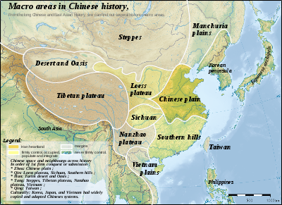 Chinese history is often explained in terms of several strategic areas, definite by particular topographic limits. Starting from the Chinese central plain
, the former heart of the Han populations, the Han people expanded militarily and then demographically toward the Loess plateau
, the Sichuan plain
, and the Southern hills, not without resistance from local populations. Pushed by its comparatively higher demographic growth, the Han continued their expansion by military and demographic waves. The far-south of nowadays China, the northern parts of today's Vietnam, the Tarim basin
were first reached and durably subdued by the Han dynasty
's armies. The Northern steppes were always the source of invasions into China, which culminated in the XIIIth century by Mongolian conquest of the whole China and creation of Mongolian Yuan dynasty. The Manchurian plain
and Korean peninsula
were usually not under Chinese control, with the exception of some limited periods of occupation. The Manchurian plain became strongly integrated into the Chinese empire during the late Qing dynasty
, while the West side of the Changbai mountains
, formerly the home of Korean tribes, thus also entered China.
Later 19th and 20th centuries struggles led the Chinese Empire to collapse under westerners pressures, and the PRC to rise under its today shape.
s, the Palearctic
and the Indomalaya
. In the Palearctic zone are found such important mammals as the horse
, camel
, tapir
, and jerboa
. Among the species found in the Indomalaya region are the Leopard Cat
, bamboo rat
, treeshrew
, and various other species of monkeys and apes. Some overlap exists between the two regions because of natural dispersal and migration, and deer or antelope, bears, wolves, pigs, and rodents are found in all of the diverse climatic and geological environments. The famous giant panda
is found only in a limited area along the Chang Jiang. There is a continuing problem with trade in endangered species
, although there are now laws to prohibit such activities.
 China's borders have more than 20,000 km of land frontier shared with nearly all the nations of mainland East Asia
, were disputed at a number of points. In the western sector, China claimed portions of the 41,000 km² Pamir Mountains
area, a region of soaring mountain peaks and glacial valleys where the borders of Afghanistan
, Pakistan
, the Soviet Union
, and China meet in Central Asia
. North and east of this region, some sections of the border remained undemarcated in 1987. The 6,542 km frontier with the Soviet Union has been a source of continual friction. In 1954 China published maps showing substantial portions of Soviet Siberian territory as its own. In the northeast, border friction with the Soviet Union produced a tense situation in remote regions of Inner Mongolia
and Heilongjiang
along segments of the Argun River
, Amur River, and Ussuri River
. Each side had massed troops and had exchanged charges of border provocation in this area. In a September 1986 speech in Vladivostok
, Soviet leader Mikhail S. Gorbachev offered the Chinese a more conciliatory position on Sino-Soviet border rivers. In 1987 the two sides resumed border talks that had been broken off after the 1979 Soviet invasion of Afghanistan (see Sino-Soviet relations
). Although the border issue remained unresolved as of late 1987, China and the Soviet Union agreed to consider the northeastern sector first. In October 2004, China signed an agreement with Russia
on the delimitation of their entire 4,300-kilometer-long border, which had long been in dispute.
A major dispute between China and India focuses on the northern edge of their shared border, where the Aksai Chin
area of northeastern Jammu
and Kashmir
is under Chinese de facto
administration but claimed by India
and Pakistan
. Eastward from Bhutan
and north of the Brahmaputra River
(Yarlung Zangbo Jiang) lies a large area controlled and administered by India but claimed by the Chinese. The area was demarcated by the British McMahon Line
, drawn along the Himalayas
in 1914 as the Sino-Indian border; India accepts and China rejects this boundary. In June 1980 China made its first move in twenty years to settle the border disputes with India, proposing that India cede the Aksai Chin area in Jammu and Kashmir to China in return for China's recognition of the McMahon Line; India did not accept the offer, however, preferring a sector-by-sector approach to the problem. In July 1986 China and India held their seventh round of border talks, but they made little headway toward resolving the dispute. Each side, but primarily India, continued to make allegations of incursions into its territory by the other. Most of the mountainous and militarized boundary with India is still in dispute, but Beijing
and New Delhi
have committed to begin resolution with discussions on the least disputed middle sector. India does not recognize Pakistan’s ceding lands to China in a 1964 boundary agreement.
The China-Burma border issue was settled October 1, 1960, by the signing of the Sino-Burmese Boundary Treaty. The first joint inspection of the border was completed successfully in June 1986.
China is involved in a complex dispute with Malaysia, Philippines
, Vietnam
, and possibly Brunei
over the Spratly (Nansha) Islands in the South China Sea. The 2002 "Declaration on the Conduct of Parties in the South China Sea" eased tensions but fell short of a legally binding code of conduct
desired by several of the disputants. China also occupies the Paracel (Xisha) Islands, which are also claimed by Vietnam, and asserts a claim to the Japan
ese-administered Senkaku Islands
(Diaoyu Tai) in the Pacific Ocean
.
to Argentina and Chile. Taiwan is antipodal to Paraguay. Wuhai
, for example, is antipodal to Valdivia
, Chile. See Geography of Chile#Antipodes, Geography of Argentina#Antipodes, and Geography of Paraguay#Antipodes for details.
East Asia
East Asia or Eastern Asia is a subregion of Asia that can be defined in either geographical or cultural terms...
n landmass bordering the East China Sea
East China Sea
The East China Sea is a marginal sea east of China. It is a part of the Pacific Ocean and covers an area of 1,249,000 km² or 750,000 square miles.-Geography:...
, Korea Bay
Korea Bay
The Korea Bay is a northern extension of the Yellow Sea, between Liaoning Province of China and North P'yŏngan Province of North Korea.It is separated from the Bohai Sea by the Liaodong Peninsula, with Dalian at its southernmost point...
, Yellow Sea
Yellow Sea
The Yellow Sea is the name given to the northern part of the East China Sea, which is a marginal sea of the Pacific Ocean. It is located between mainland China and the Korean Peninsula. Its name comes from the sand particles from Gobi Desert sand storms that turn the surface of the water golden...
, and South China Sea
South China Sea
The South China Sea is a marginal sea that is part of the Pacific Ocean, encompassing an area from the Singapore and Malacca Straits to the Strait of Taiwan of around...
, between North Korea
North Korea
The Democratic People’s Republic of Korea , , is a country in East Asia, occupying the northern half of the Korean Peninsula. Its capital and largest city is Pyongyang. The Korean Demilitarized Zone serves as the buffer zone between North Korea and South Korea...
and Vietnam
Vietnam
Vietnam – sometimes spelled Viet Nam , officially the Socialist Republic of Vietnam – is the easternmost country on the Indochina Peninsula in Southeast Asia. It is bordered by China to the north, Laos to the northwest, Cambodia to the southwest, and the South China Sea –...
in a changing configuration of broad plains, expansive desert
Desert
A desert is a landscape or region that receives an extremely low amount of precipitation, less than enough to support growth of most plants. Most deserts have an average annual precipitation of less than...
s, and lofty mountain range
Mountain range
A mountain range is a single, large mass consisting of a succession of mountains or narrowly spaced mountain ridges, with or without peaks, closely related in position, direction, formation, and age; a component part of a mountain system or of a mountain chain...
s, including vast areas of inhospitable terrain. The eastern half of the country, its seacoast fringed with offshore islands, is a region of fertile lowlands, foothills and mountains, desert
Desert
A desert is a landscape or region that receives an extremely low amount of precipitation, less than enough to support growth of most plants. Most deserts have an average annual precipitation of less than...
s, steppe
Steppe
In physical geography, steppe is an ecoregion, in the montane grasslands and shrublands and temperate grasslands, savannas, and shrublands biomes, characterized by grassland plains without trees apart from those near rivers and lakes...
s, and subtropical areas. The western half of China is a region of sunken basin
Drainage basin
A drainage basin is an extent or an area of land where surface water from rain and melting snow or ice converges to a single point, usually the exit of the basin, where the waters join another waterbody, such as a river, lake, reservoir, estuary, wetland, sea, or ocean...
s, rolling plateau
Plateau
In geology and earth science, a plateau , also called a high plain or tableland, is an area of highland, usually consisting of relatively flat terrain. A highly eroded plateau is called a dissected plateau...
s, and towering massif
Massif
In geology, a massif is a section of a planet's crust that is demarcated by faults or flexures. In the movement of the crust, a massif tends to retain its internal structure while being displaced as a whole...
s, including a portion of the highest tableland on earth.
In spite of many good harbors along the approximately 18,000-kilometer coastline, the nation has traditionally oriented itself not toward the sea but inland, developing as an imperial power whose center lay in the middle and lower reaches of the Yellow River
Yellow River
The Yellow River or Huang He, formerly known as the Hwang Ho, is the second-longest river in China and the sixth-longest in the world at the estimated length of . Originating in the Bayan Har Mountains in Qinghai Province in western China, it flows through nine provinces of China and empties into...
on the northern plains. China also has the Tibetan Plateau
Tibetan Plateau
The Tibetan Plateau , also known as the Qinghai–Tibetan Plateau is a vast, elevated plateau in Central Asia covering most of the Tibet Autonomous Region and Qinghai, in addition to smaller portions of western Sichuan, southwestern Gansu, and northern Yunnan in Western China and Ladakh in...
, a very large, high altitude plateau, to the south. To the north of the Tibetan Plateau lie the Gobi
Gobi Desert
The Gobi is a large desert region in Asia. It covers parts of northern and northwestern China, and of southern Mongolia. The desert basins of the Gobi are bounded by the Altai Mountains and the grasslands and steppes of Mongolia on the north, by the Hexi Corridor and Tibetan Plateau to the...
and Taklamakan
Taklamakan
The Taklamakan Desert , also known as Taklimakan and Teklimakan, is a desert in Central Asia, in the Xinjiang Uyghur Autonomous Region of the People's Republic of China...
deserts, which stretch from the extreme northwest eastward through Mongolia
Mongolia
Mongolia is a landlocked country in East and Central Asia. It is bordered by Russia to the north and China to the south, east and west. Although Mongolia does not share a border with Kazakhstan, its western-most point is only from Kazakhstan's eastern tip. Ulan Bator, the capital and largest...
.
The People's Republic of China is one of the world's largest countries in total area behind Russia
Russia
Russia or , officially known as both Russia and the Russian Federation , is a country in northern Eurasia. It is a federal semi-presidential republic, comprising 83 federal subjects...
and Canada
Canada
Canada is a North American country consisting of ten provinces and three territories. Located in the northern part of the continent, it extends from the Atlantic Ocean in the east to the Pacific Ocean in the west, and northward into the Arctic Ocean...
, and very similar to the United States
United States
The United States of America is a federal constitutional republic comprising fifty states and a federal district...
. Figures for the size of China differ slightly depending on where one draws a number of ill-defined boundaries, including claims by the PRC on territories such as Taiwan
Political status of Taiwan
The controversy regarding the political status of Taiwan hinges on whether Taiwan, Penghu, Kinmen, and Matsu should remain effectively independent as territory of the Republic of China , become unified with the territories now governed by the People's Republic of China , or formally declare...
, Aksai Chin
Aksai Chin
Aksai Chin is one of the two main disputed border areas between China and India, and the other is South Tibet, which comprises most of India's Arunachal Pradesh. It is administered by China as part of Hotan County in the Hotan Prefecture of Xinjiang Autonomous Region, but is also claimed by India...
, Trans-Karakoram Tract
Trans-Karakoram Tract
The Trans-Karakoram Tract is an area of nearly along both sides of the Shaksgam River, is entirely administered by the People's Republic of China as a part of Kargilik County and Taxkorgan Tajik Autonomous County in the Kashgar Prefecture of Xinjiang Autonomous Region, but claimed by Pakistan...
, and South Tibet
South Tibet
The Arunachal Pradesh dispute is a territorial dispute over the region located on the middle of the Yarlung Zangbo River, 300 km north of the Himalayas. It is entirely administered by India as part of its Arunachal Pradesh state; China claims it as a part of its Tibet Autonomous Region and...
. The official figure by the People's Republic of China
People's Republic of China
China , officially the People's Republic of China , is the most populous country in the world, with over 1.3 billion citizens. Located in East Asia, the country covers approximately 9.6 million square kilometres...
is 9.6 million square kilometers. The Republic of China
Republic of China
The Republic of China , commonly known as Taiwan , is a unitary sovereign state located in East Asia. Originally based in mainland China, the Republic of China currently governs the island of Taiwan , which forms over 99% of its current territory, as well as Penghu, Kinmen, Matsu and other minor...
based in Taiwan
Taiwan
Taiwan , also known, especially in the past, as Formosa , is the largest island of the same-named island group of East Asia in the western Pacific Ocean and located off the southeastern coast of mainland China. The island forms over 99% of the current territory of the Republic of China following...
but claiming to be the government of China puts this figure at 11 million square kilometres, but this includes Mongolia
Mongolia
Mongolia is a landlocked country in East and Central Asia. It is bordered by Russia to the north and China to the south, east and west. Although Mongolia does not share a border with Kazakhstan, its western-most point is only from Kazakhstan's eastern tip. Ulan Bator, the capital and largest...
, a state whose sovereignty has been recognized by the PRC. China's contour is reasonably comparable to that of the United States and lies largely at the same latitudes. The total area is estimated to be 9,758,801 km2, with land accounting for 9,326,410 km2 and water for 270,550 km2 (around 3 percent).
Geography
Tibetan Plateau
The Tibetan Plateau , also known as the Qinghai–Tibetan Plateau is a vast, elevated plateau in Central Asia covering most of the Tibet Autonomous Region and Qinghai, in addition to smaller portions of western Sichuan, southwestern Gansu, and northern Yunnan in Western China and Ladakh in...
and other less-elevated highlands rise rugged east-west trending mountains, and plateaus interrupted by deep depressions fanning out to the north and east. The Tibetan Plateau is a vast , elevated plateau
Plateau
In geology and earth science, a plateau , also called a high plain or tableland, is an area of highland, usually consisting of relatively flat terrain. A highly eroded plateau is called a dissected plateau...
covering most of the Tibet Autonomous Region
Tibet Autonomous Region
The Tibet Autonomous Region , Tibet or Xizang for short, also called the Xizang Autonomous Region is a province-level autonomous region of the People's Republic of China , created in 1965....
and Qinghai Province in the People's Republic of China
People's Republic of China
China , officially the People's Republic of China , is the most populous country in the world, with over 1.3 billion citizens. Located in East Asia, the country covers approximately 9.6 million square kilometres...
and Ladakh
Ladakh
Ladakh is a region of Jammu and Kashmir, the northernmost state of the Republic of India. It lies between the Kunlun mountain range in the north and the main Great Himalayas to the south, inhabited by people of Indo-Aryan and Tibetan descent...
in India
India
India , officially the Republic of India , is a country in South Asia. It is the seventh-largest country by geographical area, the second-most populous country with over 1.2 billion people, and the most populous democracy in the world...
. With an average elevation of over 4,500 meters, it is the highest and biggest plateau
Plateau
In geology and earth science, a plateau , also called a high plain or tableland, is an area of highland, usually consisting of relatively flat terrain. A highly eroded plateau is called a dissected plateau...
in the world and an area of 2.5 million square kilometers. A continental scarp
Escarpment
An escarpment is a steep slope or long cliff that occurs from erosion or faulting and separates two relatively level areas of differing elevations.-Description and variants:...
marks the eastern margin of this territory, a scarp thaht extends from the Greater Khingan Range in northeastern China, through the Taihang Mountains
Taihang Mountains
The Taihang Mountains are a Chinese mountain range running down the eastern edge of the Loess Plateau in Henan, Shanxi and Hebei provinces. The range extends over 400 km from north to south and has an average elevation of 1,500 to 2,000 meters. The principal peak is Xiao Wutaishan...
(a range of mountains overlooking the North China Plain
North China Plain
The North China Plain is based on the deposits of the Yellow River and is the largest alluvial plain of eastern Asia. The plain is bordered on the north by the Yanshan Mountains and on the west by the Taihang Mountains edge of the Shanxi plateau. To the south, it merges into the Yangtze Plain...
) to the eastern edge of the Yunnan-Guizhou Plateau in the south. All of the low-lying areas of China, which support dense population and intensive cultivation, are to the east of this scarp line.
The east-west ranges include some of Asia's greatest mountains. In addition to the Himalayas
Himalayas
The Himalaya Range or Himalaya Mountains Sanskrit: Devanagari: हिमालय, literally "abode of snow"), usually called the Himalayas or Himalaya for short, is a mountain range in Asia, separating the Indian subcontinent from the Tibetan Plateau...
and the Kunlun Mountains
Kunlun Mountains
The Kunlun Mountains are one of the longest mountain chains in Asia, extending more than 3,000 km. In the broadest sense, it forms the northern edge of the Tibetan Plateau south of the Tarim Basin and the Gansu Corridor and continues east south of the Wei River to end at the North China Plain.The...
, there are the Mount Kailash
Mount Kailash
Mount Kailash is a peak in the Gangdisê Mountains, which are part of the Himalayas in Tibet...
(Gangdise) and the Tian Shan
Tian Shan
The Tian Shan , also spelled Tien Shan, is a large mountain system located in Central Asia. The highest peak in the Tian Shan is Victory Peak , ....
ranges. The latter stands between two great basins, the massive Tarim Basin
Tarim Basin
The Tarim Basin is a large endorheic basin occupying an area of about . It is located in the Xinjiang Uyghur Autonomous Region in China's far west. Its northern boundary is the Tian Shan mountain range and its southern is the Kunlun Mountains on the northern edge of the Tibetan Plateau. The...
to the south and the Dzungarian Basin to the north. Rich deposits of coal, oil, and metallic ores lie in the Tian Shan area. The largest inland basin in China, the Tarim Basin measures 1,500 kilometers from east to west and 600 kilometers from north to south at its widest parts. The Himalayas form a natural boundary on the southwest as the Altai Mountains do on the northwest. Lesser ranges branch out, some at sharp angles from the major ranges. The mountains give rise to all the principal rivers. The spine of the Kunlun Mountains
Kunlun Mountains
The Kunlun Mountains are one of the longest mountain chains in Asia, extending more than 3,000 km. In the broadest sense, it forms the northern edge of the Tibetan Plateau south of the Tarim Basin and the Gansu Corridor and continues east south of the Wei River to end at the North China Plain.The...
separates into several branches as it runs eastward from the Pamir Mountains
Pamir Mountains
The Pamir Mountains are a mountain range in Central Asia formed by the junction or knot of the Himalayas, Tian Shan, Karakoram, Kunlun, and Hindu Kush ranges. They are among the world’s highest mountains and since Victorian times they have been known as the "Roof of the World" a probable...
. The northernmost branches, the Altyn-Tagh
Altyn-Tagh
Altyn-Tagh, Astyn-Tagh, Altun Mountains, Altun Shan or Aerjin Shan Tagh proper is a part of the range south of Lop Nor), is a mountain range in northwestern China that separates the eastern Tarim Basin from the Tibetan Plateau...
and the Qilian Range, form the rim of the Tibetan Plateau in west-central China and overlook the Qaidam
Qaidam
Qaidam Basin, also spelled Tsaidam is an hyperarid basin that occupies a large part of the Haixi Mongol and Tibetan Autonomous Prefecture in Qinghai Province, western China...
Basin, a sandy and swamp
Swamp
A swamp is a wetland with some flooding of large areas of land by shallow bodies of water. A swamp generally has a large number of hammocks, or dry-land protrusions, covered by aquatic vegetation, or vegetation that tolerates periodical inundation. The two main types of swamp are "true" or swamp...
y region containing many salt lakes. A southern branch of the Kunlun Mountains divides the watershed
Drainage basin
A drainage basin is an extent or an area of land where surface water from rain and melting snow or ice converges to a single point, usually the exit of the basin, where the waters join another waterbody, such as a river, lake, reservoir, estuary, wetland, sea, or ocean...
s of the Yellow River
Yellow River
The Yellow River or Huang He, formerly known as the Hwang Ho, is the second-longest river in China and the sixth-longest in the world at the estimated length of . Originating in the Bayan Har Mountains in Qinghai Province in western China, it flows through nine provinces of China and empties into...
(Huang He) and the Yangtze River
Yangtze River
The Yangtze, Yangzi or Cháng Jiāng is the longest river in Asia, and the third-longest in the world. It flows for from the glaciers on the Tibetan Plateau in Qinghai eastward across southwest, central and eastern China before emptying into the East China Sea at Shanghai. It is also one of the...
(Chang Jiang). The Gansu Corridor, west of the great bend in the Yellow River, was traditionally an important communications link with Central Asia
Central Asia
Central Asia is a core region of the Asian continent from the Caspian Sea in the west, China in the east, Afghanistan in the south, and Russia in the north...
.
North of the 3,300-kilometer-long Great Wall, between Gansu
Gansu
' is a province located in the northwest of the People's Republic of China.It lies between the Tibetan and Huangtu plateaus, and borders Mongolia, Inner Mongolia, and Ningxia to the north, Xinjiang and Qinghai to the west, Sichuan to the south, and Shaanxi to the east...
Province on the west and the Greater Khingan Range on the east, lies the Mongolian Plateau
Mongolian Plateau
The Mongolian Plateau is part of the larger Central Asian Plateau and has an area of approximately 2,600,000 square kilometres. It is occupied by Mongolia in the north and Inner Mongolia in the south. The plateau includes the Gobi Desert as well as dry steppe regions...
, at an average elevation of 1,000 metres above sea level. The Yin Mountains
Yin Mountains
The Yin Mountains are mountains in the steppe forming the southern border of the eastern Gobi Desert of the Inner Mongolia Autonomous Region, as well as the northern part of Hebei province....
, a system of mountains with average elevations of 1,400 metres, extends east-west through the center of this vast desert steppe
Steppe
In physical geography, steppe is an ecoregion, in the montane grasslands and shrublands and temperate grasslands, savannas, and shrublands biomes, characterized by grassland plains without trees apart from those near rivers and lakes...
. To the south is the largest loess plateau
Loess Plateau
The Loess Plateau , also known as the Huangtu Plateau, is a plateau that covers an area of some 640,000 km² in the upper and middle reaches of China's Yellow River. Loess is the name for the silty sediment that has been deposited by wind storms on the plateau over the ages...
in the world, covering 600,000 square kilometers in Shaanxi
Shaanxi
' is a province in the central part of Mainland China, and it includes portions of the Loess Plateau on the middle reaches of the Yellow River in addition to the Qinling Mountains across the southern part of this province...
Province, parts of Gansu and Shanxi provinces, and some of Ningxia-Hui Autonomous Region. Loess
Loess
Loess is an aeolian sediment formed by the accumulation of wind-blown silt, typically in the 20–50 micrometre size range, twenty percent or less clay and the balance equal parts sand and silt that are loosely cemented by calcium carbonate...
is a yellowish soil blown in from the Inner Mongolian deserts. The loose, loamy material travels easily in the wind, and through the centuries it has veneered the plateau and choked the Yellow River with silt. Because the river level drops precipitously toward the North China Plain where it sluggishly crosses the delta, it carries a heavy load of sediment
Sediment
Sediment is naturally occurring material that is broken down by processes of weathering and erosion, and is subsequently transported by the action of fluids such as wind, water, or ice, and/or by the force of gravity acting on the particle itself....
in the form of sand and mud from the upper reaches, much of which is deposited on the flat plain. The flow is controlled mainly by constantly repaired man-made embankments while floods and course changes have recurred over the centuries. As a result the river flows on a raised ridge fifty meters or more above the plain, Traditionally, rulers were judged by their concern for or indifference to preservation of the embankments.
The Paleozoic
Paleozoic
The Paleozoic era is the earliest of three geologic eras of the Phanerozoic eon, spanning from roughly...
formations of China, excepting only the upper part of the Carboniferous
Carboniferous
The Carboniferous is a geologic period and system that extends from the end of the Devonian Period, about 359.2 ± 2.5 Mya , to the beginning of the Permian Period, about 299.0 ± 0.8 Mya . The name is derived from the Latin word for coal, carbo. Carboniferous means "coal-bearing"...
system, are marine, while the Mesozoic
Mesozoic
The Mesozoic era is an interval of geological time from about 250 million years ago to about 65 million years ago. It is often referred to as the age of reptiles because reptiles, namely dinosaurs, were the dominant terrestrial and marine vertebrates of the time...
and Tertiary
Tertiary
The Tertiary is a deprecated term for a geologic period 65 million to 2.6 million years ago. The Tertiary covered the time span between the superseded Secondary period and the Quaternary...
deposits are estuarine and freshwater, or else of terrestrial origin. Groups of volcanic cones occur in the Great Plain of north China. In the Liaodong and Shandong
Shandong
' is a Province located on the eastern coast of the People's Republic of China. Shandong has played a major role in Chinese history from the beginning of Chinese civilization along the lower reaches of the Yellow River and served as a pivotal cultural and religious site for Taoism, Chinese...
Peninsulas, there are basalt
Basalt
Basalt is a common extrusive volcanic rock. It is usually grey to black and fine-grained due to rapid cooling of lava at the surface of a planet. It may be porphyritic containing larger crystals in a fine matrix, or vesicular, or frothy scoria. Unweathered basalt is black or grey...
ic plateaus.
Flowing from its source in the Tibetan highlands, the Yellow River courses toward the sea through the North China Plain
North China Plain
The North China Plain is based on the deposits of the Yellow River and is the largest alluvial plain of eastern Asia. The plain is bordered on the north by the Yanshan Mountains and on the west by the Taihang Mountains edge of the Shanxi plateau. To the south, it merges into the Yangtze Plain...
, the historic center of Chinese expansion and influence. Han Chinese
Han Chinese
Han Chinese are an ethnic group native to China and are the largest single ethnic group in the world.Han Chinese constitute about 92% of the population of the People's Republic of China , 98% of the population of the Republic of China , 78% of the population of Singapore, and about 20% of the...
people have farmed the rich alluvial soils of the plain since ancient times, constructing the Grand Canal of China
Grand Canal of China
The Grand Canal in China, also known as the Beijing-Hangzhou Grand Canal is the longest canal or artificial river in the world. Starting at Beijing, it passes through Tianjin and the provinces of Hebei, Shandong, Jiangsu and Zhejiang to the city of Hangzhou...
for north-south transport. The plain itself is actually a continuation of the Northeast China Plain
Northeast China Plain
The Northeast China Plain , also known as the Manchurian Plain, is located in Northeast China. It lies between the Greater and Lesser Khinggan and Changbai mountains. Covering 350,000 km2, it is China's largest plain, with an elevation of lower than 200 meters...
to the northeast but is separated from it by the Bohai Gulf, an extension of the Yellow Sea
Yellow Sea
The Yellow Sea is the name given to the northern part of the East China Sea, which is a marginal sea of the Pacific Ocean. It is located between mainland China and the Korean Peninsula. Its name comes from the sand particles from Gobi Desert sand storms that turn the surface of the water golden...
. Like other densely populated areas of China, the plain is subject not only to floods but to earthquakes. For example, the mining and industrial center of Tangshan
Tangshan
"唐山"redirects here. For an alternative name of China, see Names of China#TangTangshan is a largely industrial prefecture-level city in Hebei province, People's Republic of China. It has become known for the 1976 Tangshan earthquake which measured 7.8 on the Richter scale and killed at least...
, about 165 kilometers east of Beijing
Beijing
Beijing , also known as Peking , is the capital of the People's Republic of China and one of the most populous cities in the world, with a population of 19,612,368 as of 2010. The city is the country's political, cultural, and educational center, and home to the headquarters for most of China's...
, was leveled by an earthquake in July 1976 that reportedly also killed 242,000 people and injured 164,000.
The Qinling mountain range, a continuation of the Kunlun Mountains, divides the North China Plain from the Yangtze River Delta
Yangtze River Delta
The Yangtze River Delta, Yangtze Delta or YRD, also called Yangzi, or Chang Jiang Delta, Rive Chang Delta Tai Lake Region or the Golden Triangle of the Yangtze, generally comprises the triangular-shaped territory of Wu-speaking Shanghai, southern Jiangsu province and northern Zhejiang province of...
and is the major physiographic boundary between the two great parts of China Proper
China proper
China proper or Eighteen Provinces was a term used by Western writers on the Qing Dynasty to express a distinction between the core and frontier regions of China. There is no fixed extent for China proper, as many administrative, cultural, and linguistic shifts have occurred in Chinese history...
. It is in a sense a cultural boundary as well, influencing the distribution of custom and language. South of the Qinling divide are the densely populated and highly developed areas of the lower and middle plains of the Yangtze and, on its upper reaches, the Sichuan Basin
Sichuan basin
The Sichuan Basin is a lowland region in southwestern China. Despite its historical name, it is not only synonymous to Sichuan province, comprising its central and eastern portions as well as part of Chongqing Municipality...
, an area encircled by a high barrier of mountain ranges. The country's longest and most important waterway, the Yangtze River is navigable over much of its length and is now the site of the Three Gorges Dam
Three Gorges Dam
The Three Gorges Dam is a hydroelectric dam that spans the Yangtze River by the town of Sandouping, located in the Yiling District of Yichang, in Hubei province, China...
. Rising on the Tibetan Plateau, the Yangtze River traverses 6,300 kilometers through the heart of the country, draining an area of 1.8 million square kilometers before emptying into the East China Sea
East China Sea
The East China Sea is a marginal sea east of China. It is a part of the Pacific Ocean and covers an area of 1,249,000 km² or 750,000 square miles.-Geography:...
. The Sichuan Basin, favored by a mild, humid climate and a long growing season, produces a rich variety of crops; it is also a leading silk-producing area and an important industrial region with substantial mineral resources.
Second only to the Qinling as an internal boundary is the Nanling, the southernmost of the east-west mountain ranges. The Nanling overlooks the part of China where a tropical climate permits two crops of rice to be grown each year. Southeast of the mountains lies a coastal, hilly region of small deltas and narrow valley plains; the drainage area of the Pearl River
Pearl River (China)
The Pearl River or less commonly, the "Guangdong River" or "Canton River" etc., , is an extensive river system in southern China. The name Pearl River is usually used as a catchment term to refer to the watersheds of the Xi Jiang , the Bei Jiang , and the Dong Jiang...
(Zhu Jiang) and its associated network of rivers occupies much of the region to the south. West of the Nanling, the Yunnan-Guizhou Plateau rises in two steps, averaging 1,200 and 1,800 meters in elevation, respectively, toward the precipitous mountain regions of the eastern Tibetan Plateau.
The Hai River
Hai River
The Hai River , previously called Bai He , is a river in the People's Republic of China which flows through Beijing and Tianjin before emptying into the Yellow Sea at the Bohai Gulf.The Hai River at Tianjin is formed by the confluence of five rivers, the Southern Canal, Ziya...
, like the Pearl and other major waterways, flows from west to east. Its upper course consists of five rivers that converge near Tianjin
Tianjin
' is a metropolis in northern China and one of the five national central cities of the People's Republic of China. It is governed as a direct-controlled municipality, one of four such designations, and is, thus, under direct administration of the central government...
, then flow seventy kilometers before emptying into the Bohai Gulf. Another major river, the Huai
Huai River
The Huai River is a major river in China. The Huai River is located about mid-way between the Yellow River and Yangtze River, the two largest rivers in China, and like them runs from west to east...
, rises in Henan
Henan
Henan , is a province of the People's Republic of China, located in the central part of the country. Its one-character abbreviation is "豫" , named after Yuzhou , a Han Dynasty state that included parts of Henan...
Province and flows through several lakes before joining the Yangtze near Yangzhou
Yangzhou
Yangzhou is a prefecture-level city in central Jiangsu Province, People's Republic of China. Sitting on the northern bank of the Yangtze River, it borders the provincial capital of Nanjing to the southwest, Huai'an to the north, Yancheng to the northeast, Taizhou to the east, and Zhenjiang across...
. Inland drainage involving a number of upland basins in the north and northeast accounts for about 40 percent of the country's total drainage area. Many rivers and streams flow into lakes or diminish in the desert. Some are useful for irrigation.
China's extensive territorial waters are principally marginal seas of the western Pacific Ocean
Pacific Ocean
The Pacific Ocean is the largest of the Earth's oceanic divisions. It extends from the Arctic in the north to the Southern Ocean in the south, bounded by Asia and Australia in the west, and the Americas in the east.At 165.2 million square kilometres in area, this largest division of the World...
; these waters wash the shores of a long and much-indented coastline and approximately 5,000 islands. The Yellow, East China, and South China seas, too, are marginal seas of the Pacific Ocean. More than half the coastline (predominantly in the south) is rocky; most of the remainder is sandy. Hangzhou Bay
Hangzhou Bay
Hangzhou Bay, or the Bay of Hangzhou , is an inlet of the East China Sea, bordered by the province of Zhejiang and the municipality of Shanghai. The Qiantang River flows into the bay.It lies south of Shanghai, and ends at the city of Hangzhou...
roughly divides the two kinds of shoreline.
Areas of China have experienced earthquakes. On 23 August 1976, a major earthquake in Tangshan
1976 Tangshan earthquake
The Tangshan Earthquake also known as the Great Tangshan Earthquake, was a natural disaster that occurred on July 28, 1976. It is believed to be the largest earthquake of the 20th century by death toll. The epicenter of the earthquake was near Tangshan in Hebei, People's Republic of China, an...
killed hundreds of thousands of people. However, most regions of China do not experience earthquakes, as major population centers are a long distance from fault lines
Fault Lines
Fault Lines, a documentary series produced and broadcasted by Al Jazeera English, is the channel's flagship program about the Americas.Josh Rushing, Zeina Awad and Sebastian Walker host the series, currently enjoying it's third season....
. Tangshan
Tangshan
"唐山"redirects here. For an alternative name of China, see Names of China#TangTangshan is a largely industrial prefecture-level city in Hebei province, People's Republic of China. It has become known for the 1976 Tangshan earthquake which measured 7.8 on the Richter scale and killed at least...
is one of the few places in China that is located within an earthquake zone. There are few volcano
Volcano
2. Bedrock3. Conduit 4. Base5. Sill6. Dike7. Layers of ash emitted by the volcano8. Flank| 9. Layers of lava emitted by the volcano10. Throat11. Parasitic cone12. Lava flow13. Vent14. Crater15...
es in China
China
Chinese civilization may refer to:* China for more general discussion of the country.* Chinese culture* Greater China, the transnational community of ethnic Chinese.* History of China* Sinosphere, the area historically affected by Chinese culture...
.
Topography
Topography
Topography is the study of Earth's surface shape and features or those ofplanets, moons, and asteroids...
of China is diverse with snow-capped mountains, deep river valleys, broad basins, high plateaus, rolling plains, terraced hills, sandy dunes, craggy karsts, volcanic calderas, low-latitude glaciers and other landforms present in myriad variations. In general, the land is high in the west and descends to the east coast. Mountains (33%), plateaus (26%) and hills (10%) account for nearly 70% of the country's land surface. Most of the country's arable land and population are based in lowland plains (12%) and basins (19%), though some of the greatest basins are filled with deserts. The country's rugged terrain presents problems for the construction of overland transportation infrastructure
Transportation in the People's Republic of China
Transport in the People's Republic of China has experienced major growth and expansion in recent years. Airports, roads, and railway construction will provide a massive employment boost in China over the next decade....
and requires extensive terracing to sustain agriculture
Agriculture in China
Agriculture is an important economic sector of China, employing over 300 million farmers. China ranks first in worldwide farm output, primarily producing rice, wheat, potatoes, sorghum, peanuts, tea, millet, barley, cotton, oilseed, pork, and fish.-History:...
, but are conducive to the development of forestry
Forestry
Forestry is the interdisciplinary profession embracing the science, art, and craft of creating, managing, using, and conserving forests and associated resources in a sustainable manner to meet desired goals, needs, and values for human benefit. Forestry is practiced in plantations and natural stands...
, mineral
Mineral
A mineral is a naturally occurring solid chemical substance formed through biogeochemical processes, having characteristic chemical composition, highly ordered atomic structure, and specific physical properties. By comparison, a rock is an aggregate of minerals and/or mineraloids and does not...
and hydropower
Hydropower
Hydropower, hydraulic power, hydrokinetic power or water power is power that is derived from the force or energy of falling water, which may be harnessed for useful purposes. Since ancient times, hydropower has been used for irrigation and the operation of various mechanical devices, such as...
resources and tourism
Tourism in China
Tourism in China has greatly expanded over the last few decades since the beginning of reform and opening. The emergence of a newly rich middle class and an easing of restrictions on movement by the Chinese authorities are both fueling this travel boom. China has become one of the world's...
.
The world's tallest mountains, the Himalayas
Himalayas
The Himalaya Range or Himalaya Mountains Sanskrit: Devanagari: हिमालय, literally "abode of snow"), usually called the Himalayas or Himalaya for short, is a mountain range in Asia, separating the Indian subcontinent from the Tibetan Plateau...
, Karakorum
Karakorum
Karakorum was the capital of the Mongol Empire in the 13th century, and of the Northern Yuan in the 14-15th century. Its ruins lie in the northwestern corner of the Övörkhangai Province of Mongolia, near today's town of Kharkhorin, and adjacent to the Erdene Zuu monastery...
, Pamirs and Tian Shan
Tian Shan
The Tian Shan , also spelled Tien Shan, is a large mountain system located in Central Asia. The highest peak in the Tian Shan is Victory Peak , ....
divide China from South
South Asia
South Asia, also known as Southern Asia, is the southern region of the Asian continent, which comprises the sub-Himalayan countries and, for some authorities , also includes the adjoining countries to the west and the east...
and Central Asia
Central Asia
Central Asia is a core region of the Asian continent from the Caspian Sea in the west, China in the east, Afghanistan in the south, and Russia in the north...
. Eleven of the 17 tallest mountain peaks are located on China's western borders. They include world's tallest peak Mt. Everest (8848m) in the Himalyas on the border with Nepal and the world's second tallest peak, K2
K2
K2 is the second-highest mountain on Earth, after Mount Everest...
(8611m) on the border with Pakistan
Pakistan
Pakistan , officially the Islamic Republic of Pakistan is a sovereign state in South Asia. It has a coastline along the Arabian Sea and the Gulf of Oman in the south and is bordered by Afghanistan and Iran in the west, India in the east and China in the far northeast. In the north, Tajikistan...
. From these towering heights in the west, the land descends in steps like a terrace.
North of the Himalayas and east of the Karakorum/Pamirs is the vast Tibetan Plateau
Tibetan Plateau
The Tibetan Plateau , also known as the Qinghai–Tibetan Plateau is a vast, elevated plateau in Central Asia covering most of the Tibet Autonomous Region and Qinghai, in addition to smaller portions of western Sichuan, southwestern Gansu, and northern Yunnan in Western China and Ladakh in...
, the largest and highest plateau in the world, also known as the "Roof of the World." The plateau has an average elevation of 4,000m above sea level and covers an area of 2.5 million square kilometers, or about one-fifth of China's land mass. In the north, the plateau is hemmed in by the Kunlun Mountains
Kunlun Mountains
The Kunlun Mountains are one of the longest mountain chains in Asia, extending more than 3,000 km. In the broadest sense, it forms the northern edge of the Tibetan Plateau south of the Tarim Basin and the Gansu Corridor and continues east south of the Wei River to end at the North China Plain.The...
, which extends eastward from the intersection of the Pamirs, Karakorum and Tian Shan.
Northwest of the Tibetan Plateau, between the northern slope of Kunlun and southern slope of Tian Shan, is the vast Tarim Basin
Tarim Basin
The Tarim Basin is a large endorheic basin occupying an area of about . It is located in the Xinjiang Uyghur Autonomous Region in China's far west. Its northern boundary is the Tian Shan mountain range and its southern is the Kunlun Mountains on the northern edge of the Tibetan Plateau. The...
of Xinjiang
Xinjiang
Xinjiang is an autonomous region of the People's Republic of China. It is the largest Chinese administrative division and spans over 1.6 million km2...
, which contains the Taklamakan Desert. The Tarim Basin, the largest in China, measures 1,500 km from east to west and 600 km from north to south at its widest parts. Average elevation in the basin is 1,000m. To east, the basin descends into the Hami-Turpan Depression of eastern Xinjiang, where the dried lake bed of Lake Ayding at -154m below sea level, is the lowest surface point in China and the third lowest in the world. With temperatures that have reached 49.6 C, the lake bed ranks as one the hottest places in China. North of Tian Shan is Xinjiang's second great basin, the Jungar
Jungar
Jungar may refer to:*Dzungar people, sometimes spelled "Jungar" or "Jüün Ghar", the collective identity of several Oirat tribes*Jungar, Nepal, Village Development Committee in Nepal*Jungar Banner, county of Inner Mongolia, China...
, which contains the Gurbantünggüt Desert
Gurbantünggüt Desert
Gurbantünggüt Desert that occupies a large part of the Dzungarian Basin in northern Xinjiang, in the northwest of the People's Republic of China. It is approximately 50,000 square kilometers , and located around 300 to 600 meters above sea level...
. The Jungar Basin is enclosed to the north by the Altay Mountains
Altay Mountains
The Altai Mountains are a mountain range in East-Central Asia, where Russia, China, Mongolia and Kazakhstan come together, and where the rivers Irtysh and Ob have their sources. The Altai Mountains are known as the original locus of the speakers of Turkic as well as other members of the proposed...
which separates Xinjiang from Russia and Mongolia.
Northeast of the Tibetan Plateau, the Altun Shan-Qilian Mountains range branches off the Kunlun and creates a parallel mountain range running east-west. In between in northern Qinghai is the Qaidam Basin, with elevation of 2,600-3,000m and numerous brackish and salt lakes. North of the Qilian is Hexi Corridor
Hexi Corridor
Hexi Corridor or Gansu Corridor refers to the historical route in Gansu province of China. As part of the Northern Silk Road running northwest from the bank of the Yellow River, it was the most important route from North China to the Tarim Basin and Central Asia for traders and the military. The...
of Gansu, a natural passage between Xinjiang and China Proper
China proper
China proper or Eighteen Provinces was a term used by Western writers on the Qing Dynasty to express a distinction between the core and frontier regions of China. There is no fixed extent for China proper, as many administrative, cultural, and linguistic shifts have occurred in Chinese history...
that was part of the ancient Silk Road
Silk Road
The Silk Road or Silk Route refers to a historical network of interlinking trade routes across the Afro-Eurasian landmass that connected East, South, and Western Asia with the Mediterranean and European world, as well as parts of North and East Africa...
and traversed by modern highway and rail lines to Xinjiang. Further north, the Inner Mongolian Plateau
Mongolian Plateau
The Mongolian Plateau is part of the larger Central Asian Plateau and has an area of approximately 2,600,000 square kilometres. It is occupied by Mongolia in the north and Inner Mongolia in the south. The plateau includes the Gobi Desert as well as dry steppe regions...
, between 900-1,500m in elevation, arcs north up the spine of China and becomes the Greater Hinggan Range of Northeast China
Northeast China
Northeast China, historically known in English as Manchuria, is a geographical region of China, consisting of the three provinces of Liaoning, Jilin and Heilongjiang. The region is sometimes called the Three Northeast Provinces...
.
East of the Tibetan Plateau, deeply folded mountains fan out toward the Sichuan Basin
Sichuan basin
The Sichuan Basin is a lowland region in southwestern China. Despite its historical name, it is not only synonymous to Sichuan province, comprising its central and eastern portions as well as part of Chongqing Municipality...
, which is ringed by mountains in 1,000-3,000m elevation. The floor of the basin has an average elevation of 500m and is home to one of the most densely farmed and populated regions of China. The Sichuan Basin is capped in the north by the eastward continuation of the Kunlun range, the Qinling and Dabashan. The Qinling and Dabashan ranges form a major north-south divide across China Proper
China proper
China proper or Eighteen Provinces was a term used by Western writers on the Qing Dynasty to express a distinction between the core and frontier regions of China. There is no fixed extent for China proper, as many administrative, cultural, and linguistic shifts have occurred in Chinese history...
, the traditional core area of China. Southeast of the Tibetan Plateau and south of the Sichuan Basin is the Yunnan-Guizhou Plateau, which occupy much of southwest China. This plateau, with an average elevation of 2,000m, is known for limestone karst landscape.
Between the Qinling and the Inner Mongolian Plateau is Loess Plateau
Loess Plateau
The Loess Plateau , also known as the Huangtu Plateau, is a plateau that covers an area of some 640,000 km² in the upper and middle reaches of China's Yellow River. Loess is the name for the silty sediment that has been deposited by wind storms on the plateau over the ages...
, the largest of its kind in the world, covering 650,000 km² in Shaanxi
Shaanxi
' is a province in the central part of Mainland China, and it includes portions of the Loess Plateau on the middle reaches of the Yellow River in addition to the Qinling Mountains across the southern part of this province...
, parts of Gansu
Gansu
' is a province located in the northwest of the People's Republic of China.It lies between the Tibetan and Huangtu plateaus, and borders Mongolia, Inner Mongolia, and Ningxia to the north, Xinjiang and Qinghai to the west, Sichuan to the south, and Shaanxi to the east...
and Shanxi
Shanxi
' is a province in Northern China. Its one-character abbreviation is "晋" , after the state of Jin that existed here during the Spring and Autumn Period....
provinces, and some of Ningxia
Ningxia
Ningxia, formerly transliterated as Ningsia, is an autonomous region of the People's Republic of China. Located in Northwest China, on the Loess Plateau, the Yellow River flows through this vast area of land. The Great Wall of China runs along its northeastern boundary...
-Hui Autonomous Region. The plateau is 1,000-1,500m in elevation and is filled with loess, a yellowish, loose soil that travels easily in the wind. Eroded loess silt give the Yellow River
Yellow River
The Yellow River or Huang He, formerly known as the Hwang Ho, is the second-longest river in China and the sixth-longest in the world at the estimated length of . Originating in the Bayan Har Mountains in Qinghai Province in western China, it flows through nine provinces of China and empties into...
its color and name. The Loess Plateau is bound to the east by the Luliang Mountain of Shanxi, which has a narrow basin running north to south along the Fen River. Further east is the Taihang Mountains
Taihang Mountains
The Taihang Mountains are a Chinese mountain range running down the eastern edge of the Loess Plateau in Henan, Shanxi and Hebei provinces. The range extends over 400 km from north to south and has an average elevation of 1,500 to 2,000 meters. The principal peak is Xiao Wutaishan...
of Hebei, the dominant topographical feature of North China
North China
thumb|250px|Northern [[People's Republic of China]] region.Northern China or North China is a geographical region of China. The heartland of North China is the North China Plain....
.
The Taihang forms the western side of the triangular North China Plain
North China Plain
The North China Plain is based on the deposits of the Yellow River and is the largest alluvial plain of eastern Asia. The plain is bordered on the north by the Yanshan Mountains and on the west by the Taihang Mountains edge of the Shanxi plateau. To the south, it merges into the Yangtze Plain...
. The other two sides are the Pacific Coast to the east and the Yangtze River to the southwest. The vertices of this triangle are Beijing to the north, Shanghai to the southeast and Yichang to the southwest. This alluvial plain, fed by the Yellow and Yangtze Rivers, is one of the most heavily populated regions of China. The only mountains in the plain are the Taishan in Shandong and Dabie Mountains of Anhui.
South of the Yangtze, the landscape is more rugged. Like Shanxi Province to the north, each of Hunan
Hunan
' is a province of South-Central China, located to the south of the middle reaches of the Yangtze River and south of Lake Dongting...
and Jiangxi
Jiangxi
' is a southern province in the People's Republic of China. Spanning from the banks of the Yangtze River in the north into hillier areas in the south, it shares a border with Anhui to the north, Zhejiang to the northeast, Fujian to the east, Guangdong to the south, Hunan to the west, and Hubei to...
has a provincial core in a river basin that is surrounded by mountains. The Wuling range separates Guizhou from Hunan. The Luoxiao and Jinggang
Jinggangshan
Jinggangshan is located in the Luoxian Mountains , in the remote border region between Jiangxi and Hunan provinces of China. It lies at the junction of four counties - Ninggang, Yongxing, Suichuan and Lingxian. The mountains cover some 670 km², with an average elevation of 381.5 m above sea...
divides Hunan from Jiangxi, which is separated from Fujian by the Wuyi Mountains. The southeast coastal provinces, Zhejiang, Fujian and Guangdong have rugged coasts, with pockets of lowland and mountainous interior. The Nanling
Nanling
The Nanling are a group of mountain ranges of southern China, running through Guangxi Zhuang Autonomous Region, Guangdong province, and Hunan province....
, a east-west mountain range, across northern Guangdong, seals off Hunan and Jiangxi from Guangdong.
Beijing, situated at the north tip of the North China Plain, is shielded by the intersection of Taihang and Jingdu Mountains. Further north are the drier grasslands of the Inner Mongolian Plateau, traditionally home to pastoralists. To the south are agricultural regions, traditionally home to sedentary populations. The Great Wall of China was built in the mountains across the mountains that mark the southern edge of the Inner Mongolian Plateau. The Ming-era walls run 2,000 km east-to-west from Shanhaiguan on the Bohai Coast to the Hexi Corridor in Gansu. Northeast of Shanhaiguan, a narrow sliver of flat coastal land opens up into the vast Manchurian Plain. The plains extend north to the crown of the "Chinese rooster," near where the Greater and Lesser Hinggan ranges converge. The Changbai Mountains to the east divide China from the Korean peninsula.
Tallest mountain peaks in China
Besides Mt. Everest and K2, the other 9 of the world's 17 tallest peaks on China's western borders are: LhotseLhotse
Lhotse is the fourth highest mountain on Earth and is connected to Everest via the South Col. In addition to the main summit at 8,516 metres above sea level, Lhotse Middle is and Lhotse Shar is...
(8516m, 4th highest), Makalu
Makalu
Makalu is the fifth highest mountain in the world at and is located southeast of Mount Everest, on the border between Nepal and China...
(8485m, 5th), Cho Oyu
Cho Oyu
Cho Oyu is the sixth highest mountain in the world at above sea level. Cho Oyu lies in the Himalayas and is 20 km west of Mount Everest, at the border between China and Nepal...
(8188m, 6th), Gyachung Kang
Gyachung Kang
Gyachung Kang is a mountain in the Mahalangur Himal section of the Himalaya, and is the highest peak between Cho Oyu and Mount Everest . It lies on the border between Nepal and China...
(7952m, 15th) of the Himalayas on the border with Nepal
Nepal
Nepal , officially the Federal Democratic Republic of Nepal, is a landlocked sovereign state located in South Asia. It is located in the Himalayas and bordered to the north by the People's Republic of China, and to the south, east, and west by the Republic of India...
and Gasherbrum I
Gasherbrum I
Gasherbrum I , also known as Hidden Peak or K5, is the 11th highest peak on Earth, located on the Pakistan-China border in Gilgit-Baltistan region of Pakistan and Xinjiang region of China. Gasherbrum I is part of the Gasherbrum massif, located in the Karakoram region of the Himalaya...
(8080m, 11th), Broad Peak
Broad Peak
Broad Peak , is the 12th highest mountain on Earth, with an elevation of 8,051 meters . The literal translation of "Broad Peak" to Faichan Kangri is not accepted among the Balti people.- Geography :...
(8051m, 12th), Gasherbrum II
Gasherbrum II
Gasherbrum II , also known as K4, is the 13th highest mountain on Earth, located on the border of Gilgit-Baltistan province, Pakistan and Xinjiang, China...
(8035m, 13th), Gasherbrum III
Gasherbrum III
Gasherbrum III is a summit in the Gasherbrum massif of the Baltoro Muztagh, a subrange of the Karakoram on the border between Northern Areas of Pakistan and Xinjiang, China, in the region of Baltistan...
(7946m, 16th) and Gasherbrum IV
Gasherbrum IV
Gasherbrum IV is the 17th highest mountain on Earth and the 6th highest in Pakistan. It is one of the peaks in the Gasherbrum massif.The Gasherbrums are a remote group of peaks located at the northeastern end of the Baltoro Glacier in the Karakoram range of the Himalaya. The massif contains three...
(7932m, 17th) of the Karakorum on the border with Pakistan
Pakistan
Pakistan , officially the Islamic Republic of Pakistan is a sovereign state in South Asia. It has a coastline along the Arabian Sea and the Gulf of Oman in the south and is bordered by Afghanistan and Iran in the west, India in the east and China in the far northeast. In the north, Tajikistan...
. The tallest peak entirely within China is Shishapangma
Shishapangma
Xixabangma, frequently spelled Shishapangma or Shisha Pangma , also called Gosainthān , is the fourteenth-highest mountain in the world and, at 8,013 m , the lowest of the eight-thousanders...
(8013m, 14th) of the Tibetan Himalayas in Nyalam County
Nyalam County
Nyalam County is a county in Tibet's Xigazê Prefecture. It borders on Nepal.The land area of the county is 7,903 square km. The population as of 2003 was 10,000. The postal code for the county is 858300.The county seat is in Nyalam Town....
of Tibet Autonomous Region
Tibet Autonomous Region
The Tibet Autonomous Region , Tibet or Xizang for short, also called the Xizang Autonomous Region is a province-level autonomous region of the People's Republic of China , created in 1965....
. In all, 9 of the 14 mountain peaks in the world over 8,000m are in or on the border of China. Another notable Himalyan peak in China is Namchabarwa (7782m, 28th), near the great bend of the Yarlungtsanpo River in eastern Tibet, and considered to be the eastern anchor of the Himalayas.
Outside the Himalayas and Karakorum, China's tallest peaks are Kongur Tagh
Kongur Tagh
Kongur Tagh or Kongkoerh is at 7,649 m the highest mountain wholly within the Xinjiang Uyghur Autonomous Region.-Geography:...
(7649m, 37th) and Muztagh Ata
Muztagh Ata
Muztagh Ata, or Muztagata , is the second highest of the mountains which form the northern edge of the Tibetan Plateau . It is sometimes regarded as being part of the Kunlun Shan, although physically it is more closely connected to the Pamirs...
(7546m, 43rd) in the Pamirs of western Xinjiang
Xinjiang
Xinjiang is an autonomous region of the People's Republic of China. It is the largest Chinese administrative division and spans over 1.6 million km2...
, Gongga Shan
Gongga Shan
Mount Gongga , also known as Minya Konka, is the highest mountain in Sichuan, China. It is situated in the Daxue Shan mountain range, part of the Hengduan mountainous region...
(7556m, 41st) in the Great Snowy Mountains of western Sichuan
Sichuan
' , known formerly in the West by its postal map spellings of Szechwan or Szechuan is a province in Southwest China with its capital in Chengdu...
; and Tömür Shan (7,439m, 60th), the highest peak of Tian Shan, on the border with Kyrgyzstan
Kyrgyzstan
Kyrgyzstan , officially the Kyrgyz Republic is one of the world's six independent Turkic states . Located in Central Asia, landlocked and mountainous, Kyrgyzstan is bordered by Kazakhstan to the north, Uzbekistan to the west, Tajikistan to the southwest and China to the east...
.
Climate
The climateClimate
Climate encompasses the statistics of temperature, humidity, atmospheric pressure, wind, rainfall, atmospheric particle count and other meteorological elemental measurements in a given region over long periods...
of China is extremely diverse; Dry
Dry
Dry or dryness may refer to:* Lack of water* Prohibiting alcohol * Dryness , the lack of sugar in a drink, especially an alcoholic one * Dryness * Dryness...
in the south to subarctic
Subarctic
The Subarctic is a region in the Northern Hemisphere immediately south of the true Arctic and covering much of Alaska, Canada, the north of Scandinavia, Siberia, and northern Mongolia...
in the north. Monsoon
Monsoon
Monsoon is traditionally defined as a seasonal reversing wind accompanied by corresponding changes in precipitation, but is now used to describe seasonal changes in atmospheric circulation and precipitation associated with the asymmetric heating of land and sea...
winds, caused by differences in the heat-absorbing capacity of the continent and the ocean, dominate the climate. Alternating seasonal air-mass movements and accompanying winds are moist in summer and dry in winter. The advance and retreat of the monsoons account in large degree for the timing of the rainy season and the amount of rainfall throughout the country. Tremendous differences in latitude, longitude, and altitude give rise to sharp variations in precipitation and temperature within China. Although most of the country lies in the temperate belt, its climatic patterns are complex.
Parts of China's northernmost province Heilongjiang
Heilongjiang
For the river known in Mandarin as Heilong Jiang, see Amur River' is a province of the People's Republic of China located in the northeastern part of the country. "Heilongjiang" literally means Black Dragon River, which is the Chinese name for the Amur. The one-character abbreviation is 黑...
has a subarctic climate; its southernmost part, Hainan Island (an island away from mainland China), has a tropical climate. Temperature differences in winter are great, but in summer the diversity is considerably less. For example, the north of Heilongjiang has an average January mean temperature of below −20 °C, and the reading may drop to −40 °C; the average July mean in the same area may exceed 20 °C (68 °F). By contrast, the central and southern parts of Guangdong province experience an average January temperature of above 10 °C (50 °F), while the July mean is generally above 28 °C (82.4 °F).
Precipitation varies regionally even more than temperature. The part of China south of the Qin Mountains experiences abundant rainfall, often above 1000 millimetres (39.4 in), most of it coming with the monsoon during summer and late spring. To the north and west of the range, however, rainfall is uncertain. The farther north and west one moves, the scantier and more uncertain it becomes. The northwest has the lowest annual rainfall in the country and hardly any precipitation in its desert areas. China experiences frequent typhoons (about five per year along southern and eastern coasts), damaging floods, monsoons, tsunami
Tsunami
A tsunami is a series of water waves caused by the displacement of a large volume of a body of water, typically an ocean or a large lake...
s, dust storm
Dust storm
A dust / sand storm is a meteorological phenomenon common in arid and semi-arid regions. Dust storms arise when a gust front or other strong wind blows loose sand and dirt from a dry surface. Particles are transported by saltation and suspension, causing soil to move from one place and deposition...
s, and drought
Drought
A drought is an extended period of months or years when a region notes a deficiency in its water supply. Generally, this occurs when a region receives consistently below average precipitation. It can have a substantial impact on the ecosystem and agriculture of the affected region...
s.
See also: Hot summer cold winter zone
Hot summer cold winter zone
Hot-summer/cold-winter zone is the transient climate region between the cold and the hot zones in China.It includes the whole of Hubei, Hunan, Jiangxi, Anhui, Zhejiang provinces, Shanghai and Chongqing two municipalities, the eastern part of Sichuan and Guizhou provinces, the southern part of...
Principal rivers and drainage
China has 50,000 riverRiver
A river is a natural watercourse, usually freshwater, flowing towards an ocean, a lake, a sea, or another river. In a few cases, a river simply flows into the ground or dries up completely before reaching another body of water. Small rivers may also be called by several other names, including...
s totaling some 420,000 kilometers in length and each having a catchment area
Drainage basin
A drainage basin is an extent or an area of land where surface water from rain and melting snow or ice converges to a single point, usually the exit of the basin, where the waters join another waterbody, such as a river, lake, reservoir, estuary, wetland, sea, or ocean...
of more than 100 square kilometers. Some 1,500 of these rivers each have catchment areas exceeding 1,000 square kilometers. Most rivers flow from west to east and empty into the Pacific Ocean
Pacific Ocean
The Pacific Ocean is the largest of the Earth's oceanic divisions. It extends from the Arctic in the north to the Southern Ocean in the south, bounded by Asia and Australia in the west, and the Americas in the east.At 165.2 million square kilometres in area, this largest division of the World...
. The Yangzi (Changjiang or Yangtze River
Yangtze River
The Yangtze, Yangzi or Cháng Jiāng is the longest river in Asia, and the third-longest in the world. It flows for from the glaciers on the Tibetan Plateau in Qinghai eastward across southwest, central and eastern China before emptying into the East China Sea at Shanghai. It is also one of the...
), which rises in Tibet
Tibet
Tibet is a plateau region in Asia, north-east of the Himalayas. It is the traditional homeland of the Tibetan people as well as some other ethnic groups such as Monpas, Qiang, and Lhobas, and is now also inhabited by considerable numbers of Han and Hui people...
, flows through Central China, and, having traveled 6,300 kilometers, enters the Yellow Sea
Yellow Sea
The Yellow Sea is the name given to the northern part of the East China Sea, which is a marginal sea of the Pacific Ocean. It is located between mainland China and the Korean Peninsula. Its name comes from the sand particles from Gobi Desert sand storms that turn the surface of the water golden...
near Shanghai
Shanghai
Shanghai is the largest city by population in China and the largest city proper in the world. It is one of the four province-level municipalities in the People's Republic of China, with a total population of over 23 million as of 2010...
. The Yangzi has a catchment area of 1.8 million square kilometers and is the third longest river in the world after the Amazon
Amazon River
The Amazon of South America is the second longest river in the world and by far the largest by waterflow with an average discharge greater than the next seven largest rivers combined...
and the Nile
Nile
The Nile is a major north-flowing river in North Africa, generally regarded as the longest river in the world. It is long. It runs through the ten countries of Sudan, South Sudan, Burundi, Rwanda, Democratic Republic of the Congo, Tanzania, Kenya, Ethiopia, Uganda and Egypt.The Nile has two major...
. The second longest river in China is the Huanghe (Yellow River
Yellow River
The Yellow River or Huang He, formerly known as the Hwang Ho, is the second-longest river in China and the sixth-longest in the world at the estimated length of . Originating in the Bayan Har Mountains in Qinghai Province in western China, it flows through nine provinces of China and empties into...
), which also rises in Tibet and travels circuitously for 5,464 kilometers through North China
North China
thumb|250px|Northern [[People's Republic of China]] region.Northern China or North China is a geographical region of China. The heartland of North China is the North China Plain....
before reaching the Bo Hai Gulf on the north coast of Shandong
Shandong
' is a Province located on the eastern coast of the People's Republic of China. Shandong has played a major role in Chinese history from the beginning of Chinese civilization along the lower reaches of the Yellow River and served as a pivotal cultural and religious site for Taoism, Chinese...
Province. It has a catchment area of 752,000 square kilometers. The Heilongjiang
Heilongjiang
For the river known in Mandarin as Heilong Jiang, see Amur River' is a province of the People's Republic of China located in the northeastern part of the country. "Heilongjiang" literally means Black Dragon River, which is the Chinese name for the Amur. The one-character abbreviation is 黑...
(Heilong or Black Dragon River) flows for 3,101 kilometers in Northeast China
Northeast China
Northeast China, historically known in English as Manchuria, is a geographical region of China, consisting of the three provinces of Liaoning, Jilin and Heilongjiang. The region is sometimes called the Three Northeast Provinces...
and an additional 1,249 in Russia
Russia
Russia or , officially known as both Russia and the Russian Federation , is a country in northern Eurasia. It is a federal semi-presidential republic, comprising 83 federal subjects...
, where it is known as the Amur. The longest river in South China
Northern and southern China
Northern China and southern China are two approximate regions within China. The exact boundary between these two regions has never been precisely defined...
is the Zhujiang (Pearl River
Pearl River (China)
The Pearl River or less commonly, the "Guangdong River" or "Canton River" etc., , is an extensive river system in southern China. The name Pearl River is usually used as a catchment term to refer to the watersheds of the Xi Jiang , the Bei Jiang , and the Dong Jiang...
), which is 2,214 kilometers long. Along with its three tributaries, the Xi, Dong, and Bei—West, East, and North—rivers, it forms the rich Pearl River Delta
Pearl River Delta
The Pearl River Delta , Zhujiang Delta or Zhusanjiao in Guangdong province, People's Republic of China is the low-lying area surrounding the Pearl River estuary where the Pearl River flows into the South China Sea...
near Guangzhou
Guangzhou
Guangzhou , known historically as Canton or Kwangchow, is the capital and largest city of the Guangdong province in the People's Republic of China. Located in southern China on the Pearl River, about north-northwest of Hong Kong, Guangzhou is a key national transportation hub and trading port...
, Zhuhai
Zhuhai
Zhuhai is a prefecture-level city on the southern coast of Guangdong province in the People's Republic of China. Located in the Pearl River Delta, Zhuhai borders Jiangmen to the northwest, Zhongshan to the north, and Macau to the south. Zhuhai was one of the original Special Economic Zones...
, Macau
Macau
Macau , also spelled Macao , is, along with Hong Kong, one of the two special administrative regions of the People's Republic of China...
, and Hong Kong
Hong Kong
Hong Kong is one of two Special Administrative Regions of the People's Republic of China , the other being Macau. A city-state situated on China's south coast and enclosed by the Pearl River Delta and South China Sea, it is renowned for its expansive skyline and deep natural harbour...
. Other major rivers are the Liaohe in the northeast, Haihe in the north, Qiantang in the east, and Lancang in the southwest.
Because the river level drops precipitously toward the North China Plain
North China Plain
The North China Plain is based on the deposits of the Yellow River and is the largest alluvial plain of eastern Asia. The plain is bordered on the north by the Yanshan Mountains and on the west by the Taihang Mountains edge of the Shanxi plateau. To the south, it merges into the Yangtze Plain...
, where it continues a sluggish course across the delta, it transports a heavy load of sand and mud from the upper reaches, much of which is deposited on the flat plain. The flow is channeled mainly by constantly repaired manmade embankments
Levee
A levee, levée, dike , embankment, floodbank or stopbank is an elongated naturally occurring ridge or artificially constructed fill or wall, which regulates water levels...
; as a result the river flows on a raised ridge fifty meters or more above the plain, and waterlogging, floods, and course changes have recurred over the centuries. Traditionally, rulers were judged by their concern for or indifference to preservation of the embankments. In the modern era, China has undertaken extensive flood control and conservation measures.
Flowing from its source in the Qingzang highlands, the Yellow River courses toward the sea through the North China Plain
North China Plain
The North China Plain is based on the deposits of the Yellow River and is the largest alluvial plain of eastern Asia. The plain is bordered on the north by the Yanshan Mountains and on the west by the Taihang Mountains edge of the Shanxi plateau. To the south, it merges into the Yangtze Plain...
, the historic center of Chinese expansion and influence. Han Chinese
Han Chinese
Han Chinese are an ethnic group native to China and are the largest single ethnic group in the world.Han Chinese constitute about 92% of the population of the People's Republic of China , 98% of the population of the Republic of China , 78% of the population of Singapore, and about 20% of the...
people have farmed the rich alluvial soils of the plain since ancient times, constructing the Grand Canal
Grand Canal of China
The Grand Canal in China, also known as the Beijing-Hangzhou Grand Canal is the longest canal or artificial river in the world. Starting at Beijing, it passes through Tianjin and the provinces of Hebei, Shandong, Jiangsu and Zhejiang to the city of Hangzhou...
for north-south transport (see History of China
History of China
Chinese civilization originated in various regional centers along both the Yellow River and the Yangtze River valleys in the Neolithic era, but the Yellow River is said to be the Cradle of Chinese Civilization. With thousands of years of continuous history, China is one of the world's oldest...
- Imperial era). The plain itself is actually a continuation of the Dongbei (Manchurian) Plain to the northeast but is separated from it by the Bohai Gulf, an extension of the Yellow Sea
Yellow Sea
The Yellow Sea is the name given to the northern part of the East China Sea, which is a marginal sea of the Pacific Ocean. It is located between mainland China and the Korean Peninsula. Its name comes from the sand particles from Gobi Desert sand storms that turn the surface of the water golden...
.
Like other densely populated areas of China, the plain is subject not only to floods but to earthquakes. For example, the mining and industrial center of Tangshan
Tangshan
"唐山"redirects here. For an alternative name of China, see Names of China#TangTangshan is a largely industrial prefecture-level city in Hebei province, People's Republic of China. It has become known for the 1976 Tangshan earthquake which measured 7.8 on the Richter scale and killed at least...
, about 165 km east of Beijing, was leveled by an earthquake in July 1976 that was believed to be the largest earthquake of the 20th century by death toll.
The Qin Mountains, a continuation of the Kunlun Mountains
Kunlun Mountains
The Kunlun Mountains are one of the longest mountain chains in Asia, extending more than 3,000 km. In the broadest sense, it forms the northern edge of the Tibetan Plateau south of the Tarim Basin and the Gansu Corridor and continues east south of the Wei River to end at the North China Plain.The...
, divides the North China Plain from the Yangtze River Delta
Yangtze River Delta
The Yangtze River Delta, Yangtze Delta or YRD, also called Yangzi, or Chang Jiang Delta, Rive Chang Delta Tai Lake Region or the Golden Triangle of the Yangtze, generally comprises the triangular-shaped territory of Wu-speaking Shanghai, southern Jiangsu province and northern Zhejiang province of...
and is the major physiographic boundary between the two great parts of China Proper
China proper
China proper or Eighteen Provinces was a term used by Western writers on the Qing Dynasty to express a distinction between the core and frontier regions of China. There is no fixed extent for China proper, as many administrative, cultural, and linguistic shifts have occurred in Chinese history...
. It is in a sense a cultural boundary as well, influencing the distribution of custom and language. South of the Qinling mountain range divide are the densely populated and highly developed areas of the lower and middle plains of the Yangtze River
Yangtze River
The Yangtze, Yangzi or Cháng Jiāng is the longest river in Asia, and the third-longest in the world. It flows for from the glaciers on the Tibetan Plateau in Qinghai eastward across southwest, central and eastern China before emptying into the East China Sea at Shanghai. It is also one of the...
and, on its upper reaches, the Sichuan Basin
Sichuan basin
The Sichuan Basin is a lowland region in southwestern China. Despite its historical name, it is not only synonymous to Sichuan province, comprising its central and eastern portions as well as part of Chongqing Municipality...
, an area encircled by a high barrier of mountain ranges.
The country's longest and most important waterway, the Yangtze River is navigable over much of its length and has a vast hydroelectric potential. Rising on the Qingzang Plateau, the Yangtze River traverses 6,300 km through the heart of the country, draining an area of 1.8 million km² before emptying into the East China Sea. The roughly 300 million people who live along its middle and lower reaches cultivate a great rice- and wheat-producing area. The Sichuan Basin, favored by a mild, humid climate and a long growing season, produces a rich variety of crops; it is also a leading silk
Silk
Silk is a natural protein fiber, some forms of which can be woven into textiles. The best-known type of silk is obtained from the cocoons of the larvae of the mulberry silkworm Bombyx mori reared in captivity...
-producing area and an important industrial region with substantial mineral resources.
Second only to the Qinling range as an internal boundary is the Nanling
Nanling
The Nanling are a group of mountain ranges of southern China, running through Guangxi Zhuang Autonomous Region, Guangdong province, and Hunan province....
, the southernmost of the east-west mountain ranges. The Nanling overlooks the part of China where a tropical climate
Tropical climate
A tropical climate is a climate of the tropics. In the Köppen climate classification it is a non-arid climate in which all twelve months have mean temperatures above...
permits two crops of rice to be grown each year. Southeast of the mountains lies a coastal, hilly region of small deltas and narrow valley plains; the drainage area of the Pearl River and its associated network of rivers occupies much of the region to the south. West of the Nanling, the Yunnan-Guizhou Plateau rises in two steps, averaging 1,200 and 1,800 m in elevation, respectively, toward the precipitous mountain regions of the eastern Qingzang Plateau.
The Hai River
Hai River
The Hai River , previously called Bai He , is a river in the People's Republic of China which flows through Beijing and Tianjin before emptying into the Yellow Sea at the Bohai Gulf.The Hai River at Tianjin is formed by the confluence of five rivers, the Southern Canal, Ziya...
, like the Pearl River and other major waterways, flows from west to east. Its upper course consists of five rivers that converge near Tianjin
Tianjin
' is a metropolis in northern China and one of the five national central cities of the People's Republic of China. It is governed as a direct-controlled municipality, one of four such designations, and is, thus, under direct administration of the central government...
, then flow seventy kilometers before emptying into the Bohai Gulf. Another major river, the Huai River
Huai River
The Huai River is a major river in China. The Huai River is located about mid-way between the Yellow River and Yangtze River, the two largest rivers in China, and like them runs from west to east...
, rises in Henan
Henan
Henan , is a province of the People's Republic of China, located in the central part of the country. Its one-character abbreviation is "豫" , named after Yuzhou , a Han Dynasty state that included parts of Henan...
Province and flows through several lakes before joining the Pearl River near Yangzhou
Yangzhou
Yangzhou is a prefecture-level city in central Jiangsu Province, People's Republic of China. Sitting on the northern bank of the Yangtze River, it borders the provincial capital of Nanjing to the southwest, Huai'an to the north, Yancheng to the northeast, Taizhou to the east, and Zhenjiang across...
.
Inland drainage involving a number of upland basins in the north and northeast accounts for about 40 percent of the country's total drainage area. Many rivers and streams flow into lakes or diminish in the desert
Desert
A desert is a landscape or region that receives an extremely low amount of precipitation, less than enough to support growth of most plants. Most deserts have an average annual precipitation of less than...
. Some are useful for irrigation
Irrigation
Irrigation may be defined as the science of artificial application of water to the land or soil. It is used to assist in the growing of agricultural crops, maintenance of landscapes, and revegetation of disturbed soils in dry areas and during periods of inadequate rainfall...
.
China's extensive territorial waters are principally marginal seas of the western Pacific Ocean
Pacific Ocean
The Pacific Ocean is the largest of the Earth's oceanic divisions. It extends from the Arctic in the north to the Southern Ocean in the south, bounded by Asia and Australia in the west, and the Americas in the east.At 165.2 million square kilometres in area, this largest division of the World...
; these waters wash the shores of a long and much-indented coastline and approximately 5,000 island
Island
An island or isle is any piece of sub-continental land that is surrounded by water. Very small islands such as emergent land features on atolls can be called islets, cays or keys. An island in a river or lake may be called an eyot , or holm...
s. The Yellow Sea, East China Sea, and South China Sea, too, are marginal seas of the Pacific Ocean. More than half the coastline (predominantly in the south) is rocky; most of the remainder is sandy. The Bay of Hangzhou roughly divides the two kinds of shoreline.
Environment
Air pollutionAir pollution
Air pollution is the introduction of chemicals, particulate matter, or biological materials that cause harm or discomfort to humans or other living organisms, or cause damage to the natural environment or built environment, into the atmosphere....
(sulfur dioxide
Sulfur dioxide
Sulfur dioxide is the chemical compound with the formula . It is released by volcanoes and in various industrial processes. Since coal and petroleum often contain sulfur compounds, their combustion generates sulfur dioxide unless the sulfur compounds are removed before burning the fuel...
particulates) from reliance on coal
Coal
Coal is a combustible black or brownish-black sedimentary rock usually occurring in rock strata in layers or veins called coal beds or coal seams. The harder forms, such as anthracite coal, can be regarded as metamorphic rock because of later exposure to elevated temperature and pressure...
is a major issue, along with water pollution
Water pollution
Water pollution is the contamination of water bodies . Water pollution occurs when pollutants are discharged directly or indirectly into water bodies without adequate treatment to remove harmful compounds....
from untreated wastes and use of debated standards of pollutant concentration rather than Total Maximum Daily Load
Total Maximum Daily Load
A Total Maximum Daily Load is a regulatory term in the U.S. Clean Water Act, describing a value of the maximum amount of a pollutant that a body of water can receive while still meeting water quality standards...
. There are water shortages, particularly in the north. The eastern part of China often experiences smoke and dense fog in the atmosphere as a result of industrial pollution. Heavy deforestation
Deforestation
Deforestation is the removal of a forest or stand of trees where the land is thereafter converted to a nonforest use. Examples of deforestation include conversion of forestland to farms, ranches, or urban use....
with an estimated loss of one-fifth of agricultural land since 1949 to soil erosion and economic development is occurring with resulting desertification
Desertification
Desertification is the degradation of land in drylands. Caused by a variety of factors, such as climate change and human activities, desertification is one of the most significant global environmental problems.-Definitions:...
. The size of the Gobi desert
Gobi Desert
The Gobi is a large desert region in Asia. It covers parts of northern and northwestern China, and of southern Mongolia. The desert basins of the Gobi are bounded by the Altai Mountains and the grasslands and steppes of Mongolia on the north, by the Hexi Corridor and Tibetan Plateau to the...
has increased and now reaches the outskirts of Beijing.
China is a party to the Antarctic-Environmental Protocol, the Antarctic Treaty, the Convention on Biological Diversity
Convention on Biological Diversity
The Convention on Biological Diversity , known informally as the Biodiversity Convention, is an international legally binding treaty...
, the Climate Change
Global warming
Global warming refers to the rising average temperature of Earth's atmosphere and oceans and its projected continuation. In the last 100 years, Earth's average surface temperature increased by about with about two thirds of the increase occurring over just the last three decades...
treaty, the United Nations Convention to Combat Desertification
United Nations Convention to Combat Desertification
The United Nations Convention to Combat Desertification in Those Countries Experiencing Serious Drought and/or Desertification, Particularly in Africa is a Convention to combat desertification and mitigate the effects of drought through national action programs that incorporate long-term strategies...
, the Endangered Species
Endangered species
An endangered species is a population of organisms which is at risk of becoming extinct because it is either few in numbers, or threatened by changing environmental or predation parameters...
treaty, the Hazardous Wastes treaty, the Law of the Sea
Admiralty law
Admiralty law is a distinct body of law which governs maritime questions and offenses. It is a body of both domestic law governing maritime activities, and private international law governing the relationships between private entities which operate vessels on the oceans...
, the International Tropical Timber Agreements of 1983
International Tropical Timber Agreement, 1983
The International Tropical Timber Agreement is an agreement to provide an effective framework for cooperation between tropical timber producers and consumers and to encourage the development of national policies aimed at sustainable utilization and conservation of tropical forests and their...
and 1994
International Tropical Timber Agreement, 1994
International Tropical Timber Agreement, 1994 was drafted to ensure that by the year 2000 exports of tropical timber originated from sustainably managed sources and to establish a fund to assist tropical timber producers in obtaining the resources necessary to reach this objective.It defined the...
, the International Convention for the Regulation of Whaling
International Convention for the Regulation of Whaling
The International Convention for the Regulation of Whaling is an international environmental agreement signed in 1946 in order to "provide for the proper conservation of whale stocks and thus make possible the orderly development of the whaling industry"...
, and agreements on Marine Dumping, Ozone Layer Protection, Ship Pollution
MARPOL 73/78
Marpol 73/78 is the International Convention for the Prevention of Pollution From Ships, 1973 as modified by the Protocol of 1978....
, and Wetlands protection. China has signed, but not ratified the Kyoto Protocol (but is not yet required to reduce its carbon emission under the agreement, as is India), and the Nuclear Test Ban treaty.
Natural resources
China has substantial mineral reserves and is the world’s largest producer of antimonyAntimony
Antimony is a toxic chemical element with the symbol Sb and an atomic number of 51. A lustrous grey metalloid, it is found in nature mainly as the sulfide mineral stibnite...
, natural graphite, tungsten
Tungsten
Tungsten , also known as wolfram , is a chemical element with the chemical symbol W and atomic number 74.A hard, rare metal under standard conditions when uncombined, tungsten is found naturally on Earth only in chemical compounds. It was identified as a new element in 1781, and first isolated as...
, and zinc
Zinc
Zinc , or spelter , is a metallic chemical element; it has the symbol Zn and atomic number 30. It is the first element in group 12 of the periodic table. Zinc is, in some respects, chemically similar to magnesium, because its ion is of similar size and its only common oxidation state is +2...
. Other major minerals are aluminum, bauxite
Bauxite
Bauxite is an aluminium ore and is the main source of aluminium. This form of rock consists mostly of the minerals gibbsite Al3, boehmite γ-AlO, and diaspore α-AlO, in a mixture with the two iron oxides goethite and hematite, the clay mineral kaolinite, and small amounts of anatase TiO2...
, coal
Coal
Coal is a combustible black or brownish-black sedimentary rock usually occurring in rock strata in layers or veins called coal beds or coal seams. The harder forms, such as anthracite coal, can be regarded as metamorphic rock because of later exposure to elevated temperature and pressure...
, crude petroleum, diamonds, gold
Gold
Gold is a chemical element with the symbol Au and an atomic number of 79. Gold is a dense, soft, shiny, malleable and ductile metal. Pure gold has a bright yellow color and luster traditionally considered attractive, which it maintains without oxidizing in air or water. Chemically, gold is a...
, iron ore, lead
Lead
Lead is a main-group element in the carbon group with the symbol Pb and atomic number 82. Lead is a soft, malleable poor metal. It is also counted as one of the heavy metals. Metallic lead has a bluish-white color after being freshly cut, but it soon tarnishes to a dull grayish color when exposed...
, magnetite
Magnetite
Magnetite is a ferrimagnetic mineral with chemical formula Fe3O4, one of several iron oxides and a member of the spinel group. The chemical IUPAC name is iron oxide and the common chemical name is ferrous-ferric oxide. The formula for magnetite may also be written as FeO·Fe2O3, which is one part...
, manganese
Manganese
Manganese is a chemical element, designated by the symbol Mn. It has the atomic number 25. It is found as a free element in nature , and in many minerals...
, mercury
Mercury (element)
Mercury is a chemical element with the symbol Hg and atomic number 80. It is also known as quicksilver or hydrargyrum...
, molybdenum
Molybdenum
Molybdenum , is a Group 6 chemical element with the symbol Mo and atomic number 42. The name is from Neo-Latin Molybdaenum, from Ancient Greek , meaning lead, itself proposed as a loanword from Anatolian Luvian and Lydian languages, since its ores were confused with lead ores...
, natural gas
Natural gas
Natural gas is a naturally occurring gas mixture consisting primarily of methane, typically with 0–20% higher hydrocarbons . It is found associated with other hydrocarbon fuel, in coal beds, as methane clathrates, and is an important fuel source and a major feedstock for fertilizers.Most natural...
, phosphate rock, tin
Tin
Tin is a chemical element with the symbol Sn and atomic number 50. It is a main group metal in group 14 of the periodic table. Tin shows chemical similarity to both neighboring group 14 elements, germanium and lead and has two possible oxidation states, +2 and the slightly more stable +4...
, uranium
Uranium
Uranium is a silvery-white metallic chemical element in the actinide series of the periodic table, with atomic number 92. It is assigned the chemical symbol U. A uranium atom has 92 protons and 92 electrons, of which 6 are valence electrons...
, and vanadium
Vanadium
Vanadium is a chemical element with the symbol V and atomic number 23. It is a hard, silvery gray, ductile and malleable transition metal. The formation of an oxide layer stabilizes the metal against oxidation. The element is found only in chemically combined form in nature...
. With its vast mountain ranges, China’s hydropower
Hydropower
Hydropower, hydraulic power, hydrokinetic power or water power is power that is derived from the force or energy of falling water, which may be harnessed for useful purposes. Since ancient times, hydropower has been used for irrigation and the operation of various mechanical devices, such as...
potential is the largest in the world.
Land use
Based on 2005 estimates, 14.86% (about 1.4 million km²) of China’s total land area is arableArable land
In geography and agriculture, arable land is land that can be used for growing crops. It includes all land under temporary crops , temporary meadows for mowing or pasture, land under market and kitchen gardens and land temporarily fallow...
. About 1.3% (some 116,580 km²) is planted to permanent crops and the rest planted to temporary crops. With comparatively little land planted to permanent crops, intensive agricultural techniques are used to reap harvest
Harvest
Harvest is the process of gathering mature crops from the fields. Reaping is the cutting of grain or pulse for harvest, typically using a scythe, sickle, or reaper...
s that are sufficient to feed the world’s largest population and still have surplus for export
Export
The term export is derived from the conceptual meaning as to ship the goods and services out of the port of a country. The seller of such goods and services is referred to as an "exporter" who is based in the country of export whereas the overseas based buyer is referred to as an "importer"...
. An estimated 544,784 km² of land were irrigated in 2004. 42.9% of total land area was used as pasture
Pasture
Pasture is land used for grazing. Pasture lands in the narrow sense are enclosed tracts of farmland, grazed by domesticated livestock, such as horses, cattle, sheep or swine. The vegetation of tended pasture, forage, consists mainly of grasses, with an interspersion of legumes and other forbs...
, and 17.5% was forest
Forest
A forest, also referred to as a wood or the woods, is an area with a high density of trees. As with cities, depending where you are in the world, what is considered a forest may vary significantly in size and have various classification according to how and what of the forest is composed...
.
In History
Central Plain (China)
Zhongyuan or the Central Plain of China refers to the area on the lower reaches of the Yellow River which formed the cradle of Chinese civilization. It forms part of the North China Plain....
, the former heart of the Han populations, the Han people expanded militarily and then demographically toward the Loess plateau
Loess Plateau
The Loess Plateau , also known as the Huangtu Plateau, is a plateau that covers an area of some 640,000 km² in the upper and middle reaches of China's Yellow River. Loess is the name for the silty sediment that has been deposited by wind storms on the plateau over the ages...
, the Sichuan plain
Sichuan
' , known formerly in the West by its postal map spellings of Szechwan or Szechuan is a province in Southwest China with its capital in Chengdu...
, and the Southern hills, not without resistance from local populations. Pushed by its comparatively higher demographic growth, the Han continued their expansion by military and demographic waves. The far-south of nowadays China, the northern parts of today's Vietnam, the Tarim basin
Tarim Basin
The Tarim Basin is a large endorheic basin occupying an area of about . It is located in the Xinjiang Uyghur Autonomous Region in China's far west. Its northern boundary is the Tian Shan mountain range and its southern is the Kunlun Mountains on the northern edge of the Tibetan Plateau. The...
were first reached and durably subdued by the Han dynasty
Han Dynasty
The Han Dynasty was the second imperial dynasty of China, preceded by the Qin Dynasty and succeeded by the Three Kingdoms . It was founded by the rebel leader Liu Bang, known posthumously as Emperor Gaozu of Han. It was briefly interrupted by the Xin Dynasty of the former regent Wang Mang...
's armies. The Northern steppes were always the source of invasions into China, which culminated in the XIIIth century by Mongolian conquest of the whole China and creation of Mongolian Yuan dynasty. The Manchurian plain
Manchuria
Manchuria is a historical name given to a large geographic region in northeast Asia. Depending on the definition of its extent, Manchuria usually falls entirely within the People's Republic of China, or is sometimes divided between China and Russia. The region is commonly referred to as Northeast...
and Korean peninsula
Korean Peninsula
The Korean Peninsula is a peninsula in East Asia. It extends southwards for about 684 miles from continental Asia into the Pacific Ocean and is surrounded by the Sea of Japan to the south, and the Yellow Sea to the west, the Korea Strait connecting the first two bodies of water.Until the end of...
were usually not under Chinese control, with the exception of some limited periods of occupation. The Manchurian plain became strongly integrated into the Chinese empire during the late Qing dynasty
Qing Dynasty
The Qing Dynasty was the last dynasty of China, ruling from 1644 to 1912 with a brief, abortive restoration in 1917. It was preceded by the Ming Dynasty and followed by the Republic of China....
, while the West side of the Changbai mountains
Changbai Mountains
The Changbai Mountain Range or Jangbaek Mountain Range are a mountain range on the border between China and North Korea...
, formerly the home of Korean tribes, thus also entered China.
Later 19th and 20th centuries struggles led the Chinese Empire to collapse under westerners pressures, and the PRC to rise under its today shape.
Wildlife
China lies in two of the world's major ecozoneEcozone
An ecozone is the broadest biogeographic division of the Earth's land surface, based on distributional patterns of terrestrial organisms.Ecozones delineate large areas of the Earth's surface within which organisms have been evolving in relative isolation over long periods of time, separated from...
s, the Palearctic
Palearctic
The Palearctic or Palaearctic is one of the eight ecozones dividing the Earth's surface.Physically, the Palearctic is the largest ecozone...
and the Indomalaya
Indomalaya
The Indomalaya ecozone is one of the eight ecozones that cover the planet's land surface. It extends across most of South and Southeast Asia and into the southern parts of East Asia....
. In the Palearctic zone are found such important mammals as the horse
Horse
The horse is one of two extant subspecies of Equus ferus, or the wild horse. It is a single-hooved mammal belonging to the taxonomic family Equidae. The horse has evolved over the past 45 to 55 million years from a small multi-toed creature into the large, single-toed animal of today...
, camel
Camel
A camel is an even-toed ungulate within the genus Camelus, bearing distinctive fatty deposits known as humps on its back. There are two species of camels: the dromedary or Arabian camel has a single hump, and the bactrian has two humps. Dromedaries are native to the dry desert areas of West Asia,...
, tapir
Tapir
A Tapir is a large browsing mammal, similar in shape to a pig, with a short, prehensile snout. Tapirs inhabit jungle and forest regions of South America, Central America, and Southeast Asia. There are four species of Tapirs: the Brazilian Tapir, the Malayan Tapir, Baird's Tapir and the Mountain...
, and jerboa
Jerboa
The jerboa form the bulk of the membership of the family Dipodidae. Jerboas are hopping desert rodents found throughout Asia and Northern Africa. They tend to be found in hot deserts....
. Among the species found in the Indomalaya region are the Leopard Cat
Leopard Cat
The leopard cat is a small wild cat of South and East Asia. Since 2002 it has been listed as Least Concern by IUCN as it is widely distributed but threatened by habitat loss and hunting in parts of its range...
, bamboo rat
Bamboo rat
The bamboo rats are four species of rodents of the subfamily Rhizomyinae. They are the sole living representatives of the tribe Rhizomyini. All are found in the eastern half of Asia.The species are:...
, treeshrew
Treeshrew
The treeshrews are small mammals native to the tropical forests of Southeast Asia. They make up the families Tupaiidae, the treeshrews, and Ptilocercidae, the pen-tailed treeshrews, and the entire order Scandentia. There are 20 species in 5 genera...
, and various other species of monkeys and apes. Some overlap exists between the two regions because of natural dispersal and migration, and deer or antelope, bears, wolves, pigs, and rodents are found in all of the diverse climatic and geological environments. The famous giant panda
Giant Panda
The giant panda, or panda is a bear native to central-western and south western China. It is easily recognized by its large, distinctive black patches around the eyes, over the ears, and across its round body. Though it belongs to the order Carnivora, the panda's diet is 99% bamboo...
is found only in a limited area along the Chang Jiang. There is a continuing problem with trade in endangered species
Endangered species
An endangered species is a population of organisms which is at risk of becoming extinct because it is either few in numbers, or threatened by changing environmental or predation parameters...
, although there are now laws to prohibit such activities.
Boundary disputes
East Asia
East Asia or Eastern Asia is a subregion of Asia that can be defined in either geographical or cultural terms...
, were disputed at a number of points. In the western sector, China claimed portions of the 41,000 km² Pamir Mountains
Pamir Mountains
The Pamir Mountains are a mountain range in Central Asia formed by the junction or knot of the Himalayas, Tian Shan, Karakoram, Kunlun, and Hindu Kush ranges. They are among the world’s highest mountains and since Victorian times they have been known as the "Roof of the World" a probable...
area, a region of soaring mountain peaks and glacial valleys where the borders of Afghanistan
Afghanistan
Afghanistan , officially the Islamic Republic of Afghanistan, is a landlocked country located in the centre of Asia, forming South Asia, Central Asia and the Middle East. With a population of about 29 million, it has an area of , making it the 42nd most populous and 41st largest nation in the world...
, Pakistan
Pakistan
Pakistan , officially the Islamic Republic of Pakistan is a sovereign state in South Asia. It has a coastline along the Arabian Sea and the Gulf of Oman in the south and is bordered by Afghanistan and Iran in the west, India in the east and China in the far northeast. In the north, Tajikistan...
, the Soviet Union
Soviet Union
The Soviet Union , officially the Union of Soviet Socialist Republics , was a constitutionally socialist state that existed in Eurasia between 1922 and 1991....
, and China meet in Central Asia
Central Asia
Central Asia is a core region of the Asian continent from the Caspian Sea in the west, China in the east, Afghanistan in the south, and Russia in the north...
. North and east of this region, some sections of the border remained undemarcated in 1987. The 6,542 km frontier with the Soviet Union has been a source of continual friction. In 1954 China published maps showing substantial portions of Soviet Siberian territory as its own. In the northeast, border friction with the Soviet Union produced a tense situation in remote regions of Inner Mongolia
Inner Mongolia
Inner Mongolia is an autonomous region of the People's Republic of China, located in the northern region of the country. Inner Mongolia shares an international border with the countries of Mongolia and the Russian Federation...
and Heilongjiang
Heilongjiang
For the river known in Mandarin as Heilong Jiang, see Amur River' is a province of the People's Republic of China located in the northeastern part of the country. "Heilongjiang" literally means Black Dragon River, which is the Chinese name for the Amur. The one-character abbreviation is 黑...
along segments of the Argun River
Argun River (Asia)
Ergune or Argun is the river which is a part of the Russia–China border. Its upper reaches are known as Hailar River in China. Its length is 1,007 mi...
, Amur River, and Ussuri River
Ussuri River
The Usuri ula is a river in the south of the Outer Manchuria and east of Inner Manchuria . It rises in the Sikhote-Alin range, flowing north, forming part of the Sino-Russian border based on the Sino-Russian Convention of Peking in 1860, until it joins the Amur River at Khabarovsk . It is...
. Each side had massed troops and had exchanged charges of border provocation in this area. In a September 1986 speech in Vladivostok
Vladivostok
The city is located in the southern extremity of Muravyov-Amursky Peninsula, which is about 30 km long and approximately 12 km wide.The highest point is Mount Kholodilnik, the height of which is 257 m...
, Soviet leader Mikhail S. Gorbachev offered the Chinese a more conciliatory position on Sino-Soviet border rivers. In 1987 the two sides resumed border talks that had been broken off after the 1979 Soviet invasion of Afghanistan (see Sino-Soviet relations
Sino-Soviet relations
Sino-Soviet relations refers to the diplomatic relationship between China and the various forms of Soviet Power which emerged from the Russian Revolution of 1917 to 1991, when the Soviet Union ceased to exist.-Russian Civil War and Mongolia:...
). Although the border issue remained unresolved as of late 1987, China and the Soviet Union agreed to consider the northeastern sector first. In October 2004, China signed an agreement with Russia
Russia
Russia or , officially known as both Russia and the Russian Federation , is a country in northern Eurasia. It is a federal semi-presidential republic, comprising 83 federal subjects...
on the delimitation of their entire 4,300-kilometer-long border, which had long been in dispute.
A major dispute between China and India focuses on the northern edge of their shared border, where the Aksai Chin
Aksai Chin
Aksai Chin is one of the two main disputed border areas between China and India, and the other is South Tibet, which comprises most of India's Arunachal Pradesh. It is administered by China as part of Hotan County in the Hotan Prefecture of Xinjiang Autonomous Region, but is also claimed by India...
area of northeastern Jammu
Jammu
Jammu , also known as Duggar, is one of the three administrative divisions within Jammu and Kashmir, the northernmost state in India.Jammu city is the largest city in Jammu and the winter capital of Jammu and Kashmir...
and Kashmir
Kashmir
Kashmir is the northwestern region of the Indian subcontinent. Until the mid-19th century, the term Kashmir geographically denoted only the valley between the Great Himalayas and the Pir Panjal mountain range...
is under Chinese de facto
De facto
De facto is a Latin expression that means "concerning fact." In law, it often means "in practice but not necessarily ordained by law" or "in practice or actuality, but not officially established." It is commonly used in contrast to de jure when referring to matters of law, governance, or...
administration but claimed by India
India
India , officially the Republic of India , is a country in South Asia. It is the seventh-largest country by geographical area, the second-most populous country with over 1.2 billion people, and the most populous democracy in the world...
and Pakistan
Pakistan
Pakistan , officially the Islamic Republic of Pakistan is a sovereign state in South Asia. It has a coastline along the Arabian Sea and the Gulf of Oman in the south and is bordered by Afghanistan and Iran in the west, India in the east and China in the far northeast. In the north, Tajikistan...
. Eastward from Bhutan
Bhutan
Bhutan , officially the Kingdom of Bhutan, is a landlocked state in South Asia, located at the eastern end of the Himalayas and bordered to the south, east and west by the Republic of India and to the north by the People's Republic of China...
and north of the Brahmaputra River
Brahmaputra River
The Brahmaputra , also called Tsangpo-Brahmaputra, is a trans-boundary river and one of the major rivers of Asia. It is the only Indian river that is attributed the masculine gender and thus referred to as a in Indo-Aryan languages and languages with Indo-Aryan influence...
(Yarlung Zangbo Jiang) lies a large area controlled and administered by India but claimed by the Chinese. The area was demarcated by the British McMahon Line
McMahon Line
The McMahon Line is a line agreed to by Great Britain and Tibet as part of Simla Accord, a treaty signed in 1914. Although its legal status is disputed by China, it is the effective boundary between China and India....
, drawn along the Himalayas
Himalayas
The Himalaya Range or Himalaya Mountains Sanskrit: Devanagari: हिमालय, literally "abode of snow"), usually called the Himalayas or Himalaya for short, is a mountain range in Asia, separating the Indian subcontinent from the Tibetan Plateau...
in 1914 as the Sino-Indian border; India accepts and China rejects this boundary. In June 1980 China made its first move in twenty years to settle the border disputes with India, proposing that India cede the Aksai Chin area in Jammu and Kashmir to China in return for China's recognition of the McMahon Line; India did not accept the offer, however, preferring a sector-by-sector approach to the problem. In July 1986 China and India held their seventh round of border talks, but they made little headway toward resolving the dispute. Each side, but primarily India, continued to make allegations of incursions into its territory by the other. Most of the mountainous and militarized boundary with India is still in dispute, but Beijing
Beijing
Beijing , also known as Peking , is the capital of the People's Republic of China and one of the most populous cities in the world, with a population of 19,612,368 as of 2010. The city is the country's political, cultural, and educational center, and home to the headquarters for most of China's...
and New Delhi
New Delhi
New Delhi is the capital city of India. It serves as the centre of the Government of India and the Government of the National Capital Territory of Delhi. New Delhi is situated within the metropolis of Delhi. It is one of the nine districts of Delhi Union Territory. The total area of the city is...
have committed to begin resolution with discussions on the least disputed middle sector. India does not recognize Pakistan’s ceding lands to China in a 1964 boundary agreement.
The China-Burma border issue was settled October 1, 1960, by the signing of the Sino-Burmese Boundary Treaty. The first joint inspection of the border was completed successfully in June 1986.
China is involved in a complex dispute with Malaysia, Philippines
Philippines
The Philippines , officially known as the Republic of the Philippines , is a country in Southeast Asia in the western Pacific Ocean. To its north across the Luzon Strait lies Taiwan. West across the South China Sea sits Vietnam...
, Vietnam
Vietnam
Vietnam – sometimes spelled Viet Nam , officially the Socialist Republic of Vietnam – is the easternmost country on the Indochina Peninsula in Southeast Asia. It is bordered by China to the north, Laos to the northwest, Cambodia to the southwest, and the South China Sea –...
, and possibly Brunei
Brunei
Brunei , officially the State of Brunei Darussalam or the Nation of Brunei, the Abode of Peace , is a sovereign state located on the north coast of the island of Borneo, in Southeast Asia...
over the Spratly (Nansha) Islands in the South China Sea. The 2002 "Declaration on the Conduct of Parties in the South China Sea" eased tensions but fell short of a legally binding code of conduct
Code of Conduct
A code of conduct is a set of rules outlining the responsibilities of or proper practices for an individual, party or organization. Related concepts include ethical codes and honor codes....
desired by several of the disputants. China also occupies the Paracel (Xisha) Islands, which are also claimed by Vietnam, and asserts a claim to the Japan
Japan
Japan is an island nation in East Asia. Located in the Pacific Ocean, it lies to the east of the Sea of Japan, China, North Korea, South Korea and Russia, stretching from the Sea of Okhotsk in the north to the East China Sea and Taiwan in the south...
ese-administered Senkaku Islands
Senkaku Islands
The , also known as the Diaoyu Islands or Diaoyutai Islands or the Pinnacle Islands, are a group of disputed uninhabited islands in the East China Sea...
(Diaoyu Tai) in the Pacific Ocean
Pacific Ocean
The Pacific Ocean is the largest of the Earth's oceanic divisions. It extends from the Arctic in the north to the Southern Ocean in the south, bounded by Asia and Australia in the west, and the Americas in the east.At 165.2 million square kilometres in area, this largest division of the World...
.
Antipodes
Most of coastal and western central China, including Beijing, are antipodalAntipodes
In geography, the antipodes of any place on Earth is the point on the Earth's surface which is diametrically opposite to it. Two points that are antipodal to one another are connected by a straight line running through the centre of the Earth....
to Argentina and Chile. Taiwan is antipodal to Paraguay. Wuhai
Wuhai
Wuhai is a prefecture-level city and regional center in the Inner Mongolia Autonomous Region of the People's Republic of China. It is located on the Huang He between the Gobi and Ordos deserts...
, for example, is antipodal to Valdivia
Valdivia
-Geography:*Chile** Valdivia, Chile, a city and municipality in the Province of Valdivia** Valdivia River, a river which begins in the city of Valdivia** Valdivia Province, the Province of Valdivia...
, Chile. See Geography of Chile#Antipodes, Geography of Argentina#Antipodes, and Geography of Paraguay#Antipodes for details.
See also
- Chinese geographyChinese geographyNative Chinese geography begins in the Warring States period . It expands its scope beyond the Chinese homeland with the growth of the Chinese Empire under the Han Dynasty...
- History of human geography in ChinaHistory of human geography in ChinaThe idea of human geography originated rather early in China, about 2,000 years ago. The classical works of philosophy and history contained much of the concept of the relationship between human activities and "Tian" or "Di" , recognizing that both sides were now and then in harmonious state or in...
- Environment of ChinaEnvironment of ChinaThe environment in the People's Republic of China has traditionally been neglected as the country concentrates on its rise as an economic power. Chasing the political gains of economic development, local officials in China often overlook environmental pollution, worker safety and public health...
- List of islands of the People's Republic of China
- List of rivers in China
- Lakes in ChinaLakes in ChinaLakes in China include:See also:*Lake Tianchi Monster-External links:**http://www.hceis.com/ChinaBasic/Lakes/Lakes%20of%20China.htm...
- North China PlainNorth China PlainThe North China Plain is based on the deposits of the Yellow River and is the largest alluvial plain of eastern Asia. The plain is bordered on the north by the Yanshan Mountains and on the west by the Taihang Mountains edge of the Shanxi plateau. To the south, it merges into the Yangtze Plain...
- Geography of the People's Republic of China
- Geography of Hong KongGeography of Hong KongThe geography of Hong Kong primarily consists of three main territories: Hong Kong Island, Kowloon Peninsula, and the New Territories.The name "Hong Kong", literally meaning "fragrant harbour", is derived from the area around present-day Aberdeen on Hong Kong Island, where fragrant wood products...
- Geography of MacauGeography of MacauMacau is a city on the southern coast of China. It is located at the south of Guangdong Province, on the tip of the peninsula formed by the Zhujiang estuary on the east and the Xijiang on the west. Macau is situated 60 km west of Hong Kong and 145 km southwest of Guangzhou, the capital...
- Geographic information systems in ChinaGeographic information systems in ChinaGeographic information systems are becoming an increasingly important component of business, healthcare, security, government, trade, media, transportation and tourism industries and operations in China and GIS software are playing an increasing role in the way Chinese companies analyze and manage...
- Zomia (geography)Zomia (geography)Zomia is a geographical term coined in 2002 by historian Willem van Schendel of the University of Amsterdam to refer to the huge massif of mainland Southeast Asia that has historically been beyond the control of governments based in the population centers of the lowlands...
External links
- Chinese Academy of SciencesChinese Academy of SciencesThe Chinese Academy of Sciences , formerly known as Academia Sinica, is the national academy for the natural sciences of the People's Republic of China. It is an institution of the State Council of China. It is headquartered in Beijing, with institutes all over the People's Republic of China...
Institute of Geographical Sciences and Natural Resources - Chinese Ecosystem Research Network (CERN)