
Geography of Dominica
Encyclopedia
Dominica
is an island
in the Caribbean Sea
, located about halfway between the French islands of Guadeloupe
(to the north) and Martinique
(to the south). Its coordinates are 15 25 N, 61 20 W. It is known as "The Nature Island of the Caribbean" due to its spectacular, lush, and varied flora and fauna, which is protected by an extensive natural park system. It is the fourth largest island in the Caribbean with a population of people mainly from African descent.
The lowest point in the country is at sea level
along the coast, and the highest is Morne Diablotins
(1447 m (4,747 ft)). The extreme southwestern coast of the island includes a large collapsed submarine caldera. Portions of the exposed rim of this caldera form the southwestern tip of the island at Scott's Head. Natural resources include farming, hydropower
and timber
.
Geographically, Dominica is distinctive in many ways. The country has one of the most rugged landscapes in the Caribbean, covered by a largely unexploited, multi-layered rain forest. It is also among the Earth's most rain-drenched lands, and the water runoff forms cascading rivers and natural pools. The island, home to rare species of wildlife, is considered by many as a beautiful, unspoiled tropical preserve. According to a popular West Indian belief, Dominica is the only New World territory that Columbus would still recognize.
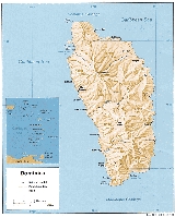
Dominica is the largest and most northerly of the Windward Islands
. The island faces the Atlantic Ocean to the east and the Caribbean Sea to the west. Its nearest neighbors are the French islands of Guadeloupe, some 48 kilometres (30 mi) north, and Martinique, about 40 kilometres (25 mi) south. Oblong-shaped and slightly smaller than New York City, Dominica is 750 square kilometres (290 sq mi) in area, 47 kilometres (29 mi) in length, and 29 kilometres (18 mi) in width. Roseau, the nation's capital and major port, is favorably situated on the sheltered, southwestern coast.
is tropical, moderated by northeast trade wind
s and heavy rain
fall.
Dominica has a tropical wet climate with characteristically warm temperatures and heavy rainfall. Excessive heat and humidity are tempered somewhat by a steady flow of the northeast trade winds, which periodically develop into hurricanes. The steep interior slopes also alter temperatures and winds. Temperature ranges are slight. Average daytime temperatures generally vary from 26 °C (78.8 °F) in January to 32 °C (89.6 °F) in June. Diurnal ranges are usually no greater than 3 C-change in most places, but temperatures dipping to 13 °C (55.4 °F) on the highest peaks are not uncommon.
Most of the island's ample supply of water is brought by the trade winds. Although amounts vary with the location, rain is possible throughout the year, with the greatest monthly totals recorded from June through October. Average yearly rainfall along the windward east coast frequently exceeds 5000 mm (196.9 in), and exposed mountainsides receive up to 9000 mm (354.3 in), among the highest accumulations in the world. Totals on the leeward west coast, however, are only about 1800 mm (70.9 in) per year. Humidities are closely tied to rainfall patterns, with the highest values occurring on windward slopes and the lowest in sheltered areas. Relative humidity readings between 70 percent and 90 percent have been recorded in Roseau.
Hurricanes and severe winds, most likely to occur during the wettest months, occasionally are devastating. The most recent hurricanes of note were David
and Frederic
in August 1979 and Allen
in August 1980. The 1979 hurricanes caused over 40 deaths, 2,500 injuries, and extensive destruction of housing and crops. Many agricultural commodities were destroyed during the 1980 storm, and about 25 percent of the banana crop was destroyed by strong winds in 1984.
Dominica is especially vulnerable to hurricanes as the island is located in what is referred to as the hurricane region. In 1979, Dominica was hit directly by Category 5 Hurricane David
, causing widespread and extreme damage. On August 17, 2007, Hurricane Dean
, a Category 1 at the time, hit the island. A mother and her seven-year-old son died when a landslide
caused by the heavy rains fell onto their house. In another incident two people were injured when a tree fell on their house. Prime Minister
Roosevelt Skerrit
estimated that 100 to 125 homes were damaged, and that the agriculture sector was extensively damaged, in particular the banana crop.
, Pringles Bay, Prince Rupert Bay, Douglas Bay, Toucari Bay, Marceau Bay.
has mountains approaching 5000 feet (1,524 m).
Geologically, Dominica is part of the rugged Lesser Antilles volcanic arc. The country's central spine, a northwest-southeast axis of steep volcanic slopes and deep gorges, generally varies in elevation from 300 to 1400 m (984.3 to 4,593.2 ) above sea level. Several east-west trending mountain spurs extend to the narrow coastal plain, which is studded with sea cliffs and has level stretches no wider than 2000 metres (6,562 ft). The highest peak is Morne Diablotins, at 1447 metres (4,747 ft); Morne Trois Pitons, with an elevation of 1423 metres (4,669 ft), lies farther south and is the site of the national park.
The interior features rugged mountain
s of volcanic
origin. Volcanism is still quite evident on the island, the most popular examples being Dominica's Boiling Lake
and "valley of desolation." The boiling lake (the world's second largest) is within a crater and is fed by a waterfall - the boiling is believed to be caused by the heat of a magma chamber beneath the lake. The valley of desolation is a sulfurous valley of volcanic vents and hot springs that inhibits significant plant growth - in stark contrast to the surrounding rain forest. Technically dormant today, this caldera last erupted in 1880. The area that exploded on 4th January, 1880 was reported to be "fully nine square miles".
.jpg) Dominica's rugged surface is marked by its volcanic past. Rock formations are mainly volcanic andesite and rhyolite, with fallen boulders and sharp-edged protrusions peppering slope bases. The light- to dark-hued clayey and sandy soils, derived from the rocks and decomposed vegetation, are generally fertile and porous. Only a few interior valleys and coastal strips are flat enough for soil accumulations of consequence, however. Although scores of mostly mild seismic shocks were recorded in 1986, volcanic eruptions ceased thousands of years ago. Sulfuric springs and steam vents, largely concentrated in the central and southern parts of the island, remain active, however. One of the largest springs, Boiling Lake, is located in the national park.
Dominica's rugged surface is marked by its volcanic past. Rock formations are mainly volcanic andesite and rhyolite, with fallen boulders and sharp-edged protrusions peppering slope bases. The light- to dark-hued clayey and sandy soils, derived from the rocks and decomposed vegetation, are generally fertile and porous. Only a few interior valleys and coastal strips are flat enough for soil accumulations of consequence, however. Although scores of mostly mild seismic shocks were recorded in 1986, volcanic eruptions ceased thousands of years ago. Sulfuric springs and steam vents, largely concentrated in the central and southern parts of the island, remain active, however. One of the largest springs, Boiling Lake, is located in the national park.
Dominica is water-rich with swift-flowing highland streams, which cascade into deep gorges and form natural pools and crater lakes. The streams are not navigable, but many are sources of hydroelectric power. Trafalgar Falls, located near the national park, is one of the most spectacular sites on the island. The falls has two twin waterfalls known as the mother and father. The falls form a natural pool where the natives and tourist come to enjoy a nice cool bath. The principal rivers flowing westward into the Caribbean are the Layou and the Roseau, and the major one emptying eastward into the Atlantic is the Toulaman. The largest crater lake, called Boeri, is located in the national park. There are 83 "significant" waterways on the island out of a total of 365 rills and brooks.
, broad-winged hawk
s, yellow-crowned night heron
s, and the brown trembler
. Some plants and animals thought to be extinct on surrounding islands can still be found in Dominica's forests.
The Sisserou parrot
is Dominica's national bird and is indigenous to its mountain forests.
The Caribbean Sea
offshore of the island of Dominica is home to many cetaceans. Most notably a small group of sperm whale
s live in this area year round. These are shy animals, but there is a good chance of seeing them if you go out on a calm day. Other cetaceans commonly seen in the area include pilot whale
, fraser's dolphin
, pantropical spotted dolphin
and bottlenose dolphin
. Less commonly seen animals include cuvier's beaked whale
, false killer whale
, pygmy sperm whale
, dwarf sperm whale
, risso's dolphin
, common dolphin
, humpback whale
and Bryde's whale
. This makes Dominica a destination for tourists interested in whale-watching.
Central America and the Caribbean
Area:
total:
754 km²
land:
754 km²
Coastline:
148 km
Maritime claims:
contiguous zone:
24 nmi (44.4 km; 27.6 mi)
exclusive economic zone:
200 nmi (370.4 km; 230.2 mi)
territorial sea:
12 nmi (22.2 km; 13.8 mi)
Land use:
arable land:
9%
permanent crops:
13%
permanent pastures:
3%
forests and woodland:
67%
other:
8% (1993 est.)
Irrigated land:
NA km²
Natural hazards:
Flash floods are a constant threat; destructive hurricanes can be expected during the late summer months
Environment - current issues:
NA
Environment - international agreements:
Party to:
Biodiversity, Climate Change, Desertification, Endangered Species, Environmental Modification, Hazardous Wastes, Law of the Sea
, Ozone Layer Protection, Whaling
Dominica
Dominica , officially the Commonwealth of Dominica, is an island nation in the Lesser Antilles region of the Caribbean Sea, south-southeast of Guadeloupe and northwest of Martinique. Its size is and the highest point in the country is Morne Diablotins, which has an elevation of . The Commonwealth...
is an island
Island
An island or isle is any piece of sub-continental land that is surrounded by water. Very small islands such as emergent land features on atolls can be called islets, cays or keys. An island in a river or lake may be called an eyot , or holm...
in the Caribbean Sea
Caribbean Sea
The Caribbean Sea is a sea of the Atlantic Ocean located in the tropics of the Western hemisphere. It is bounded by Mexico and Central America to the west and southwest, to the north by the Greater Antilles, and to the east by the Lesser Antilles....
, located about halfway between the French islands of Guadeloupe
Guadeloupe
Guadeloupe is an archipelago located in the Leeward Islands, in the Lesser Antilles, with a land area of 1,628 square kilometres and a population of 400,000. It is the first overseas region of France, consisting of a single overseas department. As with the other overseas departments, Guadeloupe...
(to the north) and Martinique
Martinique
Martinique is an island in the eastern Caribbean Sea, with a land area of . Like Guadeloupe, it is an overseas region of France, consisting of a single overseas department. To the northwest lies Dominica, to the south St Lucia, and to the southeast Barbados...
(to the south). Its coordinates are 15 25 N, 61 20 W. It is known as "The Nature Island of the Caribbean" due to its spectacular, lush, and varied flora and fauna, which is protected by an extensive natural park system. It is the fourth largest island in the Caribbean with a population of people mainly from African descent.
The lowest point in the country is at sea level
Sea level
Mean sea level is a measure of the average height of the ocean's surface ; used as a standard in reckoning land elevation...
along the coast, and the highest is Morne Diablotins
Morne Diablotins
Morne Diablotins is the highest mountain in Dominica, an island-nation in the Caribbean Lesser Antilles. It is the second highest mountain in the Lesser Antilles, after La Grande Soufrière in Guadeloupe...
(1447 m (4,747 ft)). The extreme southwestern coast of the island includes a large collapsed submarine caldera. Portions of the exposed rim of this caldera form the southwestern tip of the island at Scott's Head. Natural resources include farming, hydropower
Hydropower
Hydropower, hydraulic power, hydrokinetic power or water power is power that is derived from the force or energy of falling water, which may be harnessed for useful purposes. Since ancient times, hydropower has been used for irrigation and the operation of various mechanical devices, such as...
and timber
Timber
Timber may refer to:* Timber, a term common in the United Kingdom and Australia for wood materials * Timber, Oregon, an unincorporated community in the U.S...
.
Geographically, Dominica is distinctive in many ways. The country has one of the most rugged landscapes in the Caribbean, covered by a largely unexploited, multi-layered rain forest. It is also among the Earth's most rain-drenched lands, and the water runoff forms cascading rivers and natural pools. The island, home to rare species of wildlife, is considered by many as a beautiful, unspoiled tropical preserve. According to a popular West Indian belief, Dominica is the only New World territory that Columbus would still recognize.
Dominica is the largest and most northerly of the Windward Islands
Windward Islands
The Windward Islands are the southern islands of the Lesser Antilles, within the West Indies.-Name and geography:The Windward Islands are called such because they were more windward to sailing ships arriving in the New World than the Leeward Islands, given that the prevailing trade winds in the...
. The island faces the Atlantic Ocean to the east and the Caribbean Sea to the west. Its nearest neighbors are the French islands of Guadeloupe, some 48 kilometres (30 mi) north, and Martinique, about 40 kilometres (25 mi) south. Oblong-shaped and slightly smaller than New York City, Dominica is 750 square kilometres (290 sq mi) in area, 47 kilometres (29 mi) in length, and 29 kilometres (18 mi) in width. Roseau, the nation's capital and major port, is favorably situated on the sheltered, southwestern coast.
Climate
The island's climateClimate
Climate encompasses the statistics of temperature, humidity, atmospheric pressure, wind, rainfall, atmospheric particle count and other meteorological elemental measurements in a given region over long periods...
is tropical, moderated by northeast trade wind
Trade wind
The trade winds are the prevailing pattern of easterly surface winds found in the tropics, within the lower portion of the Earth's atmosphere, in the lower section of the troposphere near the Earth's equator...
s and heavy rain
Rain
Rain is liquid precipitation, as opposed to non-liquid kinds of precipitation such as snow, hail and sleet. Rain requires the presence of a thick layer of the atmosphere to have temperatures above the melting point of water near and above the Earth's surface...
fall.
Dominica has a tropical wet climate with characteristically warm temperatures and heavy rainfall. Excessive heat and humidity are tempered somewhat by a steady flow of the northeast trade winds, which periodically develop into hurricanes. The steep interior slopes also alter temperatures and winds. Temperature ranges are slight. Average daytime temperatures generally vary from 26 °C (78.8 °F) in January to 32 °C (89.6 °F) in June. Diurnal ranges are usually no greater than 3 C-change in most places, but temperatures dipping to 13 °C (55.4 °F) on the highest peaks are not uncommon.
Most of the island's ample supply of water is brought by the trade winds. Although amounts vary with the location, rain is possible throughout the year, with the greatest monthly totals recorded from June through October. Average yearly rainfall along the windward east coast frequently exceeds 5000 mm (196.9 in), and exposed mountainsides receive up to 9000 mm (354.3 in), among the highest accumulations in the world. Totals on the leeward west coast, however, are only about 1800 mm (70.9 in) per year. Humidities are closely tied to rainfall patterns, with the highest values occurring on windward slopes and the lowest in sheltered areas. Relative humidity readings between 70 percent and 90 percent have been recorded in Roseau.
Hurricanes and severe winds, most likely to occur during the wettest months, occasionally are devastating. The most recent hurricanes of note were David
Hurricane David
Hurricane David was the fourth named tropical cyclone, second hurricane, and first major hurricane of the 1979 Atlantic hurricane season. A Category 5 hurricane on the Saffir-Simpson Hurricane Scale, David was among the deadliest hurricanes in the latter half of the 20th century, killing...
and Frederic
Hurricane Frederic
Hurricane Frederic was the sixth tropical cyclone, third hurricane and second major hurricane of the 1979 Atlantic hurricane season. Frederic was the costliest hurricane to ever hit the U.S. Gulf Coast at that particular time...
in August 1979 and Allen
Hurricane Allen
Hurricane Allen was the first and strongest hurricane of the 1980 Atlantic hurricane season. It was one of the strongest hurricanes in recorded history, one of the few hurricanes to reach Category 5 status on the Saffir-Simpson Hurricane Scale on three separate occasions, and spent more time...
in August 1980. The 1979 hurricanes caused over 40 deaths, 2,500 injuries, and extensive destruction of housing and crops. Many agricultural commodities were destroyed during the 1980 storm, and about 25 percent of the banana crop was destroyed by strong winds in 1984.
Dominica is especially vulnerable to hurricanes as the island is located in what is referred to as the hurricane region. In 1979, Dominica was hit directly by Category 5 Hurricane David
Hurricane David
Hurricane David was the fourth named tropical cyclone, second hurricane, and first major hurricane of the 1979 Atlantic hurricane season. A Category 5 hurricane on the Saffir-Simpson Hurricane Scale, David was among the deadliest hurricanes in the latter half of the 20th century, killing...
, causing widespread and extreme damage. On August 17, 2007, Hurricane Dean
Hurricane Dean
The name Dean was used for five tropical cyclones in the Northern Atlantic Ocean:*1983's Tropical Storm Dean, which struck the coast of Virginia, causing minor erosion and flooding...
, a Category 1 at the time, hit the island. A mother and her seven-year-old son died when a landslide
Landslide
A landslide or landslip is a geological phenomenon which includes a wide range of ground movement, such as rockfalls, deep failure of slopes and shallow debris flows, which can occur in offshore, coastal and onshore environments...
caused by the heavy rains fell onto their house. In another incident two people were injured when a tree fell on their house. Prime Minister
Prime Minister of Dominica
The Prime Minister of Dominica is the head of government in the Commonwealth of Dominica. Nominally, the position was created on November 3, 1978 when Dominica gained independence from the United Kingdom...
Roosevelt Skerrit
Roosevelt Skerrit
Roosevelt Skerrit is a Dominican politician who has been Prime Minister of Dominica since 2004; he has also been the Member of Parliament for the Vieille Case constituency since 2000...
estimated that 100 to 125 homes were damaged, and that the agriculture sector was extensively damaged, in particular the banana crop.
Bays
Bays are as follows from the northern tip of the island in a clockwise direction: Agoucha Bay, Autrou Bay, Sandwich Bay, Grand Baptiste Bay, Petit Bapitiste Bay, La Taille Bay, Rough Bay, Marigot Bay, Walker's Rest Bay, Sophia Bay, Londonderry Bay, Mango Hole Bay, Middle Bay, Panto Hole Bay, Petite Soufriere Bay, Soufriere Bay, Woodbridge BayWoodbridge Bay
Woodbridge Bay is a bay on the southwestern coast of Dominica off Stock Farm, north of the main centre of Roseau and south of the village of Canefield. It contains the main port of entry into Dominica....
, Pringles Bay, Prince Rupert Bay, Douglas Bay, Toucari Bay, Marceau Bay.
Geology
Dominica was the last island to be formed in the Caribbean. The island was created by volcanic action about 26 mya. It lies upon two opposing tectonic plates. This explains why an island a bit bigger than Martha's VineyardMartha's Vineyard
Martha's Vineyard is an island located south of Cape Cod in Massachusetts, known for being an affluent summer colony....
has mountains approaching 5000 feet (1,524 m).
Geologically, Dominica is part of the rugged Lesser Antilles volcanic arc. The country's central spine, a northwest-southeast axis of steep volcanic slopes and deep gorges, generally varies in elevation from 300 to 1400 m (984.3 to 4,593.2 ) above sea level. Several east-west trending mountain spurs extend to the narrow coastal plain, which is studded with sea cliffs and has level stretches no wider than 2000 metres (6,562 ft). The highest peak is Morne Diablotins, at 1447 metres (4,747 ft); Morne Trois Pitons, with an elevation of 1423 metres (4,669 ft), lies farther south and is the site of the national park.
The interior features rugged mountain
Mountain
Image:Himalaya_annotated.jpg|thumb|right|The Himalayan mountain range with Mount Everestrect 58 14 160 49 Chomo Lonzorect 200 28 335 52 Makalurect 378 24 566 45 Mount Everestrect 188 581 920 656 Tibetan Plateaurect 250 406 340 427 Rong River...
s of volcanic
Volcano
2. Bedrock3. Conduit 4. Base5. Sill6. Dike7. Layers of ash emitted by the volcano8. Flank| 9. Layers of lava emitted by the volcano10. Throat11. Parasitic cone12. Lava flow13. Vent14. Crater15...
origin. Volcanism is still quite evident on the island, the most popular examples being Dominica's Boiling Lake
Boiling Lake
Dominica's Boiling Lake is situated in the Morne Trois Pitons National Park - Dominica's World Heritage site. It is a flooded fumarole 6.5 miles east of Roseau, Dominica. It is filled with bubbling greyish-blue water that is usually enveloped in a cloud of vapour. The lake is approximately 200 ft ...
and "valley of desolation." The boiling lake (the world's second largest) is within a crater and is fed by a waterfall - the boiling is believed to be caused by the heat of a magma chamber beneath the lake. The valley of desolation is a sulfurous valley of volcanic vents and hot springs that inhibits significant plant growth - in stark contrast to the surrounding rain forest. Technically dormant today, this caldera last erupted in 1880. The area that exploded on 4th January, 1880 was reported to be "fully nine square miles".
Dominica is water-rich with swift-flowing highland streams, which cascade into deep gorges and form natural pools and crater lakes. The streams are not navigable, but many are sources of hydroelectric power. Trafalgar Falls, located near the national park, is one of the most spectacular sites on the island. The falls has two twin waterfalls known as the mother and father. The falls form a natural pool where the natives and tourist come to enjoy a nice cool bath. The principal rivers flowing westward into the Caribbean are the Layou and the Roseau, and the major one emptying eastward into the Atlantic is the Toulaman. The largest crater lake, called Boeri, is located in the national park. There are 83 "significant" waterways on the island out of a total of 365 rills and brooks.
Natural history
There are 172 species of birds, including four species of hummingbirdHummingbird
Hummingbirds are birds that comprise the family Trochilidae. They are among the smallest of birds, most species measuring in the 7.5–13 cm range. Indeed, the smallest extant bird species is a hummingbird, the 5-cm Bee Hummingbird. They can hover in mid-air by rapidly flapping their wings...
, broad-winged hawk
Broad-winged Hawk
The Broad-winged Hawk is a small hawk of the genus Buteo. During the summer some subspecies are distributed over eastern North America, as far west as British Columbia and Texas; they then migrate south to winter in the neotropics from Mexico down to southern Brazil. Other subspecies are all-year...
s, yellow-crowned night heron
Yellow-crowned Night Heron
The Yellow-crowned Night Heron , also called the American Night Heron or squawk, is a fairly small heron, similar in appearance to the Black-crowned Night Heron...
s, and the brown trembler
Brown Trembler
The Brown Trembler is a species of bird in the Mimidae family. Northern birds from Guadeloupe northwards may represent a separate species from those on Dominica and St. Vincent....
. Some plants and animals thought to be extinct on surrounding islands can still be found in Dominica's forests.
The Sisserou parrot
Imperial Parrot
The Imperial Amazon, Amazona imperialis, also known as the Imperial Parrot, Dominican Amazon, August Amazon, or Sisserou, is a green-and-purple-plumaged amazon parrot. It is the largest member in the diverse genus Amazona measuring 48 cm in length and weighing up to 900 g when fully grown...
is Dominica's national bird and is indigenous to its mountain forests.
The Caribbean Sea
Caribbean Sea
The Caribbean Sea is a sea of the Atlantic Ocean located in the tropics of the Western hemisphere. It is bounded by Mexico and Central America to the west and southwest, to the north by the Greater Antilles, and to the east by the Lesser Antilles....
offshore of the island of Dominica is home to many cetaceans. Most notably a small group of sperm whale
Sperm Whale
The sperm whale, Physeter macrocephalus, is a marine mammal species, order Cetacea, a toothed whale having the largest brain of any animal. The name comes from the milky-white waxy substance, spermaceti, found in the animal's head. The sperm whale is the only living member of genus Physeter...
s live in this area year round. These are shy animals, but there is a good chance of seeing them if you go out on a calm day. Other cetaceans commonly seen in the area include pilot whale
Pilot whale
Pilot whales are cetaceans belonging to the genus Globicephala. There are two extant species, the long-finned pilot whale and the short-finned pilot whale . The two are not readily distinguished at sea and analysis of the skulls is the best way to tell the difference between them...
, fraser's dolphin
Fraser's Dolphin
Fraser's Dolphin or Sarawak Dolphin is a cetacean in the family Delphinidae found in deep waters in the Pacific Ocean and to a lesser extent in the Indian and Atlantic Oceans.-Taxonomy:...
, pantropical spotted dolphin
Pantropical Spotted Dolphin
The Pantropical Spotted Dolphin is a species of dolphin found in all the world's temperate and tropical oceans. The species was beginning to come under threat due to the killing of millions of individuals in tuna purse seines...
and bottlenose dolphin
Bottlenose Dolphin
Bottlenose dolphins, the genus Tursiops, are the most common and well-known members of the family Delphinidae, the family of oceanic dolphins. Recent molecular studies show the genus contains two species, the common bottlenose dolphin and the Indo-Pacific bottlenose dolphin , instead of one...
. Less commonly seen animals include cuvier's beaked whale
Cuvier's Beaked Whale
Cuvier's beaked whale is the most widely distributed of all the beaked whales. It is the only member of the genus Ziphius. Another common name for the species is goose-beaked whale because its head is said to be shaped like the beak of a goose. Georges Cuvier first described it in 1823 from part...
, false killer whale
False Killer Whale
The False Killer Whale is a cetacean, and the third largest member of the oceanic dolphin family . It lives in temperate and tropical waters throughout the world. As its name implies, the False Killer Whale shares characteristics, such as appearance, with the more widely known Orca...
, pygmy sperm whale
Pygmy Sperm Whale
The Pygmy Sperm Whale is one of three species of toothed whale in the sperm whale family. They are not often sighted at sea, and most of what is known about them comes from the examination of stranded specimens.-Taxonomy:...
, dwarf sperm whale
Dwarf Sperm Whale
The Dwarf Sperm Whale is one of three species in the sperm whale family. They are not often sighted at sea. As such, most information is a result of the study of stranded carcasses.-Taxonomy:...
, risso's dolphin
Risso's Dolphin
Risso's dolphin is the only species of dolphin in the genus Grampus.-Taxonomy:Risso's dolphin is named after Antoine Risso, whose description formed the basis of the first public description of the animal, by Georges Cuvier, in 1812...
, common dolphin
Common dolphin
The common dolphin is the name given to two species of dolphin making up the genus Delphinus.Prior to the mid-1990s, most taxonomists only recognised one species in this genus, the common dolphin Delphinus delphis...
, humpback whale
Humpback Whale
The humpback whale is a species of baleen whale. One of the larger rorqual species, adults range in length from and weigh approximately . The humpback has a distinctive body shape, with unusually long pectoral fins and a knobbly head. It is an acrobatic animal, often breaching and slapping the...
and Bryde's whale
Bryde's Whale
Bryde's whales are baleen whales, one of the "great whales" or rorquals. They prefer tropical and temperate waters over the polar seas that other whales in their family frequent. They are largely coastal rather than pelagic. Bryde's whales are very similar in appearance to sei whales and almost as...
. This makes Dominica a destination for tourists interested in whale-watching.
Statistics
Map references:Central America and the Caribbean
Area:
total:
754 km²
1 E8 m²
To help compare different orders of magnitude and geographical regions, listed below are areas between 100 km2 and 1000 km2. See also areas of other orders of magnitude.* Areas less than 100 km2* 100 km2 is equal to:** 1 E+8 m²...
land:
754 km²
Coastline:
148 km
Maritime claims:
contiguous zone:
24 nmi (44.4 km; 27.6 mi)
exclusive economic zone:
200 nmi (370.4 km; 230.2 mi)
territorial sea:
12 nmi (22.2 km; 13.8 mi)
Land use:
arable land:
9%
permanent crops:
13%
permanent pastures:
3%
forests and woodland:
67%
other:
8% (1993 est.)
Irrigated land:
NA km²
Natural hazards:
Flash floods are a constant threat; destructive hurricanes can be expected during the late summer months
Environment - current issues:
NA
Environment - international agreements:
Party to:
Biodiversity, Climate Change, Desertification, Endangered Species, Environmental Modification, Hazardous Wastes, Law of the Sea
Law of the sea
Law of the sea may refer to:* United Nations Convention on the Law of the Sea* Admiralty law* The Custom of the Sea...
, Ozone Layer Protection, Whaling