
Hurricane Allen
Encyclopedia
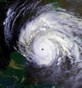
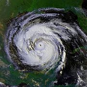
Hurricane Allen was the first and strongest hurricane of the 1980 Atlantic hurricane season
. It was one of the strongest hurricanes in recorded history, one of the few hurricanes to reach Category 5 status on the Saffir-Simpson Hurricane Scale
on three separate occasions, and spent more time as a Category 5 than any other Atlantic hurricane. Allen is the second of only two hurricanes in the recorded history of the Atlantic basin to achieve sustained winds of 190 mph (305.8 km/h), after Hurricane Camille
in 1969.
Throughout its life, Allen moved through the deep tropics on a west-northwesterly course through the tropical Atlantic ocean
, Caribbean Sea
, and Gulf of Mexico
before making landfall near the United States
/Mexico
border. At peak strength, it passed near Haiti
, causing hundreds of deaths and heavy damage. After crossing the Gulf of Mexico, Allen weakened as it struck the lower Texas coast, causing high winds, a significant storm surge, and heavy rainfall which caused damage to southern Texas
. Overall, Allen killed 290 people and left just over $1.5 billion in damage (1980 USD), mostly within the United States and Haiti. Due to its impact, the name Allen was retired from the six-year revolving list of Atlantic tropical cyclone names in 1981 and the name was replaced by Andrew. The name Andrew was subsequently retired after the 1992 season's Hurricane Andrew
. The dissipating storm precipitated the end of the Heat Wave of 1980 in places like Dallas/Fort Worth, Texas
, which had recorded 69 days of 100 °F (37.8 °C) heat.
which originated from a tropical wave that previously moved off the African coastline on July 30. The system developed as it moved westward, becoming a tropical depression on August 1. However, the National Hurricane Center
did not initiate advisories on Allen until almost 24 hours later, while centered 1300 mi (2,092.1 km) east of the Windward Islands
. Early on August 2, as the depression moved towards the Caribbean, it had intensified, and became the first named storm of the season. The National Hurricane Center noted that conditions appeared favorable for further intensification. However, it was also noted that a large cold-low north of Puerto Rico
was producing strong westerly wind shear, which would cause Allen to possibly encounter unfavorable conditions within 72 hours. Although slower forward movement was anticipated, Allen kept at generally the same westward pace between 17 and 23 mph (27.4 and 37 km/h). By August 3, the National Hurricane Center retracted predictions of less favorable conditions from the cold-low north of Puerto Rico, since that weather system was weakening and moving westward.
At 1600 UTC on August 3, the National Hurricane Center upgraded Allen to hurricane status, as an Air Force Plane recorded winds of 100 mph (155 km/h). However, in post-analysis, it was discovered that Allen had been a hurricane since 0000 UTC on August 3. Shortly after the upgrade, Allen began a period of rapid deepening, and intensified into a major hurricane at 0000 UTC August 4, while roughly 38 mi (61.2 km) northwest of Bridgetown
, Barbados
. Six hours later, Allen passed only 8 mi (12.9 km) south of St. Lucia at 0600 UTC. Although the National Hurricane Center noted that conditions favored slow strengthening, Allen continued to rapidly intensify, and became a Category 4 hurricane only two hours after that advisory. Later on August 4, the National Hurricane Center noted a barometric pressure of 946 mbar (27.9 inHg), and that the it would not drop significantly within 24 hours. Shortly before 0000 UTC on August 5, the minimum pressure decreased to 924 mbar (27.3 inHg), which was noted as equivalent to Hurricane David
in the previous season
.
By August 5, Allen intensified into a Category 5 hurricane during while south of Puerto Rico
. This made Allen the earliest Category 5 hurricane in the Atlantic on record, but was later surpassed by Hurricane Emily
which reached that intensity on July 16, 2005. During this time, Allen attained a central pressure of 911 mbar (26.9 inHg), the lowest pressure on record in the eastern Caribbean sea. Hence, the barometric pressure dropped by 35 mbar (1 inHg) less than 10 hours after the National Hurricane Center stated that the pressure would not decrease significantly within 24 hours.
The eye passed between Hispaniola
and Jamaica
as a Category 4 hurricane. After weakening due to friction with the mountains of Haiti and Jamaica, Allen intensified back to a Category 5 hurricane, retaining this intensity for over a day. The storm moved between Cuba
and the Yucatán Peninsula
, reaching its minimum pressure of 899 mbar (26.5 inHg) while crossing the Yucatán Channel
. During Allen's trek through the Caribbean Sea
and the Gulf of Mexico
, its center of circulation never crossed over land despite its close passage to various islands in and around the Caribbean sea.
Allen again weakened to a Category 4 storm due to friction with Mexico, but restrengthened into a Category 5 hurricane for a third time as it moved over the open waters of the Gulf of Mexico, keeping this intensity for nearly a full day and with a pressure drop to 909 mbar (26.8 inHg), the lowest pressure ever recorded in the western Gulf of Mexico. Shortly before landfall, a dry air mass in the western Gulf of Mexico caused the storm to weaken substantially. Allen made landfall north of Brownsville, Texas
as a Category 3 storm with maximum sustained wind
s of 115 mph (185 km/h).
warnings and a hurricane watch were issued for the islands of Barbados
, St. Lucia, St. Vincent
, Dominica
, Grenada
, Martinique
, and Guadeloupe
during the daylight hours of August 3. Gale warnings were in effect for Antigua
from 11 am on August 3 until 11 am on August 4. Hurricane warnings were raised for Barbados, St. Vincent, St. Lucia, Martinique, and Dominica from the early afternoon of August 3 until the late morning of August 4. As Allen moved into the Caribbean sea, hurricane watches were issued for southeastern sections of the Dominican Republic
and the southwestern peninsula of Haiti from 11 am on August 4 until the morning of August 5. Gale warnings were then in effect for the southern Dominican Republic from the night of August 4 into the night of August 5, while southern Haiti maintained the warnings from the night of August 4 into the morning of August 5. The hurricane watch was issued for Jamaica during the morning hours of August 5, while hurricane warnings were raised for the southwest peninsula of Haiti from the late morning of August 5 into the morning of August 6. Hurricane warnings went into effect for Jamaica from around noon on August 5 until late in the afternoon of August 6. The Cayman Islands
saw hurricane watches issued from the afternoon of August 5 into the morning of August 6 before the watches were upgraded to hurricane warnings from the morning until late afternoon of August 6.
 As Allen approached the Gulf of Mexico, hurricane warnings were raised for the northeast Yucatán peninsula of Mexico from the afternoon of August 6 into the morning of August 8. Gale warnings were in effect for the Florida Keys
from the evening of August 6 into the early morning of August 8. As Allen approached its final landfall, the northeast Mexican coast and Texas coast were placed under a hurricane watch from the morning of August 8 until the morning of August 9 for Mexico and the afternoon of August 9 for Texas. Hurricane warnings were posted for the Texas coast during the afternoon of August 8, and were lowered north of Freeport, Texas
during the afternoon of August 9 and south of Freeport during the afternoon of August 10. Gale warnings and a hurricane watch were issued for the Louisiana
coast from Vermilion Bay
westward from the afternoon of August 8 into the afternoon of August 9. Hurricane warnings were in effect for northeast Mexico from the early afternoon of August 9 into the late afternoon of August 10. Hurricane warnings were downgraded to gale warnings between High Island, Texas
and Freeport, Texas between the late afternoon of August 9 and the late afternoon of August 10. Hurricane watches were dropped for the Louisiana coast during the late afternoon of August 9. Hurricane warnings were downgraded to gale warnings for the lower Texas coast south of Freeport from the late afternoon of August 10 into the early morning of August 11.
) in damages and killed at least 271 people throughout its course (including indirect deaths).
In Barbados, preliminary damages were estimated to be $1.5 million (1980 USD
). About 500 houses were either damaged or destroyed. No deaths were reported. St. Lucia sustained catastrophic damage from the strong category 3 hurricane. Sustained winds of 90 knots (176.4 km/h) and a sea level pressure as low as 967 millibars (28.6 inHg) were reported at Hewanorra. Eighteen people lost their lives as a result of the storm's passage. One death in Guadeloupe was attributed to Allen. In Martinique, damage was extensive as the storm passed 50 miles (80.5 km) south of the island. Waves 6 metres (19.7 ft) high battered the coast of the island during the storm.
In the central Caribbean, Cayman Brac
was hit by winds in excess of 115 mi/h which caused considerable property damage. A coral reef
at Discover Bay, Jamaica was devastated by the wave action from the storm. Offshore Jamaica, greater numbers of smaller-sized Damselfish
es was witnessed in the wake of Allen. Eight deaths in Jamaica were attributed to Allen. Damage was very significant along the northeast coast, where the hurricane made its closest approach to the island and created a 12 metres (39.4 ft) storm surge. Three deaths were attributed to Allen in Cuba
.
Extensive damage occurred in Haiti
due to high winds and flash flood
ing. Total costs for that country were estimated to be at more than $400 million (1980 USD
). Roughly 60% of the nation's coffee crop was destroyed. In all, 220 people were killed and 835,000 were left homeless. In Port-au-Prince
, 41 deaths were caused by tin roofs flying off and around 1200 were made homeless by flooding.
s with the passage of Allen, with the highest totals exceeding 7 inches (177.8 mm). The hurricane earlier brushed the Yucatán Peninsula. As Allen only affected sparsely populated regions of Mexico, there were no reports of significant damage.
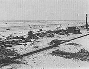
 In Texas
, the storm surge
was reported as high as 12 feet (3.7 m) at Port Mansfield
, though it may have been higher elsewhere along the Texas coast. A peak wind gust of 129 mi/h was also measured at Port Mansfield. Tropical storm-force winds in Corpus Christi, Texas
blew roof gravel through the city, which led to substantial glass breakage to the 18-story Guarantee Bank Building and a 12-story wing of Spohn hospital. The storm caused seven deaths in Texas and 17 in Louisiana
(most resulting from the crash of a helicopter evacuating workers from an offshore platform). Allen spawned several tornadoes in Texas. One tornado caused $100 million in damage when it hit Austin, Texas
, making it the costliest tropical cyclone
-spawned tornado in recorded history. Overall, however, the storm caused limited damage in the United States due to its suddenly diminished power and because its highest tides and winds hit a sparsely-populated portion of the Texas coast.
Allen dumped 10 inches (254 mm) to 20 inches (508 mm) of rain in south Texas, ending a summer-long drought
during the Heat Wave of 1980. Its storm total rainfall map is shown to the right.
.
 When Allen reached Category 5 intensity on August 5, it became the earliest Category 5 storm ever recorded. This record stood until Hurricane Emily
shattered it on July 16, 2005. Allen is one of three Atlantic hurricanes to reach Category 5 on the Saffir-Simpson hurricane scale
on three separate occasions, the others being Hurricane Ivan
and Hurricane Isabel
. Allen also produced the fifth-lowest minimum pressure ever recorded in the Atlantic basin at 899 mbar
(hPa
) and was the strongest known hurricane in the basin, in terms of pressure, since 1935. Until then, it was the second strongest hurricane by pressure in the Atlantic Basin, but was since pushed down to fifth, and no hurricane has achieved 190 miles per hour (305.8 km/h) winds in this basin since then. It remains the most intense storm ever in August. Allen spent nearly 3 days as a Category 5 storm, by far the highest of any Atlantic hurricane. Five typhoons have spent longer as Category 5 storms, including most recently Karen and Nancy
in the early 1960s.
1980 Atlantic hurricane season
The 1980 Atlantic hurricane season officially began on June 1, 1980, and lasted until November 30, 1980. These dates conventionally delimit the period of each year when most tropical cyclones form in the Atlantic basin. The season was fairly active, with eleven storms forming, of which nine reached...
. It was one of the strongest hurricanes in recorded history, one of the few hurricanes to reach Category 5 status on the Saffir-Simpson Hurricane Scale
Saffir-Simpson Hurricane Scale
The Saffir–Simpson Hurricane Scale , or the Saffir–Simpson Hurricane Wind Scale , classifies hurricanes — Western Hemisphere tropical cyclones that exceed the intensities of tropical depressions and tropical storms — into five categories distinguished by the intensities of their sustained winds...
on three separate occasions, and spent more time as a Category 5 than any other Atlantic hurricane. Allen is the second of only two hurricanes in the recorded history of the Atlantic basin to achieve sustained winds of 190 mph (305.8 km/h), after Hurricane Camille
Hurricane Camille
Hurricane Camille was the third and strongest tropical cyclone and second hurricane during the 1969 Atlantic hurricane season. The second of three catastrophic Category 5 hurricanes to make landfall in the United States during the 20th century , which it did near the mouth of the Mississippi River...
in 1969.
Throughout its life, Allen moved through the deep tropics on a west-northwesterly course through the tropical Atlantic ocean
Atlantic Ocean
The Atlantic Ocean is the second-largest of the world's oceanic divisions. With a total area of about , it covers approximately 20% of the Earth's surface and about 26% of its water surface area...
, Caribbean Sea
Caribbean Sea
The Caribbean Sea is a sea of the Atlantic Ocean located in the tropics of the Western hemisphere. It is bounded by Mexico and Central America to the west and southwest, to the north by the Greater Antilles, and to the east by the Lesser Antilles....
, and Gulf of Mexico
Gulf of Mexico
The Gulf of Mexico is a partially landlocked ocean basin largely surrounded by the North American continent and the island of Cuba. It is bounded on the northeast, north and northwest by the Gulf Coast of the United States, on the southwest and south by Mexico, and on the southeast by Cuba. In...
before making landfall near the United States
United States
The United States of America is a federal constitutional republic comprising fifty states and a federal district...
/Mexico
Mexico
The United Mexican States , commonly known as Mexico , is a federal constitutional republic in North America. It is bordered on the north by the United States; on the south and west by the Pacific Ocean; on the southeast by Guatemala, Belize, and the Caribbean Sea; and on the east by the Gulf of...
border. At peak strength, it passed near Haiti
Haiti
Haiti , officially the Republic of Haiti , is a Caribbean country. It occupies the western, smaller portion of the island of Hispaniola, in the Greater Antillean archipelago, which it shares with the Dominican Republic. Ayiti was the indigenous Taíno or Amerindian name for the island...
, causing hundreds of deaths and heavy damage. After crossing the Gulf of Mexico, Allen weakened as it struck the lower Texas coast, causing high winds, a significant storm surge, and heavy rainfall which caused damage to southern Texas
Texas
Texas is the second largest U.S. state by both area and population, and the largest state by area in the contiguous United States.The name, based on the Caddo word "Tejas" meaning "friends" or "allies", was applied by the Spanish to the Caddo themselves and to the region of their settlement in...
. Overall, Allen killed 290 people and left just over $1.5 billion in damage (1980 USD), mostly within the United States and Haiti. Due to its impact, the name Allen was retired from the six-year revolving list of Atlantic tropical cyclone names in 1981 and the name was replaced by Andrew. The name Andrew was subsequently retired after the 1992 season's Hurricane Andrew
Hurricane Andrew
Hurricane Andrew was the third Category 5 hurricane to make landfall in the United States, after the Labor Day Hurricane of 1935 and Hurricane Camille in 1969. Andrew was the first named storm and only major hurricane of the otherwise inactive 1992 Atlantic hurricane season...
. The dissipating storm precipitated the end of the Heat Wave of 1980 in places like Dallas/Fort Worth, Texas
Texas
Texas is the second largest U.S. state by both area and population, and the largest state by area in the contiguous United States.The name, based on the Caddo word "Tejas" meaning "friends" or "allies", was applied by the Spanish to the Caddo themselves and to the region of their settlement in...
, which had recorded 69 days of 100 °F (37.8 °C) heat.
Meteorological history
Allen was an early Cape Verde-type hurricaneCape Verde-type hurricane
A Cape Verde-type hurricane is an Atlantic hurricane that develops near the Cape Verde islands, off the west coast of Africa. The average hurricane season has about two Cape Verde-type hurricanes, which are usually the largest and most intense storms of the season because they often have plenty of...
which originated from a tropical wave that previously moved off the African coastline on July 30. The system developed as it moved westward, becoming a tropical depression on August 1. However, the National Hurricane Center
National Hurricane Center
The National Hurricane Center , located at Florida International University in Miami, Florida, is the division of the National Weather Service responsible for tracking and predicting weather systems within the tropics between the Prime Meridian and the 140th meridian west poleward to the 30th...
did not initiate advisories on Allen until almost 24 hours later, while centered 1300 mi (2,092.1 km) east of the Windward Islands
Windward Islands
The Windward Islands are the southern islands of the Lesser Antilles, within the West Indies.-Name and geography:The Windward Islands are called such because they were more windward to sailing ships arriving in the New World than the Leeward Islands, given that the prevailing trade winds in the...
. Early on August 2, as the depression moved towards the Caribbean, it had intensified, and became the first named storm of the season. The National Hurricane Center noted that conditions appeared favorable for further intensification. However, it was also noted that a large cold-low north of Puerto Rico
Puerto Rico
Puerto Rico , officially the Commonwealth of Puerto Rico , is an unincorporated territory of the United States, located in the northeastern Caribbean, east of the Dominican Republic and west of both the United States Virgin Islands and the British Virgin Islands.Puerto Rico comprises an...
was producing strong westerly wind shear, which would cause Allen to possibly encounter unfavorable conditions within 72 hours. Although slower forward movement was anticipated, Allen kept at generally the same westward pace between 17 and 23 mph (27.4 and 37 km/h). By August 3, the National Hurricane Center retracted predictions of less favorable conditions from the cold-low north of Puerto Rico, since that weather system was weakening and moving westward.
At 1600 UTC on August 3, the National Hurricane Center upgraded Allen to hurricane status, as an Air Force Plane recorded winds of 100 mph (155 km/h). However, in post-analysis, it was discovered that Allen had been a hurricane since 0000 UTC on August 3. Shortly after the upgrade, Allen began a period of rapid deepening, and intensified into a major hurricane at 0000 UTC August 4, while roughly 38 mi (61.2 km) northwest of Bridgetown
Bridgetown
The city of Bridgetown , metropolitan pop 96,578 , is the capital and largest city of the nation of Barbados. Formerly, the Town of Saint Michael, the Greater Bridgetown area is located within the parish of Saint Michael...
, Barbados
Barbados
Barbados is an island country in the Lesser Antilles. It is in length and as much as in width, amounting to . It is situated in the western area of the North Atlantic and 100 kilometres east of the Windward Islands and the Caribbean Sea; therein, it is about east of the islands of Saint...
. Six hours later, Allen passed only 8 mi (12.9 km) south of St. Lucia at 0600 UTC. Although the National Hurricane Center noted that conditions favored slow strengthening, Allen continued to rapidly intensify, and became a Category 4 hurricane only two hours after that advisory. Later on August 4, the National Hurricane Center noted a barometric pressure of 946 mbar (27.9 inHg), and that the it would not drop significantly within 24 hours. Shortly before 0000 UTC on August 5, the minimum pressure decreased to 924 mbar (27.3 inHg), which was noted as equivalent to Hurricane David
Hurricane David
Hurricane David was the fourth named tropical cyclone, second hurricane, and first major hurricane of the 1979 Atlantic hurricane season. A Category 5 hurricane on the Saffir-Simpson Hurricane Scale, David was among the deadliest hurricanes in the latter half of the 20th century, killing...
in the previous season
1979 Atlantic hurricane season
The 1979 Atlantic hurricane season was the first in which the Atlantic hurricane naming list included both male and female names. It officially began on June 1 and lasted until November 30, and there was tropical cyclone activity in every month. The dates conventionally delimit the period of each...
.
By August 5, Allen intensified into a Category 5 hurricane during while south of Puerto Rico
Puerto Rico
Puerto Rico , officially the Commonwealth of Puerto Rico , is an unincorporated territory of the United States, located in the northeastern Caribbean, east of the Dominican Republic and west of both the United States Virgin Islands and the British Virgin Islands.Puerto Rico comprises an...
. This made Allen the earliest Category 5 hurricane in the Atlantic on record, but was later surpassed by Hurricane Emily
Hurricane Emily (2005)
Hurricane Emily was a powerful, early season tropical cyclone that caused significant damage across the Caribbean Sea to Mexico. A Cape Verde-type hurricane, the storm formed on July 10, 2005, in the central Atlantic Ocean before passing through the Windward Islands on July 14...
which reached that intensity on July 16, 2005. During this time, Allen attained a central pressure of 911 mbar (26.9 inHg), the lowest pressure on record in the eastern Caribbean sea. Hence, the barometric pressure dropped by 35 mbar (1 inHg) less than 10 hours after the National Hurricane Center stated that the pressure would not decrease significantly within 24 hours.
The eye passed between Hispaniola
Hispaniola
Hispaniola is a major island in the Caribbean, containing the two sovereign states of the Dominican Republic and Haiti. The island is located between the islands of Cuba to the west and Puerto Rico to the east, within the hurricane belt...
and Jamaica
Jamaica
Jamaica is an island nation of the Greater Antilles, in length, up to in width and 10,990 square kilometres in area. It is situated in the Caribbean Sea, about south of Cuba, and west of Hispaniola, the island harbouring the nation-states Haiti and the Dominican Republic...
as a Category 4 hurricane. After weakening due to friction with the mountains of Haiti and Jamaica, Allen intensified back to a Category 5 hurricane, retaining this intensity for over a day. The storm moved between Cuba
Cuba
The Republic of Cuba is an island nation in the Caribbean. The nation of Cuba consists of the main island of Cuba, the Isla de la Juventud, and several archipelagos. Havana is the largest city in Cuba and the country's capital. Santiago de Cuba is the second largest city...
and the Yucatán Peninsula
Yucatán Peninsula
The Yucatán Peninsula, in southeastern Mexico, separates the Caribbean Sea from the Gulf of Mexico, with the northern coastline on the Yucatán Channel...
, reaching its minimum pressure of 899 mbar (26.5 inHg) while crossing the Yucatán Channel
Yucatán Channel
The Yucatán Channel is a strait between Mexico and Cuba. It connects the Yucatán Basin of the Caribbean Sea with the Gulf of Mexico. The strait is across between Cape Catoche in Mexico and Cape San Antonio, Cuba and reaches a maximum depth of .-References:...
. During Allen's trek through the Caribbean Sea
Caribbean Sea
The Caribbean Sea is a sea of the Atlantic Ocean located in the tropics of the Western hemisphere. It is bounded by Mexico and Central America to the west and southwest, to the north by the Greater Antilles, and to the east by the Lesser Antilles....
and the Gulf of Mexico
Gulf of Mexico
The Gulf of Mexico is a partially landlocked ocean basin largely surrounded by the North American continent and the island of Cuba. It is bounded on the northeast, north and northwest by the Gulf Coast of the United States, on the southwest and south by Mexico, and on the southeast by Cuba. In...
, its center of circulation never crossed over land despite its close passage to various islands in and around the Caribbean sea.
Allen again weakened to a Category 4 storm due to friction with Mexico, but restrengthened into a Category 5 hurricane for a third time as it moved over the open waters of the Gulf of Mexico, keeping this intensity for nearly a full day and with a pressure drop to 909 mbar (26.8 inHg), the lowest pressure ever recorded in the western Gulf of Mexico. Shortly before landfall, a dry air mass in the western Gulf of Mexico caused the storm to weaken substantially. Allen made landfall north of Brownsville, Texas
Brownsville, Texas
Brownsville is a city in the southernmost tip of the state of Texas, in the United States. It is located on the northern bank of the Rio Grande, directly north and across the border from Matamoros, Tamaulipas, Mexico. Brownsville is the 16th largest city in the state of Texas with a population of...
as a Category 3 storm with maximum sustained wind
Maximum sustained wind
The maximum sustained winds associated with a tropical cyclone are a common indicator of the intensity of the storm. Within a mature tropical cyclone, they are found within the eyewall at a distance defined as the radius of maximum wind, or RMW. Unlike gusts, the value of these winds are...
s of 115 mph (185 km/h).
Preparations
As Allen approached the Caribbean sea, galeGale
A gale is a very strong wind. There are conflicting definitions of how strong a wind must be to be considered a gale. The U.S. government's National Weather Service defines a gale as 34–47 knots of sustained surface winds. Forecasters typically issue gale warnings when winds of this strength are...
warnings and a hurricane watch were issued for the islands of Barbados
Barbados
Barbados is an island country in the Lesser Antilles. It is in length and as much as in width, amounting to . It is situated in the western area of the North Atlantic and 100 kilometres east of the Windward Islands and the Caribbean Sea; therein, it is about east of the islands of Saint...
, St. Lucia, St. Vincent
Saint Vincent (island)
Saint Vincent is a volcanic island in the Caribbean. It is the largest island of the chain called Saint Vincent and the Grenadines. It is located in the Caribbean Sea, between Saint Lucia and Grenada. It is composed of partially submerged volcanic mountains...
, Dominica
Dominica
Dominica , officially the Commonwealth of Dominica, is an island nation in the Lesser Antilles region of the Caribbean Sea, south-southeast of Guadeloupe and northwest of Martinique. Its size is and the highest point in the country is Morne Diablotins, which has an elevation of . The Commonwealth...
, Grenada
Grenada
Grenada is an island country and Commonwealth Realm consisting of the island of Grenada and six smaller islands at the southern end of the Grenadines in the southeastern Caribbean Sea...
, Martinique
Martinique
Martinique is an island in the eastern Caribbean Sea, with a land area of . Like Guadeloupe, it is an overseas region of France, consisting of a single overseas department. To the northwest lies Dominica, to the south St Lucia, and to the southeast Barbados...
, and Guadeloupe
Guadeloupe
Guadeloupe is an archipelago located in the Leeward Islands, in the Lesser Antilles, with a land area of 1,628 square kilometres and a population of 400,000. It is the first overseas region of France, consisting of a single overseas department. As with the other overseas departments, Guadeloupe...
during the daylight hours of August 3. Gale warnings were in effect for Antigua
Antigua
Antigua , also known as Waladli, is an island in the West Indies, in the Leeward Islands in the Caribbean region, the main island of the country of Antigua and Barbuda. Antigua means "ancient" in Spanish and was named by Christopher Columbus after an icon in Seville Cathedral, Santa Maria de la...
from 11 am on August 3 until 11 am on August 4. Hurricane warnings were raised for Barbados, St. Vincent, St. Lucia, Martinique, and Dominica from the early afternoon of August 3 until the late morning of August 4. As Allen moved into the Caribbean sea, hurricane watches were issued for southeastern sections of the Dominican Republic
Dominican Republic
The Dominican Republic is a nation on the island of La Hispaniola, part of the Greater Antilles archipelago in the Caribbean region. The western third of the island is occupied by the nation of Haiti, making Hispaniola one of two Caribbean islands that are shared by two countries...
and the southwestern peninsula of Haiti from 11 am on August 4 until the morning of August 5. Gale warnings were then in effect for the southern Dominican Republic from the night of August 4 into the night of August 5, while southern Haiti maintained the warnings from the night of August 4 into the morning of August 5. The hurricane watch was issued for Jamaica during the morning hours of August 5, while hurricane warnings were raised for the southwest peninsula of Haiti from the late morning of August 5 into the morning of August 6. Hurricane warnings went into effect for Jamaica from around noon on August 5 until late in the afternoon of August 6. The Cayman Islands
Cayman Islands
The Cayman Islands is a British Overseas Territory and overseas territory of the European Union located in the western Caribbean Sea. The territory comprises the three islands of Grand Cayman, Cayman Brac, and Little Cayman, located south of Cuba and northwest of Jamaica...
saw hurricane watches issued from the afternoon of August 5 into the morning of August 6 before the watches were upgraded to hurricane warnings from the morning until late afternoon of August 6.
Florida Keys
The Florida Keys are a coral archipelago in southeast United States. They begin at the southeastern tip of the Florida peninsula, about south of Miami, and extend in a gentle arc south-southwest and then westward to Key West, the westernmost of the inhabited islands, and on to the uninhabited Dry...
from the evening of August 6 into the early morning of August 8. As Allen approached its final landfall, the northeast Mexican coast and Texas coast were placed under a hurricane watch from the morning of August 8 until the morning of August 9 for Mexico and the afternoon of August 9 for Texas. Hurricane warnings were posted for the Texas coast during the afternoon of August 8, and were lowered north of Freeport, Texas
Freeport, Texas
Freeport is a city in Brazoria County, Texas within the Houston–Sugar Land–Baytown metropolitan area and is situated in Southeast Texas. As of the 2000 U.S...
during the afternoon of August 9 and south of Freeport during the afternoon of August 10. Gale warnings and a hurricane watch were issued for the Louisiana
Louisiana
Louisiana is a state located in the southern region of the United States of America. Its capital is Baton Rouge and largest city is New Orleans. Louisiana is the only state in the U.S. with political subdivisions termed parishes, which are local governments equivalent to counties...
coast from Vermilion Bay
Vermilion Bay
Vermilion Bay is a bay in southern Louisiana in the United States.Vermilion Bay is located in southwestern Iberia Parish and southeastern Vermilion Parish...
westward from the afternoon of August 8 into the afternoon of August 9. Hurricane warnings were in effect for northeast Mexico from the early afternoon of August 9 into the late afternoon of August 10. Hurricane warnings were downgraded to gale warnings between High Island, Texas
High Island, Texas
High Island is an unincorporated area located in the Bolivar Peninsula census-designated place, Galveston County, Texas, United States. The community is located in the extreme eastern part of the county on Bolivar Peninsula, less than one mile from Chambers County and less than two miles from...
and Freeport, Texas between the late afternoon of August 9 and the late afternoon of August 10. Hurricane watches were dropped for the Louisiana coast during the late afternoon of August 9. Hurricane warnings were downgraded to gale warnings for the lower Texas coast south of Freeport from the late afternoon of August 10 into the early morning of August 11.
Impact
Allen caused just over $1 billion (1980 USDUnited States dollar
The United States dollar , also referred to as the American dollar, is the official currency of the United States of America. It is divided into 100 smaller units called cents or pennies....
) in damages and killed at least 271 people throughout its course (including indirect deaths).
Caribbean islands
| Country | Total deaths |
Damage (USD) |
Source |
| Barbados Barbados Barbados is an island country in the Lesser Antilles. It is in length and as much as in width, amounting to . It is situated in the western area of the North Atlantic and 100 kilometres east of the Windward Islands and the Caribbean Sea; therein, it is about east of the islands of Saint... |
0 | $1.5 million | |
| St. Lucia | 27 | $87.99 million | |
| Guadeloupe Guadeloupe Guadeloupe is an archipelago located in the Leeward Islands, in the Lesser Antilles, with a land area of 1,628 square kilometres and a population of 400,000. It is the first overseas region of France, consisting of a single overseas department. As with the other overseas departments, Guadeloupe... |
1 | Unknown | |
| Martinique Martinique Martinique is an island in the eastern Caribbean Sea, with a land area of . Like Guadeloupe, it is an overseas region of France, consisting of a single overseas department. To the northwest lies Dominica, to the south St Lucia, and to the southeast Barbados... |
0 | $68 million | |
| Dominican Republic Dominican Republic The Dominican Republic is a nation on the island of La Hispaniola, part of the Greater Antilles archipelago in the Caribbean region. The western third of the island is occupied by the nation of Haiti, making Hispaniola one of two Caribbean islands that are shared by two countries... |
7 | $47 million | |
| Haiti Haiti Haiti , officially the Republic of Haiti , is a Caribbean country. It occupies the western, smaller portion of the island of Hispaniola, in the Greater Antillean archipelago, which it shares with the Dominican Republic. Ayiti was the indigenous Taíno or Amerindian name for the island... |
220 | $400 million | |
| Jamaica Jamaica Jamaica is an island nation of the Greater Antilles, in length, up to in width and 10,990 square kilometres in area. It is situated in the Caribbean Sea, about south of Cuba, and west of Hispaniola, the island harbouring the nation-states Haiti and the Dominican Republic... |
8 | $64 million | |
| Cuba Cuba The Republic of Cuba is an island nation in the Caribbean. The nation of Cuba consists of the main island of Cuba, the Isla de la Juventud, and several archipelagos. Havana is the largest city in Cuba and the country's capital. Santiago de Cuba is the second largest city... |
3 | Unknown | |
| Mexico Mexico The United Mexican States , commonly known as Mexico , is a federal constitutional republic in North America. It is bordered on the north by the United States; on the south and west by the Pacific Ocean; on the southeast by Guatemala, Belize, and the Caribbean Sea; and on the east by the Gulf of... |
0 | Minimal | |
| United States | 24 | $860 million | |
| Totals: | 290 | ~$1.5 billion |
In Barbados, preliminary damages were estimated to be $1.5 million (1980 USD
United States dollar
The United States dollar , also referred to as the American dollar, is the official currency of the United States of America. It is divided into 100 smaller units called cents or pennies....
). About 500 houses were either damaged or destroyed. No deaths were reported. St. Lucia sustained catastrophic damage from the strong category 3 hurricane. Sustained winds of 90 knots (176.4 km/h) and a sea level pressure as low as 967 millibars (28.6 inHg) were reported at Hewanorra. Eighteen people lost their lives as a result of the storm's passage. One death in Guadeloupe was attributed to Allen. In Martinique, damage was extensive as the storm passed 50 miles (80.5 km) south of the island. Waves 6 metres (19.7 ft) high battered the coast of the island during the storm.
In the central Caribbean, Cayman Brac
Cayman Brac
Cayman Brac is an island that is part of the Cayman Islands. It lies in the Caribbean Sea about 90 miles northeast of Grand Cayman and 5 miles east of Little Cayman. It is about 12 miles long, with an average width of 1 mile...
was hit by winds in excess of 115 mi/h which caused considerable property damage. A coral reef
Coral reef
Coral reefs are underwater structures made from calcium carbonate secreted by corals. Coral reefs are colonies of tiny living animals found in marine waters that contain few nutrients. Most coral reefs are built from stony corals, which in turn consist of polyps that cluster in groups. The polyps...
at Discover Bay, Jamaica was devastated by the wave action from the storm. Offshore Jamaica, greater numbers of smaller-sized Damselfish
Damselfish
Damselfish comprise the family Pomacentridae except those of the genera Amphiprion and Premnas. They can grow up to long. While most are marine, a few species inhabit the lower stretches of rivers in freshwater. Damselfish usually have bright colors. in tropical coral reefs, and many of those are...
es was witnessed in the wake of Allen. Eight deaths in Jamaica were attributed to Allen. Damage was very significant along the northeast coast, where the hurricane made its closest approach to the island and created a 12 metres (39.4 ft) storm surge. Three deaths were attributed to Allen in Cuba
Cuba
The Republic of Cuba is an island nation in the Caribbean. The nation of Cuba consists of the main island of Cuba, the Isla de la Juventud, and several archipelagos. Havana is the largest city in Cuba and the country's capital. Santiago de Cuba is the second largest city...
.
Extensive damage occurred in Haiti
Haiti
Haiti , officially the Republic of Haiti , is a Caribbean country. It occupies the western, smaller portion of the island of Hispaniola, in the Greater Antillean archipelago, which it shares with the Dominican Republic. Ayiti was the indigenous Taíno or Amerindian name for the island...
due to high winds and flash flood
Flood
A flood is an overflow of an expanse of water that submerges land. The EU Floods directive defines a flood as a temporary covering by water of land not normally covered by water...
ing. Total costs for that country were estimated to be at more than $400 million (1980 USD
United States dollar
The United States dollar , also referred to as the American dollar, is the official currency of the United States of America. It is divided into 100 smaller units called cents or pennies....
). Roughly 60% of the nation's coffee crop was destroyed. In all, 220 people were killed and 835,000 were left homeless. In Port-au-Prince
Port-au-Prince
Port-au-Prince is the capital and largest city of the Caribbean nation of Haiti. The city's population was 704,776 as of the 2003 census, and was officially estimated to have reached 897,859 in 2009....
, 41 deaths were caused by tin roofs flying off and around 1200 were made homeless by flooding.
Mexico
Areas of northeastern Mexico saw heavy rainRain
Rain is liquid precipitation, as opposed to non-liquid kinds of precipitation such as snow, hail and sleet. Rain requires the presence of a thick layer of the atmosphere to have temperatures above the melting point of water near and above the Earth's surface...
s with the passage of Allen, with the highest totals exceeding 7 inches (177.8 mm). The hurricane earlier brushed the Yucatán Peninsula. As Allen only affected sparsely populated regions of Mexico, there were no reports of significant damage.
United States
Texas
Texas is the second largest U.S. state by both area and population, and the largest state by area in the contiguous United States.The name, based on the Caddo word "Tejas" meaning "friends" or "allies", was applied by the Spanish to the Caddo themselves and to the region of their settlement in...
, the storm surge
Storm surge
A storm surge is an offshore rise of water associated with a low pressure weather system, typically tropical cyclones and strong extratropical cyclones. Storm surges are caused primarily by high winds pushing on the ocean's surface. The wind causes the water to pile up higher than the ordinary sea...
was reported as high as 12 feet (3.7 m) at Port Mansfield
Port Mansfield, Texas
Port Mansfield is a census-designated place in Willacy County, Texas, United States. The population was 415 at the 2000 census.-Geography:Port Mansfield is located at ....
, though it may have been higher elsewhere along the Texas coast. A peak wind gust of 129 mi/h was also measured at Port Mansfield. Tropical storm-force winds in Corpus Christi, Texas
Corpus Christi, Texas
Corpus Christi is a coastal city in the South Texas region of the U.S. state of Texas. The county seat of Nueces County, it also extends into Aransas, Kleberg, and San Patricio counties. The MSA population in 2008 was 416,376. The population was 305,215 at the 2010 census making it the...
blew roof gravel through the city, which led to substantial glass breakage to the 18-story Guarantee Bank Building and a 12-story wing of Spohn hospital. The storm caused seven deaths in Texas and 17 in Louisiana
Louisiana
Louisiana is a state located in the southern region of the United States of America. Its capital is Baton Rouge and largest city is New Orleans. Louisiana is the only state in the U.S. with political subdivisions termed parishes, which are local governments equivalent to counties...
(most resulting from the crash of a helicopter evacuating workers from an offshore platform). Allen spawned several tornadoes in Texas. One tornado caused $100 million in damage when it hit Austin, Texas
Austin, Texas
Austin is the capital city of the U.S. state of :Texas and the seat of Travis County. Located in Central Texas on the eastern edge of the American Southwest, it is the fourth-largest city in Texas and the 14th most populous city in the United States. It was the third-fastest-growing large city in...
, making it the costliest tropical cyclone
Tropical cyclone
A tropical cyclone is a storm system characterized by a large low-pressure center and numerous thunderstorms that produce strong winds and heavy rain. Tropical cyclones strengthen when water evaporated from the ocean is released as the saturated air rises, resulting in condensation of water vapor...
-spawned tornado in recorded history. Overall, however, the storm caused limited damage in the United States due to its suddenly diminished power and because its highest tides and winds hit a sparsely-populated portion of the Texas coast.
Allen dumped 10 inches (254 mm) to 20 inches (508 mm) of rain in south Texas, ending a summer-long drought
Drought
A drought is an extended period of months or years when a region notes a deficiency in its water supply. Generally, this occurs when a region receives consistently below average precipitation. It can have a substantial impact on the ecosystem and agriculture of the affected region...
during the Heat Wave of 1980. Its storm total rainfall map is shown to the right.
Retirement
Because of the destruction, extreme death tolls and intensity, the name Allen was retired from the Atlantic tropic storms list in the spring of 1981, and will never be used again for a future Atlantic hurricane. It was replaced with Andrew in the 1986 season1986 Atlantic hurricane season
The 1986 Atlantic hurricane season officially began on June 1, 1986, and lasted until November 30, 1986. These dates conventionally delimit the period of each year when most tropical cyclones form in the Atlantic basin...
.
Records
Hurricane Emily (2005)
Hurricane Emily was a powerful, early season tropical cyclone that caused significant damage across the Caribbean Sea to Mexico. A Cape Verde-type hurricane, the storm formed on July 10, 2005, in the central Atlantic Ocean before passing through the Windward Islands on July 14...
shattered it on July 16, 2005. Allen is one of three Atlantic hurricanes to reach Category 5 on the Saffir-Simpson hurricane scale
Saffir-Simpson Hurricane Scale
The Saffir–Simpson Hurricane Scale , or the Saffir–Simpson Hurricane Wind Scale , classifies hurricanes — Western Hemisphere tropical cyclones that exceed the intensities of tropical depressions and tropical storms — into five categories distinguished by the intensities of their sustained winds...
on three separate occasions, the others being Hurricane Ivan
Hurricane Ivan
Hurricane Ivan was a large, long-lived, Cape Verde-type hurricane that caused widespread damage in the Caribbean and United States. The cyclone was the ninth named storm, the sixth hurricane and the fourth major hurricane of the active 2004 Atlantic hurricane season...
and Hurricane Isabel
Hurricane Isabel
Hurricane Isabel was the costliest and deadliest hurricane in the 2003 Atlantic hurricane season. The ninth named storm, fifth hurricane, and second major hurricane of the season, Isabel formed near the Cape Verde Islands from a tropical wave on September 6 in the tropical Atlantic Ocean...
. Allen also produced the fifth-lowest minimum pressure ever recorded in the Atlantic basin at 899 mbar
Bar (unit)
The bar is a unit of pressure equal to 100 kilopascals, and roughly equal to the atmospheric pressure on Earth at sea level. Other units derived from the bar are the megabar , kilobar , decibar , centibar , and millibar...
(hPa
Pascal (unit)
The pascal is the SI derived unit of pressure, internal pressure, stress, Young's modulus and tensile strength, named after the French mathematician, physicist, inventor, writer, and philosopher Blaise Pascal. It is a measure of force per unit area, defined as one newton per square metre...
) and was the strongest known hurricane in the basin, in terms of pressure, since 1935. Until then, it was the second strongest hurricane by pressure in the Atlantic Basin, but was since pushed down to fifth, and no hurricane has achieved 190 miles per hour (305.8 km/h) winds in this basin since then. It remains the most intense storm ever in August. Allen spent nearly 3 days as a Category 5 storm, by far the highest of any Atlantic hurricane. Five typhoons have spent longer as Category 5 storms, including most recently Karen and Nancy
Typhoon Nancy (1961)
Super Typhoon Nancy was a powerful tropical cyclone of the 1961 Pacific typhoon season. The system with possibly the strongest winds ever measured in a tropical cyclone, Nancy caused extensive damage and at least 173 deaths and thousands of injuries in Japan and elsewhere in September 1961...
in the early 1960s.
See also
- List of tropical cyclones
- List of Atlantic hurricanes
- List of Category 5 Atlantic hurricanes