
GLONASS
Encyclopedia
Russia
Russia or , officially known as both Russia and the Russian Federation , is a country in northern Eurasia. It is a federal semi-presidential republic, comprising 83 federal subjects...
n government by the Russian Space Forces. It both complements and provides an alternative to the United States
United States
The United States of America is a federal constitutional republic comprising fifty states and a federal district...
' Global Positioning System
Global Positioning System
The Global Positioning System is a space-based global navigation satellite system that provides location and time information in all weather, anywhere on or near the Earth, where there is an unobstructed line of sight to four or more GPS satellites...
(GPS), the Chinese Compass navigation system
Compass navigation system
The COMPASS system is a project by China to develop an independent global satellite navigation system.COMPASS is not an extension to the previously deployed Beidou-1, but a new GNSS similar in principle to GPS, GLONASS, and Galileo.-General:The new system will be a constellation of 35 satellites,...
and the planned Galileo positioning system
Galileo positioning system
Galileo is a global navigation satellite system currently being built by the European Union and European Space Agency . The €20 billion project is named after the famous Italian astronomer Galileo Galilei...
of the European Union
European Union
The European Union is an economic and political union of 27 independent member states which are located primarily in Europe. The EU traces its origins from the European Coal and Steel Community and the European Economic Community , formed by six countries in 1958...
.
Development of GLONASS began in the Soviet Union
Soviet Union
The Soviet Union , officially the Union of Soviet Socialist Republics , was a constitutionally socialist state that existed in Eurasia between 1922 and 1991....
in 1976. Beginning on 12 October 1982, numerous rocket launches added satellites to the system until the "constellation
Satellite constellation
A group of artificial satellites working in concert is known as a satellite constellation. Such a constellation can be considered to be a number of satellites with coordinated ground coverage, operating together under shared control, synchronised so that they overlap well in coverage and...
" was completed in 1995. Following completion, the system fell into disrepair with the collapse of the Russian economy
Economic history of the Russian Federation
-Historical background:For about 60 years, the Russian economy and that of the rest of the Soviet Union operated on the basis of a centrally planned economy, with a state control over virtually all means of production and over investment, production, and consumption decisions throughout the economy...
. In the early 2000s, under Vladimir Putin
Vladimir Putin
Vladimir Vladimirovich Putin served as the second President of the Russian Federation and is the current Prime Minister of Russia, as well as chairman of United Russia and Chairman of the Council of Ministers of the Union of Russia and Belarus. He became acting President on 31 December 1999, when...
's presidency, the restoration of the system was made a top government priority and funding was substantially increased. GLONASS is currently the most expensive program of the Russian Federal Space Agency
Russian Federal Space Agency
The Russian Federal Space Agency , commonly called Roscosmos and abbreviated as FKA and RKA , is the government agency responsible for the Russian space science program and general aerospace research. It was previously the Russian Aviation and Space Agency .Headquarters of Roscosmos are located...
, consuming a third of its budget in 2010.
By 2010, GLONASS had achieved 100% coverage of Russia
Russia
Russia or , officially known as both Russia and the Russian Federation , is a country in northern Eurasia. It is a federal semi-presidential republic, comprising 83 federal subjects...
's territory and in October 2011, the full orbital constellation of 24 satellites was restored, enabling full global coverage. The GLONASS satellites designs have undergone several upgrades, with the latest version being GLONASS-K
GLONASS-K
GLONASS-K is the latest satellite design intended as a part of the Russian GLONASS radio-based satellite navigation system. Developed by Reshetnev Information Satellite Systems and first launched on 26 February 2011, it is a substantial improvement of the previous GLONASS-M second-generation...
.
Inception and design
Soviet Union
The Soviet Union , officially the Union of Soviet Socialist Republics , was a constitutionally socialist state that existed in Eurasia between 1922 and 1991....
was Tsiklon
Tsiklon (satellite navigation system)
Tsiklon is the first Soviet satellite navigation system, developed in the former Soviet Union and now operated by the Russian Space Forces....
, which had the purpose of providing ballistic missile submarine
Ballistic missile submarine
A ballistic missile submarine is a submarine equipped to launch ballistic missiles .-Description:Ballistic missile submarines are larger than any other type of submarine, in order to accommodate SLBMs such as the Russian R-29 or the American Trident...
s a method for accurate positioning. 31 Tsiklon satellites were launched between 1967 and 1978. The main problem with the system was that, although highly accurate for stationary or slow-moving ships, it required several hours of observation by the receiving station to fix a position, making it unusable for many navigation purposes and for the guidance of the new generation of ballistic missiles. In 1968–1969, a new navigation system, which would support not only the navy, but also the air, land and space forces, was conceived. Formal requirements were completed in 1970; in 1976, the government made a decision to launch development of the "Unified Space Navigation System GLONASS".
The task of designing GLONASS was given to a group of young specialists at NPO PM in the city of Krasnoyarsk-26 (today called Zheleznogorsk
Zheleznogorsk, Krasnoyarsk Krai
Zheleznogorsk is a closed town in Krasnoyarsk Krai, Russia, with a developed nuclear industry. It was formerly known as Krasnoyarsk-26. Population: -History:...
). Under the leadership of Vladimir Cheremisin, they developed different proposals, from which the institute's director Grigory Chernyavsky selected the final one. The work was completed in the late 1970s; the system would consist of 24 satellites operating at an altitude of 20,000 km in medium circular orbit. It would be able to promptly fix the receiving station's position based on signals from 4 satellites, and also reveal the object's speed and direction. The satellites would be launched 3 at a time on the heavy-lift Proton rocket. Due to the large number of satellites needed for the program, NPO PM delegated the manufacturing of the satellites to PO Polyot in Omsk
Omsk
-History:The wooden fort of Omsk was erected in 1716 to protect the expanding Russian frontier along the Ishim and the Irtysh rivers against the Kyrgyz nomads of the Steppes...
, which had better production capabilities.
Originally, GLONASS was designed to have an accuracy of 65 m, but in reality it had an accuracy of 20 m in the civilian signal and 10 m in the military signal. The first generation GLONASS satellites were 7.8 m tall, had a width of 7.2 m, measured across their solar panels, and a mass of 1,260 kg.
Achieving full orbital constellation
In the early 1980s, NPO PM received the first prototype satellites from PO Polyot for ground tests. Many of the produced parts were of low quality and NPO PM engineers had to perform substantial redesigning, leading to a delay. On 12 October 1982, three satellites, designated Kosmos-1413, Kosmos-1414, and Kosmos-1415 were launched aboard a Proton rocket. As only one GLONASS satellite was ready in time for the launch instead of the expected three, it was decided to launch it along with two mock-ups. The American media reported the event as a launch of one satellite and "two secret objects." For a long time, the Americans could not find out the nature of those "objects". The Telegraph Agency of the Soviet UnionTelegraph Agency of the Soviet Union
The Telegraph Agency of the Soviet Union , was the central agency for collection and distribution of internal and international news for all Soviet newspapers, radio and television stations...
(TASS) covered the launch, describing GLONASS as a system "created to determine positioning of civil aviation aircraft, navy transport and fishing-boats of the Soviet Union".
From 1982 through April 1991, the Soviet Union
Soviet Union
The Soviet Union , officially the Union of Soviet Socialist Republics , was a constitutionally socialist state that existed in Eurasia between 1922 and 1991....
successfully launched a total of 43 GLONASS-related satellites plus five test satellites. When the Soviet Union disintegrated
Dissolution of the Soviet Union
The dissolution of the Soviet Union was the disintegration of the federal political structures and central government of the Union of Soviet Socialist Republics , resulting in the independence of all fifteen republics of the Soviet Union between March 11, 1990 and December 25, 1991...
in 1991, twelve functional GLONASS satellites in two planes were operational; enough to allow limited usage of the system (to cover the entire territory of the country, 18 satellites would have been necessary.) The Russian Federation took over control of the constellation and continued its development. In 1993, the system, now consisting of 12 satellites, was formally declared operational and in December 1995, the constellation was finally brought to its optimal status of 24 operational satellites. This brought the precision of GLONASS on-par with the American GPS system, which had achieved full operational capability two years earlier.
Economic crisis and fall into disrepair
Since the first generation satellites operated for 3 years each, to keep the system at full capacity, two launches per year would have been necessary to maintain the full network of 24 satellites. However, in the financially difficult period of 1989–1999, the space program's funding was cut by 80% and Russia consequently found itself unable to afford this launch rate. After the full complement was achieved in December 1995, there were no further launches until December 1999. As a result, the constellation reached its lowest point of just 6 operational satellites in 2001. As a prelude to demilitarisation, responsibility of the program was transferred from the Ministry of Defence to Russia's civilian space agency Roscosmos.Renewed efforts and modernization
In the early 2000s, under Vladimir PutinVladimir Putin
Vladimir Vladimirovich Putin served as the second President of the Russian Federation and is the current Prime Minister of Russia, as well as chairman of United Russia and Chairman of the Council of Ministers of the Union of Russia and Belarus. He became acting President on 31 December 1999, when...
's presidency, the Russian economy recovered and state finances improved considerably. Putin himself took special interest in GLONASS and the system's restoration was made one of the government's top priorities. For this purpose, on August 2001, the Federal Targeted Program "Global Navigation System" 2002–2011 (Government Decision No. 587) was launched. The program was given a budget of $420 million and aimed at restoring the full constellation by 2009.
On 10 December 2003, the second generation satellite design, GLONASS-M, was launched for the first time. It had a slightly larger mass than the baseline GLONASS, standing at 1,415 kg, but it had double the original's lifetime, decreasing the required replacement rate by 50%. The new satellite also had better accuracy and ability to broadcast two extra civilian signals.
In 2006, Defence Minister Sergey Ivanov ordered one of the signals (with an accuracy of 30 m) to be made available to civilian users. Putin, however, was not satisfied with this, and demanded that the whole system should be made fully available to everyone. Consequently, on 18 May 2007, all restrictions were lifted. The accurate, formerly military-only signal with a precision of 10 m, has since then been freely available to civilian users.
During the middle of the first decade of the 2000s, the Russian economy boomed, resulting in substantial increases in the country's space budget. In 2007, the financing of the GLONASS program was increased considerably; its budget was more than doubled. While in 2006 the GLONASS had received $181 million from the federal budget, in 2007 the amount was increased to $380 million.
In the end, 140.1 billion rubles ($4.7 billion) were spent on the program 2001–2011, making it Roscosmos' largest project and consuming a third of its 2010 budget of 84.5 billion rubles.
Restoring full capacity
In June 2008, the system consisted of 16 satellites, 12 of which were fully operational at the time. At this point, Roscosmos aimed at having a full constellation of 24 satellites in orbit by 2010, one year later than previously planned.The military importance of having a domestic, independent satellite navigation system was highlighted by the 2008 South Ossetia war
2008 South Ossetia war
The 2008 South Ossetia War or Russo-Georgian War was an armed conflict in August 2008 between Georgia on one side, and Russia and separatist governments of South Ossetia and Abkhazia on the other....
in August 2008: during the hostilities, the American GPS system was completely blacked out in the region. In September 2008, Prime Minister
Prime Minister of Russia
The Chairman of the Government of the Russian Federation The use of the term "Prime Minister" is strictly informal and is not allowed for by the Russian Constitution and other laws....
Vladimir Putin
Vladimir Putin
Vladimir Vladimirovich Putin served as the second President of the Russian Federation and is the current Prime Minister of Russia, as well as chairman of United Russia and Chairman of the Council of Ministers of the Union of Russia and Belarus. He became acting President on 31 December 1999, when...
signed a decree allocating additional 67 billion rubles (2.6 billion USD) to GLONASS from the federal budget.
Promoting commercial use
Although the GLONASS constellation has reached global coverage, its commercialisation, especially development of the user segment, has been lacking compared to the American GPS system. For example, the first commercial Russian-made GLONASS navigation device for cars, Glospace SGK-70Glospace SGK-70
Glospace SGK-70 is the world's first Automotive navigation system that is able to navigate using both GPS and GLONASS signals.Glospace is a brand of НИИ КП .Its hardware part is based on 24 channel NAVIOR-24 chip that handles signals of both systems Glospace SGK-70 is the world's first Automotive...
, was introduced in 2007, but it was much bigger and more costly than similar GPS receivers. In late 2010, there were only a handful of GLONASS receivers on the market, and few of them were meant for ordinary consumers. To improve the situation, the Russian government has been actively promoting GLONASS for civilian use.
To improve development of the user segment, on August 11, 2010, Sergei Ivanov
Sergei Ivanov
Sergei Borisovich Ivanov is a Russian senior official and statesman. He was Minister of Defence from March 2001 to February 2007, Deputy Prime Minister from November 2005 to February 2007, and the First Deputy Prime Minister from February 2007 to May 2008...
announced a plan to introduce a 25% import duty on all GPS-capable devices, including mobile phones, unless they are compatible with GLONASS. As well, the government is planning to force all car manufacturers in Russia to make cars with GLONASS starting from 2011. This will affect all car makers, including foreign brands like Ford and Toyota, which have car assembly facilities in Russia.
Current GPS and phone baseband chips from major vendors ST-Ericsson
ST-Ericsson
ST-Ericsson is a global wireless platform and semiconductor supplier to four of the top five mobile handset manufacturers. ST-Ericsson is a 50/50 joint venture of Ericsson and STMicroelectronics established on February 3, 2009...
, Broadcom
Broadcom
Broadcom Corporation is a fabless semiconductor company in the wireless and broadband communication business. The company is headquartered in Irvine, California, USA. Broadcom was founded by a professor-student pair Henry Samueli and Henry T. Nicholas III from the University of California, Los...
and Qualcomm
Qualcomm
Qualcomm is an American global telecommunication corporation that designs, manufactures and markets digital wireless telecommunications products and services based on its code division multiple access technology and other technologies. Headquartered in San Diego, CA, USA...
all support GLONASS in combination with GPS. Any import restriction is likely to have little change as most devices shipping worldwide will soon support GLONASS.
In April 2011 Sweden's Swepos, a national network of satellite reference stations which provides data for real-time positioning with meter accuracy, become the first known foreign company to use
GLONASS.
Finishing the constellation
Russia's aim of finishing the constellation in 2010 suffered a setback when a December 2010 launch of three GLONASS-M satellites failed. The Proton-MProton-M
The Proton-M, GRAU index 8K82M or 8K82KM, is a Russian carrier rocket derived from the Soviet-developed Proton. It is built by Khrunichev, and launched from sites 81 and 200 at the Baikonur Cosmodrome in Kazakhstan. Commercial launches are marketed by International Launch Services , and generally...
rocket itself performed flawlessly, but the upper stage Blok DM3 (a new version which was to make its maiden flight) was loaded with too much fuel due to a sensor failure. As a result, the upper stage and the three satellites crashed into the Pacific Ocean
Pacific Ocean
The Pacific Ocean is the largest of the Earth's oceanic divisions. It extends from the Arctic in the north to the Southern Ocean in the south, bounded by Asia and Australia in the west, and the Americas in the east.At 165.2 million square kilometres in area, this largest division of the World...
. Kommersant
Kommersant
Kommersant is a commerce-oriented newspaper published in Russia. , the circulation was 131,000.- History :The newspaper was initially published in 1909, and it was closed down following the Bolshevik seizure of power and the introduction of censorship in 1917.In 1989, with the onset of press...
estimated that the launch failure cost up to $160 million. Russian President Dmitry Medvedev
Dmitry Medvedev
Dmitry Anatolyevich Medvedev is the third President of the Russian Federation.Born to a family of academics, Medvedev graduated from the Law Department of Leningrad State University in 1987. He defended his dissertation in 1990 and worked as a docent at his alma mater, now renamed to Saint...
ordered a full audit of the entire program and an investigation into the failure.
Following the mishap, Roscosmos activated two reserve satellites and decided to make the first improved GLONASS-K
GLONASS-K
GLONASS-K is the latest satellite design intended as a part of the Russian GLONASS radio-based satellite navigation system. Developed by Reshetnev Information Satellite Systems and first launched on 26 February 2011, it is a substantial improvement of the previous GLONASS-M second-generation...
satellite, to be launched in February 2011, part of the operational constellation instead of mainly for testing as was originally planned. This would bring the total number of satellites to 23, obtaining almost complete worldwide coverage. The second GLONASS-K will be ready within three to four months.
In 2010, President Dmitry Medvedev
Dmitry Medvedev
Dmitry Anatolyevich Medvedev is the third President of the Russian Federation.Born to a family of academics, Medvedev graduated from the Law Department of Leningrad State University in 1987. He defended his dissertation in 1990 and worked as a docent at his alma mater, now renamed to Saint...
ordered the government to prepare a new federal targeted program for GLONASS, covering the years 2012–2020. The original 2001 program is scheduled to end in 2011. On 22 June 2011, Roscosmos revealed that the agency was looking for a funding of 402 billion rubles ($14.35 billion) for the program. The funds would be spent on maintaining the satellite constellation, on developing and maintaining navigational maps as well as on sponsoring supplemental technologies to make GLONASS more attractive to users.
On 2 October 2011 the 24th satellite of the system, a GLONASS-M, was successfully launched from Plesetsk Cosmodrome
Plesetsk Cosmodrome
Plesetsk Cosmodrome is a Russian spaceport, located in Arkhangelsk Oblast, about 800 km north of Moscow and approximately 200 km south of Arkhangelsk.-Overview:...
. The satellite is expected to enter service before November. This makes the GLONASS constellation fully restored, for the first time since 1996. Four more GLONASS-M satellites (reserve ones) will be launched before the end of 2011, and subsequently the GLONASS-K
GLONASS-K
GLONASS-K is the latest satellite design intended as a part of the Russian GLONASS radio-based satellite navigation system. Developed by Reshetnev Information Satellite Systems and first launched on 26 February 2011, it is a substantial improvement of the previous GLONASS-M second-generation...
generation will come to replace the older satellites of the system.
On 5 November 2011 the Proton-M
Proton-M
The Proton-M, GRAU index 8K82M or 8K82KM, is a Russian carrier rocket derived from the Soviet-developed Proton. It is built by Khrunichev, and launched from sites 81 and 200 at the Baikonur Cosmodrome in Kazakhstan. Commercial launches are marketed by International Launch Services , and generally...
booster successfully put three GLONASS-M units in final orbit.
On Monday 28 November 2011, the Soyuz rocket launched from the Plesetsk Space Centre, to place a single GLONASS-M satellite into orbit in Plane 3.
System description
GLONASS is a global satellite navigation system, providing real time position and velocity determination for military and civilian users. The satellites are located in middle circular orbit at 19,100 km altitude with a 64.8 degree inclination and a period of 11 hours and 15 minutes. GLONASS' orbit makes it especially suited for usage in high latitudes (north or south), where getting a GPS signal can be problematic. The constellation operates in three orbital planes, with 8 evenly spaced satellites on each. A fully operational constellation with global coverage consists of 24 satellites, while 18 satellites are necessary for covering the territory of Russia. To get a position fix, the receiver must be in the range of at least four satellites, three of which will be used to determine the user's location and the fourth to synchronise clocks of the receiver and the three other spacecraft.Signals
The signals use similar DSSS encoding and binary phase-shift keying (BPSK) modulation as in GPS signals. All GLONASS satellites transmit the same code as their SP signal, however each transmits on a different frequency using a 15-channel frequency division multiple access (FDMA) technique spanning either side from 1602.0 MHz, known as the L1 band. The center frequency is 1602 MHz + n × 0.5625 MHz, where n is a satellite's frequency channel number (n=−7,−6,−5,...0,...,6, previously n=0,...,13). Signals are transmitted in a 38° cone, using right-hand circular polarization
Circular polarization
In electrodynamics, circular polarization of an electromagnetic wave is a polarization in which the electric field of the passing wave does not change strength but only changes direction in a rotary type manner....
, at an EIRP
Equivalent isotropically radiated power
In radio communication systems, Equivalent isotropically radiated power or, alternatively, Effective isotropically radiated power is the amount of power that a theoretical isotropic antenna would emit to produce the peak power density observed in the direction of maximum antenna gain...
between 25 to 27 dBW (316 to 500 watt
Watt
The watt is a derived unit of power in the International System of Units , named after the Scottish engineer James Watt . The unit, defined as one joule per second, measures the rate of energy conversion.-Definition:...
s). Note that the 24 satellite constellation is accommodated with only 15 channels by using identical frequency channels to support antipodal (opposite side of planet in orbit) satellite pairs, as these satellites will never be in view of an earth based user at the same time.
The HP signal (L2) is broadcast in phase quadrature with the SP signal, effectively sharing the same carrier wave as the SP signal, but with a ten times higher bandwidth than the SP signal.
The L2 signals use the same FDMA as the L1 band signals, but transmit straddling 1246 MHz with the center frequency determined by the equation 1246 MHz + n×0.4375 MHz, where n spans the same range as for L1. Other details of the HP signal have not been disclosed.
At peak efficiency, the SP signal offers horizontal positioning accuracy within 5–10 meters, vertical positioning within 15 meters, a velocity vector measuring within 10 cm/s, and timing within 200 ns, all based on measurements from four first-generation satellites simultaneously; newer satellites such as GLONASS-M improve on this. The more accurate HP signal is available for authorized users, such as the Russian Military, yet unlike the US P(Y) code which is modulated by an encrypting W code, the GLONASS P codes are broadcast in the clear using only 'security through obscurity'. Use of this signal bears risk however as the modulation (and therefore the tracking strategy) of the data bits on the L2P code has recently changed from unmodulated to 250 bit/s burst at random intervals. The GLONASS L1P code is modulated at 50 bit/s without a manchester meander code, and while it carries the same orbital elements as the CA code, it allocates more bits to critical Luni-Solar acceleration parameters and clock correction terms.
Currently, an additional civil reference signal is broadcast in the L2 band with an identical SP code to the L1 band signal. This is available from all satellites in the current constellation, except satellite number 795 which is the last of the inferior original GLONASS design, and one partially inoperable GLONASS-M satellite which is broadcasting only in the L1 band. (See www.glonass-ianc.rsa.ru for daily updates on constellation status.)
GLONASS uses a coordinate datum named "PZ-90" (Earth Parameters 1990 – Parametry Zemli 1990), in which the precise location of the North Pole
North Pole
The North Pole, also known as the Geographic North Pole or Terrestrial North Pole, is, subject to the caveats explained below, defined as the point in the northern hemisphere where the Earth's axis of rotation meets its surface...
is given as an average of its position from 1900 to 1905. This is in contrast to the GPS's coordinate datum, WGS 84, which uses the location of the North Pole in 1984. As of September 17, 2007 the PZ-90 datum has been updated to differ from WGS 84 by less than 40 cm (16 in) in any given direction.
CDMA signals
Since 2008, new CDMA signals are being researched for use with GLONASS.The latest Glonass-K1 satellites to be launched in 2011–2012 will introduce an additional open CDMA signal for testing purposes, located in the L3 band at 1202.025 MHz. Glonass-K2 satellites, to be launched in 2013–2015, will relocate the L3 signal to 1207.14 MHz and add an additional open CDMA signal located at 1575.42 MHz in the L1 band; subsequent Glonass-KM satellites to be launched after 2015 will feature additional open CDMA signals – one on existing L1 frequency, one at 1242 MHz in the L2 band, and one at 1176.45 MHz in the L5 band. Glonass-KM will probably broadcast obfuscated CDMA signals in existing L1 and L2 bands.
Although the format and modulation of GLONASS CDMA signals are not finalized, preliminary statements from developers indicate that the new signals are essentially GPS/Galileo/COMPASS format signals placed at the same frequencies. The open signal in the L1 band will use BOC(1,1) modulation centered at 1575.42 MHz, similarly to corresponding modernized GPS signals in L1 band and Galileo/COMPASS signal E1. The open signal in the L5 band will use BOC(4,4) modulation centered at 1176.45 MHz, the same as the modernized GPS
GPS modernization
The United States' Global Positioning System , having reached Fully Operational Capability on July 17, 1995, has completed its original design goals. However, additional advances in technology and new demands on the existing system led to the effort to modernize the GPS system. Announcements from...
signal "Safety of Life" (L5) and Galileo signal E5a; the open signal in the L3 band will use QPSK(10) modulation centered at 1207.14 MHz, the same frequency as Galileo/COMPASS signal E5b, and will contain information and pilot components. Such an arrangement will allow easier and cheaper implementation of multi-standard GNSS receivers.
Binary phase-shift keying (BPSK) is used by standard GPS and GLONASS signals, however both BPSK and quadrature phase-shift keying (QPSK) can be considered as variations of quadrature amplitude modulation
Quadrature amplitude modulation
Quadrature amplitude modulation is both an analog and a digital modulation scheme. It conveys two analog message signals, or two digital bit streams, by changing the amplitudes of two carrier waves, using the amplitude-shift keying digital modulation scheme or amplitude modulation analog...
(QAM), specifically QAM-2 and QAM-4. Binary offset carrier (BOC) is the modulation used by Galileo, modernized GPS, and COMPASS.
With the introduction of CDMA signals, the constellation will be expanded to 30 active satellites by 2020; this may require eventual deprecation of FDMA signals. Additional satellites may use Molniya orbit
Molniya orbit
Molniya orbit is a type of highly elliptical orbit with an inclination of 63.4 degrees, an argument of perigee of -90 degree and an orbital period of one half of a sidereal day...
or Tundra orbit
Tundra orbit
Tundra orbit is a type of highly elliptical geosynchronous orbit with a high inclination and an orbital period of one sidereal day . A satellite placed in this orbit spends most of its time over a chosen area of the Earth, a phenomenon known as apogee dwell...
for increased regional availability, similar to Japan
Japan
Japan is an island nation in East Asia. Located in the Pacific Ocean, it lies to the east of the Sea of Japan, China, North Korea, South Korea and Russia, stretching from the Sea of Okhotsk in the north to the East China Sea and Taiwan in the south...
ese QZSS system.
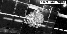
Satellites
The main contractor of the GLONASS program is Joint Stock Company Reshetnev Information Satellite Systems (formerly called NPO-PM). The company, located in ZheleznogorskZheleznogorsk, Krasnoyarsk Krai
Zheleznogorsk is a closed town in Krasnoyarsk Krai, Russia, with a developed nuclear industry. It was formerly known as Krasnoyarsk-26. Population: -History:...
, is the designer of all GLONASS satellites, in cooperation with the Institute for Space Device Engineering (:ru:РНИИ КП) and the Russian Institute of Radio Navigation and Time. Serial production of the satellites is accomplished by the company PC Polyot in Omsk
Omsk
-History:The wooden fort of Omsk was erected in 1716 to protect the expanding Russian frontier along the Ishim and the Irtysh rivers against the Kyrgyz nomads of the Steppes...
.
Over the three decades of development, the satellite designs have gone through numerous improvements, and can be divided into three generations: the original GLONASS (since 1982), GLONASS-M (since 2003) and GLONASS-K (since 2011). Each GLONASS satellite has a GRAU
Grau
Grau is a German word meaning "gray" and a Catalan word meaning "grade". It may refer to:* BAP Almirante Grau , a De Zeven Provinciën class cruiser in service with the Peruvian Navy* Grau Käse, Tyrolean grey cheese...
designation 11F654, and each of them also has the military "Cosmos-NNNN" designation.
First generation
The true first generation of GLONASS (also called UraganUragan
Uragan is the Slavic word for hurricane, and can refer to*BM-27 Uragan, a Russian rocket launcher*Energia II Uragan, a planned Soviet heavy-lift rocket*GLONASS satellites*MAZ-7310 Uragan, a Soviet/Russian army vehicle...
) satellites were all 3-axis stabilized vehicles, generally weighing 1,250 kg and were equipped with a modest propulsion system to permit relocation within the constellation. Over time they were upgraded to Block IIa, IIb, and IIv vehicles, with each block containing evolutionary improvements.
Six Block IIa satellites were launched in 1985–1986 with improved time and frequency standards over the prototypes, and increased frequency stability. These spacecraft also demonstrated a 16-month average operational lifetime. Block IIb spacecraft, with a 2-year design lifetimes, appeared in 1987, of which a total of 12 were launched, but half were lost in launch vehicle accidents. The six spacecraft that made it to orbit worked well, operating for an average of nearly 22 months.
Block IIv was the most prolific of the first generation. Used exclusively from 1988 to 2000, and continued to be included in launches through 2005, a total of 25 satellites were launched. The design life was three years, however numerous spacecraft exceeded this, with one late model lasting 68 months.
Block II satellites were typically launched three at a time from the Baikonur Cosmodrome
Baikonur Cosmodrome
The Baikonur Cosmodrome , also called Tyuratam, is the world's first and largest operational space launch facility. It is located in the desert steppe of Kazakhstan, about east of the Aral Sea, north of the Syr Darya river, near Tyuratam railway station, at 90 meters above sea level...
using Proton-K
Proton-K
The Proton-K, also designated Proton 8K82K after its GRAU index, 8K82K, is a Russian, previously Soviet, carrier rocket derived from the earlier Proton. It was built by Khrunichev, and is launched from sites 81 and 200 at the Baikonur Cosmodrome in Kazakhstan...
Blok-DM-2 or Proton-K Briz-M boosters. The only exception was when, on two launches, an Etalon geodetic reflector satellite was substituted for a GLONASS satellite.
Second generation
The second generation of satellites, known as Glonass-M, were developed beginning in 1990 and first launched in 2003. These satellites possess a substantially increased lifetime of seven years and weigh slightly more at 1,480 kg. They are approximately 2.4 m (8 ft) in diameter and 3.7 m (12 ft) high, with a solar array span of 7.2 m (24 ft) for an electrical power generation capability of 1600 watts at launch. The aft payload structure houses 12 primary antennas for L-band transmissions. Laser corner-cube reflectors are also carried to aid in precise orbit determination and geodetic research. On-board cesium clocksCaesium standard
A caesium standard or caesium atomic clock is a primary frequency standard in which electronic transitions between the two hyperfine ground states of caesium-133 atoms are used to control the output frequency. They are one of the most accurate types of atomic clock...
provide the local clock source.
A total of fourteen second generation satellites were launched through the end of 2007. As with the previous generation, the second generation spacecraft were launched in triplets using Proton-K
Proton rocket
Proton is an expendable launch system used for both commercial and Russian government space launches. The first Proton rocket was launched in 1965 and the launch system is still in use as of 2011, which makes it one of the most successful heavy boosters in the history of spaceflight...
Blok-DM-2 or Proton-K Briz-M boosters.
Third generation
GLONASS-K is a substantial improvement of the previous generation: it is the first unpressurised GLONASS satellite with a much reduced mass (750 kg versus 1,450 kg of GLONASS-M). It has an operational lifetime of 10 years, compared to the 7-year lifetime of the second generation GLONASS-M. It will transmit more navigation signals to improve the system's accuracy, including new CDMA signals in the L3 and L5 bands which will use modulation similar to modernized GPS, Galileo and Compass. The new satellite's advanced equipment—made solely from Russian components—will allow the doubling of GLONASS' accuracy. As with the previous satellites, these are 3-axis stabilized, nadirNadir
The nadir is the direction pointing directly below a particular location; that is, it is one of two vertical directions at a specified location, orthogonal to a horizontal flat surface there. Since the concept of being below is itself somewhat vague, scientists define the nadir in more rigorous...
pointing with dual solar arrays. The first GLONASS-K satellite was successfully launched on 26 February 2011.
Due to their weight reduction, GLONASS-K spacecraft can be launched in pairs from the Plesetsk Cosmodrome
Plesetsk Cosmodrome
Plesetsk Cosmodrome is a Russian spaceport, located in Arkhangelsk Oblast, about 800 km north of Moscow and approximately 200 km south of Arkhangelsk.-Overview:...
launch site using the substantially lower cost Soyuz-2.1b boosters or in six-at-once from the Baikonur Cosmodrome
Baikonur Cosmodrome
The Baikonur Cosmodrome , also called Tyuratam, is the world's first and largest operational space launch facility. It is located in the desert steppe of Kazakhstan, about east of the Aral Sea, north of the Syr Darya river, near Tyuratam railway station, at 90 meters above sea level...
using Proton-K Briz-M launch vehicles.
Ground control
The ground control segment of GLONASS is entirely located within former Soviet Union territory. The Ground Control Center and Time Standards is located in MoscowMoscow
Moscow is the capital, the most populous city, and the most populous federal subject of Russia. The city is a major political, economic, cultural, scientific, religious, financial, educational, and transportation centre of Russia and the continent...
and the telemetry and tracking stations are in Saint Petersburg
Saint Petersburg
Saint Petersburg is a city and a federal subject of Russia located on the Neva River at the head of the Gulf of Finland on the Baltic Sea...
, Ternopol, Eniseisk, and Komsomolsk-na-Amure.
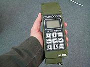
Receivers
SeptentrioSeptentrio
Septentrio is a designer and manufacturer of high-end multi-frequency GNSS receivers. Its main target is to provide GNSS receiver boards for further system integration by Original Equipment Manufacturers...
, Topcon
Topcon
Topcon is a Japanese manufacturer of optical equipment for ophthalmology and surveying. Their headquarters are in Itabashi, Tokyo. They are affiliated with Toshiba, which holds 40% of Topcon's stock.-History of Topcon:...
, JAVAD, Magellan Navigation
Magellan Navigation
Magellan Navigation, Inc. is a producer of consumer and professional grade global positioning system receivers. Headquartered in Santa Clara, California, with European sales and engineering centers in Nantes, France and Moscow, Russia, Magellan also produces aftermarket automotive GPS units,...
, Novatel, Leica Geosystems
Leica Geosystems
Leica Geosystems based in eastern Switzerland produces products and systems for surveying and geographical measurement...
and Trimble Inc
Trimble Inc
Trimble Navigation, Ltd. , based in Sunnyvale, California, is a provider of advanced positioning equipment, most notably GPS receivers, laser rangefinders and inertial navigation systems. The company is best known in the fields of surveying, construction, agriculture, scientific instrumentation,...
produce GNSS receivers making use of GLONASS. NPO Progress describes a receiver called "GALS-A1" which combines GPS and GLONASS reception. SkyWave Mobile Communications
SkyWave Mobile Communications
SkyWave Mobile Communications is a satellite telematics company that provides satellite transceivers, dual-mode satellite/GPRS terminals and satellite network services for global tracking, monitoring, and control of mobile and stationary assets...
manufactures an Inmarsat-based satellite communications terminal that uses both GLONASS and GPS. As of 2011, some of the latest receivers in the Garmin
Garmin
Garmin Ltd. , incorporated in Schaffhausen, Switzerland, is the parent company of a group of companies founded in 1989 by Gary Burrell and Min Kao , that develops consumer, aviation, and marine technologies for the Global Positioning System...
eTrex line also support GLONASS (along with GPS). Various smartphones
Smartphone
A smartphone is a high-end mobile phone built on a mobile computing platform, with more advanced computing ability and connectivity than a contemporary feature phone. The first smartphones were devices that mainly combined the functions of a personal digital assistant and a mobile phone or camera...
from 2011 onwards have integrated GLONASS capability, including devices from Sony Ericsson
Sony Ericsson
Sony Ericsson Mobile Communications AB is a joint venture established on October 1, 2001 by the Japanese consumer electronics company Sony Corporation and the Swedish telecommunications company Ericsson to manufacture mobile phones....
, ZTE
ZTE
ZTE Corporation formerly Zhongxing Telecommunication Equipment Corporation is a Chinese multinational telecommunications equipment and systems company headquartered in Shenzhen, China...
, Huawei
Huawei
Huawei is a Chinese multinational networking and telecommunications equipment and services company headquartered in Shenzhen, Guangdong, China...
, Samsung
Samsung
The Samsung Group is a South Korean multinational conglomerate corporation headquartered in Samsung Town, Seoul, South Korea...
, Apple and Motorola
Motorola
Motorola, Inc. was an American multinational telecommunications company based in Schaumburg, Illinois, which was eventually divided into two independent public companies, Motorola Mobility and Motorola Solutions on January 4, 2011, after losing $4.3 billion from 2007 to 2009...
; future support has been pledged by Nokia
Nokia
Nokia Corporation is a Finnish multinational communications corporation that is headquartered in Keilaniemi, Espoo, a city neighbouring Finland's capital Helsinki...
.
Availability
, the GLONASS constellation status is:| Total Satellites in Constellation | 31 SC |
|---|---|
| Operational | 23 SC (Glonass-M) |
| In Commissioning | 4 SC (Glonass-M) |
| In Flight-test | 1 SC (Glonass-K) |
| In Maintenance | 2 SC (Glonass-M) |
| Spare | 1 SC (Glonass-M) |
| In Decommissioning | – |
The system requires 18 satellites for continuous navigation services covering the entire territory of the Russian Federation, and 24 satellites to provide services worldwide. The GLONASS system currently covers 100% of Russian territory.
Accuracy
According to Russian System of Differentional Correction and Monitoring's data, , precisions of GLONASS navigation definitions (for p=0.95) for latitude and longitude were 4.46—7.38 m with mean number of NSV equals 7—8 (depending on station). In comparison, the same time precisions of GPS navigation definitions were 2.00—8.76 m with mean number of NSV equals 6—11 (depending on station). Civilian GLONASS used alone is therefore very slightly less accurate than GPS. On high latitudes (north or south), GLONASS' accuracy is better than that of GPS due to the orbital position of the satellites.Some modern receivers are able to use both GLONASS and GPS satellites together, providing greatly improved coverage in urban canyons and giving a very fast time to fix due to over 50 satellites being available. In indoor, urban canyon or mountainous areas, accuracy can be greatly improved over using GPS alone. For using both navigation systems simultaneously precisions of GLONASS/GPS navigation definitions were 2.37—4.65 m with mean number of NSV equals 14—19 (depends on station).
In May 2009, Anatoly Perminov
Anatoly Perminov
Dr. Prof. Anatoly Nikolayevich Perminov is a Russian rocket scientist and a mechanical engineer. He served as the General Director of Russian Federal Space Agency in 2004–2011.-Career:...
the then director of the Russian Federal Space Agency
Russian Federal Space Agency
The Russian Federal Space Agency , commonly called Roscosmos and abbreviated as FKA and RKA , is the government agency responsible for the Russian space science program and general aerospace research. It was previously the Russian Aviation and Space Agency .Headquarters of Roscosmos are located...
stated that actions were undertaken to expand GLONASS's constellation and to improve the ground segment in order to increase the navigation definition of GLONASS to an accuracy of 2.8 m by 2011. In particular, the latest satellite design, GLONASS-K
GLONASS-K
GLONASS-K is the latest satellite design intended as a part of the Russian GLONASS radio-based satellite navigation system. Developed by Reshetnev Information Satellite Systems and first launched on 26 February 2011, it is a substantial improvement of the previous GLONASS-M second-generation...
has the ability to double the system's accuracy once introduced.
See also
- Global navigation satellite systemGlobal Navigation Satellite SystemA satellite navigation or SAT NAV system is a system of satellites that provide autonomous geo-spatial positioning with global coverage. It allows small electronic receivers to determine their location to within a few metres using time signals transmitted along a line-of-sight by radio from...
– the generic phrase for a global satellite positioning system - MultilaterationMultilaterationMultilateration is a navigation technique based on the measurement of the difference in distance to two or more stations at known locations that broadcast signals at known times. Unlike measurements of absolute distance or angle, measuring the difference in distance results in an infinite number of...
– the mathematical technique used for positioning
External links
- Official GLONASS web page
- GNSS web page including GLONASS
- Description of GLONASS on the web page of the International Laser Ranging Service (ILRS)
- GLONASS: present, future and past Presented on the ILRS Technical Workshop, September 14–19, 2009, Metsovo, Greece
- A homemade receiver for GPS & GLONASS satellites