
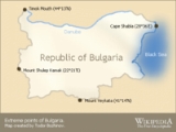
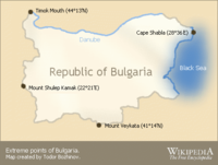
Extreme points of Bulgaria
Encyclopedia
Bulgaria
Bulgaria , officially the Republic of Bulgaria , is a parliamentary democracy within a unitary constitutional republic in Southeast Europe. The country borders Romania to the north, Serbia and Macedonia to the west, Greece and Turkey to the south, as well as the Black Sea to the east...
; and the highest and the lowest elevations in the country. Also included in this list is the southern-most Bulgaria station in Antarctica. With the exception of Cape Shabla
Shabla
Shabla is a town and seaside resort in northeastern Bulgaria, administrative centre of the homonymous municipality part of Dobrich Province. As of December 2009, the town has a population of 3,586 inhabitants...
, the eastern-most location of Bulgaria, all other extreme points are uninhabited.
The latitude and longitude are expressed in decimal degree notation, in which a positive latitude value refers to the northern hemisphere, and a negative value refers to the southern hemisphere. Similarly, a positive longitude value refers to the eastern hemisphere, and a negative value refers to the western hemisphere. The coordinates used in this article are sourced from Google Earth
Google Earth
Google Earth is a virtual globe, map and geographical information program that was originally called EarthViewer 3D, and was created by Keyhole, Inc, a Central Intelligence Agency funded company acquired by Google in 2004 . It maps the Earth by the superimposition of images obtained from satellite...
, which makes use of the World Geodetic System
World Geodetic System
The World Geodetic System is a standard for use in cartography, geodesy, and navigation. It comprises a standard coordinate frame for the Earth, a standard spheroidal reference surface for raw altitude data, and a gravitational equipotential surface that defines the nominal sea level.The latest...
(WGS) 84, a geodetic reference system.
Latitude and longitude
Timok River
The Timok is a river in eastern Serbia and for the last 15 km of its run a border between eastern Serbia and western Bulgaria.It derives the names in all these from the name it had in antiquity, Latin: Timacus....
flows into the Danube
Danube
The Danube is a river in the Central Europe and the Europe's second longest river after the Volga. It is classified as an international waterway....
. The northern tip of Bulgaria is located in the Vidin Province
Vidin Province
Vidin Province is the northwesternmost province of Bulgaria. It borders Serbia to the west and Romania to the northeast. Its administrative centre is the city of Vidin on the Danube river. The area is divided into 11 municipalities...
, and neighbours the Mehedinţi County
Mehedinti County
Mehedinţi is a county of Romania. It is mostly located in the historical province of Oltenia, with one municipality and three communes located in the Banat...
of Romania
Romania
Romania is a country located at the crossroads of Central and Southeastern Europe, on the Lower Danube, within and outside the Carpathian arch, bordering on the Black Sea...
. The closest Bulgarian village to that area is Vrav
Vrav
Vrav is a village in northwestern Bulgaria, part of Bregovo municipality, Vidin Province. Located on the right bank of the Danube at the place where the Timok River empties into it, Vrav is the northernmost populated place in Bulgaria and the first Bulgarian port along the Danube's course...
. Bulgaria's most southern point is in the Kardzhali Province
Kardzhali Province
Kardzhali Province is a province of southern Bulgaria, neighbouring Greece with the Greek prefectures of Xanthi, Rhodope and Evros to the south and east. Kardzhali Province area is 3209.1 km². Its main city is Kardzhali.-History:...
's Mount Veykata. At 1463 metres (4,799.9 ft), Veykata is the highest Bulgarian peak of the Gyumyurdzhinski Snezhnik ridge in the Eastern Rhodope Mountains
Rhodope Mountains
The Rhodopes are a mountain range in Southeastern Europe, with over 83% of its area in southern Bulgaria and the remainder in Greece. Its highest peak, Golyam Perelik , is the seventh highest Bulgarian mountain...
, and borders the East Macedonia and Thrace
East Macedonia and Thrace
East Macedonia and Thrace is one of the thirteen regions of Greece. It consists of the northeastern parts of the country, comprising the eastern part of the region of Macedonia along with the region of Thrace, and the islands of Thasos and Samothrace....
periphery
Peripheries of Greece
The current official regional administrative divisions of Greece were instituted in 1987. Although best translated into English as "regions", the transcription peripheries is sometimes used, perhaps to distinguish them from the traditional regions which they replaced. The English word 'periphery'...
of Greece
Greece
Greece , officially the Hellenic Republic , and historically Hellas or the Republic of Greece in English, is a country in southeastern Europe....
. Bulgaria's western-most point is in Mount Shulep Kamak of the Chudintsi Mountain, standing at 1337 m (4,386.5 ft). This is the point where the Kyustendil Province
Kyustendil Province
-Religion:Religious adherence in the province according to 2001 census:-Language:Mother tongues in the province according to 2001 census:* 153,242 Bulgarian * 7,929 Roma * 1363 others and unspecified -Ethnic groups:...
borders both the Pčinja District
Pcinja District
The Pčinja District expands to the southern parts of Serbia, bordering Bulgaria and the Republic of Macedonia. Its seat is in the city of Vranje....
of Central Serbia
Central Serbia
Central Serbia , also referred to as Serbia proper , was the region of Serbia from 1945 to 2009. It included central parts of Serbia outside of the autonomous provinces of Kosovo and Vojvodina. The region of Central Serbia was not an administrative division of Serbia as such; it was under the...
and the Kriva Palanka municipality
Kriva Palanka municipality
Kriva Palanka is a municipality in eastern Republic of Macedonia. Kriva Palanka is also the name of the town where the municipal seat is found...
of Northeastern Macedonia
Northeastern statistical region
The Northeastern Statistical Region is one of eight arbitrary statistical regions in the Republic of Macedonia. Northeastern, located in the northeastern part of the country, borders Serbia and Bulgaria...
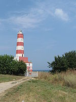
. Cape Shabla
Shabla
Shabla is a town and seaside resort in northeastern Bulgaria, administrative centre of the homonymous municipality part of Dobrich Province. As of December 2009, the town has a population of 3,586 inhabitants...
is Bulgaria's eastern-most point; it lies in the Dobrich Province
Dobrich Province
Dobrich Province is a province in northeastern Bulgaria, part of Southern Dobruja geographical region. It is divided into 8 municipalities with a total population, as of December 2009, of 199,705 inhabitants.-Municipalities:...
, on the country's Black Sea
Black Sea
The Black Sea is bounded by Europe, Anatolia and the Caucasus and is ultimately connected to the Atlantic Ocean via the Mediterranean and the Aegean seas and various straits. The Bosphorus strait connects it to the Sea of Marmara, and the strait of the Dardanelles connects that sea to the Aegean...
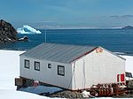
outlet. Also included in this table is St. Kliment Ohridski Base
St. Kliment Ohridski Base
St. Kliment Ohridski Base is a Bulgarian Antarctic base on Livingston Island in the South Shetland Islands.The base, originally known as Sofia University Refuge, was named in 1993 "for St...
, Bulgaria's station in Antarctica.
| Heading | Location | Province | Bordering entity | CoordinatesCoordinates obtained from Google Earth Google Earth Google Earth is a virtual globe, map and geographical information program that was originally called EarthViewer 3D, and was created by Keyhole, Inc, a Central Intelligence Agency funded company acquired by Google in 2004 . It maps the Earth by the superimposition of images obtained from satellite... . Google Earth makes use of the WGS84 World Geodetic System The World Geodetic System is a standard for use in cartography, geodesy, and navigation. It comprises a standard coordinate frame for the Earth, a standard spheroidal reference surface for raw altitude data, and a gravitational equipotential surface that defines the nominal sea level.The latest... geodetic reference system. |
Ref |
|---|---|---|---|---|---|
| North | The Timok Timok River The Timok is a river in eastern Serbia and for the last 15 km of its run a border between eastern Serbia and western Bulgaria.It derives the names in all these from the name it had in antiquity, Latin: Timacus.... 's mouth into the Danube |
Vidin Vidin Province Vidin Province is the northwesternmost province of Bulgaria. It borders Serbia to the west and Romania to the northeast. Its administrative centre is the city of Vidin on the Danube river. The area is divided into 11 municipalities... |
Mehedinţi County Mehedinti County Mehedinţi is a county of Romania. It is mostly located in the historical province of Oltenia, with one municipality and three communes located in the Banat... , Romania Romania Romania is a country located at the crossroads of Central and Southeastern Europe, on the Lower Danube, within and outside the Carpathian arch, bordering on the Black Sea... |
44.214555°N 22.67459°W | |
| South | Mount Veykata | Kardzhali Kardzhali Province Kardzhali Province is a province of southern Bulgaria, neighbouring Greece with the Greek prefectures of Xanthi, Rhodope and Evros to the south and east. Kardzhali Province area is 3209.1 km². Its main city is Kardzhali.-History:... |
East Macedonia and Thrace East Macedonia and Thrace East Macedonia and Thrace is one of the thirteen regions of Greece. It consists of the northeastern parts of the country, comprising the eastern part of the region of Macedonia along with the region of Thrace, and the islands of Thasos and Samothrace.... , Greece Greece Greece , officially the Hellenic Republic , and historically Hellas or the Republic of Greece in English, is a country in southeastern Europe.... |
41.236022°N 25.288167°W | |
| South (Antarctica) | St. Kliment Ohridski Base St. Kliment Ohridski Base St. Kliment Ohridski Base is a Bulgarian Antarctic base on Livingston Island in the South Shetland Islands.The base, originally known as Sofia University Refuge, was named in 1993 "for St... |
Antarctica | N/A | 62.641389°N 60.364722°W | |
| West | Mount Shulep Kamak | Kyustendil Kyustendil Province -Religion:Religious adherence in the province according to 2001 census:-Language:Mother tongues in the province according to 2001 census:* 153,242 Bulgarian * 7,929 Roma * 1363 others and unspecified -Ethnic groups:... |
Pčinja District Pcinja District The Pčinja District expands to the southern parts of Serbia, bordering Bulgaria and the Republic of Macedonia. Its seat is in the city of Vranje.... , Central Serbia Central Serbia Central Serbia , also referred to as Serbia proper , was the region of Serbia from 1945 to 2009. It included central parts of Serbia outside of the autonomous provinces of Kosovo and Vojvodina. The region of Central Serbia was not an administrative division of Serbia as such; it was under the... , Serbia Serbia Serbia , officially the Republic of Serbia , is a landlocked country located at the crossroads of Central and Southeast Europe, covering the southern part of the Carpathian basin and the central part of the Balkans... and Kriva Palanka Kriva Palanka municipality Kriva Palanka is a municipality in eastern Republic of Macedonia. Kriva Palanka is also the name of the town where the municipal seat is found... , Northeastern Macedonia Northeastern statistical region The Northeastern Statistical Region is one of eight arbitrary statistical regions in the Republic of Macedonia. Northeastern, located in the northeastern part of the country, borders Serbia and Bulgaria... , Republic of Macedonia Republic of Macedonia Macedonia , officially the Republic of Macedonia , is a country located in the central Balkan peninsula in Southeast Europe. It is one of the successor states of the former Yugoslavia, from which it declared independence in 1991... |
42.312700°N 22.360067°W | |
| East | Cape Shabla Shabla Shabla is a town and seaside resort in northeastern Bulgaria, administrative centre of the homonymous municipality part of Dobrich Province. As of December 2009, the town has a population of 3,586 inhabitants... |
Dobrich Dobrich Province Dobrich Province is a province in northeastern Bulgaria, part of Southern Dobruja geographical region. It is divided into 8 municipalities with a total population, as of December 2009, of 199,705 inhabitants.-Municipalities:... |
Black Sea Black Sea The Black Sea is bounded by Europe, Anatolia and the Caucasus and is ultimately connected to the Atlantic Ocean via the Mediterranean and the Aegean seas and various straits. The Bosphorus strait connects it to the Sea of Marmara, and the strait of the Dardanelles connects that sea to the Aegean... |
43.539550°N 28.607050°W |
Extreme elevation
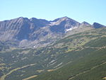
Musala
Musala is the highest peak in Bulgaria and the entire Balkan Peninsula, standing at 2,925 m . The summit of the Rila mountain in southwestern Bulgaria, Musala is the highest peak between the Alps and the Caucasus and the highest in Eastern Europe bar the Caucasus.Between 1949–1962 the peak was...
, which, standing at 2925.4 m (9,598 ft), is located in the Rila National Park. Musala is part of the Rila
Rila
Rila is a mountain range in southwestern Bulgaria and the highest mountain range of Bulgaria and the Balkans, with its highest peak being Musala at 2,925 m...
mountain range in the Sofia Province
Sofia Province
Sofia Province is a province of Bulgaria. The province does not include Sofia in its territories, but Sofia however remains its administrative center...
.In addition to being Bulgaria's highest point, Musala is also taller than any other peak in the Balkans
Balkans
The Balkans is a geopolitical and cultural region of southeastern Europe...
. Other peaks of comparable height in the vicinity of Musala include Little Musala, standing at 2902 m (9,521 ft), and Irechek, which is 2852 m (9,357 ft). Bulgaria's lowest point is located on the coast, with its outlet on the Black Sea
Bulgarian Black Sea Coast
The Bulgarian Black Sea Coast covers the entire eastern bound of Bulgaria stretching from the Romanian Black Sea resorts in the north to European Turkey in the south, along 378 km of coastline. White and golden sandy beaches occupy approximately 130 km of the 378 km long coast...
. The region stays steady at sea level
Sea level
Mean sea level is a measure of the average height of the ocean's surface ; used as a standard in reckoning land elevation...
, and stretches 354 km (220 mi), from the Romanian Black Sea Riviera
Romanian Black Sea resorts
The Romanian Black Sea resorts stretches from Danube Delta in north down to the Bulgarian Black Sea Coast in south, along 275 km of coastline....
to Turkey
Turkey
Turkey , known officially as the Republic of Turkey , is a Eurasian country located in Western Asia and in East Thrace in Southeastern Europe...
's Marmara Region
Marmara Region
The Marmara Region , with a surface area of 67.000 km², is the smallest but most densely populated of the seven geographical regions of Turkey...
.
| Extremity | Name | Elevation | Location | Province | Coordinates | Ref |
|---|---|---|---|---|---|---|
| Highest | Mount Musala Musala Musala is the highest peak in Bulgaria and the entire Balkan Peninsula, standing at 2,925 m . The summit of the Rila mountain in southwestern Bulgaria, Musala is the highest peak between the Alps and the Caucasus and the highest in Eastern Europe bar the Caucasus.Between 1949–1962 the peak was... |
2925.4 m (9,598 ft) | Rila Rila Rila is a mountain range in southwestern Bulgaria and the highest mountain range of Bulgaria and the Balkans, with its highest peak being Musala at 2,925 m... Mountain, Sofia Province Sofia Province Sofia Province is a province of Bulgaria. The province does not include Sofia in its territories, but Sofia however remains its administrative center... |
Sofia Sofia Province Sofia Province is a province of Bulgaria. The province does not include Sofia in its territories, but Sofia however remains its administrative center... |
42.1047°N 23.3512°E | |
| Lowest | Black Sea Black Sea The Black Sea is bounded by Europe, Anatolia and the Caucasus and is ultimately connected to the Atlantic Ocean via the Mediterranean and the Aegean seas and various straits. The Bosphorus strait connects it to the Sea of Marmara, and the strait of the Dardanelles connects that sea to the Aegean... |
0 m (0 ft) | Bulgarian Black Sea Coast Bulgarian Black Sea Coast The Bulgarian Black Sea Coast covers the entire eastern bound of Bulgaria stretching from the Romanian Black Sea resorts in the north to European Turkey in the south, along 378 km of coastline. White and golden sandy beaches occupy approximately 130 km of the 378 km long coast... |
Dobrich Dobrich Province Dobrich Province is a province in northeastern Bulgaria, part of Southern Dobruja geographical region. It is divided into 8 municipalities with a total population, as of December 2009, of 199,705 inhabitants.-Municipalities:... , Varna, and Burgas Burgas Province -Municipalities:The Burgas province contains 13 municipalities . The following table shows the names of each municipality in English and Cyrillic, the main town or village , and the population of each as of 2009.-Demography:The Burgas province had a population of 423,608 -Municipalities:The Burgas... |
43.5°N 34.5°E |
See also
- Extreme points of EuropeExtreme points of EuropeThis is a list of the extreme points of Europe: the geographical points that are higher, farther north, south, east or west than any other location in Europe. Some of these positions are open to debate, as the definition of Europe is diverse....
- Extreme points of Earth
- Geography of BulgariaGeography of BulgariaBulgaria is a country situated in south-eastern Europe, bordering Romania, Serbia, the Republic of Macedonia, Greece, Turkey and the Black Sea. Its northern border with Romania follows the Danube river until Silistra. The land area of Bulgaria is 110,550 square kilometers, slightly larger than that...