
Timok River
Encyclopedia
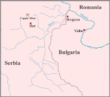
The Timok is a river
in eastern Serbia
and for the last 15 km of its run a border between eastern Serbia and western Bulgaria
.
It derives the names in all these from the name it had in antiquity, Latin
: Timacus.
It is a very branchy system of many shorter rivers, a large number of them having the same name (Timok), only clarified with adjectives. From the farthest source in the system, that of the Svrljiški Timok, until its confluence into the Danube
(as Veliki Timok), the Timok is 203 km long. The river flows through Serbia and for the last 15 km forms the border between Serbia and Bulgaria. The area of the river basin is 4,630 km². The Timok Valley is known for the most important Romanian-speaking population in Eastern Serbia.
Timok Cove
in Rugged Island
in the South Shetland Islands
, Antarctica is named after Timok River.
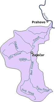 The Timok, also named Veliki Timok to distinguish it from its tributaries, is formed by the confluence of the rivers Beli Timok ("White Timok") and Crni Timok ("Black Timok") at Zaječar
. The Beli Timok is formed by the confluence of the rivers Svrljiški Timok ("Svrljig
Timok") and Trgoviški Timok ("Trgovište
Timok") at Knjaževac
.
Tributaries of the Timok are Duboki Dol, Beslarica, Golami Dol, Kijevska, Bračevicka, Studena Voda, Pivnica and Eleshchev from the right, and Lipovička River, Crna reka, Jelašnička reka, Salaška reka
, Ogašu Taba, Brusnički potok, Urovički potok, Plandište and Sikolska river from the left.
, Trnavac, Čokonjar, and Brusnik. Passing between the last two it leaves Timočka Krajina and enters Negotinska Krajina.
In the lower course the Timok has no major settlements on the Serbian side (though flowing only 7 km from Negotin
). Some 15 km before it empties into the Danube as its right tributary, the Timok becomes a border river, passing next to the Bulgarian town of Bregovo
and the Bulgarian village of Baley. The river's mouth represents the northernmost point of Bulgaria, and is only 28 m above sea level, which makes it the lowest point of Serbia. The average discharge is 24 m³/s, but it can grow to 40 m³/s, and the Timok is part of the Black Sea
drainage basin. The main (right) tributaries in this section are Crna reka, Salaška reka, Sikolska reka and Čubarska reka (Cyrillic: Црна река, Салашка река, Сиколска река and Чубарска река).
Apart from Timočka Krajina, the Timok gave its name to a rebellion against Serbian king Milan Obrenović IV
in 1883, Timočka buna ("rebellion of Timok").
The river has been greatly ecologically damaged in recent years by the mining
and heavy metal
industry
in Bor and Krivelj
and is consequently polluting the Danube with lead
, copper
and cadmium
.
The river valley is a natural route for the road and railway Niš
-Prahovo
.
River
A river is a natural watercourse, usually freshwater, flowing towards an ocean, a lake, a sea, or another river. In a few cases, a river simply flows into the ground or dries up completely before reaching another body of water. Small rivers may also be called by several other names, including...
in eastern Serbia
Serbia
Serbia , officially the Republic of Serbia , is a landlocked country located at the crossroads of Central and Southeast Europe, covering the southern part of the Carpathian basin and the central part of the Balkans...
and for the last 15 km of its run a border between eastern Serbia and western Bulgaria
Bulgaria
Bulgaria , officially the Republic of Bulgaria , is a parliamentary democracy within a unitary constitutional republic in Southeast Europe. The country borders Romania to the north, Serbia and Macedonia to the west, Greece and Turkey to the south, as well as the Black Sea to the east...
.
It derives the names in all these from the name it had in antiquity, Latin
Latin
Latin is an Italic language originally spoken in Latium and Ancient Rome. It, along with most European languages, is a descendant of the ancient Proto-Indo-European language. Although it is considered a dead language, a number of scholars and members of the Christian clergy speak it fluently, and...
: Timacus.
It is a very branchy system of many shorter rivers, a large number of them having the same name (Timok), only clarified with adjectives. From the farthest source in the system, that of the Svrljiški Timok, until its confluence into the Danube
Danube
The Danube is a river in the Central Europe and the Europe's second longest river after the Volga. It is classified as an international waterway....
(as Veliki Timok), the Timok is 203 km long. The river flows through Serbia and for the last 15 km forms the border between Serbia and Bulgaria. The area of the river basin is 4,630 km². The Timok Valley is known for the most important Romanian-speaking population in Eastern Serbia.
Timok Cove
Timok Cove
Timok Cove is a 580 m wide cove indenting for 400 m the north coast of Rugged Island off the west coast of Byers Peninsula of Livingston Island in the South Shetland Islands, Antarctica, and entered west of Simitli Point....
in Rugged Island
Rugged Island (South Shetland Islands)
Rugged Island is an island long and wide, lying west of Livingston Island in the South Shetland Islands. Surface area . The island's summit San Stefano Peak rises to above sea level. Rugged Island is located at...
in the South Shetland Islands
South Shetland Islands
The South Shetland Islands are a group of Antarctic islands, lying about north of the Antarctic Peninsula, with a total area of . By the Antarctic Treaty of 1959, the Islands' sovereignty is neither recognized nor disputed by the signatories and they are free for use by any signatory for...
, Antarctica is named after Timok River.
Drainage system
Zajecar
Zaječar is a city and municipality in the eastern part of Serbia. According to the 2011 census the town has a population of 36,830, and its coordinates are 43.91° North, 22.30° East...
. The Beli Timok is formed by the confluence of the rivers Svrljiški Timok ("Svrljig
Svrljig
Svrljig is a town and municipality located in the Nišava District of Serbia. According to 2011 census, the town has a population of 7,543 inhabitants, while the municipality has 14,224.-Geography:...
Timok") and Trgoviški Timok ("Trgovište
Trgovište (Knjaževac)
Trgovište is a village in the municipality of Knjaževac, Serbia. According to the 2002 census, the village has a population of 1953 people....
Timok") at Knjaževac
Knjaževac
Knjaževac is a town and municipality situated in the eastern part of Serbia bordering the Republic of Bulgaria and is part of Timočka Krajina region. It is found between the latitudes of 43°20' and 43°45' north and between the longitudes 22°11' and 22°41' east. The town is situated between three...
.
Tributaries of the Timok are Duboki Dol, Beslarica, Golami Dol, Kijevska, Bračevicka, Studena Voda, Pivnica and Eleshchev from the right, and Lipovička River, Crna reka, Jelašnička reka, Salaška reka
Salas River
The Sălaş River is a tributary of the Strei River in Romania.-References:* Administraţia Naţională Apelor Române - Cadastrul Apelor - Bucureşti* Institutul de Meteorologie şi Hidrologie - Rîurile României - Bucureşti 1971-Maps:...
, Ogašu Taba, Brusnički potok, Urovički potok, Plandište and Sikolska river from the left.
Course
The Timok turns north-west after its formation at Zaječar, running next to the villages of VražogrnacVražogrnac
Vražogrnac is a village in the municipality of Zaječar, Serbia. According to the 2002 census, the village has a population of 1340 people....
, Trnavac, Čokonjar, and Brusnik. Passing between the last two it leaves Timočka Krajina and enters Negotinska Krajina.
In the lower course the Timok has no major settlements on the Serbian side (though flowing only 7 km from Negotin
Negotin
Negotin is a town and municipality in the Bor District of north-eastern Central Serbia. It is situated near the borders between Serbia, Romania and Bulgaria. It is the judicial center of the Bor District. The population of the town is 16,716 while municipality has 36,879.-Name:The etymology of the...
). Some 15 km before it empties into the Danube as its right tributary, the Timok becomes a border river, passing next to the Bulgarian town of Bregovo
Bregovo
Bregovo is a town in the very northwest of Bulgaria, situated on the east bank of the Timok River close to its mouth. It is the administrative centre of the homonymous Bregovo Municipality, Vidin Province. The town is located close to the city of Vidin near the national border crossings with...
and the Bulgarian village of Baley. The river's mouth represents the northernmost point of Bulgaria, and is only 28 m above sea level, which makes it the lowest point of Serbia. The average discharge is 24 m³/s, but it can grow to 40 m³/s, and the Timok is part of the Black Sea
Black Sea
The Black Sea is bounded by Europe, Anatolia and the Caucasus and is ultimately connected to the Atlantic Ocean via the Mediterranean and the Aegean seas and various straits. The Bosphorus strait connects it to the Sea of Marmara, and the strait of the Dardanelles connects that sea to the Aegean...
drainage basin. The main (right) tributaries in this section are Crna reka, Salaška reka, Sikolska reka and Čubarska reka (Cyrillic: Црна река, Салашка река, Сиколска река and Чубарска река).
Apart from Timočka Krajina, the Timok gave its name to a rebellion against Serbian king Milan Obrenović IV
Milan Obrenovic IV
Milan Obrenović was a Serbian monarch reigning as Prince Milan IV of Serbia from 1868 to 1882 and King Milan I of Serbia from 1882 to 1889.-Early years:...
in 1883, Timočka buna ("rebellion of Timok").
Economy and ecology
At Čokonjar, the Sokolovica power plant was constructed in 1947-1951. Opportunities for higher electricity production are not used.The river has been greatly ecologically damaged in recent years by the mining
Mining
Mining is the extraction of valuable minerals or other geological materials from the earth, from an ore body, vein or seam. The term also includes the removal of soil. Materials recovered by mining include base metals, precious metals, iron, uranium, coal, diamonds, limestone, oil shale, rock...
and heavy metal
Heavy metals
A heavy metal is a member of a loosely-defined subset of elements that exhibit metallic properties. It mainly includes the transition metals, some metalloids, lanthanides, and actinides. Many different definitions have been proposed—some based on density, some on atomic number or atomic weight,...
industry
Industry
Industry refers to the production of an economic good or service within an economy.-Industrial sectors:There are four key industrial economic sectors: the primary sector, largely raw material extraction industries such as mining and farming; the secondary sector, involving refining, construction,...
in Bor and Krivelj
Krivelj
Krivelj is a village in the municipality of Bor, Serbia. According to the 2002 census, the village has a population of 1316 people.-References:...
and is consequently polluting the Danube with lead
Lead
Lead is a main-group element in the carbon group with the symbol Pb and atomic number 82. Lead is a soft, malleable poor metal. It is also counted as one of the heavy metals. Metallic lead has a bluish-white color after being freshly cut, but it soon tarnishes to a dull grayish color when exposed...
, copper
Copper
Copper is a chemical element with the symbol Cu and atomic number 29. It is a ductile metal with very high thermal and electrical conductivity. Pure copper is soft and malleable; an exposed surface has a reddish-orange tarnish...
and cadmium
Cadmium
Cadmium is a chemical element with the symbol Cd and atomic number 48. This soft, bluish-white metal is chemically similar to the two other stable metals in group 12, zinc and mercury. Similar to zinc, it prefers oxidation state +2 in most of its compounds and similar to mercury it shows a low...
.
The river valley is a natural route for the road and railway Niš
Niš
Niš is the largest city of southern Serbia and third-largest city in Serbia . According to the data from 2011, the city of Niš has a population of 177,972 inhabitants, while the city municipality has a population of 257,867. The city covers an area of about 597 km2, including the urban area,...
-Prahovo
Prahovo
Prahovo is a village in the municipality of Negotin, Serbia. According to the 2002 census, the village has a population of 1506 people.The village is located on the Danube. Nearby sections of the river are crowded with German shipwrecks sunk in late 1944 to block passage to the Soviets....
.