
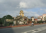
Dong Hoi
Encyclopedia
Quang Binh Province
Quảng Bình , formerly Tiên Bình under the reign of Le Trung Hung of the Lê Dynasty, this province was renamed Quảng Bình in 1604) is a province in the North Central Coast of Vietnam....
, in the north central coast
Bac Trung Bo
Bắc Trung Bộ is one of the regions of Vietnam. It consists of six provinces: Thanh Hóa, Nghệ An, Hà Tĩnh, Quảng Bình, Quảng Trị, Thừa Thiên-Huế...
of Vietnam
Vietnam
Vietnam – sometimes spelled Viet Nam , officially the Socialist Republic of Vietnam – is the easternmost country on the Indochina Peninsula in Southeast Asia. It is bordered by China to the north, Laos to the northwest, Cambodia to the southwest, and the South China Sea –...
. The city’s area is 155.71 km² (60.1 sq mi), population as per the 2009 census: 108,526. Urban area is 55.47 km², urban population was 71,620; Suburban area is 100.24 square kilometers, suburban population was 36,906. The city is served by the Dong Hoi Railway Station
Dong Hoi Railway Station
Dong Hoi Railway Station is one of the main railway stations on the North-South Railway in Vietnam. It serves the city of Đồng Hới, the provincial capital of Quang Binh Province. The station is 450 km south of Hanoi, 160 km north of Huế, 1280 km north of Saigon Railway Station.The...
, National Highway 1A and Dong Hoi Airport
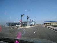
Dong Hoi Airport
Dong Hoi Airport is an airport located in Loc Ninh commune, 6 km north of Dong Hoi city, capital of Quang Binh province, in North Central Coast of Vietnam, 500 km South-east of Hanoi by road. The facilities cover 173 ha, on a sandy area, by the coast of South China Sea...
.
By the road, Đồng Hới is 486 kilometres (302 mi) south of Hanoi
Hanoi
Hanoi , is the capital of Vietnam and the country's second largest city. Its population in 2009 was estimated at 2.6 million for urban districts, 6.5 million for the metropolitan jurisdiction. From 1010 until 1802, it was the most important political centre of Vietnam...
, 195 kilometres (121.2 mi) south of Vinh
Vinh
Vinh is a city in Vietnam. It is located in the northern half of the country, and is the capital of Nghệ An Province. Politically, Vinh is a municipality within Nghệ An Province. On September 5th, 2008, it was upgraded from Grade-II city to Grade-I city, the fourth Grade-I city of Vietnam after...
, 172 kilometres (106.9 mi) north of Huế
Hue
Hue is one of the main properties of a color, defined technically , as "the degree to which a stimulus can be describedas similar to or different from stimuli that are described as red, green, blue, and yellow,"...
and 1238 kilometres (769.3 mi) north of Ho Chi Minh City
Ho Chi Minh City
Ho Chi Minh City , formerly named Saigon is the largest city in Vietnam...
. It borders Quảng Ninh District on the west and south, the South China Sea
South China Sea
The South China Sea is a marginal sea that is part of the Pacific Ocean, encompassing an area from the Singapore and Malacca Straits to the Strait of Taiwan of around...
on the east, Bố Trạch District on the north.
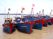
Dong Hoi has 12-km-long coastline with white sand beaches. Đồng Hới is the closest city to Phong Nha-Ke Bang National Park, UNESCO
UNESCO
The United Nations Educational, Scientific and Cultural Organization is a specialized agency of the United Nations...
’s World Natural Heritage Site
World Heritage Site
A UNESCO World Heritage Site is a place that is listed by the UNESCO as of special cultural or physical significance...
located 50 km north of the city.
History
Archaeological excavation in this area proved that human living in what is now Quảng Bình province in the Stone AgeStone Age
The Stone Age is a broad prehistoric period, lasting about 2.5 million years , during which humans and their predecessor species in the genus Homo, as well as the earlier partly contemporary genera Australopithecus and Paranthropus, widely used exclusively stone as their hard material in the...
period. Many artifacts, such as ceramic vases, stone tools, and china, have been unearthed in Quang Binh.
In 1926, a French female archaeologist, Madeleine Colani
Madeleine Colani
Madeleine Colani was a female French archaeologist, born in Strasbourg.In 1899, she arrived to Vietnam to teach, in 1914 returned to France to earn her doctorate. From 1920 - 1927, she worked for Indo-chinese geology bureau. She contributed much for Vietnamese archaeology, especially Sa Huỳnh...
discovered and excavated many artifacts in caves and grottoes in west mountainous areas of Quang Binh. She concluded that there existed the Hòa Bình culture
Hoabinhian
The term Hoabinhian was first used by French archaeologists working in Northern Vietnam to describe Holocene period archaeological assemblages excavated from rock shelters. It has become a common term in the English based literature to describe stone artifact assemblages in Southeast Asia that...
in this region. Through C14 dating test, the artifacts here dated back to 10,509 (plus or minus 950) ago.
From Quy Dat township (Tuyên Hóa
Tuyen Hoa
Tuyên Hóa is a district of Quang Binh Province in the North Central Coast region of Vietnam. Its seat is the town of Đồng Lê. Speakers of the Nguồn language are mostly located near Đồng Lê. As of 2003 the district had a population of . The district covers an area of 1,149 km²...
) to southwest about 150 m, the Hum grotto contains many stone tools and animal stones from an ancient human community. Inside Khai grotto near Quy Dat township, similar artifacts were also found. Especially, there are several ceramic of Dong Son culture
Dong Son culture
The Đông Sơn culture was a prehistoric Bronze Age age in Vietnam centered at the Red River Valley of northern Vietnam. At this time the first Vietnamese kingdoms of Văn Lang and Âu Lạc appeared...
.
Additionally, artifacts of the Stone Age period were also unearthed in some grottoes in Quang Binh region. Owners of these artifacts lived in the caves and grottoes and hunted for their food.
Human settlement in Đồng Hới can be traced to 5,000 years ago. Many relics and remnants have been found by the Vietnamese and French archaeologists in Bau Tro, a lake in the city. Most of the finds here belong to the Stone Age
Stone Age
The Stone Age is a broad prehistoric period, lasting about 2.5 million years , during which humans and their predecessor species in the genus Homo, as well as the earlier partly contemporary genera Australopithecus and Paranthropus, widely used exclusively stone as their hard material in the...
period. Around 2880 BC, the site of modern Đồng Hới was a territory of Viet Thuong tribe of Văn Lang
Van Lang
Văn Lang was, according to tradition, the first nation of the ancient Vietnamese people, founded in 2879 BC and existing until 258 BC. It was ruled by the Hùng Kings of the Hồng Bàng Dynasty. There is, however, little reliable historical information available...
(Vietnam) during the reign of king Hùng Vương
Hung Vuong
Hùng Vương is a title used in many modern discussions of the ancient Vietnamese rulers of the Hồng Bàng) period. In antiquity this title began to be used for the ruler who was the religious and political leader of united ancient Vietnam...
. The site was long a disputed territory between the Champa kingdom
Champa
The kingdom of Champa was an Indianized kingdom that controlled what is now southern and central Vietnam from approximately the 7th century through to 1832.The Cham people are remnants...
and Đại Việt. It officially became Đại Việt territory in 1069 after Ly Thuong Kiet took victory over Champa
Champa
The kingdom of Champa was an Indianized kingdom that controlled what is now southern and central Vietnam from approximately the 7th century through to 1832.The Cham people are remnants...
in this area as a result of Dai Viet-Champa War. The area ceased to be the southernmost of Dai Viet after the political marriage of the Trần Dynasty princess, Huyền Trân
Huyen Tran
Princess Huyền Trân , was a princess during the Trần Dynasty in the history of Vietnam. She was the daughter of Emperor Trần Nhân Tông and the younger sister of Emperor Trần Anh Tông...
, to Champa king, Jaya Sinhavarman III (Vietnamese: Chế Mân). Princess Huyền Trân was king Trần Nhân Tông's daughter and king Trần Anh Tông's younger sister. Political matches made to acquire land was a traditional practice by Champa kings. Thanks to this marriage, Đại Việt acquired lands (as dowry) of what is now Quảng Trị Province
Quang Tri Province
Quảng Trị is a province on the North Central Coast of Vietnam, north of the former imperial capital of Huế.-Geography:Located in North Central Vietnam, Quang Tri Province is surrounded by Quang Binh Province on the north, Thua Thien-Hue Province on the south, Savannakhet Province of Laos on the...
, and Thua Thien-Hue Province
Thua Thien-Hue Province
Thừa Thiên-Huế is a province in the North Central Coast of Vietnam, approximately in the center of the country. It borders Quang Tri Provice to the north and Da Nang City to the south, Laos to the west and the South China Sea to the east. The province has 128 km of coastline, 22,000 ha of...
(provinces which were then known respectively as Chau O and Chau Ri or Chau Ly).
During the time of the Trịnh-Nguyễn War (1558–1775), Vietnam was divided into two countries: Dang Trong (South) and Dang Ngoai (North) with the Gianh River
Gianh River
The Gianh River is a river in the Quang Binh Province of Vietnam's North Central Coast . The river is 268 km in length.It was the border between ruling families during the partition of Vietnam following the Trịnh-Nguyễn War of the 17th century, serving to effectively divide the country between...
as frontier line. Đồng Hới was an important fortress of the southern Nguyễn Lords. The Đồng Hới Wall (Vietnamese: Thành Đồng Hới) was considered the barrier which protected the Nguyễn Lords from the attack by northern Trịnh family. During the Indochina War (between the French and the Viet Minh
Viet Minh
Việt Minh was a national independence coalition formed at Pac Bo on May 19, 1941. The Việt Minh initially formed to seek independence for Vietnam from the French Empire. When the Japanese occupation began, the Việt Minh opposed Japan with support from the United States and the Republic of China...
in 1950s), the Đồng Hới airbase was used by the French to attack both the Viet Minh in north-central Vietnam and the Laotian Pathet Lao Army
Pathet Lao
The Pathet Lao was a communist political movement and organization in Laos, formed in the mid-20th century. The group was ultimately successful in assuming political power after the Laotian Civil War. The Pathet Lao were always closely associated with Vietnamese communists...
in central and southern Laos. During the Vietnam War
Vietnam War
The Vietnam War was a Cold War-era military conflict that occurred in Vietnam, Laos, and Cambodia from 1 November 1955 to the fall of Saigon on 30 April 1975. This war followed the First Indochina War and was fought between North Vietnam, supported by its communist allies, and the government of...
, Đồng Hới was heavily devastated by bombardments from the United States B-52 due to its location near seventeenth parallel
17th parallel north
The 17th parallel north is a circle of latitude that is 17 degrees north of the Earth's equatorial plane. It crosses Africa, Asia, the Indian Ocean, the Pacific Ocean, Central America, the Caribbean and the Atlantic Ocean....
and the Demilitarized Zone
Vietnamese Demilitarized Zone
The Vietnamese Demilitarized Zone was established as a dividing line between North and South Vietnam as a result of the First Indochina War.During the Second Indochina War , it became important as the battleground demarcation separating North Vietnamese territory from South Vietnamese territory.-...
between North Vietnam
North Vietnam
The Democratic Republic of Vietnam , was a communist state that ruled the northern half of Vietnam from 1954 until 1976 following the Geneva Conference and laid claim to all of Vietnam from 1945 to 1954 during the First Indochina War, during which they controlled pockets of territory throughout...
and South Vietnam
South Vietnam
South Vietnam was a state which governed southern Vietnam until 1975. It received international recognition in 1950 as the "State of Vietnam" and later as the "Republic of Vietnam" . Its capital was Saigon...
. On April 19, 1972, during a major North Vietnam offensive, a task force of four US ships was sailing off the coast of Vietnam. They were the , , the and the . They were attacked by three North Vietnamese MiGs in an attack known as battle of Đồng Hới. In an attempt to surprise the task force, the MiGs came in low, described as getting their feet wet. Despite the official stories, they did not surprise the task force, which had spotted them long before engagement range and were ready to shoot. Two ships, the Oklahoma City, and the Sterett, had anti-aircraft missiles, while the Higbee and the Lloyd Thomas were armed with dual purpose 5" guns. All ships were at battle stations. This city is also the narrowest land of Vietnam (around 40 km from the east to the west) After the fall of Saigon
Fall of Saigon
The Fall of Saigon was the capture of Saigon, the capital of South Vietnam, by the People's Army of Vietnam and the National Liberation Front on April 30, 1975...
on April 30, 1975, Quảng Bình province was merged into Bình Trị Thiên province (Bình Trị Thiên is the abbreviation of Quảng Bình, Quảng Trị, and Thừa Thiên provinces). In 1990, Bình Trị Thiên was once again separated into three provinces as it had been before. Đồng Hới then became the capital of Quảng Bình province.
Location
Đồng Hới is located on the National Road 1A, North-South Railway and Ho Chi Minh Highway
Ho Chi Minh Highway
Ho Chi Minh Road or Ho Chi Minh Highway is a highway in Vietnam. It runs from the north to the south of Vietnam, west of National Road 1A. The highway was named after Hồ Chí Minh. The route roughly coincides with the Ho Chi Minh Trail during the Vietnam War...
, at the coordinates 17 21' N and 106 10’ E. This city is situated in the heart of Quang Binh Province. It borders Bố Trạch
Bo Trach
Bố Trạch is a rural district in Quang Binh province. The district capital is Hoan Lao townlet. Bo Trach borders capital city of Dong Hoi to the south-east and Tuyen Hoa district and Quang Trach district to the north, Quang Ninh to the south and Minh Hoa to the north-west. Bo Trach is home to...
on the north, Quang Ninh on the south, South China Sea
South China Sea
The South China Sea is a marginal sea that is part of the Pacific Ocean, encompassing an area from the Singapore and Malacca Straits to the Strait of Taiwan of around...
on the east, Quang Ninh on the west. It is 50 km south of Phong Nha-Ke Bang National Park, 50 km north of Bang Spa
Bang Spa
Bang Spa is an area of hot mineral springs in Le Thuy County, Quang Binh Province, Vietnam. The surface mineral water here is hot enough to boil eggs. This is a tourist attraction of the province as many see bathing in hot mineral water as a health treatment for several diseases...
, 180 km southeast of Cha Lo border gate with Laos. It has a coastline of 12 km. Nhật Lệ River is the only river that runs through the city. Tro Lake
Bau Tro
Bau Tro is a lake in Dong Hoi city, Quang Binh Province, Vietnam. This lake is an important fresh water supply for more than 130,000 inhabitants of Dong Hoi City. But Bau Tro is more known for archaeological findings by French archaeologists during French Indochina periods...
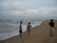
is the source of fresh water for the city-dwellers. The Nhat Le Beach
Nhat Le Beach
Nhật Lệ Beach is a beach in Đồng Hới city, the capital of Quảng Bình Province, home to world heritage Phong Nha-Ke Bang National Park. The sand here is fine and white with clean water. The beach is located on the mouth of the Nhật Lệ River emptying into the South China Sea. There is a four-star...
is endowed with fine and white sand.
Climate
Like all provinces in north and north central of Vietnam, there are four distinct seasons in Đồng Hới. In the spring, it is cool, humid and foggy. The average annual temperature is 24.40C, average rainfall varies from 1,300 – 4,000 mm, total sunshine hours per year is 1,786 hours, average annual moisture is around 84%. The city has moonson climate with three types of wind: southeast wind (gió nồm), southwest wind (gió nam), and northeast wind.Although the city is located by the sea, its climate is subject to drought in the summer, this is largely due to the dry southwest wind from Gulf of Thailand
Gulf of Thailand
The Gulf of Thailand , also known in to Malays as Teluk Siam literally meant Gulf of Siam, is a shallow arm of the South China Sea.-Geography:...
(this flow of wind is wet but when it passes to Vietnam, Annamite Range
Annamite Range
The Annamite Range or the Annamese Mountains is a mountain range of eastern Indochina, which extends approximately through Laos, Vietnam, and a small area in northeast Cambodia. It is known in Vietnamese as Dãy Trường Sơn, in Lao as Xai Phou Luang , and in French as the Chaîne Annamitique...
mountain range keeps its humidity to cause rains in Laos but drought in central Vietnam). It is rainy in the fall but the weather is comfortable with the temperature around 26 to 31 degrees Celsius. In the winter, due to the northeast wind blowing from the Chinese
China
Chinese civilization may refer to:* China for more general discussion of the country.* Chinese culture* Greater China, the transnational community of ethnic Chinese.* History of China* Sinosphere, the area historically affected by Chinese culture...
mainland, the temperature may go down below 18 degrees Celsius, and there may be slight rain. The highest precipitation gets highest level in August (118.4 mm), compared to just 38.9 mm in January.
| Average temperature | Jan | Feb | Mar | Apr | May | Jun | Jul | Aug | Sep | Oct | Nov | Dec | |
|---|---|---|---|---|---|---|---|---|---|---|---|---|---|
| Highest (°C) | 22 | 23 | 25 | 29 | 32 | 34 | 34 | 33 | 31 | 28 | 26 | 23 | |
| Lowest (°C) | 17 | 18 | 20 | 23 | 25 | 27 | 27 | 26 | 25 | 23 | 21 | 18 | |
| Sources: msn weather | |||||||||||||
Topography and geology
The city has diverse topographical and geological features, including hill, mountainous, half mountainous, coastal plains and coastal sand dunes.Hilly region is located in the west part of the city, stretching from north to south (in parts of communes: Dong Son, Thuan Duc) with an average elevation of 12–15 m, with total area of 64.93 km², 41.7% of the city total area. Residents here live on agriculture, forestry, farming. The soil in this are is poor in nutrition, unfertile and subject to continuous erosions due to its slope of 7 - 10%.
Half hilly region surrounds a plain with an average elevation of 10 m from northeast - north to northwest – southwest and south – southeast. This region covers commues and wards of Bắc Lý, Nam Lý, Nghĩa Ninh, Bắc Nghĩa, Đức Ninh, Đức Ninh Đông, Lộc Ninh and Phú Hải with total area of 62.87 km², or accounts for 40.2% of the city total area. Residents here lives on industrial, handcraft, trading and a small percentage lives on farming.
This region is not very fertile, subject to alum. However, thanks to the heavy distribution of rivers and lakes, ponds and pools, it's better for agriculture than those in hilly region.
The plain with the average of 2.1 m, with little slope, accounting for 0.2% of the city total area (5.76 km²). Most of the city's commercial, administrative and main streets concentrate in this narrow regions.
Coastal sand dune area is located on the east of the city, with an area of 21.98 km², making up 14,3% of the total area. This region features several sand dunes. Many small fresh water ponds are sandwiched into sand dunes, namely Bàu Tró
Bau Tro
Bau Tro is a lake in Dong Hoi city, Quang Binh Province, Vietnam. This lake is an important fresh water supply for more than 130,000 inhabitants of Dong Hoi City. But Bau Tro is more known for archaeological findings by French archaeologists during French Indochina periods...
, bàu Nghị, Bàu Tràm, Bàu Thôn, and Bàu Trung Bính.
Administration
Đồng Hới is subdivided into 16 subdivisions, 10 urban wards (phường) and 6 rural communes (xã).| No. | Name | Vietnamese | Population 2009 | Area (km²) | ||
|---|---|---|---|---|---|---|
| Inner Wards: | ||||||
| 1. | Bac Ly | Phường Bắc Lý | 14,158 | 10.19 | ||
| 2. | Bac Nghia | Phường Bắc Nghĩa | 6,981 | 7.76 | ||
| 3. | Dong My | Phường Đồng Mỹ | 2,757 | 0.58 | ||
| 4. | Dong Phu | Phường Đồng Phú | 8,646 | 3.81 | ||
| 5. | Dong Son | Phường Đồng Sơn | 9,127 | 19.65 | ||
| 6. | Duc Ninh Dong | Phường Đức Ninh Đông | 5,031 | 3.13 | ||
| 7. | Hai Dinh | Phường Hải Đình | 3,878 | 8.822 | ||
| 8. | Hai Thanh | Phường Hải Thành | 4,774 | 2.45 | ||
| 9. | Nam Ly | Phường Nam Lý | 11,912 | 3.9 | ||
| 10. | Phu Hai | Phường Phú Hải | 3,581 | 3.06 | ||
| Total Inner Wards | 10 wards | 10 phường | 71,620 | 55.47 | ||
| Suburban Communes: | ||||||
| 11. | Bao Ninh | Xã Bảo Ninh | 8,906 | 16.3 | ||
| 12. | Duc Ninh | Xã Đức Ninh | 7,526 | 5.21 | ||
| 13. | Loc Ninh | Xã Lộc Ninh | 8,647 | 13.4 | ||
| 14. | Nghia Ninh | Xã Nghĩa Ninh | 4,642 | 16.22 | ||
| 15. | Quang Phu | Xã Quang Phú | 3,178 | 3.23 | ||
| 16. | Thuan Duc | Xã Thuận Đức | 3,788 | 45.28 | ||
| Total Suburban Communes | 6 communes | 6 xã | 36,906 | 100.24 | ||
| Whole City | 10 wards, 6 communes | 10 phường, 6 xã | 108,526 | 155.71 | ||
Tourism

Bang Spa
Bang Spa is an area of hot mineral springs in Le Thuy County, Quang Binh Province, Vietnam. The surface mineral water here is hot enough to boil eggs. This is a tourist attraction of the province as many see bathing in hot mineral water as a health treatment for several diseases...
(hot mineral spring) is ideal for those who enjoy spa baths. The city is situated 50 km south of the World Heritage Phong Nha-Ke Bang
Phong Nha-Ke Bang
Phong Nha - Ke Bang is a national park and UNESCO World Heritage Site in the Bố Trạch and Minh Hóa districts of central Quang Binh Province, in north-central Vietnam, about 500 km south of the nation's capital, Hanoi. The park borders the Hin Namno Nature Reserve in the province of Khammouan,...
National Park which is ideal for cave and grotto exploration and biological research activities (mainly Phong Nha Cave
Phong Nha cave
Phong Nha Cave is a cave in Phong Nha-Ke Bang National Park, a UNESCO World Heritage Site in Quang Binh Province, Vietnam. It is 7729 meters long and contains 14 grottos, as well as a 13,969 meter underground river. While scientists have surveyed it to a depth of 44.5 kilometers, tourists are only...
, Tien Son Cave and from September 2010 Thien Duong Cave
Thien Duong Cave
Thiên Đường Cave is a cave in Phong Nha-Ke Bang National Park, UNESCO's World Heritage Site, 60 km northwest of Đồng Hới city....
, Son Doong Cave
Son Doong Cave
Son Doong cave is a cave in Phong Nha-Ke Bang National Park, Bo Trach District, Quang Binh Province, Vietnam. The cave is located near the Laos-Vietnam border . It has a large fast-flowing underground river inside.The cave was found by a local man named Hồ-Khanh in 1991...
has yet been available for visitors). Đồng Hới is also included in former battlefield tours where travelers can visit several once dangerous fields along Annamite Range
Annamite Range
The Annamite Range or the Annamese Mountains is a mountain range of eastern Indochina, which extends approximately through Laos, Vietnam, and a small area in northeast Cambodia. It is known in Vietnamese as Dãy Trường Sơn, in Lao as Xai Phou Luang , and in French as the Chaîne Annamitique...
and Ho Chi Minh Trail
Ho Chi Minh trail
The Ho Chi Minh trail was a logistical system that ran from the Democratic Republic of Vietnam to the Republic of Vietnam through the neighboring kingdoms of Laos and Cambodia...
. Đồng Hới is accessible by road (National Highway 1A, Hồ Chí Minh Highway), by rail at Dong Hoi Railway Station on the Hà Nội-Hồ Chí Minh City Railway, or by air from Hà Nội or Hồ Chí Minh City at Dong Hoi Airport
Dong Hoi Airport
Dong Hoi Airport is an airport located in Loc Ninh commune, 6 km north of Dong Hoi city, capital of Quang Binh province, in North Central Coast of Vietnam, 500 km South-east of Hanoi by road. The facilities cover 173 ha, on a sandy area, by the coast of South China Sea...
, an airport that the construction was completed and put into use on May 18, 2008. The consrtuction schedule of the airport was late due to lack of capital from the government. It was scheduled to be completed in February 2008, but there are some pending items (10% of the total work), the deadline was extended. The airport was completed and opened on May 18, 2008 with the first commercial flight from Hanoi
Hanoi
Hanoi , is the capital of Vietnam and the country's second largest city. Its population in 2009 was estimated at 2.6 million for urban districts, 6.5 million for the metropolitan jurisdiction. From 1010 until 1802, it was the most important political centre of Vietnam...
's Noi Bai International Airport
Noi Bai International Airport
Noi Bai International Airport in Hanoi, the capital of Vietnam, is the largest in the north of the country. It is 28 miles from the city centre. The travel time from the city centre is 30–45 minutes.-Facilities:...
and followed by air link with Ho Chi Minh City
Ho Chi Minh City
Ho Chi Minh City , formerly named Saigon is the largest city in Vietnam...
's Tan Son Nhat International Airport
Tan Son Nhat International Airport
Tan Son Nhat International Airport is Vietnam's largest international airport in terms of area . It has a handling capacity of 15-17 million passengers per year, compared with the capacity of Hanoi - Noi Bai airport of 8 million passengers and Da Nang's 2 million passengers...
from July 1, 2009.
The city provides tourists with 98 hotels and guest-houses from 1 to 3-star hotels like Cosevco Hotel, Saigon-Quảng Bình Hotel and especially the 4-star resort of Sun Spa Resort. The available cuisine includes seafood, the traditional "hot pot
Hot pot
Hot pot , less commonly Chinese fondue or steamboat, refers to several East Asian varieties of stew, consisting of a simmering metal pot of stock at the center of the dining table. While the hot pot is kept simmering, ingredients are placed into the pot and are cooked at the table...
", Vietnamese and European-style meals. In 2005, the city welcomed nearly 300,000 visitors.
Economy
The Hòn La bay is a 4-square-km bay, with the depth up to 15 m, suitable to develop into a deep-water sea port, a port is currently under construction north of Đồng Hới, the port when finished will be able to accommodate ships up to 50,000 metric tons, located on a 32ha of land, has a loading capacity of 10-12 million tonnes per year and is expected to facilitate business for Quang Binh's industrial and economic zones once operational. Two industrial parks (Northwest Đồng Hới Industrial Park and Hòn La Industrial Park) are also under construction and partially available now to investors. The city achieved an average economic growth rate of 12.5% during 2001-2005 period. The economic contributors for 2005 were as follows: industry and construction accounting for 35.5%, services 50.9%, agriculture-forestry-fishery 13.6%. GDP per capita in 2005 was $750.Education
Đồng Hới is home to Quang Binh UniversityQuang Binh University
Quang Binh University is a university established in 2006 on the basis of merge of some colleges with the Normal College as the core in Dong Hoi city, the capital of Quang Binh Province.The university accept entry exam candidate registers as of 2007...
, a multidisciplinary uiversity. There are several schools here, notable Đào Duy Từ
Đào Duy Từ
Đào Duy Từ was a Vietnamese scholar, military adviser, and mandarin who served under the reign of Nguyễn Lord Nguyễn Phúc Nguyên.-Early life:...
School.
See also
- Bau TroBau TroBau Tro is a lake in Dong Hoi city, Quang Binh Province, Vietnam. This lake is an important fresh water supply for more than 130,000 inhabitants of Dong Hoi City. But Bau Tro is more known for archaeological findings by French archaeologists during French Indochina periods...
- Đồng Hới on wikimapia
- Đồng Hới by images