

Desaguadero River
Encyclopedia
Argentina
Argentina , officially the Argentine Republic , is the second largest country in South America by land area, after Brazil. It is constituted as a federation of 23 provinces and an autonomous city, Buenos Aires...
that receives a number of different names on its path of 1,515 kilometres, with its most important section named Desaguadero proper.
Spring
Its source, a spring, is located in the AndesAndes
The Andes is the world's longest continental mountain range. It is a continual range of highlands along the western coast of South America. This range is about long, about to wide , and of an average height of about .Along its length, the Andes is split into several ranges, which are separated...
around coordinates 27°47′18"S 68°36′17"W, at 5,500 metres of height, on the southern slope of the Cerro Bonete mountain, in the north of La Rioja Province
La Rioja Province (Argentina)
La Rioja is a one of the provinces of Argentina and is located in the west of the country. Neighboring provinces are from the north clockwise Catamarca, Córdoba, San Luis and San Juan.-History:...
, near the limit with Catamarca Province
Catamarca Province
Catamarca is a province of Argentina, located in the northwest of the country. The province has a population of 334,568 as per the , and covers an area of 102,602 km². Its literacy rate is 95.5%. Neighbouring provinces are : Salta, Tucumán, Santiago del Estero, Córdoba, and La Rioja...
.
In La Rioja the river is named, in order, of Río de Oro, Río Bonete and Jagüé, though its mainly known as either Vinchina or Bermejo, creating sometimes confusion with the Bermejo River
Bermejo River
The Bermejo River is a river in South America that flows from Bolivia to the Paraguay River in Argentina. The river is generally called Bermejo in spite of its different names along its way, but it also has its own Native American names; in Wichí it is called Teuco, and in Guaraní it is called Ypitá...
located further north.
Cuyo
The river continues south-southeast to cross the east of San Juan ProvinceSan Juan Province (Argentina)
San Juan is a province of Argentina, located in the western part of the country. Neighbouring provinces are, moving clockwise from the north, La Rioja, San Luis and Mendoza. It borders with Chile at the west....
, were it receives the waters of tributaries
Tributary
A tributary or affluent is a stream or river that flows into a main stem river or a lake. A tributary does not flow directly into a sea or ocean...
Jáchal River
Jáchal River
The Jáchal River is a river in the province of San Juan, Argentina. It is part of the Desaguadero River basin, and one of the most important permanent watercourses in the province, with an average flow of 9 m³/s...
and San Juan River
San Juan River (Argentina)
The San Juan River is, together with the Jáchal, the most important river of the Argentine province of San Juan. Both join the Desaguadero/Colorado system that end at the Atlantic Ocean....
(the latter itself fed by the Mendoza River
Mendoza River
The Mendoza River is a river in the province of Mendoza, Argentina. It is formed in the Andes range between the Aconcagua and the Tupungato, by the confluence of the Vacas, the Cuevas and the Tupungato Rivers, the last being its major tributary....
).
As it gets closer to the provinces
Provinces of Argentina
Argentina is subdivided into twenty-three provinces and one autonomous city...
of Mendoza
Mendoza Province
The Province of Mendoza is a province of Argentina, located in the western central part of the country in the Cuyo region. It borders to the north with San Juan, the south with La Pampa and Neuquén, the east with San Luis, and to the west with the republic of Chile; the international limit is...
and San Luis
San Luis Province
San Luis is a province of Argentina located near the geographical center of the country . Neighboring provinces are, from the north clockwise, La Rioja, Córdoba, La Pampa, Mendoza and San Juan.-History:...
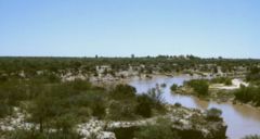
, it reaches a deeper area where it created the Lagunas de Guanacache lagoons, currently almost dried out.
Leaving the lagoon areas the river is called Desaguadero ("outlet") and becomes the natural limit between Mendoza and San Luis provinces. From Mendoza it receives the tributaries Tunuyán
Tunuyán River
The Tunuyán River is a river in the Argentine province of Mendoza. It is born in Mount Tupungato, in the Andes range, and flows initially to the northeast, passing by the city of Tunuyán. It is then dammed by the El Carrizal Dam, after which it turns east-southeast passing near the cities of...
, Diamante
Diamante River
The Diamante River is a river in the Argentine province of Mendoza. It is born from glaciers on the Maipo, a volcano in the Andes range in the Argentine–Chilean border, and flows east until emptying in the Desaguadero River...
and Guandacol before reaching the parallel 36°S to then enter La Pampa Province
La Pampa Province
La Pampa is a sparsely populated province of Argentina, located in the Pampas in the center of the country. Neighboring provinces are from the north clockwise San Luis, Córdoba, Buenos Aires, Río Negro, Neuquén and Mendoza.-History:...
. Shortly after it receives from the west the tributary Atuel River
Atuel River
The Atuel River is a river located mainly in the south of the Argentine province of Mendoza, with its last part in La Pampa. It is a tributary of the Desaguadero River....
; the overflows of both rivers in that area form the Bañados del Atuel.
La Pampa
From these wetlandWetland
A wetland is an area of land whose soil is saturated with water either permanently or seasonally. Wetlands are categorised by their characteristic vegetation, which is adapted to these unique soil conditions....
s and down to the Urre Lauquén and La Salada lagoons, it receives the name of Chadileuvú or Chadileo, words in Mapuche
Mapudungun
The Mapuche language, Mapudungun is a language isolate spoken in south-central Chile and west central Argentina by the Mapuche people. It is also spelled Mapuzugun and sometimes called Mapudungu or Araucanian...
that mean "Salty River" (Río Salado), another of the names it receives.
After Urre Lauquén it acquires yet another name - Curacó ("Stone Water"), finishing at the Colorado River
Colorado River (Argentina)
The Colorado River is a river in the south of Argentina.The Colorado river marks most of the political limit between the provinces of Neuquén and Mendoza, and between Rio Negro and La Pampa...
near coordinates 38°50′07"S 64°58′47"W.
Basin of the Desaguadero
The entire Desaguadero and its tributaries conform what is known as the Basin of the Desaguadero, located over a geologic faultGeologic fault
In geology, a fault is a planar fracture or discontinuity in a volume of rock, across which there has been significant displacement along the fractures as a result of earth movement. Large faults within the Earth's crust result from the action of tectonic forces...
that separates the west from the Sierras Pampeanas
Sierras pampeanas
The Sierras pampeanas or Pampas Sierras is a geographical region of Argentina.The Sierras pampeanas are a chain of mountains that rise sharply from the surrounding pampa region of Northwest Argentina...
.
The basin consists of around 260,000 km², covering the Cuyo
Cuyo (Argentina)
Cuyo is the name given to the wine-producing, mountainous area of central-west Argentina. Historically it comprised the provinces of San Juan, San Luis and Mendoza. The term New Cuyo is a modern one, which indicates both Cuyo proper and the province of La Rioja...
region almost completely, and the north of La Pampa Province.
Its tributaries being mainly ice-thaw-fed rivers from the Andes
Andes
The Andes is the world's longest continental mountain range. It is a continual range of highlands along the western coast of South America. This range is about long, about to wide , and of an average height of about .Along its length, the Andes is split into several ranges, which are separated...
, the current of the Desaguadero is strongest in early summer.
The section that separates Mendoza from San Luis is contained by 6- to 8-metre high ravine
Ravine
A ravine is a landform narrower than a canyon and is often the product of streamcutting erosion. Ravines are typically classified as larger in scale than gullies, although smaller than valleys. A ravine is generally a fluvial slope landform of relatively steep sides, on the order of twenty to...
s with a maximum width of over 50 metres, but due to the deviation of its waters for irrigation channels in the provinces of San Juan, Mendoza and San Luis, the section called Curacó currently has an extremely low level, providing practically no water to the Colorado.