

Atuel River
Encyclopedia
Argentina
Argentina , officially the Argentine Republic , is the second largest country in South America by land area, after Brazil. It is constituted as a federation of 23 provinces and an autonomous city, Buenos Aires...
province
Provinces of Argentina
Argentina is subdivided into twenty-three provinces and one autonomous city...
of Mendoza
Mendoza Province
The Province of Mendoza is a province of Argentina, located in the western central part of the country in the Cuyo region. It borders to the north with San Juan, the south with La Pampa and Neuquén, the east with San Luis, and to the west with the republic of Chile; the international limit is...
, with its last part in La Pampa
La Pampa Province
La Pampa is a sparsely populated province of Argentina, located in the Pampas in the center of the country. Neighboring provinces are from the north clockwise San Luis, Córdoba, Buenos Aires, Río Negro, Neuquén and Mendoza.-History:...
. It is a tributary of the Desaguadero River
Desaguadero River
The Desaguadero River is the general name of a river in western Argentina that receives a number of different names on its path of 1,515 kilometres, with its most important section named Desaguadero proper.-Spring:...
.
The Atuel is the longest river in Mendoza. It is born in the Andes
Andes
The Andes is the world's longest continental mountain range. It is a continual range of highlands along the western coast of South America. This range is about long, about to wide , and of an average height of about .Along its length, the Andes is split into several ranges, which are separated...
range, at 3,250 m above mean sea level
Above mean sea level
The term above mean sea level refers to the elevation or altitude of any object, relative to the average sea level datum. AMSL is used extensively in radio by engineers to determine the coverage area a station will be able to reach...
, from the glacial
Glacier
A glacier is a large persistent body of ice that forms where the accumulation of snow exceeds its ablation over many years, often centuries. At least 0.1 km² in area and 50 m thick, but often much larger, a glacier slowly deforms and flows due to stresses induced by its weight...
Atuel Lake. It has a mean flow of 31.8 m³/s, and its drainage basin
Drainage basin
A drainage basin is an extent or an area of land where surface water from rain and melting snow or ice converges to a single point, usually the exit of the basin, where the waters join another waterbody, such as a river, lake, reservoir, estuary, wetland, sea, or ocean...
covers 13,000 km². Its volume increases from November to March (around the summer).
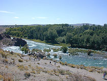
The Atuel Canyon
As it approaches the city of San Rafael, MendozaSan Rafael, Mendoza
San Rafael is a city in the southern region of the Mendoza Province, Argentina. With more than 170,000 inhabitants , it is the largest city and the seat of San Rafael Department....
, from the southwest, the Atuel is turned into a reservoir with an area of 96 km² by the El Nihuil Dam. Immediately after El Nihuil, the river becomes entrenched
Entrenched river
An entrenched river is a river that is confined to a canyon or gorge, usually with a relatively narrow width and little or no flood plain, and often with meanders worn into the landscape...
along a canyon
Canyon
A canyon or gorge is a deep ravine between cliffs often carved from the landscape by a river. Rivers have a natural tendency to reach a baseline elevation, which is the same elevation as the body of water it will eventually drain into. This forms a canyon. Most canyons were formed by a process of...
and forms rapid
Rapid
A rapid is a section of a river where the river bed has a relatively steep gradient causing an increase in water velocity and turbulence. A rapid is a hydrological feature between a run and a cascade. A rapid is characterised by the river becoming shallower and having some rocks exposed above the...
s. The canyon is about 60 km long, and during its course the river falls from 1,250 to 700 m above sea level. This level difference is taken advantage of by four hydroelectric
Hydroelectricity
Hydroelectricity is the term referring to electricity generated by hydropower; the production of electrical power through the use of the gravitational force of falling or flowing water. It is the most widely used form of renewable energy...
power station
Power station
A power station is an industrial facility for the generation of electric energy....
s (Nihuil I, II, III and IV). Most of the Atuel's flow at this point has been redirected through a system of tunnels inside the mountains, connecting the chain of reservoirs.
The Atuel Canyon area is a major tourist attraction, featuring hotels, camping sites, country clubs and other lodging facilities. The rapids are employed for rafting
Rafting
Rafting or white water rafting is a challenging recreational outdoor activity using an inflatable raft to navigate a river or other bodies of water. This is usually done on white water or different degrees of rough water, in order to thrill and excite the raft passengers. The development of this...
and canoeing
Canoeing
Canoeing is an outdoor activity that involves a special kind of canoe.Open canoes may be 'poled' , sailed, 'lined and tracked' or even 'gunnel-bobbed'....
; they are classified between class II (novice) and IV (advanced) in the International Scale of River Difficulty
International Scale of River Difficulty
The International Scale of River Difficulty is a standardized scale used to rate the safety of a stretch of river, or a single rapid. The grade reflects the technical difficulty and skill level required associated with the section of river...
.
The canyon ends in the Rincón del Atuel. From there on the river flows along a plain, becoming wider and meander
Meander
A meander in general is a bend in a sinuous watercourse. A meander is formed when the moving water in a stream erodes the outer banks and widens its valley. A stream of any volume may assume a meandering course, alternately eroding sediments from the outside of a bend and depositing them on the...
ing until reaching the Desaguadero River.