
Cyclone Gamede
Encyclopedia
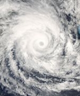
Cyclone Gamede was among the wettest tropical cyclones on record, dropping more than 5.5 m (18 ft) of rain in a nine-day period on Réunion
island in the southwest Indian Ocean
. The seventh named storm of the 2006-07 South-West Indian Ocean cyclone season
, Gamede formed on February 20 as a tropical depression to the south of Diego Garcia
. It tracked generally westward and steadily intensified, passing northwest of Mauritius
and Réunion
as a broad but moderately intense tropical cyclone. For four days it remained within 400 km (250 mi) of Réunion before accelerating southward, and on March 3 Gamede transitioned into an extratropical cyclone
to the south of Madagascar
.
Gamede broke rainfall records set by Tropical Cyclone Hyacinthe 27 years earlier for the accumulated totals between three and nine days. The rainfall caused moderate damage in Réunion, and in the southern portion of the island a bridge collapsed due to the storm. Two people each were killed on Mauritius and Réunion. The name Gamede was submitted to the World Meteorological Organization
by South Africa.
. It quickly developed banding features, and organized into a tropical disturbance. Located beneath an anticyclone
, the system experienced weak vertical wind shear
and favorable outflow
. With a subtropical ridge
to its south, the disturbance tracked quickly westward. Early on February 20, Météo-France
(MFR) classified the system as Tropical Depression Ten, and later in the day the Joint Typhoon Warning Center
(JTWC) issued a tropical cyclone formation alert
as the convection improved significantly in organization. It strengthened further, attaining tropical storm status by 0000 UTC
on February 21, and six hours later the MFR named the system Gamede while it was about 785 km (490 mi) south-southwest of Diego Garcia, or about 995 km (620 mi) northeast of Rodrigues
.
After being named, Gamede quickly intensified, and the JTWC classified it with winds of 120 km/h (75 mph) early on February 22. As it turned west-southwestward, an eye feature
became evident on satellite imagery, and the JTWC upgraded Gamede to tropical cyclone status
, or the equivalence of a minimal hurricane. Subsequently, its intensification rate slowed somewhat, due to restricted outflow. At 0000 UTC on February 23 the MFR upgraded the storm to Tropical Cyclone Gamede, and shortly thereafter it passed over Saint Brandon Island
. Subsequently, outflow became better established, and the JTWC unofficially estimated the cyclone attained winds of 185 km/h (115 mph) late on February 23 about 250 km (400 mi) north-northeast of Mauritius
island. Initially it was forecast to strengthen further, though slight weakening occurred when a nearby upper-level trough
restricted outflow.
Cyclone Gamede remained a broad system, and by February 24 it produced winds of near gale force up to 670 km (415 mi) southeast of its center; later in the day, it passed about 300 km (190 mi) north of Réunion
, its closest point of approach to the island. For over 90 hours, the cyclone remained within 400 km (250 mi) of the island, resulting in torrential rainfall in the island's mountainous region. Radar imagery on the island indicated Gamede maintained an eye diameter of 60–70 km (37–43 mi). After tracking generally southwestward for several days, a building ridge to its south changed the motion of the cyclone to the west before it became quasi-stationary. Initially, it was predicted to continue westward and strike Madagascar
near Toamasina
. The cyclone re-intensified while executing a small loop, and late on February 25 Gamede officially attained peak winds of 165 km/h (105 mph) about halfway between Réunion island and the coast of Madagascar; at the time, wind gusts in association with the storm reached 230 km/h (135 mph).
The cyclone weakened while remaining nearly stationary, losing most of its deep convection due to upwelling
; this is the process in which a stationary storm causes the water temperatures to decrease by bringing the cooler, deeper waters to the surface. It remained nearly stationary until beginning a steady south-southwestward motion late on February 26, a change due to an approaching mid-level trough to its south. On February 28, convection increased around a rebuilding eyewall as it accelerated southward, though on March 1 the cyclone again weakened as wind shear increased and as water temperatures gradually decreased. Gamede weakened to tropical storm status as its center became exposed from the deep convection, and late on March 1 it transitioned into an extratropical cyclone
. After completing the transition, the storm became nearly stationary for about two days, during which its winds decreased to below gale force. The remnants of Gamede turned westward and persisted until dissipating on March 6.
, a total of 200 people evacuated to storm shelters due to the cyclone. The island was under a Cyclone Warning Class III for 36 hours, and for a few more hours it was under a Cyclone Warning Class IV, the latter meaning wind gusts of 120 km/h (75 mph) were reported or expected. Prior to the storm affecting the area, officials in Réunion
closed schools and also issued a temporary driving ban. Due to the threat of the storm, several flights in and out of Mauritius, Réunion, and Rodrigues
were canceled. Fishermen were banned from sailing out to sea.
On midday February 23, Cyclone Gamede moved over Saint Brandon Island
, where a pressure of 960 mbar
was recorded.
The cyclone affected the country of Mauritius
on February 25. Power was knocked out to 70% of the island's population, and some light infrastructure damage was also reported. Food crops were also affected. Despite warnings to remain inside, several people ventured outside during the storm. Gamede killed two on Mauritius, including one who drowned in high waves.
The large size of the cyclone resulted in several days of very heavy, continuous rainfall in the mountainous region on Réunion
island. The island is the location for several tropical cyclone rainfall records; due to the orography
of the island, tropical moisture will travel upward to the volcanic peaks, where it cools and codifies into rainfall. The heaviest totals occurred from February 24 through February 28. Commerson's Crater, located at an elevation of 2.3 km (1.4 mi), reported 2463 mm (97 in) in 48 hours, which is just short of the worldwide record set by an unnamed tropical cyclone in April 1958. Gamede broke worldwide rainfall records between three and nine days, with its total precipitation amounting to 5512 mm (217 in) in Commerson's Crater; Tropical Cyclone Hyacinthe in 1980 remains the wettest tropical cyclone on record, having produced greater totals after ten days. Several locations on the island reported great totals. In a 24 hour period, Hell-Bourg
reported 1489 mm (58.6 in), and in a 72 hour period, Cilaos
reported 2321 mm (91.4 in).
The passage of the cyclone left about 100,000 homes without power or water on Réunion. The rainfall caused some flood damage, and the combination of precipitation and strong winds caused heavy crop damage, including to the sugar cane and banana crops. Several roads and bridges were damaged on the island. A 520 m (1700 ft) bridge over the Saint Etienne River collapsed near Saint-Louis
, with the cost estimated at €20 million (2007 EUR
, $26 million 2007 USD). The bridge, which carried about 50,000 vehicles per day, collapsed as river flow increased from the heavy rainfall; two towns were left temporarily isolated due to the incident. Two people died on the island after attempting to cross rivers during the storm. Nine people were injured on the island, including two who were seriously injured. A peak wind gust of 205 km/h (127 mph) was reported on the island. On June 13, 2007, the government of France provided a relief fund to Réunion
of €17.6 million (2007 EUR) in aid, including €9.6 million for farmers affected by the cyclone. The assistance provided €7.7 million for repairing roads and infrastructure, including rebuilding the destroyed bridge over the Saint Etienne River. In the immediate aftermath of the storm, officials deployed army resources to establish a temporary aerial bridge while a new bridge was built.
Rough waves and strong winds affected a cruise ship to the east of Madagascar; several windows were broken, though no serious injuries were reported. Along Madagascar's east coast, Gamede produced squally rain and winds. Gamede had followed shortly after Tropical Cyclones Bondo, Clovis, and Favio, being the fourth tropical cyclone to impact Madagascar in two months.
Réunion
Réunion is a French island with a population of about 800,000 located in the Indian Ocean, east of Madagascar, about south west of Mauritius, the nearest island.Administratively, Réunion is one of the overseas departments of France...
island in the southwest Indian Ocean
Indian Ocean
The Indian Ocean is the third largest of the world's oceanic divisions, covering approximately 20% of the water on the Earth's surface. It is bounded on the north by the Indian Subcontinent and Arabian Peninsula ; on the west by eastern Africa; on the east by Indochina, the Sunda Islands, and...
. The seventh named storm of the 2006-07 South-West Indian Ocean cyclone season
2006-07 South-West Indian Ocean cyclone season
The 2006–07 South-West Indian Ocean cyclone season was an annual event of tropical cyclone formation which started on November 15, 2006 and ended on April 30, 2007 for most areas and on May 15, 2007 for Mauritius and the Seychelles. These dates conventionally delimit the period of each year when...
, Gamede formed on February 20 as a tropical depression to the south of Diego Garcia
Diego Garcia
Diego Garcia is a tropical, footprint-shaped coral atoll located south of the equator in the central Indian Ocean at 7 degrees, 26 minutes south latitude. It is part of the British Indian Ocean Territory [BIOT] and is positioned at 72°23' east longitude....
. It tracked generally westward and steadily intensified, passing northwest of Mauritius
Mauritius
Mauritius , officially the Republic of Mauritius is an island nation off the southeast coast of the African continent in the southwest Indian Ocean, about east of Madagascar...
and Réunion
Réunion
Réunion is a French island with a population of about 800,000 located in the Indian Ocean, east of Madagascar, about south west of Mauritius, the nearest island.Administratively, Réunion is one of the overseas departments of France...
as a broad but moderately intense tropical cyclone. For four days it remained within 400 km (250 mi) of Réunion before accelerating southward, and on March 3 Gamede transitioned into an extratropical cyclone
Extratropical cyclone
Extratropical cyclones, sometimes called mid-latitude cyclones or wave cyclones, are a group of cyclones defined as synoptic scale low pressure weather systems that occur in the middle latitudes of the Earth having neither tropical nor polar characteristics, and are connected with fronts and...
to the south of Madagascar
Madagascar
The Republic of Madagascar is an island country located in the Indian Ocean off the southeastern coast of Africa...
.
Gamede broke rainfall records set by Tropical Cyclone Hyacinthe 27 years earlier for the accumulated totals between three and nine days. The rainfall caused moderate damage in Réunion, and in the southern portion of the island a bridge collapsed due to the storm. Two people each were killed on Mauritius and Réunion. The name Gamede was submitted to the World Meteorological Organization
World Meteorological Organization
The World Meteorological Organization is an intergovernmental organization with a membership of 189 Member States and Territories. It originated from the International Meteorological Organization , which was founded in 1873...
by South Africa.
Meteorological history
On February 19, an area of convection persisted over a weak, but well-defined low-level circulation about 1130 km (700 mi) southeast of Diego GarciaDiego Garcia
Diego Garcia is a tropical, footprint-shaped coral atoll located south of the equator in the central Indian Ocean at 7 degrees, 26 minutes south latitude. It is part of the British Indian Ocean Territory [BIOT] and is positioned at 72°23' east longitude....
. It quickly developed banding features, and organized into a tropical disturbance. Located beneath an anticyclone
Anticyclone
An anticyclone is a weather phenomenon defined by the United States' National Weather Service's glossary as "[a] large-scale circulation of winds around a central region of high atmospheric pressure, clockwise in the Northern Hemisphere, counterclockwise in the Southern Hemisphere"...
, the system experienced weak vertical wind shear
Wind shear
Wind shear, sometimes referred to as windshear or wind gradient, is a difference in wind speed and direction over a relatively short distance in the atmosphere...
and favorable outflow
Outflow (meteorology)
Outflow, in meteorology, is air that flows outwards from a storm system. It is associated with ridging, or anticyclonic flow. In the low levels of the troposphere, outflow radiates from thunderstorms in the form of a wedge of rain-cooled air, which is visible as a thin rope-like cloud on weather...
. With a subtropical ridge
Subtropical ridge
The subtropical ridge is a significant belt of high pressure situated around the latitudes of 30°N in the Northern Hemisphere and 30°S in the Southern Hemisphere. It is characterized by mostly calm winds, which acts to reduce air quality under its axis by causing fog overnight, and haze during...
to its south, the disturbance tracked quickly westward. Early on February 20, Météo-France
Météo-France
Météo-France is the French national meteorological service.The organisation was established by decree in June 1993 and is a department of the Ministry of Transportation. It is headquartered in Paris but many domestic operations have been decentralised to Toulouse...
(MFR) classified the system as Tropical Depression Ten, and later in the day the Joint Typhoon Warning Center
Joint Typhoon Warning Center
The Joint Typhoon Warning Center is a joint United States Navy – United States Air Force task force located at the Naval Maritime Forecast Center in Pearl Harbor, Hawaii...
(JTWC) issued a tropical cyclone formation alert
Tropical Cyclone Formation Alert
A Tropical Cyclone Formation Alert is a bulletin released by the U.S. Navy-operated Joint Typhoon Warning Center in Honolulu, Hawaii or the Naval Maritime Forecast Center in Norfolk, Virginia, warning of the possibility of a tropical cyclone forming from a tropical disturbance that has been...
as the convection improved significantly in organization. It strengthened further, attaining tropical storm status by 0000 UTC
Coordinated Universal Time
Coordinated Universal Time is the primary time standard by which the world regulates clocks and time. It is one of several closely related successors to Greenwich Mean Time. Computer servers, online services and other entities that rely on having a universally accepted time use UTC for that purpose...
on February 21, and six hours later the MFR named the system Gamede while it was about 785 km (490 mi) south-southwest of Diego Garcia, or about 995 km (620 mi) northeast of Rodrigues
Rodrigues (island)
Rodrigues , sometimes spelled Rodriguez but named after the Portuguese explorer Diogo Rodrigues, is the smallest of the Mascarene Islands and a dependency of Mauritius...
.
After being named, Gamede quickly intensified, and the JTWC classified it with winds of 120 km/h (75 mph) early on February 22. As it turned west-southwestward, an eye feature
Eye (cyclone)
The eye is a region of mostly calm weather found at the center of strong tropical cyclones. The eye of a storm is a roughly circular area and typically 30–65 km in diameter. It is surrounded by the eyewall, a ring of towering thunderstorms where the second most severe weather of a cyclone...
became evident on satellite imagery, and the JTWC upgraded Gamede to tropical cyclone status
Tropical cyclone scales
Tropical systems are officially ranked on one of several tropical cyclone scales according to their maximum sustained winds and in what oceanic basin they are located...
, or the equivalence of a minimal hurricane. Subsequently, its intensification rate slowed somewhat, due to restricted outflow. At 0000 UTC on February 23 the MFR upgraded the storm to Tropical Cyclone Gamede, and shortly thereafter it passed over Saint Brandon Island
Cargados Carajos
Cargados Carajos Shoals are a group of about 16 small islands and islets on an extended reef in the Indian Ocean northeast of Mauritius. The islands have a total land area of 1.3 km². The reef measures more than 50 km from north to south, and is 5 km wide, cut by three passes. The...
. Subsequently, outflow became better established, and the JTWC unofficially estimated the cyclone attained winds of 185 km/h (115 mph) late on February 23 about 250 km (400 mi) north-northeast of Mauritius
Mauritius
Mauritius , officially the Republic of Mauritius is an island nation off the southeast coast of the African continent in the southwest Indian Ocean, about east of Madagascar...
island. Initially it was forecast to strengthen further, though slight weakening occurred when a nearby upper-level trough
Trough (meteorology)
A trough is an elongated region of relatively low atmospheric pressure, often associated with fronts.Unlike fronts, there is not a universal symbol for a trough on a weather chart. The weather charts in some countries or regions mark troughs by a line. In the United States, a trough may be marked...
restricted outflow.
Cyclone Gamede remained a broad system, and by February 24 it produced winds of near gale force up to 670 km (415 mi) southeast of its center; later in the day, it passed about 300 km (190 mi) north of Réunion
Réunion
Réunion is a French island with a population of about 800,000 located in the Indian Ocean, east of Madagascar, about south west of Mauritius, the nearest island.Administratively, Réunion is one of the overseas departments of France...
, its closest point of approach to the island. For over 90 hours, the cyclone remained within 400 km (250 mi) of the island, resulting in torrential rainfall in the island's mountainous region. Radar imagery on the island indicated Gamede maintained an eye diameter of 60–70 km (37–43 mi). After tracking generally southwestward for several days, a building ridge to its south changed the motion of the cyclone to the west before it became quasi-stationary. Initially, it was predicted to continue westward and strike Madagascar
Madagascar
The Republic of Madagascar is an island country located in the Indian Ocean off the southeastern coast of Africa...
near Toamasina
Toamasina
Toamasina , meaning "like salt" or "salty", unofficially and in French also Tamatave, is a city on the east coast of Madagascar on the Indian Ocean. The city is the chief seaport of the country, situated northeast of its capital and biggest city Antananarivo, near the centre of the eastern coast...
. The cyclone re-intensified while executing a small loop, and late on February 25 Gamede officially attained peak winds of 165 km/h (105 mph) about halfway between Réunion island and the coast of Madagascar; at the time, wind gusts in association with the storm reached 230 km/h (135 mph).
The cyclone weakened while remaining nearly stationary, losing most of its deep convection due to upwelling
Upwelling
Upwelling is an oceanographic phenomenon that involves wind-driven motion of dense, cooler, and usually nutrient-rich water towards the ocean surface, replacing the warmer, usually nutrient-depleted surface water. The increased availability in upwelling regions results in high levels of primary...
; this is the process in which a stationary storm causes the water temperatures to decrease by bringing the cooler, deeper waters to the surface. It remained nearly stationary until beginning a steady south-southwestward motion late on February 26, a change due to an approaching mid-level trough to its south. On February 28, convection increased around a rebuilding eyewall as it accelerated southward, though on March 1 the cyclone again weakened as wind shear increased and as water temperatures gradually decreased. Gamede weakened to tropical storm status as its center became exposed from the deep convection, and late on March 1 it transitioned into an extratropical cyclone
Extratropical cyclone
Extratropical cyclones, sometimes called mid-latitude cyclones or wave cyclones, are a group of cyclones defined as synoptic scale low pressure weather systems that occur in the middle latitudes of the Earth having neither tropical nor polar characteristics, and are connected with fronts and...
. After completing the transition, the storm became nearly stationary for about two days, during which its winds decreased to below gale force. The remnants of Gamede turned westward and persisted until dissipating on March 6.
Preparations
In MauritiusMauritius
Mauritius , officially the Republic of Mauritius is an island nation off the southeast coast of the African continent in the southwest Indian Ocean, about east of Madagascar...
, a total of 200 people evacuated to storm shelters due to the cyclone. The island was under a Cyclone Warning Class III for 36 hours, and for a few more hours it was under a Cyclone Warning Class IV, the latter meaning wind gusts of 120 km/h (75 mph) were reported or expected. Prior to the storm affecting the area, officials in Réunion
Réunion
Réunion is a French island with a population of about 800,000 located in the Indian Ocean, east of Madagascar, about south west of Mauritius, the nearest island.Administratively, Réunion is one of the overseas departments of France...
closed schools and also issued a temporary driving ban. Due to the threat of the storm, several flights in and out of Mauritius, Réunion, and Rodrigues
Rodrigues (island)
Rodrigues , sometimes spelled Rodriguez but named after the Portuguese explorer Diogo Rodrigues, is the smallest of the Mascarene Islands and a dependency of Mauritius...
were canceled. Fishermen were banned from sailing out to sea.
Impact and records
| Duration (hours) |
Storm name and year |
Record prior to Gamede |
Gamede total | +/- (in mm) |
||
|---|---|---|---|---|---|---|
| mm | in | mm | in | |||
| 24 | Denise (1966) | 1825 | 71.8 | 1625 | 64.0 | -200 |
| 48 | Unnamed (1958) | 2467 | 97.1 | 2463 | 97.0 | -4 |
| 72 | Hyacinthe (1980) | 3240 | 127.6 | 3929 | 154.6 | +689 |
| 96 | Hyacinthe (1980) | 3551 | 139.8 | 4869 | 191.7 | +1318 |
| Total | Hyacinthe (1980) | 5678 | 223.5 | 5512 | 217.0 | -166 |
On midday February 23, Cyclone Gamede moved over Saint Brandon Island
Cargados Carajos
Cargados Carajos Shoals are a group of about 16 small islands and islets on an extended reef in the Indian Ocean northeast of Mauritius. The islands have a total land area of 1.3 km². The reef measures more than 50 km from north to south, and is 5 km wide, cut by three passes. The...
, where a pressure of 960 mbar
Bar (unit)
The bar is a unit of pressure equal to 100 kilopascals, and roughly equal to the atmospheric pressure on Earth at sea level. Other units derived from the bar are the megabar , kilobar , decibar , centibar , and millibar...
was recorded.
The cyclone affected the country of Mauritius
Mauritius
Mauritius , officially the Republic of Mauritius is an island nation off the southeast coast of the African continent in the southwest Indian Ocean, about east of Madagascar...
on February 25. Power was knocked out to 70% of the island's population, and some light infrastructure damage was also reported. Food crops were also affected. Despite warnings to remain inside, several people ventured outside during the storm. Gamede killed two on Mauritius, including one who drowned in high waves.
The large size of the cyclone resulted in several days of very heavy, continuous rainfall in the mountainous region on Réunion
Réunion
Réunion is a French island with a population of about 800,000 located in the Indian Ocean, east of Madagascar, about south west of Mauritius, the nearest island.Administratively, Réunion is one of the overseas departments of France...
island. The island is the location for several tropical cyclone rainfall records; due to the orography
Orography
Orography is the study of the formation and relief of mountains, and can more broadly include hills, and any part of a region's elevated terrain...
of the island, tropical moisture will travel upward to the volcanic peaks, where it cools and codifies into rainfall. The heaviest totals occurred from February 24 through February 28. Commerson's Crater, located at an elevation of 2.3 km (1.4 mi), reported 2463 mm (97 in) in 48 hours, which is just short of the worldwide record set by an unnamed tropical cyclone in April 1958. Gamede broke worldwide rainfall records between three and nine days, with its total precipitation amounting to 5512 mm (217 in) in Commerson's Crater; Tropical Cyclone Hyacinthe in 1980 remains the wettest tropical cyclone on record, having produced greater totals after ten days. Several locations on the island reported great totals. In a 24 hour period, Hell-Bourg
Hell-Bourg
Hell-Bourg is a small village in the Salazie commune of the French overseas department of Réunion. It is the main community in the island's Cirque de Salazie, and is named for the respected former admiral and island governor Anne Chrétien Louis de Hell. Previously the village had been named Bémaho...
reported 1489 mm (58.6 in), and in a 72 hour period, Cilaos
Cilaos
Cilaos is a town and commune on the French island of Réunion in the Indian Ocean. It is located centrally on the island, in a caldera of altitude 1214 m...
reported 2321 mm (91.4 in).
The passage of the cyclone left about 100,000 homes without power or water on Réunion. The rainfall caused some flood damage, and the combination of precipitation and strong winds caused heavy crop damage, including to the sugar cane and banana crops. Several roads and bridges were damaged on the island. A 520 m (1700 ft) bridge over the Saint Etienne River collapsed near Saint-Louis
Saint-Louis, Réunion
Saint-Louis is the fifth-largest commune in the French overseas department of Réunion. It is located on the southwest part of the island of Réunion, adjacent to Saint-Pierre.-External links:*...
, with the cost estimated at €20 million (2007 EUR
Euro
The euro is the official currency of the eurozone: 17 of the 27 member states of the European Union. It is also the currency used by the Institutions of the European Union. The eurozone consists of Austria, Belgium, Cyprus, Estonia, Finland, France, Germany, Greece, Ireland, Italy, Luxembourg,...
, $26 million 2007 USD). The bridge, which carried about 50,000 vehicles per day, collapsed as river flow increased from the heavy rainfall; two towns were left temporarily isolated due to the incident. Two people died on the island after attempting to cross rivers during the storm. Nine people were injured on the island, including two who were seriously injured. A peak wind gust of 205 km/h (127 mph) was reported on the island. On June 13, 2007, the government of France provided a relief fund to Réunion
Réunion
Réunion is a French island with a population of about 800,000 located in the Indian Ocean, east of Madagascar, about south west of Mauritius, the nearest island.Administratively, Réunion is one of the overseas departments of France...
of €17.6 million (2007 EUR) in aid, including €9.6 million for farmers affected by the cyclone. The assistance provided €7.7 million for repairing roads and infrastructure, including rebuilding the destroyed bridge over the Saint Etienne River. In the immediate aftermath of the storm, officials deployed army resources to establish a temporary aerial bridge while a new bridge was built.
Rough waves and strong winds affected a cruise ship to the east of Madagascar; several windows were broken, though no serious injuries were reported. Along Madagascar's east coast, Gamede produced squally rain and winds. Gamede had followed shortly after Tropical Cyclones Bondo, Clovis, and Favio, being the fourth tropical cyclone to impact Madagascar in two months.
See also
- List of tropical cyclones
- List of wettest tropical cyclones by country
- Geography of MadagascarGeography of MadagascarMadagascar is an island in the Indian Ocean off the eastern coast of southern Africa, east of Mozambique. It is the fourth largest island in the world. The highest point is Maromokotro, in the Tsaratanana Massif region in the north of the island, at . The capital Antananarivo is in the Hauts...