
Cyclone Agni
Encyclopedia
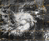
Severe Cyclonic Storm Agni (IMD Designation: ARB 0404, JTWC Designation: 05A) was a tropical cyclone
of the 2004 North Indian Ocean cyclone season
notable for its record proximity to the equator
. It was the second North Indian Ocean cyclone to receive a name, after Onil earlier in the year. Agni formed on November 28 well to the southwest of India in the Arabian Sea
, and steadily intensified as it tracked northwestward. The Joint Typhoon Warning Center
(JTWC) estimated peak 1 minute sustained winds
of 120 km/h (75 mph), while the India Meteorological Department
(IMD) estimated peak 3 minute sustained winds of 100 km/h (65 mph); the IMD is the official warning center
for the north Indian Ocean
. After peaking, it weakened due to wind shear
, dry air, and cooler waters, and the JTWC issued its final advisory on December 3 as it approached the coast of Somalia
. The remnants of Agni moved along the Somalian coastline until dissipating on December 5.
, Sri Lanka
in the Bay of Bengal
. The disturbance tracked westward, gradually organizing and prompting the JTWC to issue a Tropical Cyclone Formation Alert
(TCFA) on November 22. After passing south of Sri Lanka, it became disorganized and was no longer considered likely to develop
into a tropical cyclone. The circulation
associated with the system continued westward, reorganizing on November 26 in the Arabian Sea
. Despite being located unusually close to the equator
, the disturbance maintained convection, or thunderstorms, which was becoming organized around the weak low-level circulation. With low wind shear
and diffluence
aloft, the JTWC remarked the system had a fair chance of developing.
While the system was organizing, the center crossed the equator to reach about 0.5° S
, thus becoming an anticyclonic
circulation in the southern hemisphere. This was unusual, as the Coriolis effect
is nonresistant along the equator—the Coriolis effect refers to planetary vorticity, which provides the spin in a cyclone. The JTWC later assessed the system as remaining in the northern hemisphere, reaching as far south as 0.7° N, or about 80 km (50 mi) from the equator. After the circulation organized further beneath the convection, the JTWC issued another TCFA at 0300 UTC
on November 28. Three hours later, the agency classified the system as Tropical Cyclone 05A about 1300 km (800 mi) southwest of the southern tip of India. In a post-season analysis, the JTWC estimated the cyclone became a tropical storm six hours earlier. At around the same time, the IMD classified it as a "low pressure area... likely to become well marked."
Upon being classified, the tropical cyclone was moving northwestward under the influence of a ridge
over India. Its outflow
to the north and south became better defined, although its proximity to the equator limited its southerly outflow somewhat due to wind shear
. Early on November 29, the IMD classified the system as a depression, and throughout the day it rapidly intensified to become a cyclonic storm; a cyclonic storm is a tropical cyclone with at least 65 km/h (40 mph) winds
sustained for 3 minutes. Around that time, the JTWC assessed the cyclone as reaching peak winds of 120 km/h (75 mph), sustained for 1 minute, along with gusts to 150 km/h (90 mph). Late on November 29, the cyclone weakened slightly, only to regain its peak intensity by November 30; at that time, it developed a banding eye
, and was located about 1500 km (900 mi) southeast of the coast of Somalia
. At 1200 UTC on November 30, the IMD issued its first complete advisory on the cyclone, naming it Severe Cyclonic Storm Agni and estimating peak winds at 100 km/h (65 mph); the agency predicted the storm would continue northwestward and strengthen slightly before weakening. At its peak, the cyclone had a barometric pressure
of 985 mbar
.
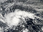
After reaching peak intensity, an increase in wind shear caused the eye to disappear, and the convection decreased significantly. On December 1, the IMD estimated Agni weakened to cyclonic storm status, around which time the center became exposed from the convection. The cyclone continued its steady weakening continued due to the wind shear, the presence of dry air, and cooler water temperatures
, and by December 2, the IMD downgraded Agni to depression status, which was its final warning on the system. As it approached the coast of Somalia, it turned westward due to the building of a ridge over Saudi Arabia
. Despite unfavorable conditions, thunderstorms briefly reformed over the circulation, which allowed the storm to maintain its intensity. By late on December 3, Agni weakened to below tropical storm status, and the JTWC issued its final warning while the storm was about 450 km (275 mi) south-southeast of Cape Guardafui
—the easternmost point of the Horn of Africa
. The circulation became difficult to locate by early on December 4, by which time the system had little remaining convection. It turned southwestward and later to the south, moving ashore on eastern Somalia before dissipating on December 5 near Ceel Huur
over water.
 Although the IMD did not begin issuing advisories until the cyclone was at 6.0° N, the JTWC assessed the storm as reaching as far south as 0.7° N, or about 80 km (50 mi) from the equator. This is the closest to the equator any tropical cyclone was ever recorded, surpassing that of Tropical Storm Vamei
which did so at 1.5° N, or about twice as far. However, the record is unofficial due to the lack of a best track by the IMD.
Agni was the second storm in the north Indian Ocean to receive a name, after the IMD began tropical cyclone naming
in the middle of 2004. The name Agni was contributed by India.
As the cyclone was weak when it moved over Somalia, no casualties or significant damage was reported.
Tropical cyclone
A tropical cyclone is a storm system characterized by a large low-pressure center and numerous thunderstorms that produce strong winds and heavy rain. Tropical cyclones strengthen when water evaporated from the ocean is released as the saturated air rises, resulting in condensation of water vapor...
of the 2004 North Indian Ocean cyclone season
2004 North Indian Ocean cyclone season
The 2004 North Indian Ocean cyclone season had no bounds, but cyclones tend to form between April and December, with peaks in May and November. These dates conventionally delimit the period of each year when most tropical cyclones form in the northern Indian Ocean.-Season summary:In 2004, RSMC New...
notable for its record proximity to the equator
Equator
An equator is the intersection of a sphere's surface with the plane perpendicular to the sphere's axis of rotation and containing the sphere's center of mass....
. It was the second North Indian Ocean cyclone to receive a name, after Onil earlier in the year. Agni formed on November 28 well to the southwest of India in the Arabian Sea
Arabian Sea
The Arabian Sea is a region of the Indian Ocean bounded on the east by India, on the north by Pakistan and Iran, on the west by the Arabian Peninsula, on the south, approximately, by a line between Cape Guardafui in northeastern Somalia and Kanyakumari in India...
, and steadily intensified as it tracked northwestward. The Joint Typhoon Warning Center
Joint Typhoon Warning Center
The Joint Typhoon Warning Center is a joint United States Navy – United States Air Force task force located at the Naval Maritime Forecast Center in Pearl Harbor, Hawaii...
(JTWC) estimated peak 1 minute sustained winds
Maximum sustained wind
The maximum sustained winds associated with a tropical cyclone are a common indicator of the intensity of the storm. Within a mature tropical cyclone, they are found within the eyewall at a distance defined as the radius of maximum wind, or RMW. Unlike gusts, the value of these winds are...
of 120 km/h (75 mph), while the India Meteorological Department
India Meteorological Department
The India Meteorological Department , also referred to as the Met Office, is an agency of the Ministry of Earth Sciences of the Government of India. It is the principal agency responsible for meteorological observations, weather forecasting and seismology...
(IMD) estimated peak 3 minute sustained winds of 100 km/h (65 mph); the IMD is the official warning center
Regional Specialized Meteorological Centre
A Regional Specialized Meteorological Centre is responsible for the distribution of information, advisories, and warnings regarding the specific program they have a part of, agreed by consensus at the World Meteorological Organization as part of the World Weather Watch.-Tropical...
for the north Indian Ocean
Indian Ocean
The Indian Ocean is the third largest of the world's oceanic divisions, covering approximately 20% of the water on the Earth's surface. It is bounded on the north by the Indian Subcontinent and Arabian Peninsula ; on the west by eastern Africa; on the east by Indochina, the Sunda Islands, and...
. After peaking, it weakened due to wind shear
Wind shear
Wind shear, sometimes referred to as windshear or wind gradient, is a difference in wind speed and direction over a relatively short distance in the atmosphere...
, dry air, and cooler waters, and the JTWC issued its final advisory on December 3 as it approached the coast of Somalia
Somalia
Somalia , officially the Somali Republic and formerly known as the Somali Democratic Republic under Socialist rule, is a country located in the Horn of Africa. Since the outbreak of the Somali Civil War in 1991 there has been no central government control over most of the country's territory...
. The remnants of Agni moved along the Somalian coastline until dissipating on December 5.
Meteorological history
A tropical disturbance was observed on November 19 about 800 km (500 mi) southeast of ColomboColombo
Colombo is the largest city of Sri Lanka. It is located on the west coast of the island and adjacent to Sri Jayawardenapura Kotte, the capital of Sri Lanka. Colombo is often referred to as the capital of the country, since Sri Jayawardenapura Kotte is a satellite city of Colombo...
, Sri Lanka
Sri Lanka
Sri Lanka, officially the Democratic Socialist Republic of Sri Lanka is a country off the southern coast of the Indian subcontinent. Known until 1972 as Ceylon , Sri Lanka is an island surrounded by the Indian Ocean, the Gulf of Mannar and the Palk Strait, and lies in the vicinity of India and the...
in the Bay of Bengal
Bay of Bengal
The Bay of Bengal , the largest bay in the world, forms the northeastern part of the Indian Ocean. It resembles a triangle in shape, and is bordered mostly by the Eastern Coast of India, southern coast of Bangladesh and Sri Lanka to the west and Burma and the Andaman and Nicobar Islands to the...
. The disturbance tracked westward, gradually organizing and prompting the JTWC to issue a Tropical Cyclone Formation Alert
Tropical Cyclone Formation Alert
A Tropical Cyclone Formation Alert is a bulletin released by the U.S. Navy-operated Joint Typhoon Warning Center in Honolulu, Hawaii or the Naval Maritime Forecast Center in Norfolk, Virginia, warning of the possibility of a tropical cyclone forming from a tropical disturbance that has been...
(TCFA) on November 22. After passing south of Sri Lanka, it became disorganized and was no longer considered likely to develop
Tropical cyclogenesis
Tropical cyclogenesis is the term that describes the development and strengthening of a tropical cyclone in the atmosphere. The mechanisms through which tropical cyclogenesis occurs are distinctly different from those through which mid-latitude cyclogenesis occurs...
into a tropical cyclone. The circulation
Atmospheric circulation
Atmospheric circulation is the large-scale movement of air, and the means by which thermal energy is distributed on the surface of the Earth....
associated with the system continued westward, reorganizing on November 26 in the Arabian Sea
Arabian Sea
The Arabian Sea is a region of the Indian Ocean bounded on the east by India, on the north by Pakistan and Iran, on the west by the Arabian Peninsula, on the south, approximately, by a line between Cape Guardafui in northeastern Somalia and Kanyakumari in India...
. Despite being located unusually close to the equator
Equator
An equator is the intersection of a sphere's surface with the plane perpendicular to the sphere's axis of rotation and containing the sphere's center of mass....
, the disturbance maintained convection, or thunderstorms, which was becoming organized around the weak low-level circulation. With low wind shear
Wind shear
Wind shear, sometimes referred to as windshear or wind gradient, is a difference in wind speed and direction over a relatively short distance in the atmosphere...
and diffluence
Deformation (meteorology)
Deformation is the rate of change of shape of fluid bodies. Meteorologically, this quantity is very important in the formation of atmospheric fronts, in the explanation of cloud shapes, and in the diffusion of materials and properties.-Equations:...
aloft, the JTWC remarked the system had a fair chance of developing.
While the system was organizing, the center crossed the equator to reach about 0.5° S
Latitude
In geography, the latitude of a location on the Earth is the angular distance of that location south or north of the Equator. The latitude is an angle, and is usually measured in degrees . The equator has a latitude of 0°, the North pole has a latitude of 90° north , and the South pole has a...
, thus becoming an anticyclonic
Anticyclone
An anticyclone is a weather phenomenon defined by the United States' National Weather Service's glossary as "[a] large-scale circulation of winds around a central region of high atmospheric pressure, clockwise in the Northern Hemisphere, counterclockwise in the Southern Hemisphere"...
circulation in the southern hemisphere. This was unusual, as the Coriolis effect
Coriolis effect
In physics, the Coriolis effect is a deflection of moving objects when they are viewed in a rotating reference frame. In a reference frame with clockwise rotation, the deflection is to the left of the motion of the object; in one with counter-clockwise rotation, the deflection is to the right...
is nonresistant along the equator—the Coriolis effect refers to planetary vorticity, which provides the spin in a cyclone. The JTWC later assessed the system as remaining in the northern hemisphere, reaching as far south as 0.7° N, or about 80 km (50 mi) from the equator. After the circulation organized further beneath the convection, the JTWC issued another TCFA at 0300 UTC
Coordinated Universal Time
Coordinated Universal Time is the primary time standard by which the world regulates clocks and time. It is one of several closely related successors to Greenwich Mean Time. Computer servers, online services and other entities that rely on having a universally accepted time use UTC for that purpose...
on November 28. Three hours later, the agency classified the system as Tropical Cyclone 05A about 1300 km (800 mi) southwest of the southern tip of India. In a post-season analysis, the JTWC estimated the cyclone became a tropical storm six hours earlier. At around the same time, the IMD classified it as a "low pressure area... likely to become well marked."
Upon being classified, the tropical cyclone was moving northwestward under the influence of a ridge
Ridge (meteorology)
A ridge is an elongated region of relatively high atmospheric pressure, the opposite of a trough....
over India. Its outflow
Outflow (meteorology)
Outflow, in meteorology, is air that flows outwards from a storm system. It is associated with ridging, or anticyclonic flow. In the low levels of the troposphere, outflow radiates from thunderstorms in the form of a wedge of rain-cooled air, which is visible as a thin rope-like cloud on weather...
to the north and south became better defined, although its proximity to the equator limited its southerly outflow somewhat due to wind shear
Wind shear
Wind shear, sometimes referred to as windshear or wind gradient, is a difference in wind speed and direction over a relatively short distance in the atmosphere...
. Early on November 29, the IMD classified the system as a depression, and throughout the day it rapidly intensified to become a cyclonic storm; a cyclonic storm is a tropical cyclone with at least 65 km/h (40 mph) winds
Maximum sustained wind
The maximum sustained winds associated with a tropical cyclone are a common indicator of the intensity of the storm. Within a mature tropical cyclone, they are found within the eyewall at a distance defined as the radius of maximum wind, or RMW. Unlike gusts, the value of these winds are...
sustained for 3 minutes. Around that time, the JTWC assessed the cyclone as reaching peak winds of 120 km/h (75 mph), sustained for 1 minute, along with gusts to 150 km/h (90 mph). Late on November 29, the cyclone weakened slightly, only to regain its peak intensity by November 30; at that time, it developed a banding eye
Eye (cyclone)
The eye is a region of mostly calm weather found at the center of strong tropical cyclones. The eye of a storm is a roughly circular area and typically 30–65 km in diameter. It is surrounded by the eyewall, a ring of towering thunderstorms where the second most severe weather of a cyclone...
, and was located about 1500 km (900 mi) southeast of the coast of Somalia
Somalia
Somalia , officially the Somali Republic and formerly known as the Somali Democratic Republic under Socialist rule, is a country located in the Horn of Africa. Since the outbreak of the Somali Civil War in 1991 there has been no central government control over most of the country's territory...
. At 1200 UTC on November 30, the IMD issued its first complete advisory on the cyclone, naming it Severe Cyclonic Storm Agni and estimating peak winds at 100 km/h (65 mph); the agency predicted the storm would continue northwestward and strengthen slightly before weakening. At its peak, the cyclone had a barometric pressure
Atmospheric pressure
Atmospheric pressure is the force per unit area exerted into a surface by the weight of air above that surface in the atmosphere of Earth . In most circumstances atmospheric pressure is closely approximated by the hydrostatic pressure caused by the weight of air above the measurement point...
of 985 mbar
Bar (unit)
The bar is a unit of pressure equal to 100 kilopascals, and roughly equal to the atmospheric pressure on Earth at sea level. Other units derived from the bar are the megabar , kilobar , decibar , centibar , and millibar...
.
After reaching peak intensity, an increase in wind shear caused the eye to disappear, and the convection decreased significantly. On December 1, the IMD estimated Agni weakened to cyclonic storm status, around which time the center became exposed from the convection. The cyclone continued its steady weakening continued due to the wind shear, the presence of dry air, and cooler water temperatures
Sea surface temperature
Sea surface temperature is the water temperature close to the oceans surface. The exact meaning of surface varies according to the measurement method used, but it is between and below the sea surface. Air masses in the Earth's atmosphere are highly modified by sea surface temperatures within a...
, and by December 2, the IMD downgraded Agni to depression status, which was its final warning on the system. As it approached the coast of Somalia, it turned westward due to the building of a ridge over Saudi Arabia
Saudi Arabia
The Kingdom of Saudi Arabia , commonly known in British English as Saudi Arabia and in Arabic as as-Sa‘ūdiyyah , is the largest state in Western Asia by land area, constituting the bulk of the Arabian Peninsula, and the second-largest in the Arab World...
. Despite unfavorable conditions, thunderstorms briefly reformed over the circulation, which allowed the storm to maintain its intensity. By late on December 3, Agni weakened to below tropical storm status, and the JTWC issued its final warning while the storm was about 450 km (275 mi) south-southeast of Cape Guardafui
Cape Guardafui
Cape Guardafui , also known as Ras Asir and historically as Aromata promontorium, is a headland in the northeastern Bari province of Somalia. Located in the autonomous Puntland region, it forms the geographical apex of the region commonly referred to as the Horn of Africa.-Location:Cape Guardafui...
—the easternmost point of the Horn of Africa
Horn of Africa
The Horn of Africa is a peninsula in East Africa that juts hundreds of kilometers into the Arabian Sea and lies along the southern side of the Gulf of Aden. It is the easternmost projection of the African continent...
. The circulation became difficult to locate by early on December 4, by which time the system had little remaining convection. It turned southwestward and later to the south, moving ashore on eastern Somalia before dissipating on December 5 near Ceel Huur
Ceel Huur
El Hur is an historical village located south of the city of Hobyo in the north-central Mudug region of Somalia. The town sits at a latitude of 5° 4' 10 N and a longitude of 48° 16' 9 E.-References:*...
over water.
Records, naming, and impact
Tropical Storm Vamei
Tropical Storm Vamei was a Pacific tropical cyclone that formed closer to the equator than any other tropical cyclone worldwide...
which did so at 1.5° N, or about twice as far. However, the record is unofficial due to the lack of a best track by the IMD.
Agni was the second storm in the north Indian Ocean to receive a name, after the IMD began tropical cyclone naming
Tropical cyclone naming
Tropical cyclones have officially been named since 1945 and are named for a variety of reasons, which include to facilitate communications between forecasters and the public when forecasts, watches, and warnings are issued. Names also reduce confusion about what storm is being described, as more...
in the middle of 2004. The name Agni was contributed by India.
As the cyclone was weak when it moved over Somalia, no casualties or significant damage was reported.